Report on Bezymianny (Russia) — 23 April-29 April 2025
Smithsonian Institution / US Geological Survey
Weekly Volcanic Activity Report, 23 April-29 April 2025
Managing Editor: Sally Sennert.
Please cite this report as:
Global Volcanism Program, 2025. Report on Bezymianny (Russia) (Sennert, S, ed.). Weekly Volcanic Activity Report, 23 April-29 April 2025. Smithsonian Institution and US Geological Survey.
Bezymianny
Russia
55.972°N, 160.595°E; summit elev. 2882 m
All times are local (unless otherwise noted)
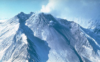
The Kamchatkan Volcanic Eruption Response Team (KVERT) reported increased activity at Bezymianny and tall ash plumes on 23 April. A large thermal anomaly was visible in satellite images for several days during 17-24 April. Incandescent avalanches continued to descend the flanks. Ash clouds from the avalanches rose 4 km (13,100 ft) a.s.l. and drifted 36 km W on 20 April, rose 2.5-3 km (8,200-9,800 ft) a.s.l. and drifted 45 km WSW on 21 April, and rose up to 4 km and drifted 35 km W on 22 April.
At about 0145 on 23 April eruptive activity produced a dense ash plume that rose to 9 km (29,500 ft) a.s.l. An ash cloud, 10 x 10 km in dimension, was visible in satellite images drifting NNW. At 0351 the Aviation Color Code was raised to Red (the highest level on a four-color scale). Hot avalanches continued to descend the flanks and gas-and-steam emissions were visible. Ash was not visible in subsequent images; at 0600 on 23 April the Aviation Color Code was lowered to Orange. A stronger explosive eruption began later that day at 2310 and produced an ash plume that rose 11 km (36,100 ft) a.s.l. Satellite images showed a 36 x 26 km ash cloud drifting NNE. At 2348 the Aviation Color Code was raised to Red. The period of increased activity ended at around 0300 on 24 April. Ashfall was reported in the villages of Atlasovo, Lazo, and Milkovo. According to Kamchatka Volcanological Station (Volkstat) pyroclastic flows descended the flanks. KVERT noted that at 0510 a satellite images showed an ash cloud at altitudes of 7-7.5 km (23,000-24,600 ft) a.s.l. that was covered 110 x 175 km and had reached about 320 km SW of the volcano. At 0600 the Aviation Color Code was lowered to Orange. Dates are reported in UTC; specific events are in local time where noted.
Geological Summary. The modern Bezymianny, much smaller than its massive neighbors Kamen and Kliuchevskoi on the Kamchatka Peninsula, was formed about 4,700 years ago over a late-Pleistocene lava-dome complex and an edifice built about 11,000-7,000 years ago. Three periods of intensified activity have occurred during the past 3,000 years. The latest period, which was preceded by a 1,000-year quiescence, began with the dramatic 1955-56 eruption. This eruption, similar to that of St. Helens in 1980, produced a large open crater that was formed by collapse of the summit and an associated lateral blast. Subsequent episodic but ongoing lava-dome growth, accompanied by intermittent explosive activity and pyroclastic flows, has largely filled the 1956 crater.
Sources: Kamchatkan Volcanic Eruption Response Team (KVERT), Kamchatka Volcanological Station