
High CO2 at Lakes Nyos and Monoun, April-May 1998
Only three lakes in the world are known to contain high concentrations of dissolved gas in their bottom waters: Lakes Nyos and Monoun in Cameroon and Lake Kivu in East Africa. The release of large quantities of gas from lakes is very rare; however, massive carbon dioxide gas (CO2) releases from Lake Monoun in 1984 (SEAN 09:08) and Lake Nyos in 1986 (SEAN 11:08) resulted in the loss of nearly 1,800 lives.
A joint team comprising U.S., Cameroonian, and Japanese scientists continues to investigate the cause of these lethal CO2 releases, the potential for future events, and hazard remediation. The following is a summary of the team's preliminary findings as contained in a report for April-May 1998 (Kling and others, 1998).
The report stated that the total gas content in the two lakes was very high and continued to build from supplies of CO2 that discharge from underground springs in the bottom of the lakes. Likelihood of a gas release can be estimated from the degree of gas saturation (the ratio of gas pressure to hydrostatic pressure) in the bottom waters. Measurements established that the subsurface gas pressure is mainly due to dissolved CO2.
Figure 3 shows gas pressure plotted against depth in the lake from measurements made in Lake Nyos starting in 1989. Pressure has increased at all depths below 170 m since then; the largest increases occurred in the bottom 20 m of the lake. Gas pressure at lake bottom exceeds 13 bars, more than 60% of the saturation value based on an ambient hydrostatic pressure at that depth (21 bars).
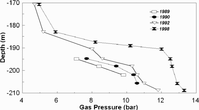 |
Figure 3. Gas pressure as a function of depth in Lake Nyos for four years (1989, 1990, 1992, and 1998). The 210 m depth represents the lake bottom. From Kling and others (1998). |
In Lake Monoun gas pressure also increased, reaching about 83% of the saturation pressure at 60-m depth. While the current gas saturation for both lakes remains below 100%, any large disturbance of the water column could trigger a violent release of the residual gas in these lakes. A frequently cited analogy to this process is the removal of the cap from a bottle of soda and the consequent drop in confining pressure enabling the gas dissolved in the soda to form bubbles. Once bubbles are formed in the lake they rise rapidly and drag the deep water toward the surface, drawing additional water upward in a chain reaction that can violently liberate enormous amounts of gas. Thus, the threat of a future lethal gas release is increasing.
A brief summary of the approximate water temperature and significant chemical parameters (alkalinity, pH, dissolved oxygen, and conductivity) in Lake Nyos as a function of depth is presented in table 1; the trends in Lake Monoun are similar. Comprehensive details are available in the complete report. Both lakes are warmer at shallow depths and near the bottom than at intermediate depths; for Nyos the coolest temperatures (~22.5°C) appear at near 40-m depth. Nyos lake water has become increasingly similar to that seen in 1985 prior to the massive CO2 release.
Table 1. Some physicochemical parameters of water in Lake Nyos. The temperature values are estimates taken from plots in the original report. Conductivity refers to specific conductivity in microSiemens per centimeter. Data from Kling and others (1998).
| Depth (m) | Temperature (°C) | Conductivity (µS/cm) | pH | Oxygen (mg/L as O2) | Bicarbonate (mg/L as HCO3-) |
| 0 | ~ 27.2 | 52 | 8.73 | 8.12 | -- |
| 30 | ~ 22.5 | 57 | 6.31 | 2.26 | 41 |
| 50 | ~ 22.5 | 526 | 5.46 | 0 | 371 |
| 100 | ~ 23.2 | 764 | 5.25 | 0 | 553 |
| 200 | ~ 25.3 | 1,500 | 4.95 | 0 | 1,102 |
A simple remedy to eliminate future lethal gas buildup involves removal of gas from the gas-rich bottom water of the lakes by pumping it through pipes to a suitable disposal area on the surface (BGVN 15:11). The scheme has been submitted by the Cameroonian government to the Japanese Embassy and Ministry of Foreign Affairs for funding. The energy released due to bubble formation (degassing) as the fluid rises is sufficient to drive the pumping operation without any external power source. This approach was validated by two demonstration projects, one in Lake Monoun in 1992 and one in Lake Nyos in 1995. In addition, future gas buildups can be prevented by continually flushing the bottom water out of the lakes through a pipe.
Lake Nyos has a weak natural dam at the outlet whose failure would cause a devastating flood that could affect up to 10,000 people in the downstream flood plain. However, pumping the gas-rich bottom water as noted above would also lower the lake water level, eliminating the flooding threat.
The people living close to these lakes need to be made aware of the risks from gas release and potential flooding. Toward this end, several Cameroonian Ministries have cooperated to produce a national plan for prevention and management of natural hazards.
In 1997 an international committee was established to help coordinate and advise the degassing efforts. This committee, named the NMDP Advisory Committee (Nyos-Monoun Degassing Project), includes members from six countries.
References. Kling, G., Evans, W., Tanyileke, G., and Kusakabe, M., 1998, Scientific investigation of Lakes Nyos and Monoun, Cameroon: Preliminary report, April-May 1998, for NMDP Advisory Committee. http://www.biology.lsa.umich.edu/~gwk/research/nm98rept.html.
Information Contacts: George Kling, University of Michigan, Ann Arbor MI 48109, USA; William Evans, U.S. Geological Survey, Menlo Park CA 94025, USA; Gregory Tanyileke, IRGM, BP 4110, MINREST, Yaounde, Cameroon; Minoru Kusakabe, Okayama University, Misasa, Tottori-ken 682-0192, Japan.
The Global Volcanism Program has no Weekly Reports available for Oku Volcanic Field.
Reports are organized chronologically and indexed below by Month/Year (Publication Volume:Number), and include a one-line summary. Click on the index link or scroll down to read the reports.
Poisonous gas from Lake Monoun explosion kills 37
Before dawn on 16 August an explosion in Lake Monoun (~7 km [corrected from 1 km] from the village of Fuombot and 218 km NE of Mt. Cameroon) produced a 5-m water wave [shock waves and burned vegetation were originally reported by the embassy], flattening vegetation around the lake. A white cloud in the vicinity of the lake at daybreak looked like typical fog, but contained poisonous gas that killed 37 people. Victims suffered vomiting, paralysis, and very rapid death; some lost the outer layer of their skin. The Cameroon government sent a team of investigators to the scene, who collected samples of rock and damaged vegetation. Residents fled the area but most had returned to their homes within a few days. As of late August, the lake water was still reddish.
No previous eruptions are known from Lake Monoun. A 1:1,000,000 geologic map shows basalts and some rhyolites and trachytes in the area but the rocks are not dated (Le Marechal, 1975a). Lake Monoun is located at the intersection of an E-W trending zone of mylonites and the Cameroon Line (Le Marechal, 1975b), a chain of Tertiary to Recent generally alkaline volcanoes extending from Annobon Island in the Atlantic Ocean northeastward through Cameroon, dividing into two branches at its northeastern end (Fitton, 1980, and figure 1). Mt. Cameroon, the only known site of Recent volcanism along the Cameroon Line, last erupted October-November 1982. Rocks as old as 31 million years have been dated along the Cameroon Line (on Principe Island; Fitton, 1980).
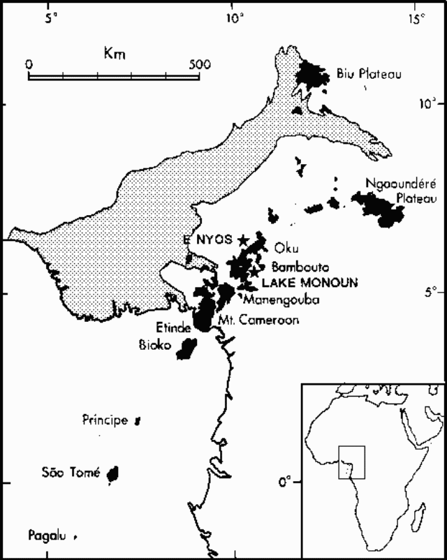 |
Figure 1. Map of the Cameroon Line and Benue Trough, after Fitton and Dunlop (1985). Volcanic rocks are shown in black. The approximate position of lakes Monoun and Nyos are indicated by stars. |
References. Fitton, J. G., 1980, The Benue Trough and Cameroon Line- a migrating rift system in West Africa: Earth and Planetary Science Letters, v. 51, p. 132-138.
Le Marechal, A., 1975a, Carte geologique de l'ouest du Cameroun et de l' Adamaoua, 1:1,000,000; ORSTOM.
Le Marechal, A., 1975b, Directions structurales de l'ouest du Cameroun et de l'Adamaoua, 1:1,000,000; ORSTOM.
Information Contacts: C. Twining, American Embassy, Douala; Yaoundé Domestic Radio Service.
Fatal 1984 gas emission may have been caused by sudden release of dissolved CO
In March 1985, Haraldur Sigurdsson, J.D. Devine, and F. Tchoua investigated the August 1984 event. The following briefly summarizes their findings; Sigurdsson and others have submitted a paper for publication and they will also present their data in December at the American Geophysical Union meeting in San Francisco.
On 15 August at about 2330, several people heard a loud noise or explosion from the Lake Monoun area and there were unconfirmed reports that an earthquake was felt that day at a town 6 km N of the lake. The gas cloud was emitted from the E part of the lake, where a crater about 350 m in diameter and at least 96 m deep is located. Victims of the cloud were in a low-lying area and had apparently died between 0300 and dawn. No autopsies were performed and the exact causes of death are unknown; all bodies had suffered skin damage [corrected from first-degree burns]. Persons on the fringes of the cloud reported that it smelled bitter and acidic. From 0630 until it dissipated by 1030, the whitish, smoke-like cloud remained 0-3 m above the ground. Vegetation was flattened within 100 m of the lake's east end, indicating that a water wave as much as 5 m above lake level was associated with the event.
Lake Monoun is near the center of a volcanic field that includes at least 34 recent craters, and there is evidence that eruptive activity has occurred there as recently as a few hundred years ago. However, the chemistry of the lake water and sediments, the uniformly low lake temperature (23-24°C), and the absence of new tephra in or around the lake suggested to the research team that the August 1984 event was not the result of an eruption or a sudden ejection of volcanic gas from the lake. Gradual emission of CO2 from volcanic vents is thought to have led to a buildup of HCO3 in the lake. An earthquake or internal seiche is thought to have upset the density stratification of the lake, triggering its overturn and catastrophic exsolution of CO2, which suffocated the victims. Explanations of the cloud's acid odor and the agent of victims' skin damage are uncertain.
[Two years later, 1,700 people perished 100 km to the NNW (figure 1) when CO2 was suddenly exsolved from Lake Nyos and flowed down several inhabited valleys. Results of initial research on this newly recognized hazard are summarized by Sigurdsson (1987), drawing substantially on discussions at the March 1987 international conference in Yaoundé, Cameroon.]
Further References. Tchoua, F.M., 1983, The phreatomagmatic explosions of Monoun: Rev. Sci. Tech., v. 3, p. 87-97.
Sigurdsson, H., Devine, J.D., Tchoua, F.M., and others, 1987, Origin of the lethal gas burst from Lake Monoun, Cameroon: JVGR, v. 31, p. 1-16.
Sigurdsson, H., 1987, Lethal gas bursts from Cameroon crater lakes: EOS, v. 68, no. 23, p. 570-573.
Information Contacts: H. Sigurdsson, Univ. of Rhode Island.
Toxic gas cloud from Lake Nyos kills more than 1,700 people
During the evening of 21 August a toxic gas cloud emerged from a lake within a young volcanic crater in NW Cameroon, killing >1,700 people and uncounted numbers of animals. Scientists investigating the disaster suggested that the lake may [be underlain by] a recent diatreme [Kling and others, 1987].
Scientists interviewed many of the survivors (>300 were hospitalized), and took gas and water samples from the lake and streams. Medical and geological investigations suggest that victims were suffocated by CO2 gas; there was no evidence that HCN or CO were present. Many survivors reported that the odor of gunpowder or rotten eggs permeated the area for ~2 days after the event and many had chemical burns on their skin (Koenigsberg and others, 1986). Positions of dead animals suggested that the gas cloud [reached as high as] 100 m above of the lake surface as it moved out of the crater, over low spots in the rim. The CO2-laden cloud blanketed low areas around the lake. Some of the cloud moved N over the outflow, followed two stream valleys for ~1 km, then turned NE along a larger river valley and through the village of Nyos, asphyxiating most of the inhabitants in the area (figure 2). Gas that flowed W from the lake followed the Cha valley for [~15] km, causing many casualties. Portions of the gas cloud had enough density and velocity to knock down corn and banana plants in a few areas as it moved outward. Gas clouds also moved to the S along the inflow streams, spreading over a wide area, and over the E rim into a low-lying pocket.
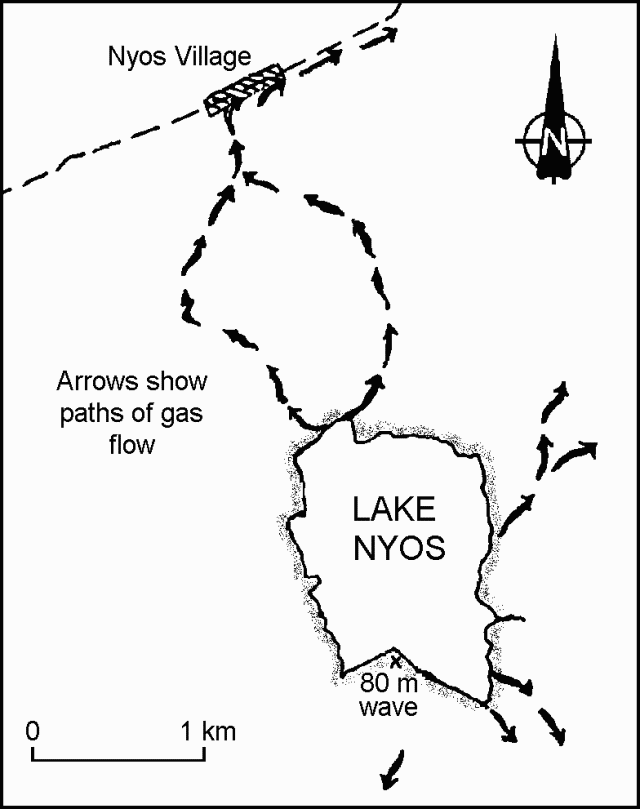 |
Figure 2. Sketch map showing the paths taken by gas flowing from Lake Nyos. [Corrected from original Bulletin.] |
Prior to the event, Lake Nyos had been clear, . . . but afterward the upper 10 m was red/brown in color, and the water had a high CO2 content. No gas bubbles had been observed before the event, nor were there reports of earthquakes. [At the beginning of] the event, however, bubbling and low rumblings were heard by a few people living close to the lake. One witness saw a cloud that appeared to be luminous suspended above the lake for a time. Another witness observed a large surge of water wash onto a small peninsula on the S side of the lake, and F. LeGuern later measured its height at 80 m above the lake. Along the E shore the surge height reached [~6] m and water had overflowed the natural spillway to the N by [~4] m. . . .
[Associated with] the emergence of the cloud, the lake level dropped [by ~1 m]. CO2 apparently continued to emanate from the lake water for several days after the event, as people collapsed at low-lying stream crossings.
A preliminary survey, using a small depth-finder, shows that the lake bottom drops off sharply from ~40 m to a flat crater floor at [208] m. Two shallow channels 15 m deep and 100 m wide extend from the base of the inflow streams and join ~500 m from the shore. The depth survey revealed no evidence of bottom sediment disruption but could not define small structures at [the bottom]. The lake temperature was nearly uniform with surface water at 22°C and bottom water at 23°C. Bicarbonate content of the [bottom] water was high (722 mg/l) and the pH was ~5.15. The surface water was well oxygenated, but the lake was anoxic below 10 m. Water samples were taken at 50, 100, and 150 m; deep water samples effervesced as they were brought to the surface, losing as much as [90%] of their volume. The water was clear at depth with a high iron content that formed a reddish precipitate when exposed to air. Sediments dredged from the lake bottom were clastic, dark brown in color, and had no sulfurous smell.
[The gas has a magmatic source but] the mechanism that triggered its release from the lake remain uncertain. The U.S. scientific team noted that: 1) There is no evidence for a direct volcanic or seismic trigger for the event; however, the nearest seismograph is 150 km SW; 2) Sudden injection of hot volcanic gas through the lake bottom or sudden release of a magmatic gas bubble trapped beneath bottom sediments appear unlikely, since the lake water temperature was low and uniform after the event, and there was no evidence that bottom sediments had been recently disrupted; 3) Slow seepage of low-temperature CO2-rich magmatic gas into the lake could have culminated in a catastrophic gas ejection when solubility limits of bottom water were exceeded; and 4) If the lake had previously been stratified (cooler, denser bottom water underlying a warmer surface layer), mixing or overturn could have brought gas-saturated water from depth to the surface. The resulting pressure drop would then have triggered a rapid gas release. Surface water temperatures are cooler during the rainy season, reducing density contrasts and therefore decreasing the stability of the lake's stratification. Turbulence generated by winds, waves, or a landslide might have triggered an overturn. . . .
During the dry season, the level of Lake Nyos drops, but during the rainy season (May-September), a [45-m] waterfall develops at the outflow. The waterfall spills over a natural dam of pyroclastic deposits, the [bottom 6] m of which are weakly consolidated. Leakage through the [lower, more permeable parts of the] dam, even during the dry season, suggests that it is unstable and poses a hazard to residents in the valley.
George Kling . . . identified 31 crater and maar lakes in NW Cameroon. Many are young and some appear to have formed within the past thousand years. Of the 17 lakes that Kling was able to sample, only Lake Nyos and Lake Monoun contained significant quantities of dissolved CO2. No record of gas emission is known before the 1984 event at Lake Monoun, but no efforts have yet been made to explore the rich oral history of the region.
Information Contacts: J. Devine, Brown Univ; J. Lockwood, HVO; H. Compton and A. Humphrey, EPA; W. Evans and M. Tuttle, USGS; G. Kling, Duke Univ.
Additional observations by Italian team
A technical mission sent . . . by the Italian Ministry of Civil Protection arrived . . . seven days after the catastrophe. On 28 August at 1445, with the air temperature at 23°C, they measured a temperature of 30°C (with an Orion digital thermometer) and a pH of 6.75 in the uppermost 2 m of lake water from the NW shore. During their 29 August-4 September depth survey, the U.S. team measured a minimum surface water temperature of 22°C and bottom water was at 23°C; pH was 5.15. Measurements of lake temperatures and pH values appeared to be affected by the amount of sunshine and rainfall (in one instance, nearly [13 cm] of rain fell in 1 hour) in the area.
The Italian team reported that data (provided by the prefecture of Wum) on the distribution of victims, and their own field observations on the distribution of dead animals suggested that the gas cloud had lethal CO2 concentrations up to 50 m above the bottom of the valley that extends from the lake spillway to Nyos and Cha villages. However, the mild effects on vegetation (withering of palm and reed leaves) were only observed up to 4-6 m on the valley floor. The gas cloud dissipated rapidly in some areas; a motorcycle rider could safely reach . . . Cha ~2 hours after the event.
Dr. Chiara Monzali, medical expert of the Italian mission, concluded that the first-degree skin burns observed on some survivors were most likely produced by a hot humid cloud (at ~50-70°C) and not by acid gases. The very mild effects on the vegetation in the valleys affected by the gas cloud seemed, to the Italian team, to confirm the medical evaluation. . . . . Investigations of industrial CO2 accidents in the U.S. have shown that breathing high levels of the gas can cause some failure of the circulatory system near the skin. This can lead to sloughing of the skin, producing lesions similar to those seen on some of the survivors. As reported in 11:8, survivors in some areas remained unconscious for many hours. An anesthesiologist noted that they would remain unconscious as long as high levels of CO2 remained in the air.
Italian volcanologists suggested that the gas blast was produced by a sudden injection of hot fluids with a high CO2 content into the lake bottom. Chemical analyses of the lake water (down to 2 m depth) indicated high CO2 partial pressure (up to 100 times atmospheric equilibrium). The geologic setting . . . would allow the presence of hot geothermal fluids in the subsoil (recent volcanic activity and deeply fractured granitic basement allowing circulation of fluids to great depth with consequent heating). They noted that if CO2 release had occurred from deep gas-saturated lake water brought to the surface, it would have necessarily induced a marked reduction in the lake water volume. Unfortunately, few data are available on lake level changes. However, helicopter pilots who flew over the lake on 21 August reported that the lake level was ~1 m below the spillway, and that the outflow of the lake had stopped temporarily after the event.
Information Contacts: F. Barberi and G. Marinelli, Univ di Pisa; W. Chelini, Geothermal Division, AGIP S.P.A., Milano, Italy; M. Martini, Univ di Firenze; E. Koenigsberg, OFDA.
Three explosions in 5 minutes; red stain in lake center the next morning
The following is from Haroun Tazieff.
"Rose-Marie Chevrier spent 4 days at Lake Nyos, 30 December-2 January. During this period, she carried out a series of measurements of the CO2 content, pH, and electrical conductivity of the air, lake water, and soil. She collected a series of gas, water, soil, and rock samples that will be analyzed in the laboratory.
"On 30 December at 1955, she felt slightly unwell as she measured the CO2 content of the air, discovering that it was ~4x the normal value that she had previously measured. The night was moonless and the weather foggy. At 1959, an explosion occurred in the lake, followed within 3 minutes by two stronger ones. The last one was accompanied by one flare of white light. The next morning, a red stain, 200 m across, was observed in the central part of the lake, which is ~800 m wide [see also 12:1]. Such a stain had been observed during the week that followed the catastrophic event of 21 August (see report by Tazieff, LeGuern, and Faivre-Pierret). On 31 December, Chevrier received evidence from several witnesses that similar stains had also been observed one week before. These red stains are most probably due to the colloidal oxidized iron on the silt accumulated on the lake bottom, 220 m below the surface.
"These facts tend to corroborate the phreatic eruption hypothesis to account for the 21 August disaster. They also show that the phreatic crisis is not yet over and that the phreatic eruption that occurred in December and probably those that could still occur will be far less violent than the 21 August event. To the contrary, the latter ones are not accompanied by a huge amount of practically pure CO2. The fact that a few minutes before the first 30 December eruption the CO2 content in the air had almost certainly been quadrupled is most likely due to the initial phase of the phreatic eruption. Experience previously acquired by the team Tazieff, LeGuern, Chevrier, and Faivre-Pierret induced us to ascribe this content increase to the sudden release of the trapped gas from its deep-seated reservoir. Such a release begins with the opening of narrow fissures in the rock reservoir cap. The affected section of these fissures allows a small amount of accumulated gas phase to escape. It escapes, because of its own pressure and the thinness of the fissure section, at very high, even supersonic, speed. The total amount of gas released during this initial phase is comparatively small but large enough to pollute the atmosphere. This initial phase ends when the total effective section of the fissure has been enlarged by mechanical abrasion of the violent gas stream over a certain threshold, above which huge amounts of gas phase may be rapidly liberated, so starting the second or main phase of the phreatic eruption. The first phase according to our own experience lasts some tens to a few hundreds of seconds. The main phase lasts until the gas pressure in the reservoir is high enough to provide the violent emission, characterizing this type of event, ending abruptly because the water acts as a stopper. Subaerial eruptions finish more progressively as at Soufrière or Dieng, or even last for a few months."
Information Contacts: F. LeGuern, CNRS, France.
Rockfalls; Lake Nyos remains clear; samples taken
H. Sigurdsson and W. Evans visited Lake Nyos 20-25 January. Their preliminary report is excerpted below.
"We made temperature profiles of the lake, conducted a bathymetric survey, collected samples of water and gas from various depths, and made excursions to Lake Njupi and nearby springs.
"By mid-September, the reddish color on the surface of Lake Nyos had disappeared, leaving the lake clear as before the August event. On 15 December, some Cameroonian soldiers reported that the surface had again turned red. This observation was confirmed by local residents. On 30 December R. Chevrier and Eyike Emannuel made camp at the outflow of the lake (11:12). At about 2000, Chevrier heard an unusual noise, followed by rumbling. Emmanuel heard waves on the lake a few minutes later. They then heard two more noises, from the direction of Lake Njupi (1 km to the NE), accompanied by flashes of whitish light. Neither geologist smelled any sulfurous odor, but Chevrier reported a smell of ozone. The following day they noted a reddish spot on the surface of Lake Nyos, and a day later, from a high vantage point, could see that Lake Njupi was also red. However, a helicopter pilot reported that this color change had occurred by 14 December and several residents stated that this lake turns red every dry season.
"During our stay, Lake Nyos was clear and quiet. On one calm day we noted that a thin film of reddish ferric hydroxide had formed on the lake surface in sheltered areas. Rockfalls occurred from the near-vertical cliffs surrounding the lake. We witnessed one of the rockfalls occurring from a canyon or fault on the SW side of the lake. Another rockfall that occurred at night was sufficiently loud to awaken us in our camp on a ridge at the NW end of the lake. Cliffs around the lake showed several scars from earlier rockfalls or landslides. These are potentially important as triggering mechanisms of the August 1986 overturn and gas burst. It is possible that the noise and rumbling heard by Chevrier and the waves noted by Emmanuel on 30 December were produced by a rockfall. This rockfall may have induced a minor upwelling of anoxic deep water, with the resulting oxidation causing a reddish stain of ferric hydroxides in surface water.
"Temperature readings were taken from the surface to the lake bottom at 1.5-m intervals with a thermocouple. Bottom water temperature was also determined with high-precision reversible mercury thermometers. All indicated a deep water temperature of 23.7-24°C. The water temperature of Lake Njupi was determined as 24.5°C.
"The bathymetry . . . was determined by five traverses over the deepest part of the lake with a recording fathometer, revealing a deep basin, with very steep or near-vertical sides and a horizontal, flat, uniform bottom at a depth of ~206 m. The survey showed no change since August 1986 (11:08). Thus, there has been no apparent disruption . . . from volcanic explosions or large-scale gas venting.
"Preliminary results of water samples showed a surface pH of 6.3 and bottom water pH of 5.4. Alkalinity at the surface was 161 mg/l, increasing to 840 mg/l at the lake bottom. Water sampled from a spring-fed creek 0.5 km N of the lake was gas-rich and reddish-colored from ferric hydroxide precipitates. Preliminary chemistry results show a high gas content, low pH, and high alkalinity, indicating that the derivation of the springs is seepage from Lake Nyos. This creek was clear when visited in September 1986. The report by Marechal (1976) of soda springs with this chemistry around Lake Nyos indicates that the current composition of Lake Nyos is not a recent feature, but that the lake has fed soda springs at least a decade before the August event. Gas samples were collected in prototype pressure cylinders for analysis in the U.S.
"Our studies of Lake Nyos 20-25 January show no evidence of recent volcanic activity in the lake. The consistent and low temperature of bottom waters shows that no significant thermal input has occurred, other than that associated with a normal geothermal heat flux. Similarly, the bathymetric surveys show that the lake floor remains flat and undisturbed. There is no evidence of recent cratering or a subaqueous volcanic cone, as would be expected in the case of an eruption or deep-seated explosion.
"Evidence from this and previous studies suggests that these events do not represent volcanic eruptions, but are due to overturn and large-scale exsolution of CO2 from deep waters. Examination of the steep, >100-m cliffs bounding the lake to the W suggests that rockfalls may also have played an important role in the August 1986 episode."
Reference. Marechal, A., 1976, Geologie et geochimie des sources thermominerales du Cameroun: ORSTOM, Paris, 176 p.
Information Contacts: H. Sigurdsson, Univ of Rhode Island; W. Evans, USGS.
Working group assessment; temperature, ion concentration, and gas pressure increase
Research continues at Lake Nyos and on the broader problem of gas-charged lakes. Quoted material is from William Evans.
"The International Working Group on Crater Lakes (IWGCL) met 11-12 September in Nancy, France to discuss the hazards associated with Lake Nyos. Scientific teams from Cameroon, France, Germany, Japan, Nigeria, Switzerland, the UK, and USA attended the meeting, held at the 15th Colloquium on African Geology. The goal of the meeting was to prepare a document containing conclusions and recommendations regarding Lake Nyos that could be presented to the government of Cameroon. Each IWGCL member present could prevent the use of any statement in the document. At the conclusion of the meeting, there was unanimous agreement on the wording to be used. The following is a complete list of the conclusions and recommendations drawn up at the meeting."
Conclusions. 1) The 1986 gas disaster in Cameroon was caused by a massive release of CO2 from Lake Nyos. 2) Lake Nyos now contains ~300 x 106 m3 of CO2 and therefore remains dangerous. 3) This danger is increasing because CO2 is currently being added to Lake Nyos at a rate of at least 5 x 10⁶ m3/year.
Recommendations. 1) Another gas disaster could occur at any time. Therefore the amount of CO2 in lake Nyos should be reduced as a matter of urgency. 2) Prior to controlled degassing, equipment should be installed for continuous monitoring of the stability of the lake. 3) Pipes should be installed to remove gas-rich water from the bottom of the lake. 4) Degassed water should be discharged outside the lake basin to avoid disturbing the natural stratification of the lake. 5) The rate of water extraction should not exceed the natural water recharge rate. Lowering the lake level would increase the risk of a gas release from beneath the lake. 6) Any system for gas extraction should be tested first at Lake Monoun. 7) The stability of the natural dam at the exit to Lake Nyos and the possibility of lowering the lake level should be further investigated. [A modified version of this document was published as Freeth and others, 1990].
"There is continued interest in the problems associated with Lake Nyos and its smaller analog, Lake Monoun. Cameroon, Nigeria, and several other countries maintain long-term research efforts. Scientists from the U.S. have made three field trips to Lake Nyos in . . . December 1989 and September and December 1990, to study the stability of the natural dam and the recharge rates of water and gas. The dam, which forms a spillway for the rainy season outflow, is 43 m wide at the top but is undercut several meters at its base. It maintains lake level at ~36 m above bedrock on the downstream side. The current rate of erosion due to water flow over and through the dam is unknown, but large-scale flooding and loss of life could occur when the structure ultimately fails. Dissolved salts and gases are transported into the lake by slightly thermal soda springs on the lake bottom at 210 m depth. Because of strong stratification of the water column, the incoming fluids are trapped in the deepest water layers. Studying the recharge process thus involves measuring temporal changes in bottom waters after the August 1986 gas burst when a partial mixing of the water column occurred. Near 200 m depth, water temperature has increased to 24.5°C, 1.0°C higher than in September 1986. Ionic strength has now risen from 0.015 to 0.024 at this depth. Total dissolved gas pressures, due mainly to CO2, have also increased. The highest pressure measured, 10.6 bar at 206 m depth, is almost 50% of the saturation pressure. When completely analyzed, these data will refine existing estimates of the various recharge rates."
Further References. Freeth, S., Kling, G., Kusakabe, M., Maley, J., Tchoua, F., and Tietze, K., 1990, Conclusions from Lake Nyos disaster: Nature, v. 348, no. 6298, p. 201.
LeGuern, F. and Sigvaldason, G., eds., 1989, The Lake Nyos event and natural CO2 degassing, I: JVGR, v. 39, nos. 2-3, p. 97-275 (15 papers); II: JVGR, v. 42, no. 4, p. 307-400 (10 papers).
Lockwood, J., Costa, J., Tuttle, M., Nni, J., and Tebor, S., 1988, The potential for catastrophic dam failure at Lake Nyos Maar, Cameroon: BV, v. 50, p. 340-349.
Nojiri, Y., Kusakabe, M., Hirabayashi, J., Sato, H., Sano, Y., Shinohara, H., Njine, T., and Tanyileke, G., 1990, Gas discharge at Lake Nyos: Nature, v. 346, no. 6282, p. 322-323.
Sano, Y., Kusakabe, M., Hirabayashi, J., Nojiri, Y., Shinohara, H., Njine, T., and Tanyileke, G., 1990, Helium and carbon fluxes in Lake Nyos, Cameroon: constraint on next gas burst: Earth & Planetary Science Letters, v. 99, p. 303-314.
Information Contacts: (Conclusions and Recommendations document)M. Kusakabe, IWGCL, Japan; (Fieldwork)W. Evans, USGS; G. Kling, The Ecosystems Center, Woods Hole, MA; J. Lockwood, R. Schuster, and M. Tuttle, USGS.
High CO2 at Lakes Nyos and Monoun, April-May 1998
Only three lakes in the world are known to contain high concentrations of dissolved gas in their bottom waters: Lakes Nyos and Monoun in Cameroon and Lake Kivu in East Africa. The release of large quantities of gas from lakes is very rare; however, massive carbon dioxide gas (CO2) releases from Lake Monoun in 1984 (SEAN 09:08) and Lake Nyos in 1986 (SEAN 11:08) resulted in the loss of nearly 1,800 lives.
A joint team comprising U.S., Cameroonian, and Japanese scientists continues to investigate the cause of these lethal CO2 releases, the potential for future events, and hazard remediation. The following is a summary of the team's preliminary findings as contained in a report for April-May 1998 (Kling and others, 1998).
The report stated that the total gas content in the two lakes was very high and continued to build from supplies of CO2 that discharge from underground springs in the bottom of the lakes. Likelihood of a gas release can be estimated from the degree of gas saturation (the ratio of gas pressure to hydrostatic pressure) in the bottom waters. Measurements established that the subsurface gas pressure is mainly due to dissolved CO2.
Figure 3 shows gas pressure plotted against depth in the lake from measurements made in Lake Nyos starting in 1989. Pressure has increased at all depths below 170 m since then; the largest increases occurred in the bottom 20 m of the lake. Gas pressure at lake bottom exceeds 13 bars, more than 60% of the saturation value based on an ambient hydrostatic pressure at that depth (21 bars).
|
Figure 3. Gas pressure as a function of depth in Lake Nyos for four years (1989, 1990, 1992, and 1998). The 210 m depth represents the lake bottom. From Kling and others (1998). |
In Lake Monoun gas pressure also increased, reaching about 83% of the saturation pressure at 60-m depth. While the current gas saturation for both lakes remains below 100%, any large disturbance of the water column could trigger a violent release of the residual gas in these lakes. A frequently cited analogy to this process is the removal of the cap from a bottle of soda and the consequent drop in confining pressure enabling the gas dissolved in the soda to form bubbles. Once bubbles are formed in the lake they rise rapidly and drag the deep water toward the surface, drawing additional water upward in a chain reaction that can violently liberate enormous amounts of gas. Thus, the threat of a future lethal gas release is increasing.
A brief summary of the approximate water temperature and significant chemical parameters (alkalinity, pH, dissolved oxygen, and conductivity) in Lake Nyos as a function of depth is presented in table 1; the trends in Lake Monoun are similar. Comprehensive details are available in the complete report. Both lakes are warmer at shallow depths and near the bottom than at intermediate depths; for Nyos the coolest temperatures (~22.5°C) appear at near 40-m depth. Nyos lake water has become increasingly similar to that seen in 1985 prior to the massive CO2 release.
Table 1. Some physicochemical parameters of water in Lake Nyos. The temperature values are estimates taken from plots in the original report. Conductivity refers to specific conductivity in microSiemens per centimeter. Data from Kling and others (1998).
| Depth (m) | Temperature (°C) | Conductivity (µS/cm) | pH | Oxygen (mg/L as O2) | Bicarbonate (mg/L as HCO3-) |
| 0 | ~ 27.2 | 52 | 8.73 | 8.12 | -- |
| 30 | ~ 22.5 | 57 | 6.31 | 2.26 | 41 |
| 50 | ~ 22.5 | 526 | 5.46 | 0 | 371 |
| 100 | ~ 23.2 | 764 | 5.25 | 0 | 553 |
| 200 | ~ 25.3 | 1,500 | 4.95 | 0 | 1,102 |
A simple remedy to eliminate future lethal gas buildup involves removal of gas from the gas-rich bottom water of the lakes by pumping it through pipes to a suitable disposal area on the surface (BGVN 15:11). The scheme has been submitted by the Cameroonian government to the Japanese Embassy and Ministry of Foreign Affairs for funding. The energy released due to bubble formation (degassing) as the fluid rises is sufficient to drive the pumping operation without any external power source. This approach was validated by two demonstration projects, one in Lake Monoun in 1992 and one in Lake Nyos in 1995. In addition, future gas buildups can be prevented by continually flushing the bottom water out of the lakes through a pipe.
Lake Nyos has a weak natural dam at the outlet whose failure would cause a devastating flood that could affect up to 10,000 people in the downstream flood plain. However, pumping the gas-rich bottom water as noted above would also lower the lake water level, eliminating the flooding threat.
The people living close to these lakes need to be made aware of the risks from gas release and potential flooding. Toward this end, several Cameroonian Ministries have cooperated to produce a national plan for prevention and management of natural hazards.
In 1997 an international committee was established to help coordinate and advise the degassing efforts. This committee, named the NMDP Advisory Committee (Nyos-Monoun Degassing Project), includes members from six countries.
References. Kling, G., Evans, W., Tanyileke, G., and Kusakabe, M., 1998, Scientific investigation of Lakes Nyos and Monoun, Cameroon: Preliminary report, April-May 1998, for NMDP Advisory Committee. http://www.biology.lsa.umich.edu/~gwk/research/nm98rept.html.
Information Contacts: George Kling, University of Michigan, Ann Arbor MI 48109, USA; William Evans, U.S. Geological Survey, Menlo Park CA 94025, USA; Gregory Tanyileke, IRGM, BP 4110, MINREST, Yaounde, Cameroon; Minoru Kusakabe, Okayama University, Misasa, Tottori-ken 682-0192, Japan.
|
|
||||||||||||||||||||||||||
There is data available for 0 confirmed eruptive period.
[ 1986 Aug 21 - 1986 Dec 30 (?) ] Uncertain Eruption
| Episode 1 | Eruption (Explosive / Effusive) | Lake Nyos | |||||||||||||||||||||||||||||||||
|---|---|---|---|---|---|---|---|---|---|---|---|---|---|---|---|---|---|---|---|---|---|---|---|---|---|---|---|---|---|---|---|---|---|---|
| 1986 Aug 21 - 1986 Dec 30 (?) | Evidence from Unknown | |||||||||||||||||||||||||||||||||
|
List of 5 Events for Episode 1 at Lake Nyos
|
||||||||||||||||||||||||||||||||||
[ 1550 ± 100 years ] Uncertain Eruption
| Episode 1 | Eruption (Explosive / Effusive) | Lake Nyos | ||||||||||||||||||||||||||||
|---|---|---|---|---|---|---|---|---|---|---|---|---|---|---|---|---|---|---|---|---|---|---|---|---|---|---|---|---|---|
| 1550 ± 100 years - Unknown | Evidence from Unknown | ||||||||||||||||||||||||||||
|
List of 4 Events for Episode 1 at Lake Nyos
|
|||||||||||||||||||||||||||||
This compilation of synonyms and subsidiary features may not be comprehensive. Features are organized into four major categories: Cones, Craters, Domes, and Thermal Features. Synonyms of features appear indented below the primary name. In some cases additional feature type, elevation, or location details are provided.
Synonyms |
||||
| Foumbot Volcanic Field | ||||
Cones |
||||
| Feature Name | Feature Type | Elevation | Latitude | Longitude |
| Chapchap | Cone | 1317 m | 5° 33' 0.00" N | 10° 37' 0.00" E |
| Makwet | Cone | 1270 m | 5° 35' 0.00" N | 10° 35' 0.00" E |
| Mbatnou | Cone | 1169 m | 5° 34' 0.00" N | 10° 34' 0.00" E |
| Mfomben | Cone | 1386 m | 5° 33' 0.00" N | 10° 36' 0.00" E |
| Oku, Mount | Stratovolcano | 3011 m | ||
Craters |
||||
| Feature Name | Feature Type | Elevation | Latitude | Longitude |
| Baleng | Maar | 1114 m | 5° 32' 0.00" N | 10° 33' 0.00" E |
| Bambuluwe, Lake | Maar | 5° 55' 0.00" N | 10° 11' 0.00" E | |
| Monoun, Lake | Maar | 5° 35' 0.00" N | 10° 35' 0.00" E | |
| Negop-Ghang | Maar | 5° 33' 0.00" N | 10° 34' 0.00" E | |
| Nfou, Lake | Maar | |||
| Nfouet, Lake | Maar | 5° 32' 0.00" N | 10° 35' 0.00" E | |
| Nyi, Lake | Maar | 6° 26' 0.00" N | 10° 11' 0.00" E | |
| Nyos, Lake | Maar | 6° 26' 0.00" N | 10° 18' 0.00" E | |
| Wum, Lake | Maar | 6° 26' 0.00" N | 10° 3' 0.00" E | |
There are no samples for Oku Volcanic Field in the Smithsonian's NMNH Department of Mineral Sciences Rock and Ore collection.
| Copernicus Browser | The Copernicus Browser replaced the Sentinel Hub Playground browser in 2023, to provide access to Earth observation archives from the Copernicus Data Space Ecosystem, the main distribution platform for data from the EU Copernicus missions. |
| MIROVA | Middle InfraRed Observation of Volcanic Activity (MIROVA) is a near real time volcanic hot-spot detection system based on the analysis of MODIS (Moderate Resolution Imaging Spectroradiometer) data. In particular, MIROVA uses the Middle InfraRed Radiation (MIR), measured over target volcanoes, in order to detect, locate and measure the heat radiation sourced from volcanic activity. |
| MODVOLC Thermal Alerts | Using infrared satellite Moderate Resolution Imaging Spectroradiometer (MODIS) data, scientists at the Hawai'i Institute of Geophysics and Planetology, University of Hawai'i, developed an automated system called MODVOLC to map thermal hot-spots in near real time. For each MODIS image, the algorithm automatically scans each 1 km pixel within it to check for high-temperature hot-spots. When one is found the date, time, location, and intensity are recorded. MODIS looks at every square km of the Earth every 48 hours, once during the day and once during the night, and the presence of two MODIS sensors in space allows at least four hot-spot observations every two days. Each day updated global maps are compiled to display the locations of all hot spots detected in the previous 24 hours. There is a drop-down list with volcano names which allow users to 'zoom-in' and examine the distribution of hot-spots at a variety of spatial scales. |
|
WOVOdat
Single Volcano View Temporal Evolution of Unrest Side by Side Volcanoes |
WOVOdat is a database of volcanic unrest; instrumentally and visually recorded changes in seismicity, ground deformation, gas emission, and other parameters from their normal baselines. It is sponsored by the World Organization of Volcano Observatories (WOVO) and presently hosted at the Earth Observatory of Singapore.
GVMID Data on Volcano Monitoring Infrastructure The Global Volcano Monitoring Infrastructure Database GVMID, is aimed at documenting and improving capabilities of volcano monitoring from the ground and space. GVMID should provide a snapshot and baseline view of the techniques and instrumentation that are in place at various volcanoes, which can be use by volcano observatories as reference to setup new monitoring system or improving networks at a specific volcano. These data will allow identification of what monitoring gaps exist, which can be then targeted by remote sensing infrastructure and future instrument deployments. |
| Volcanic Hazard Maps | The IAVCEI Commission on Volcanic Hazards and Risk has a Volcanic Hazard Maps database designed to serve as a resource for hazard mappers (or other interested parties) to explore how common issues in hazard map development have been addressed at different volcanoes, in different countries, for different hazards, and for different intended audiences. In addition to the comprehensive, searchable Volcanic Hazard Maps Database, this website contains information about diversity of volcanic hazard maps, illustrated using examples from the database. This site is for educational purposes related to volcanic hazard maps. Hazard maps found on this website should not be used for emergency purposes. For the most recent, official hazard map for a particular volcano, please seek out the proper institutional authorities on the matter. |
| IRIS seismic stations/networks | Incorporated Research Institutions for Seismology (IRIS) Data Services map showing the location of seismic stations from all available networks (permanent or temporary) within a radius of 0.18° (about 20 km at mid-latitudes) from the given location of Oku Volcanic Field. Users can customize a variety of filters and options in the left panel. Note that if there are no stations are known the map will default to show the entire world with a "No data matched request" error notice. |
| UNAVCO GPS/GNSS stations | Geodetic Data Services map from UNAVCO showing the location of GPS/GNSS stations from all available networks (permanent or temporary) within a radius of 20 km from the given location of Oku Volcanic Field. Users can customize the data search based on station or network names, location, and time window. Requires Adobe Flash Player. |
| DECADE Data | The DECADE portal, still in the developmental stage, serves as an example of the proposed interoperability between The Smithsonian Institution's Global Volcanism Program, the Mapping Gas Emissions (MaGa) Database, and the EarthChem Geochemical Portal. The Deep Earth Carbon Degassing (DECADE) initiative seeks to use new and established technologies to determine accurate global fluxes of volcanic CO2 to the atmosphere, but installing CO2 monitoring networks on 20 of the world's 150 most actively degassing volcanoes. The group uses related laboratory-based studies (direct gas sampling and analysis, melt inclusions) to provide new data for direct degassing of deep earth carbon to the atmosphere. |
| Large Eruptions of Oku Volcanic Field | Information about large Quaternary eruptions (VEI >= 4) is cataloged in the Large Magnitude Explosive Volcanic Eruptions (LaMEVE) database of the Volcano Global Risk Identification and Analysis Project (VOGRIPA). |
| EarthChem | EarthChem develops and maintains databases, software, and services that support the preservation, discovery, access and analysis of geochemical data, and facilitate their integration with the broad array of other available earth science parameters. EarthChem is operated by a joint team of disciplinary scientists, data scientists, data managers and information technology developers who are part of the NSF-funded data facility Integrated Earth Data Applications (IEDA). IEDA is a collaborative effort of EarthChem and the Marine Geoscience Data System (MGDS). |


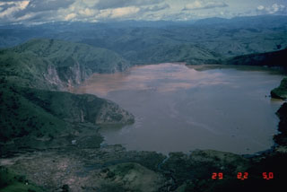 Lake Nyos is the most renowned of the numerous maars and basaltic cinder cones associated with the deeply dissected Mount Oku massif. The 1.2 x 1.9 km wide lake, seen here from the south, was the site of a gas-release event on 21 August 1986 that caused at least 1,700 fatalities. Wave damage stripped the peninsula at the left of vegetation. The emission of around 1 km3 of magmatic carbon dioxide has been attributed to either non-volcanic overturn of stratified lake waters, to phreatic explosions, or to injection of hot gas into the lake.