Cameroon Volcanoes

Cameroon has 3 Holocene volcanoes. Note that as a scientific organization we provide these listings for informational purposes only, with no international legal or policy implications. Volcanoes will be included on this list if they are within the boundaries of a country, on a shared boundary or area, in a remote territory, or within a maritime Exclusive Economic Zone. Bolded volcanoes have erupted within the past 20 years. Suggestions and data updates are always welcome ().
| Volcano Name | Last Eruption | Volcanic Region | Primary Landform |
|---|---|---|---|
| Cameroon | 2000 CE | Western Africa Volcanic Province | Composite |
| Oku Volcanic Field | Unknown - Evidence Uncertain | Western Africa Volcanic Province | Cluster |
| Tombel Graben | Unknown - Evidence Credible | Western Africa Volcanic Province | Cluster |
Chronological listing of known Holocene eruptions (confirmed or uncertain) from volcanoes in Cameroon. Bolded eruptions indicate continuing activity.
| Volcano Name | Start Date | Stop Date | Certainty | VEI | Evidence |
|---|---|---|---|---|---|
| Cameroon | 2000 May 28 | 2000 Sep 15 ± 5 days | Confirmed | 2 | Observations: Reported |
| Cameroon | 1999 Mar 28 | 1999 Apr 17 | Confirmed | 2 | Observations: Reported |
| Cameroon | 1989 May 29 | 1989 May 29 | Confirmed | 1 | Observations: Reported |
| Oku Volcanic Field | [1986 Aug 21] | [1986 Dec 30 (?)] | Uncertain | ||
| Cameroon | 1982 Oct 16 | 1982 Nov 12 | Confirmed | 2 | Observations: Reported |
| Cameroon | 1959 Jan 23 | 1959 Mar 19 | Confirmed | 2 | Observations: Reported |
| Cameroon | 1954 Jun 28 | 1954 Jul 26 | Confirmed | 2 | Observations: Reported |
| Cameroon | 1925 | Unknown | Confirmed | Observations: Reported | |
| Cameroon | 1922 Feb 3 | 1922 Aug 24 | Confirmed | 2 | Observations: Reported |
| Cameroon | 1909 Apr 28 | 1909 Jun (?) | Confirmed | 2 | Observations: Reported |
| Cameroon | 1871 | Unknown | Confirmed | 2 | Observations: Reported |
| Cameroon | 1868 | Unknown | Confirmed | 2 | Observations: Reported |
| Cameroon | 1866 Jan (?) | Unknown | Confirmed | 2 | Observations: Reported |
| Cameroon | 1865 | Unknown | Confirmed | 2 | Observations: Reported |
| Cameroon | 1852 | Unknown | Confirmed | 2 | Observations: Reported |
| Cameroon | 1838 Dec 31 ± 365 days | Unknown | Confirmed | 2 | Observations: Reported |
| Cameroon | 1825 ± 10 years | Unknown | Confirmed | 2 | Observations: Reported |
| Cameroon | 1807 ± 8 years | Unknown | Confirmed | 3 | Observations: Reported |
| Cameroon | 1650 ± 50 years | Unknown | Confirmed | 3 | Observations: Reported |
| Oku Volcanic Field | [1550 ± 100 years] | [Unknown] | Uncertain | ||
| Cameroon | 0450 BCE ± 50 years | Unknown | Confirmed | 3 | Observations: Reported |
Cameroon has 3 Pleistocene volcanoes. Note that as a scientific organization we provide these listings for informational purposes only, with no international legal or policy implications. Volcanoes will be included on this list if they are within the boundaries of a country, on a shared boundary or area, in a remote territory, or within a maritime Exclusive Economic Zone. Suggestions and data updates are always welcome ().
| Volcano Name | Volcanic Region | Primary Landform |
|---|---|---|
| Kumba Volcanic Field | Western Africa Volcanic Province | Cluster |
| Manengouba | Western Africa Volcanic Province | Composite |
| Ngaoundere Plateau | Western Africa Volcanic Province | Cluster |
There are 8 photos available for volcanoes in Cameroon.
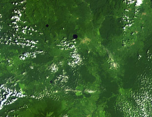 Three lake-filled maars dot the Tombel Graben between Mount Cameroon (lower left) and lava flows from Manengouba volcano (top). The Mungo River runs from N to S across the right side of this Landsat image. The largest maar, Barombi Mbo, lies just west of the brown-colored area of the town of Kumba, and Barombi Koto is at the lower left. A large number of scoria cones, including the young cone of Le Djungo (Mont Pelé) dot the 10-20 km wide graben.
NASA Landsat image, 1999 (courtesy of Hawaii Synergy Project, Univ. of Hawaii Institute of Geophysics & Planetology).
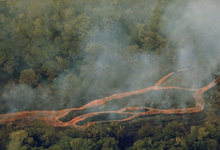 An incandescent lava flow splits into several channels as it advances through rain forest on the SW flank of Mount Cameroon. The eruption began on 16 October 1982, shortly before this photo was taken, from a fissure 6.5 km SW of the summit. Lava flows traveled 12 km down the flank to 1,200 m elevation, within about 6 km of the Atlantic coast. On 30 October the flow was about 200 m wide and 20 m thick at its terminus.
Photo courtesy of Tom Humphrey, 1982 (Gulf Oil).
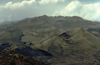 Mount Cameroon, one of Africa's largest volcanoes, rises above the coast of west Cameroon. More than 100 small cinder cones, such as those seen in this 1975 photo, occur on the flanks and surrounding lowlands. A large satellitic peak, Etinde, is located on the SW flank. During historical time, moderate explosive and effusive eruptions have occurred from both summit and flank vents. More than a dozen eruptions have been recorded since the 17th century. A lava flow from a 1922 eruption low on the SW flank reached the Atlantic Ocean.
Copyrighted photo by Katia and Maurice Krafft, 1975.
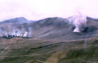
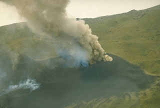 An eruption plume rises above a new scoria cone that formed on the SW flank of Mount Cameroon on 16 October 1982. The eruption occurred from a NNE-SSW-trending radial fissure at the location of an older scoria cone. A lava flow traveled 12 km down the SW flank to within about 6 km of the Atlantic coast. Two towns were evacuated, and tephra caused damage to plantations. The eruption ended on 12 November.
Photo courtesy of Tom Humphrey, 1982 (Gulf Oil).
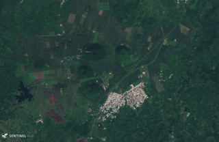 The Tombel Graben is a series of grabens that contain a monogenetic volcanic field consisting largely of scoria cones, maars, and lava flows, several of which are seen in this 13 November 2019 Sentinel-2 satellite image (N at the top). The town of Malinkam is seen here, and the larger Malinkam cone about 2 km SW is approximately 1 km wide.
Satellite image courtesy of Copernicus Sentinel Data, 2019.
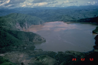 Lake Nyos is the most renowned of the numerous maars and basaltic cinder cones associated with the deeply dissected Mount Oku massif. The 1.2 x 1.9 km wide lake, seen here from the south, was the site of a gas-release event on 21 August 1986 that caused at least 1,700 fatalities. Wave damage stripped the peninsula at the left of vegetation. The emission of around 1 km3 of magmatic carbon dioxide has been attributed to either non-volcanic overturn of stratified lake waters, to phreatic explosions, or to injection of hot gas into the lake.
Photo by Jack Lockwood, 1986 (U.S. Geological Survey).
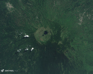 Manengouba contains the roughly 3-km wide Eboga caldera, visible in this 7 May 2019 Sentinel-2 satellite image (N at the top) around 115 km NE of Mount Cameroon. Many cones and maars have formed around the flanks, producing lava flows out to 10 km.
Satellite image courtesy of Copernicus Sentinel Data, 2019.
 Plumes rise from a crater and a lava flow near the summit of Mount Cameroon in 1982. More than 100 small cinder cones, often fissure-controlled parallel to the long axis of the massive 1,400 km3 volcano, occur on the flanks and surrounding lowlands. During historical time, explosive and effusive eruptions have occurred from both summit and flank vents. In 1922, a lava flow from a SW-flank vent reached the Atlantic Ocean.
Photo by Daniel Kergomard, 1982 (courtesy of J.G. Fitton, BRGM, France).
This is a compilation of Cameroon volcano information sources, such as official monitoring or other government agencies.
| Volcano Observatories |
|---|
| Institut de Recherches Géologiques et Minières (IRGM) |
| - IRGM Facebook |
| Volcanic Ash Advisory Center |
|---|
| Toulouse Volcanic Ash Advisory Center (VAAC) Notices and Archive |