Morphology and brief description of summit from visiting excursion
On 1 August 1999, a group from the Societe de Volcanologie Geneve ascended the ice- and rock-covered summit. On the way up the N flank they saw vertical coal deposits below 2,450 m elevation, reaching thicknesses of tens of meters. Above 4,000 m elevation huge blocks were seen that appeared to have traveled from ~1 km above. Just below the summit were large sulfur-bearing blocks that appear to be mixed with a clay- like material. Within 100 m of the N rim of the summit chunks of pure sulfur were observed. The circular summit crater was ~150 m in diameter. In the center of the crater lay a small frozen lake approximately 40 m across. From the N rim of the summit, an active fumarole could be seen to the south.
Information Contacts: D. Zurcher and R. Haubrichs, Societe de Volcanologie Geneve (SVG), C.P. 6423, CH-1211, Geneve 6, Switzerland (Bulletin de la SVG, October 1999, p. 6 (in French)).
The Global Volcanism Program has no Weekly Reports available for Damavand.
Reports are organized chronologically and indexed below by Month/Year (Publication Volume:Number), and include a one-line summary. Click on the index link or scroll down to read the reports.
Fumarolic vent on the crater rim; sulfur deposits
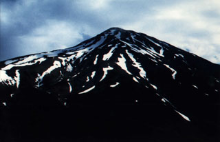
A visit to the summit area . . . on 12 July 1993 revealed a small, powerful fumarolic vent on the S rim of the crater that was emitting SO2-rich gases at a temperature of ~50°C. Sulfur deposits also covered the surrounding slopes. The summit crater was ~150 m wide and 20 m deep, with a 40-m-diameter frozen lake in the bottom, surrounded by patches of snow. . . . there is no permanent glacier because of the dry climate. However, the upper slopes do contain scattered areas of hardened perennial snow (névés).
Information Contacts: J. Sesiano, Univ de Genève.
Morphology and brief description of summit from visiting excursion
On 1 August 1999, a group from the Societe de Volcanologie Geneve ascended the ice- and rock-covered summit. On the way up the N flank they saw vertical coal deposits below 2,450 m elevation, reaching thicknesses of tens of meters. Above 4,000 m elevation huge blocks were seen that appeared to have traveled from ~1 km above. Just below the summit were large sulfur-bearing blocks that appear to be mixed with a clay- like material. Within 100 m of the N rim of the summit chunks of pure sulfur were observed. The circular summit crater was ~150 m in diameter. In the center of the crater lay a small frozen lake approximately 40 m across. From the N rim of the summit, an active fumarole could be seen to the south.
Information Contacts: D. Zurcher and R. Haubrichs, Societe de Volcanologie Geneve (SVG), C.P. 6423, CH-1211, Geneve 6, Switzerland (Bulletin de la SVG, October 1999, p. 6 (in French)).
|
|
||||||||||||||||||||||||||||
There is data available for 1 confirmed eruptive period.
5350 BCE ± 200 years Confirmed Eruption (Explosive / Effusive) VEI: 0
| Episode 1 | Eruption (Explosive / Effusive) | |||||||||||||||||||
|---|---|---|---|---|---|---|---|---|---|---|---|---|---|---|---|---|---|---|---|
| 5350 BCE ± 200 years - Unknown | Evidence from Isotopic: Uranium-series | ||||||||||||||||||
|
List of 2 Events for Episode 1
|
|||||||||||||||||||
This compilation of synonyms and subsidiary features may not be comprehensive. Features are organized into four major categories: Cones, Craters, Domes, and Thermal Features. Synonyms of features appear indented below the primary name. In some cases additional feature type, elevation, or location details are provided.
Synonyms |
||||
| Demavend | Demawend | ||||
Thermal |
||||
| Feature Name | Feature Type | Elevation | Latitude | Longitude |
| Ab E Garm | Thermal | |||
| Ask | Thermal | |||
| Baidjan | Thermal | |||
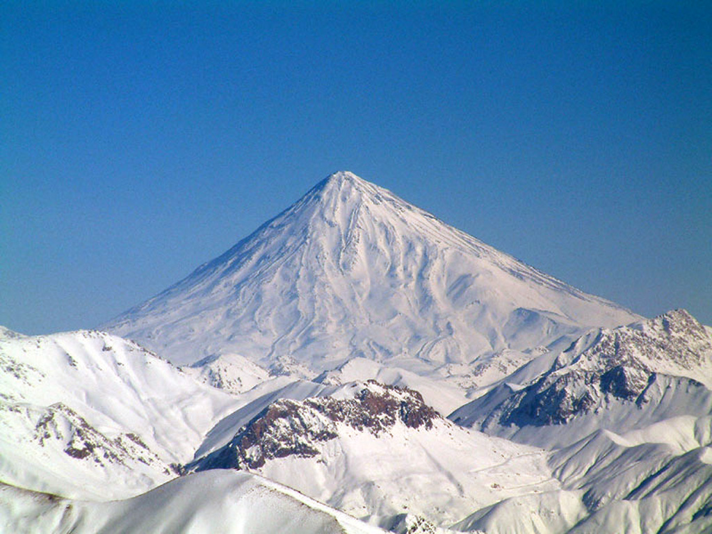
 Damavand volcano in the Elbruz mountains, about 80 km NE of Iran's capital city Tehran, is seen here from the S flank, at an elevation of 3,500 m. The summit of the stratovolcano contains a well-preserved, 150-m-wide crater with a small frozen lake. Despite its elevation above 5,000 m, the region is too arid to support permanent glaciers. Recent lava flows from the summit and flank vents cover the W side of the volcano.
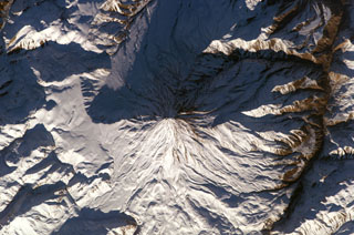 Winter snows highlight morphological features of Damavand volcano in this NASA International Space Station image (N to the upper left). Lava flows with prominent levees can be seen at the bottom of the image and a small well-preserved crater can be seen at the summit. The volcano is located about 80 km NE of the capital city of Tehran.
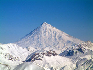 Activity at snow-capped Damavand volcano, 70 km NE of Iran's capital city of Tehran, has been dominated by lava effusion and recent lava flows erupted from the summit vent to the W. The youngest dated lava flows were erupted about 7,000 years ago. No historical eruptions are known, but hot springs are located on the flanks and fumaroles are found at the summit crater.
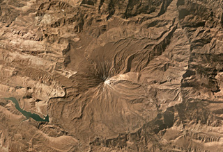 Damavand is largely composed of pyroclastic flow deposits, tephra, and radial lava flows that have erupted mostly from summit vents to form the steep flanks. The summit is near the center of this October 2019 Planet Labs satellite image monthly mosaic (N is at the top; this image is approximately 40 km across). The current cone has formed over the remains of an older cone.
There are no samples for Damavand in the Smithsonian's NMNH Department of Mineral Sciences Rock and Ore collection.
| Copernicus Browser | The Copernicus Browser replaced the Sentinel Hub Playground browser in 2023, to provide access to Earth observation archives from the Copernicus Data Space Ecosystem, the main distribution platform for data from the EU Copernicus missions. |
| MIROVA | Middle InfraRed Observation of Volcanic Activity (MIROVA) is a near real time volcanic hot-spot detection system based on the analysis of MODIS (Moderate Resolution Imaging Spectroradiometer) data. In particular, MIROVA uses the Middle InfraRed Radiation (MIR), measured over target volcanoes, in order to detect, locate and measure the heat radiation sourced from volcanic activity. |
| MODVOLC Thermal Alerts | Using infrared satellite Moderate Resolution Imaging Spectroradiometer (MODIS) data, scientists at the Hawai'i Institute of Geophysics and Planetology, University of Hawai'i, developed an automated system called MODVOLC to map thermal hot-spots in near real time. For each MODIS image, the algorithm automatically scans each 1 km pixel within it to check for high-temperature hot-spots. When one is found the date, time, location, and intensity are recorded. MODIS looks at every square km of the Earth every 48 hours, once during the day and once during the night, and the presence of two MODIS sensors in space allows at least four hot-spot observations every two days. Each day updated global maps are compiled to display the locations of all hot spots detected in the previous 24 hours. There is a drop-down list with volcano names which allow users to 'zoom-in' and examine the distribution of hot-spots at a variety of spatial scales. |
|
WOVOdat
Single Volcano View Temporal Evolution of Unrest Side by Side Volcanoes |
WOVOdat is a database of volcanic unrest; instrumentally and visually recorded changes in seismicity, ground deformation, gas emission, and other parameters from their normal baselines. It is sponsored by the World Organization of Volcano Observatories (WOVO) and presently hosted at the Earth Observatory of Singapore.
GVMID Data on Volcano Monitoring Infrastructure The Global Volcano Monitoring Infrastructure Database GVMID, is aimed at documenting and improving capabilities of volcano monitoring from the ground and space. GVMID should provide a snapshot and baseline view of the techniques and instrumentation that are in place at various volcanoes, which can be use by volcano observatories as reference to setup new monitoring system or improving networks at a specific volcano. These data will allow identification of what monitoring gaps exist, which can be then targeted by remote sensing infrastructure and future instrument deployments. |
| Volcanic Hazard Maps | The IAVCEI Commission on Volcanic Hazards and Risk has a Volcanic Hazard Maps database designed to serve as a resource for hazard mappers (or other interested parties) to explore how common issues in hazard map development have been addressed at different volcanoes, in different countries, for different hazards, and for different intended audiences. In addition to the comprehensive, searchable Volcanic Hazard Maps Database, this website contains information about diversity of volcanic hazard maps, illustrated using examples from the database. This site is for educational purposes related to volcanic hazard maps. Hazard maps found on this website should not be used for emergency purposes. For the most recent, official hazard map for a particular volcano, please seek out the proper institutional authorities on the matter. |
| IRIS seismic stations/networks | Incorporated Research Institutions for Seismology (IRIS) Data Services map showing the location of seismic stations from all available networks (permanent or temporary) within a radius of 0.18° (about 20 km at mid-latitudes) from the given location of Damavand. Users can customize a variety of filters and options in the left panel. Note that if there are no stations are known the map will default to show the entire world with a "No data matched request" error notice. |
| UNAVCO GPS/GNSS stations | Geodetic Data Services map from UNAVCO showing the location of GPS/GNSS stations from all available networks (permanent or temporary) within a radius of 20 km from the given location of Damavand. Users can customize the data search based on station or network names, location, and time window. Requires Adobe Flash Player. |
| DECADE Data | The DECADE portal, still in the developmental stage, serves as an example of the proposed interoperability between The Smithsonian Institution's Global Volcanism Program, the Mapping Gas Emissions (MaGa) Database, and the EarthChem Geochemical Portal. The Deep Earth Carbon Degassing (DECADE) initiative seeks to use new and established technologies to determine accurate global fluxes of volcanic CO2 to the atmosphere, but installing CO2 monitoring networks on 20 of the world's 150 most actively degassing volcanoes. The group uses related laboratory-based studies (direct gas sampling and analysis, melt inclusions) to provide new data for direct degassing of deep earth carbon to the atmosphere. |
| Large Eruptions of Damavand | Information about large Quaternary eruptions (VEI >= 4) is cataloged in the Large Magnitude Explosive Volcanic Eruptions (LaMEVE) database of the Volcano Global Risk Identification and Analysis Project (VOGRIPA). |
| EarthChem | EarthChem develops and maintains databases, software, and services that support the preservation, discovery, access and analysis of geochemical data, and facilitate their integration with the broad array of other available earth science parameters. EarthChem is operated by a joint team of disciplinary scientists, data scientists, data managers and information technology developers who are part of the NSF-funded data facility Integrated Earth Data Applications (IEDA). IEDA is a collaborative effort of EarthChem and the Marine Geoscience Data System (MGDS). |

