Iran Volcanoes
A map display is currently under development.
Iran has 1 Holocene volcanoes. Note that as a scientific organization we provide these listings for informational purposes only, with no international legal or policy implications. Volcanoes will be included on this list if they are within the boundaries of a country, on a shared boundary or area, in a remote territory, or within a maritime Exclusive Economic Zone. Bolded volcanoes have erupted within the past 20 years. Suggestions and data updates are always welcome ().
| Volcano Name | Last Eruption | Volcanic Region | Primary Landform |
|---|---|---|---|
| Damavand | 5350 BCE | Caucasus Volcanic Province | Composite |
Chronological listing of known Holocene eruptions (confirmed or uncertain) from volcanoes in Iran. Bolded eruptions indicate continuing activity.
Iran has 13 Pleistocene volcanoes. Note that as a scientific organization we provide these listings for informational purposes only, with no international legal or policy implications. Volcanoes will be included on this list if they are within the boundaries of a country, on a shared boundary or area, in a remote territory, or within a maritime Exclusive Economic Zone. Suggestions and data updates are always welcome ().
| Volcano Name | Volcanic Region | Primary Landform |
|---|---|---|
| Bazman | Central Asia Volcanic Province | Composite |
| Bijar Volcanic Field | Caucasus Volcanic Province | Cluster |
| Dehaj-Meduk | Central Asia Volcanic Province | Cluster |
| East Neh | Central Asia Volcanic Province | Minor |
| Gandom Beryan | Central Asia Volcanic Province | Minor |
| Kuh-e Ayyub Ansar | Caucasus Volcanic Province | Minor |
| Nader | Central Asia Volcanic Province | Cluster |
| Qal'eh Hasan Ali | Central Asia Volcanic Province | Cluster |
| Sabalan | Caucasus Volcanic Province | Composite |
| Sahand | Caucasus Volcanic Province | Composite |
| Saray | Caucasus Volcanic Province | Minor |
| Shahsavaran | Central Asia Volcanic Province | Cluster |
| Taftan | Central Asia Volcanic Province | Composite |
There are 14 photos available for volcanoes in Iran.
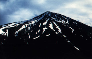 Damavand volcano in the Elbruz mountains, about 80 km NE of Iran's capital city Tehran, is seen here from the S flank, at an elevation of 3,500 m. The summit of the stratovolcano contains a well-preserved, 150-m-wide crater with a small frozen lake. Despite its elevation above 5,000 m, the region is too arid to support permanent glaciers. Recent lava flows from the summit and flank vents cover the W side of the volcano.
Photo by J. Sesiano, 1998 (University of Geneva).
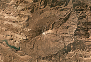 Damavand is largely composed of pyroclastic flow deposits, tephra, and radial lava flows that have erupted mostly from summit vents to form the steep flanks. The summit is near the center of this October 2019 Planet Labs satellite image monthly mosaic (N is at the top; this image is approximately 40 km across). The current cone has formed over the remains of an older cone.
Satellite image courtesy of Planet Labs Inc., 2019 (https://www.planet.com/).
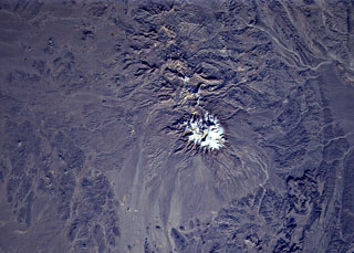
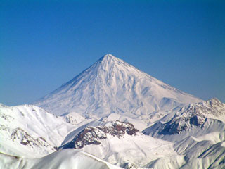 Activity at snow-capped Damavand volcano, 70 km NE of Iran's capital city of Tehran, has been dominated by lava effusion and recent lava flows erupted from the summit vent to the W. The youngest dated lava flows were erupted about 7,000 years ago. No historical eruptions are known, but hot springs are located on the flanks and fumaroles are found at the summit crater.
Photo by Arad Mojtahedi, 2006 (http://en.wikipedia.org/wiki/Image:Damavand_in_winter.jpg).
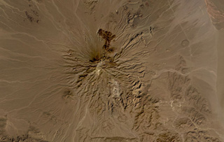 Bazman volcano is part of the Makran arc in SE Iran, shown here in this October 2019 Planet Labs satellite image monthly mosaic (N is at the top; this image is approximately 44 km across). Scoria cones and lava flows have formed across the eroded flanks, with several darker lava flows containing levees and lobate flow fronts visible on the northern flank. The Bazman granitoid complex forms part of the southern flank and formed between 83 and 72 million years ago.
Satellite image courtesy of Planet Labs Inc., 2019 (https://www.planet.com/).
 Quaternary basaltic lava flows are visible in this NASA Landsat image (N to the top) of SE Iran. The lava flows are part of unnamed volcanic field between Taftan and Bazman volcanoes. Preserved cones and craters were erupted among a group of Cretaceous limestone peaks.
NASA Landsat 7 image (worldwind.arc.nasa.gov)
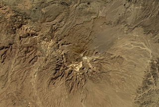 Taftan volcano in SE Iran has extensively eroded flanks composed of lava flows, pyroclastic flows, and ignimbrite deposits, shown in this October 2019 Planet Labs satellite image monthly mosaic (N is at the top; this image is approximately 42 km across). It has two main edifices, Narkuh and Matherkuh, and geothermal activity continues in the summit region.
Satellite image courtesy of Planet Labs Inc., 2019 (https://www.planet.com/).
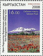 This postage stamp from Kyrgyzstan show Sabalan volcano (Kuhha-ye-Sabalan) in NW Iran. The volcano lies about 90 km W of the Caspian Sea. The glaciated volcano forms the highest point in NW Iran and is the country's 2nd highest volcano, exceeded only by Damavand. Eruptive activity at Sabalan continued into the Holocene.
Courtesy of Jim Whitford-Stark.
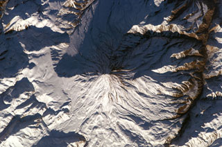 Winter snows highlight morphological features of Damavand volcano in this NASA International Space Station image (N to the upper left). Lava flows with prominent levees can be seen at the bottom of the image and a small well-preserved crater can be seen at the summit. The volcano is located about 80 km NE of the capital city of Tehran.
NASA International Space Station image ISS010-E-13393, 2005 (http://eol.jsc.nasa.gov/).
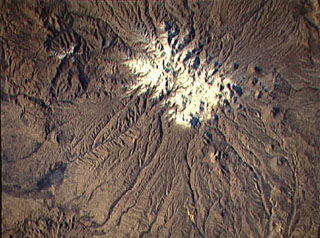
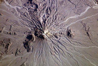 The Bazman (Kuh-e Bazman) volcano is located in remote SE Iran. A well-preserved, 500-m-wide crater caps the summit. Lava domes have been the source of viscous lava flows, including the prominent flow with visible flow levees at the lower left. No historical eruptions are known, but minor fumarolic activity has been reported.
NASA International Space Station image ISS006-E-5209, 2002 (http://eol.jsc.nasa.gov/).
 The snow-capped, eroded Taftan volcano in eastern Iran has two prominent summits. It was constructed along a volcanic zone in Beluchistan, SE Iran, that extends into northern Pakistan. The higher SE summit cone is well preserved and has been the source of very visible lava flows. Highly active, sulfur-coated fumaroles occur at the summit of the SE cone.
NASA Space Shuttle image STS80-752-40, 1996 (http://eol.jsc.nasa.gov/).
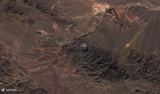 Several maars of the Qal'eh Hasan Ali volcanic field in SE Iran are visible in this 3 December 2019 Sentinel-2 satellite image (N at the top), with the largest near the center being the 1.2-km-wide, 300-m-deep Great Crater. The field contains 14 identified maar craters.
Satellite image courtesy of Copernicus Sentinel Data, 2019.
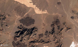 Several lava flows of the Kuh-e Nader volcanic field are visible here, located in the Nader Mountains between Taftan and Bazman volcanoes in SE Iran. Several lobate lava flow boundaries are apparent. This 3 December 2019 Sentinel-2 satellite image is approximately 18 km across (N at the top).
Satellite image courtesy of Copernicus Sentinel Data, 2019.
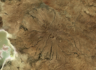 Sahand in NW Iran has heavily eroded flanks, seen in this October 2019 Planet Labs satellite image monthly mosaic (N is at the top; this image is approximately 150 km across). A caldera formed at the summit which has been largely infilled by more recent activity. Eruptive deposits from Sahand were emplaced over an area of around 3,000 km2 and lava domes and smaller cones have formed across the flanks.
Satellite image courtesy of Planet Labs Inc., 2019 (https://www.planet.com/).
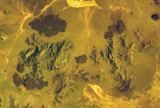
 Sahand volcano (Kuh-e-Sahand) is located in NW Iran, about 60 km E of Lake Urmia and 40 km SSE of the city of Tabriz. The city of Maragheh (darker area at bottom left) lies below the S flanks of the volcano. Numerous lava domes (upper right) occupy the lower flanks of the volcano.
NASA Space Shuttle image STS74-708-25, 1995 (http://eol.jsc.nasa.gov/).
This is a compilation of Iran volcano information sources, such as official monitoring or other government agencies.
| Volcanic Ash Advisory Center | |
|---|---|
| Toulouse Volcanic Ash Advisory Center (VAAC) Notices and Archive | |