The Global Volcanism Program has no activity reports available for Kaikohe-Bay of Islands.
The Global Volcanism Program has no Weekly Reports available for Kaikohe-Bay of Islands.
The Global Volcanism Program has no Bulletin Reports available for Kaikohe-Bay of Islands.
|
|
||||||||||||||||||||||||||||
There is data available for 0 confirmed eruptive period.
[ 0450 ± 250 years ] Discredited Eruption
Citations to a Te Puke eruption in this time period generally have their origins with Kear (1961), citing a personal communication from H.W. Wellman who identified volcanic "bombs" up to 2 inches long in coastal deposits at Onewhero. Based on dating of overlying and underlying deposits, Wellman put a date window of 700 CE (Loisel Pumice) to 200 CE (Leigh Pumice) on the deposit (see also Wellman, 1962). These basalts were presumed to have been from an eruption of Te Puke. Kear and Thompson (1964) restated this as an eruption at about 1,500 BP. | Cole and Nairn (1975, CAVW) listed multiple eruptions between 550 and 1,950 BP (combined in one entry) based on work by Kohn (1973) and Wellman (1962) dating pumice layers. | Smith (in Johnson et al., 1989) stated that the "most recent eruption was only about 1800-1300 years ago on the basis of radiocarbon dating of carbonised wood from beneath young basalt flows at Te Puke in the Bay of Islands (Kear & Hay, 1961)". The Kear and Hays (1961) geological map (not viewed by GVP staff) may reference the dating of pumice flows, but the nature and provenance of the overlying basaltic material is not clear considering the information in Kear (1961). Latter (1994 pers. comm.) noted that there is considerable doubt about the 1,500 BP date. | Stipp and Thompson (1971) obtained a K/Ar date of 17 ± 6 ka, but noted concerns that precluded "any real confidence in the indicated age". | A basalt lava flow sample from Te Puke was K/Ar dated by Smith et al. (1993) to 140 ± 6 ka, with a lava flow from Tauanui giving the youngest result from the volcanic field at 60 ± 50 ka. The same samples analyzed by Shane (reported in Coote et al., 2018) resulted in K/Ar dates of 83 ± 17 ka for Te Puke and 53 ± 21 ka for Tauanui.
This compilation of synonyms and subsidiary features may not be comprehensive. Features are organized into four major categories: Cones, Craters, Domes, and Thermal Features. Synonyms of features appear indented below the primary name. In some cases additional feature type, elevation, or location details are provided.
Synonyms |
||||
| Bay of Islands | ||||
Cones |
||||
| Feature Name | Feature Type | Elevation | Latitude | Longitude |
| Kaikohe | Cone | 282 m | 35° 25' 0.00" S | 173° 47' 0.00" E |
| Kawiti | Cone | 123 m | 35° 25' 0.00" S | 173° 58' 0.00" E |
| Keri | Cone | 35° 15' 0.00" S | 173° 57' 0.00" E | |
| Manginangina | Cone | 35° 12' 0.00" S | 173° 48' 0.00" E | |
| Maungakawakawa | Cone | 35° 21' 0.00" S | 173° 51' 0.00" E | |
| Maungaturoto | Cone | 283 m | 35° 23' 0.00" S | 173° 53' 0.00" E |
| Ngahuha | Cone | 183 m | 35° 23' 0.00" S | 173° 58' 0.00" E |
| Okaihau | Cone | 35° 17' 0.00" S | 173° 50' 0.00" E | |
| Omapere | Cone | 35° 23' 0.00" S | 173° 48' 0.00" E | |
| Otoroa | Cone | 35° 5' 0.00" S | 173° 52' 0.00" E | |
| Pahangahanga | Cone | 35° 19' 0.00" S | 173° 54' 0.00" E | |
| Poerua | Cone | 273 m | 35° 23' 0.00" S | 173° 56' 0.00" E |
| Puketutu | Cone | 101 m | 35° 18' 0.00" S | 173° 59' 0.00" E |
| Purerua | Cone | 35° 8' 0.00" S | 174° 0' 0.00" E | |
| Tahoranui | Cone | 35° 9' 0.00" S | 173° 53' 0.00" E | |
| Takou | Cone | 35° 8' 0.00" S | 173° 52' 0.00" E | |
| Tauanui | Cone | 344 m | 35° 29' 42.00" S | 173° 51' 31.56" E |
| Te Ahuahu | Cone | 378 m | 35° 21' 0.00" S | 173° 50' 0.00" E |
| Te Pene | Cone | 35° 4' 0.00" S | 173° 54' 0.00" E | |
| Te Puke | Cone | 135 m | 35° 15' 7.00" S | 174° 1' 50.00" E |
| Te Whau | Cone | 35° 9' 0.00" S | 173° 53' 0.00" E | |
| Waimate | Cone | 35° 18' 0.00" S | 173° 52' 0.00" E | |
| Waimimiti | Cone | 388 m | 35° 23' 0.00" S | 173° 50' 0.00" E |
Domes |
||||
| Feature Name | Feature Type | Elevation | Latitude | Longitude |
| Putahi | Dome | 385 m | 35° 23' 0.00" S | 173° 49' 0.00" E |
Thermal |
||||
| Feature Name | Feature Type | Elevation | Latitude | Longitude |
| Ngawha Hot Springs | Hot Spring | 35° 24' 0.00" S | 173° 52' 0.00" E | |
There are no samples for Kaikohe-Bay of Islands in the Smithsonian's NMNH Department of Mineral Sciences Rock and Ore collection.
| Copernicus Browser | The Copernicus Browser replaced the Sentinel Hub Playground browser in 2023, to provide access to Earth observation archives from the Copernicus Data Space Ecosystem, the main distribution platform for data from the EU Copernicus missions. |
|
WOVOdat
Single Volcano View Temporal Evolution of Unrest Side by Side Volcanoes |
WOVOdat is a database of volcanic unrest; instrumentally and visually recorded changes in seismicity, ground deformation, gas emission, and other parameters from their normal baselines. It is sponsored by the World Organization of Volcano Observatories (WOVO) and presently hosted at the Earth Observatory of Singapore.
GVMID Data on Volcano Monitoring Infrastructure The Global Volcano Monitoring Infrastructure Database GVMID, is aimed at documenting and improving capabilities of volcano monitoring from the ground and space. GVMID should provide a snapshot and baseline view of the techniques and instrumentation that are in place at various volcanoes, which can be use by volcano observatories as reference to setup new monitoring system or improving networks at a specific volcano. These data will allow identification of what monitoring gaps exist, which can be then targeted by remote sensing infrastructure and future instrument deployments. |
| IRIS seismic stations/networks | Incorporated Research Institutions for Seismology (IRIS) Data Services map showing the location of seismic stations from all available networks (permanent or temporary) within a radius of 0.18° (about 20 km at mid-latitudes) from the given location of Kaikohe-Bay of Islands. Users can customize a variety of filters and options in the left panel. Note that if there are no stations are known the map will default to show the entire world with a "No data matched request" error notice. |
| UNAVCO GPS/GNSS stations | Geodetic Data Services map from UNAVCO showing the location of GPS/GNSS stations from all available networks (permanent or temporary) within a radius of 20 km from the given location of Kaikohe-Bay of Islands. Users can customize the data search based on station or network names, location, and time window. Requires Adobe Flash Player. |
| Large Eruptions of Kaikohe-Bay of Islands | Information about large Quaternary eruptions (VEI >= 4) is cataloged in the Large Magnitude Explosive Volcanic Eruptions (LaMEVE) database of the Volcano Global Risk Identification and Analysis Project (VOGRIPA). |
| EarthChem | EarthChem develops and maintains databases, software, and services that support the preservation, discovery, access and analysis of geochemical data, and facilitate their integration with the broad array of other available earth science parameters. EarthChem is operated by a joint team of disciplinary scientists, data scientists, data managers and information technology developers who are part of the NSF-funded data facility Integrated Earth Data Applications (IEDA). IEDA is a collaborative effort of EarthChem and the Marine Geoscience Data System (MGDS). |


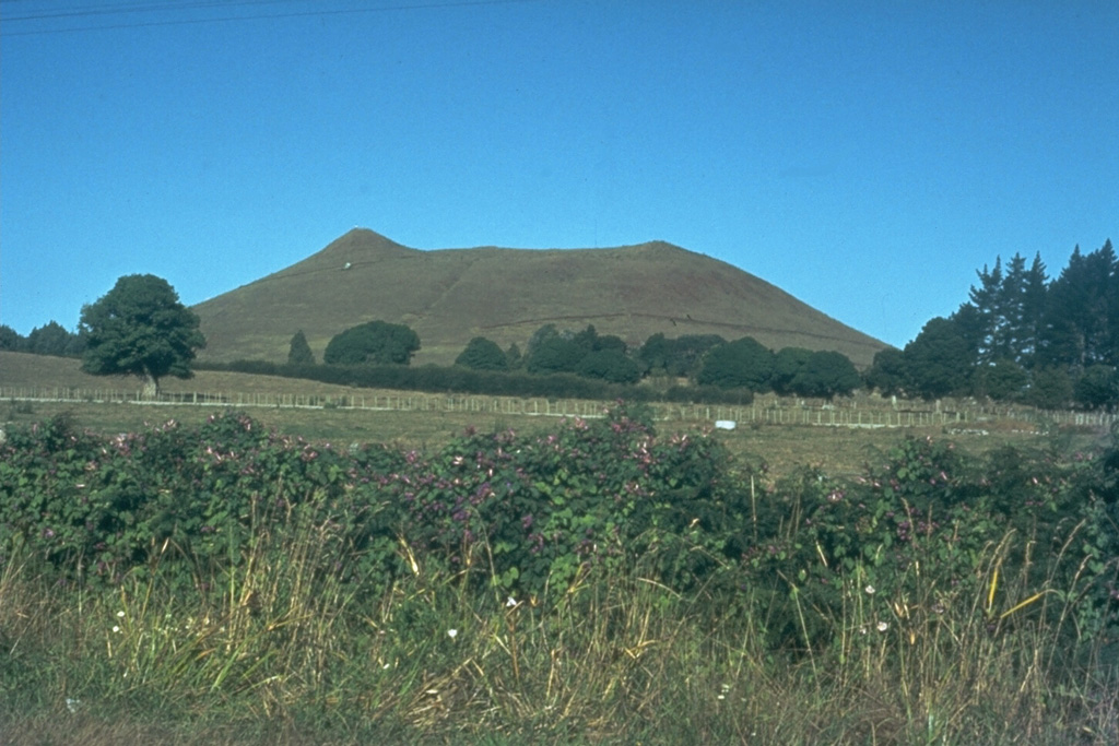
 This basaltic scoria cone is one of 30 Pleistocene to early-Holocene eruptive centers in the Kaikohe-Bay of Islands volcanic field in NW-most North Island, New Zealand. The most recent eruptions produced scoria cones and lava flows near Te Puke about 1,300-1,800 years ago. The volcanic field also contains small shield volcanoes, along with small rhyolitic lava flows and domes.