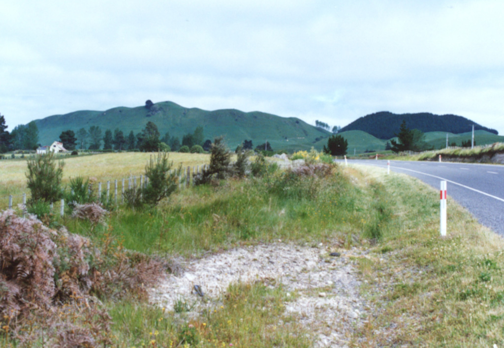
On 30 March the IGNS reported that a moderate-sized hydrothermal explosion occurred in the Alum Lakes area, Wairakei, knocking over trees and destroying vegetation near the crater. Water levels at several of the Alum Lakes had dropped several weeks before the explosion.
Source: GeoNet
2001: March
On 30 March the IGNS reported that a moderate-sized hydrothermal explosion occurred in the Alum Lakes area, Wairakei, knocking over trees and destroying vegetation near the crater. Water levels at several of the Alum Lakes had dropped several weeks before the explosion.
Source: GeoNet
The Global Volcanism Program has no Bulletin Reports available for Maroa.
|
|
||||||||||||||||||||||||||||
The Global Volcanism Program is not aware of any Holocene eruptions from Maroa. If this volcano has had large eruptions (VEI >= 4) prior to 12,000 years ago, information might be found on the Maroa page in the LaMEVE (Large Magnitude Explosive Volcanic Eruptions) database, a part of the Volcano Global Risk Identification and Analysis Project (VOGRIPA).
This compilation of synonyms and subsidiary features may not be comprehensive. Features are organized into four major categories: Cones, Craters, Domes, and Thermal Features. Synonyms of features appear indented below the primary name. In some cases additional feature type, elevation, or location details are provided.
Cones |
||||
| Feature Name | Feature Type | Elevation | Latitude | Longitude |
| Rolles Peak
Apuahoe |
Stratovolcano | 570 m | 38° 40' 0.00" S | 176° 15' 0.00" E |
Craters |
||||
| Feature Name | Feature Type | Elevation | Latitude | Longitude |
| Whakamaru | Pleistocene caldera | 38° 30' 0.00" S | 176° 5' 0.00" E | |
Domes |
||||
| Feature Name | Feature Type | Elevation | Latitude | Longitude |
| Ben Lomond | Dome | 740 m | 38° 35' 0.00" S | 175° 58' 0.00" E |
| Caws Road | Dome | 598 m | 38° 24' 0.00" S | 175° 50' 0.00" E |
| Kaimanawa | Dome | 534 m | 38° 35' 0.00" S | 176° 14' 0.00" E |
| Mangatoetoe | Dome | 641 m | 38° 30' 0.00" S | 176° 7' 0.00" E |
| Mangatutu | Dome | 525 m | 38° 25' 0.00" S | 176° 3' 0.00" E |
| Maraemanuka | Dome | 610 m | 38° 28' 0.00" S | 175° 51' 0.00" E |
| Maroa North | Dome | 770 m | 38° 28' 0.00" S | 176° 2' 0.00" E |
| Maroa South | Dome | 686 m | 38° 30' 0.00" S | 176° 2' 0.00" E |
| Maroa West | Dome | 792 m | 38° 30' 0.00" S | 176° 0' 0.00" E |
| Maroanui | Dome | 897 m | 38° 31' 0.00" S | 176° 1' 0.00" E |
| Maungaiti | Dome | 774 m | 38° 20' 0.00" S | 175° 56' 0.00" E |
| Mokai | Dome | 740 m | 38° 34' 0.00" S | 175° 55' 0.00" E |
| Ngangiho | Dome | 656 m | 38° 35' 0.00" S | 176° 3' 0.00" E |
| Ngautuku | Dome | 626 m | 38° 23' 0.00" S | 176° 1' 0.00" E |
| Oheinui | Dome | 805 m | 38° 29' 0.00" S | 176° 5' 0.00" E |
| Oruahinawe | Dome | 526 m | 38° 36' 0.00" S | 176° 7' 0.00" E |
| Oruanui | Dome | 720 m | 38° 35' 0.00" S | 176° 1' 0.00" E |
| Pohaturoa | Dome | 520 m | 38° 24' 0.00" S | 176° 1' 0.00" E |
| Pokuru | Dome | 673 m | 38° 29' 0.00" S | 175° 51' 0.00" E |
| Pukeahua | Dome | 715 m | 38° 26' 0.00" S | 176° 0' 0.00" E |
| Pukemoremore | Dome | 686 m | 38° 31' 0.00" S | 175° 58' 0.00" E |
| Puketarata | Dome | 690 m | 38° 33' 0.00" S | 176° 3' 0.00" E |
| Rapanui | Dome | 740 m | 38° 22' 0.00" S | 175° 54' 0.00" E |
| Te Terata | Dome | 704 m | 38° 32' 0.00" S | 175° 53' 0.00" E |
| Tirohanga | Dome | 590 m | 38° 27' 0.00" S | 175° 53' 0.00" E |
| Tuahu | Dome | 591 m | 38° 28' 0.00" S | 176° 4' 0.00" E |
| Tutukau | Dome | 800 m | 38° 28' 0.00" S | 176° 7' 0.00" E |
| Upper Atiamuri | Dome | 535 m | 38° 19' 0.00" S | 176° 6' 0.00" E |
| Whakapapataringa | Dome | 680 m | 38° 32' 0.00" S | 176° 10' 0.00" E |
Thermal |
||||
| Feature Name | Feature Type | Elevation | Latitude | Longitude |
| Atiamuri | Thermal | |||
| Craters of the Moon
Karapiti |
Thermal | 38° 38' 0.00" S | 176° 5' 0.00" E | |
| Geyser Valley | Geyser | 38° 38' 0.00" S | 176° 5' 0.00" E | |
| Ngatamariki | Thermal | 310 m | 38° 32' 0.00" S | 176° 10' 30.00" E |
| Ongarato | Thermal | |||
| Orakeikorako | Thermal | 360 m | 38° 28' 30.00" S | 176° 9' 0.00" E |
| Rotokaua
Rotokawa |
Thermal | 360 m | 38° 37' 30.00" S | 176° 12' 0.00" E |
| Waiora Valley | Thermal | 38° 38' 0.00" S | 176° 5' 0.00" E | |
| Wairakei | Thermal | 460 m | 38° 37' 30.00" S | 176° 4' 0.00" E |
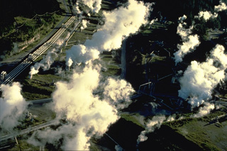 Steam rises from a geothermal plant in the Maroa caldera. The 16 x 25 km caldera formed sometime after 230,000 years ago in the NE corner of the larger Whakamaru caldera. The Maroa caldera was filled by at least 70 rhyolitic lava domes and flows. The latest dated eruption took place about 14,000 years ago at Puketarata. Large hydrothermal explosions have occurred during the Holocene, most recently about 1800 years ago at the time of a major eruption at the neighboring Taupo volcanic centre.
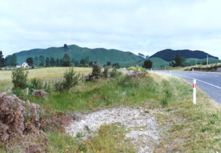 Ngangiho lava dome is one of at least 70 post-caldera lava domes erupted within the Maroa caldera, which formed sometime after about 230,000 years ago N of the Taupo caldera. The youngest of the post-caldera lava domes is Puketarata, which grew within a rhyolitic tuff ring about 14,000 years ago. The domes were erupted along a general SW-NE trend, parallel to the structural trend of the Taupo Volcanic Zone. No Holocene eruptions have occurred, but vigorous thermal activity continues.
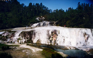 Siliceous sinter terraces located within the at Orakei Korako thermal areas in New Zealand. The thermal area lies along the Waikato River at an elevation of 260-360 m on the E side of the Maroa volcanic center. Hydrothermal explosions took place at five centers at Orakei Korako prior to the Taupo pumice eruption about 1,800 years ago, depositing explosion breccias that immediately underlie the Taupo Pumice.
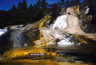 Algae colors the surface of siliceous sinter terraces at the Orakei Korako thermal area. This geothermal area is one of the principal hydrothermal fields of the Taupo Volcanic Zone. It lies on the banks of the Waikato River where the Paeroa Fault divides into smaller branches that intersect the E margin of the Maroa Volcanic Center. Orakei Korako contains sinter sheets covering an area of about 1 km2. Flooding of the river hydroelectric power generation has drowned about 70% of the hot springs.
The following 8 samples associated with this volcano can be found in the Smithsonian's NMNH Department of Mineral Sciences collections, and may be availble for research (contact the Rock and Ore Collections Manager). Catalog number links will open a window with more information.
| Catalog Number | Sample Description | Lava Source | Collection Date |
|---|---|---|---|
| NMNH 116566-10 | Volcanic Rock | WAIRAKEI | -- |
| NMNH 116566-11 | Volcanic Rock | WAIRAKEI | -- |
| NMNH 117454-37 | Perlite | -- | -- |
| NMNH 117454-38 | Perlite | -- | -- |
| NMNH 117454-39 | Obsidian | -- | -- |
| NMNH 117454-40 | Perlite | -- | -- |
| NMNH 117454-41 | Obsidian | -- | -- |
| NMNH 117454-42 | Pumice | -- | -- |
| Copernicus Browser | The Copernicus Browser replaced the Sentinel Hub Playground browser in 2023, to provide access to Earth observation archives from the Copernicus Data Space Ecosystem, the main distribution platform for data from the EU Copernicus missions. |
|
WOVOdat
Single Volcano View Temporal Evolution of Unrest Side by Side Volcanoes |
WOVOdat is a database of volcanic unrest; instrumentally and visually recorded changes in seismicity, ground deformation, gas emission, and other parameters from their normal baselines. It is sponsored by the World Organization of Volcano Observatories (WOVO) and presently hosted at the Earth Observatory of Singapore.
GVMID Data on Volcano Monitoring Infrastructure The Global Volcano Monitoring Infrastructure Database GVMID, is aimed at documenting and improving capabilities of volcano monitoring from the ground and space. GVMID should provide a snapshot and baseline view of the techniques and instrumentation that are in place at various volcanoes, which can be use by volcano observatories as reference to setup new monitoring system or improving networks at a specific volcano. These data will allow identification of what monitoring gaps exist, which can be then targeted by remote sensing infrastructure and future instrument deployments. |
| IRIS seismic stations/networks | Incorporated Research Institutions for Seismology (IRIS) Data Services map showing the location of seismic stations from all available networks (permanent or temporary) within a radius of 0.18° (about 20 km at mid-latitudes) from the given location of Maroa. Users can customize a variety of filters and options in the left panel. Note that if there are no stations are known the map will default to show the entire world with a "No data matched request" error notice. |
| UNAVCO GPS/GNSS stations | Geodetic Data Services map from UNAVCO showing the location of GPS/GNSS stations from all available networks (permanent or temporary) within a radius of 20 km from the given location of Maroa. Users can customize the data search based on station or network names, location, and time window. Requires Adobe Flash Player. |
| Large Eruptions of Maroa | Information about large Quaternary eruptions (VEI >= 4) is cataloged in the Large Magnitude Explosive Volcanic Eruptions (LaMEVE) database of the Volcano Global Risk Identification and Analysis Project (VOGRIPA). |
| EarthChem | EarthChem develops and maintains databases, software, and services that support the preservation, discovery, access and analysis of geochemical data, and facilitate their integration with the broad array of other available earth science parameters. EarthChem is operated by a joint team of disciplinary scientists, data scientists, data managers and information technology developers who are part of the NSF-funded data facility Integrated Earth Data Applications (IEDA). IEDA is a collaborative effort of EarthChem and the Marine Geoscience Data System (MGDS). |

