Acoustic data indicates possible nearby volcanic activity
Olivier Hyvernaud reported that recent T-phase waves, recorded by the Laboratoire de Géophysique in Tahiti, originated from near Curtis Island (figure 1) and had waveforms suggesting a volcanic origin. The first of these hydroacoustic waves recorded on the Polynesian seismic network were a brief swarm of seven short strong events on 17 January 2009. On that day the network received the signals between 1706 and 1717 UTC. In addition, a single event was received 19 January 2009 at 0753 UTC. The best preliminary location for these events was 30.49°S, 178.55°W, a position 5-6 km NNE of Curtis Island and well within the area of the larger caldera structure.
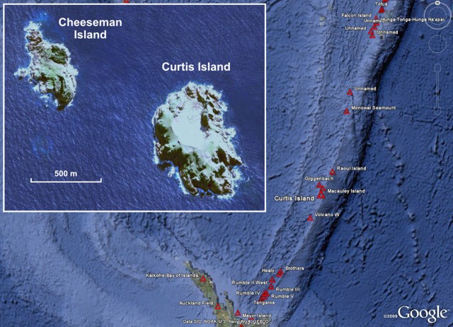 |
Figure 1. Satellite imagery showing Curtis and Cheeseman Islands (inset) along the Kermadec Island chain north of New Zealand. Curtis Island is approximately 900 km NE of New Zealand. Volcano locations from GVP database. Inset map image acquired 10-11 May 2006 by DigitalGlobe. Imagery courtesy of Google Earth. |
On the New Zealand GNS Science website there is a brief discussion and two photos of Curtis Island, noting a short visit there, thermal activity, nearby mineral-rich volcanoes, and that it lies adjacent to a chain of submarine volcanoes (eg. Smith, 1988). They also stated "The benefit in studying this remote outcrop is the insight it gives into the composition of these underwater vents, while being relatively straightforward to measure in comparison."
On 1 April 2009 Brad Scott (GNS) added that they were not aware of any activity at this time. The island is remote and GNS personnel do not visit on a regular basis. The activity on the island is solfataric. He also noted that the island is composed of pyroclastic-flow (ignimbrites) deposits from an unknown nearby source.
No thermal alerts have been measured by the MODVOLC system for Curtis Island since at least the beginning of 2004 and through 1 April 2009.
References. Smith, I., 1988, The geochemistry of rock and water samples from Curtis Island volcano, Kermadec group, southwest Pacific: Journal of Volcanology and Geothermal Research, v. 34, no. 3-4, p. 233-240.
Information Contacts: GNS Science, Wairakei Research Centre, Private Bag 2000, Taupo 3352, New Zealand (URL: http://www.gns.cri.nz/); Olivier Hyvernaud, Laboratoire de Géophysique, Commissariat a l'Energie Atomique (CEA/DASE/LDG), PO Box 640, Papeete, Tahiti, French Polynesia; Hawai'i Institute of Geophysics and Planetology (HIGP) Thermal Alerts System, School of Ocean and Earth Science and Technology (SOEST), Univ. of Hawai'i, 2525 Correa Road, Honolulu, HI 96822, USA (URL: http://modis.higp.hawaii.edu/).
The Global Volcanism Program has no Weekly Reports available for Curtis Island.
Reports are organized chronologically and indexed below by Month/Year (Publication Volume:Number), and include a one-line summary. Click on the index link or scroll down to read the reports.
Acoustic data indicates possible nearby volcanic activity
Olivier Hyvernaud reported that recent T-phase waves, recorded by the Laboratoire de Géophysique in Tahiti, originated from near Curtis Island (figure 1) and had waveforms suggesting a volcanic origin. The first of these hydroacoustic waves recorded on the Polynesian seismic network were a brief swarm of seven short strong events on 17 January 2009. On that day the network received the signals between 1706 and 1717 UTC. In addition, a single event was received 19 January 2009 at 0753 UTC. The best preliminary location for these events was 30.49°S, 178.55°W, a position 5-6 km NNE of Curtis Island and well within the area of the larger caldera structure.
|
Figure 1. Satellite imagery showing Curtis and Cheeseman Islands (inset) along the Kermadec Island chain north of New Zealand. Curtis Island is approximately 900 km NE of New Zealand. Volcano locations from GVP database. Inset map image acquired 10-11 May 2006 by DigitalGlobe. Imagery courtesy of Google Earth. |
On the New Zealand GNS Science website there is a brief discussion and two photos of Curtis Island, noting a short visit there, thermal activity, nearby mineral-rich volcanoes, and that it lies adjacent to a chain of submarine volcanoes (eg. Smith, 1988). They also stated "The benefit in studying this remote outcrop is the insight it gives into the composition of these underwater vents, while being relatively straightforward to measure in comparison."
On 1 April 2009 Brad Scott (GNS) added that they were not aware of any activity at this time. The island is remote and GNS personnel do not visit on a regular basis. The activity on the island is solfataric. He also noted that the island is composed of pyroclastic-flow (ignimbrites) deposits from an unknown nearby source.
No thermal alerts have been measured by the MODVOLC system for Curtis Island since at least the beginning of 2004 and through 1 April 2009.
References. Smith, I., 1988, The geochemistry of rock and water samples from Curtis Island volcano, Kermadec group, southwest Pacific: Journal of Volcanology and Geothermal Research, v. 34, no. 3-4, p. 233-240.
Information Contacts: GNS Science, Wairakei Research Centre, Private Bag 2000, Taupo 3352, New Zealand (URL: http://www.gns.cri.nz/); Olivier Hyvernaud, Laboratoire de Géophysique, Commissariat a l'Energie Atomique (CEA/DASE/LDG), PO Box 640, Papeete, Tahiti, French Polynesia; Hawai'i Institute of Geophysics and Planetology (HIGP) Thermal Alerts System, School of Ocean and Earth Science and Technology (SOEST), Univ. of Hawai'i, 2525 Correa Road, Honolulu, HI 96822, USA (URL: http://modis.higp.hawaii.edu/).
|
|
||||||||||||||||||||||||||
There is data available for 0 confirmed eruptive period.
[ 2009 Jan 18 - 2009 Jan 19 ] Uncertain Eruption
| Episode 1 | Uncertain | 5-6 km NNE of Curtis Island | |||||||||||||
|---|---|---|---|---|---|---|---|---|---|---|---|---|---|---|
| 2009 Jan 18 - 2009 Jan 19 | Evidence from Unknown | |||||||||||||
| Olivier Hyvernaud reported that T-phase signals were recorded by the Laboratoire de Géophysique in Tahiti, with waveforms suggesting a volcanic source, originated from near Curtis Island. The first of these hydroacoustic waves recorded on the seismic network were a brief swarm of seven short strong events between 1706 and 1717 on 17 January 2009 (UTC). In addition, a single event was received at 0753 on 19 January 2009 (UTC). The best preliminary location for these events was 30.49°S, 178.55°W, a position 5-6 km NNE of Curtis Island and well within the area of the larger caldera structure. | ||||||||||||||
|
List of 1 Events for Episode 1 at 5-6 km NNE of Curtis Island
|
||||||||||||||
[ 1936 Jun 18 - 1936 Dec ] Uncertain Eruption
| Episode 1 | Uncertain | ||||
|---|---|---|---|---|
| 1936 Jun 18 - 1936 Dec | Evidence from Unknown | |||
| On 18 June 1936 a yacht passed through water near Curtis Island discolored by a "spongy sort of sulfur" attributed to a submarine eruption. The yacht may have been as far as 70 km away from the island at the time of the June observation, sighting Macauley Island (35 km N of Curtis) two hours later, and the sulfur raft cannot unequivocably be attributed to Curtis volcano (Lloyd, 1992). In December 1936 a vessel passed through "a volcanic disturbance with clouds of sulfurous fumes" off Curtis Island (Doyle et al., 1979); the sulfurous smell detected in December is not considered to represent unusual activity. | ||||
[ 1899 ] Discredited Eruption
Dense volumes of smoke and steam were reported to be continually issuing from the crater of Curtis Island as seen from the G.S. Hinemoa (Doyle et al., 1979). This event apparently produced no noticeable changes to the crater floor and is unlikely to have resulted from an eruption (Lloyd, 1992).
The Global Volcanism Program has no synonyms or subfeatures listed for Curtis Island.
There are no samples for Curtis Island in the Smithsonian's NMNH Department of Mineral Sciences Rock and Ore collection.
| Copernicus Browser | The Copernicus Browser replaced the Sentinel Hub Playground browser in 2023, to provide access to Earth observation archives from the Copernicus Data Space Ecosystem, the main distribution platform for data from the EU Copernicus missions. |
| MIROVA | Middle InfraRed Observation of Volcanic Activity (MIROVA) is a near real time volcanic hot-spot detection system based on the analysis of MODIS (Moderate Resolution Imaging Spectroradiometer) data. In particular, MIROVA uses the Middle InfraRed Radiation (MIR), measured over target volcanoes, in order to detect, locate and measure the heat radiation sourced from volcanic activity. |
| MODVOLC Thermal Alerts | Using infrared satellite Moderate Resolution Imaging Spectroradiometer (MODIS) data, scientists at the Hawai'i Institute of Geophysics and Planetology, University of Hawai'i, developed an automated system called MODVOLC to map thermal hot-spots in near real time. For each MODIS image, the algorithm automatically scans each 1 km pixel within it to check for high-temperature hot-spots. When one is found the date, time, location, and intensity are recorded. MODIS looks at every square km of the Earth every 48 hours, once during the day and once during the night, and the presence of two MODIS sensors in space allows at least four hot-spot observations every two days. Each day updated global maps are compiled to display the locations of all hot spots detected in the previous 24 hours. There is a drop-down list with volcano names which allow users to 'zoom-in' and examine the distribution of hot-spots at a variety of spatial scales. |
|
WOVOdat
Single Volcano View Temporal Evolution of Unrest Side by Side Volcanoes |
WOVOdat is a database of volcanic unrest; instrumentally and visually recorded changes in seismicity, ground deformation, gas emission, and other parameters from their normal baselines. It is sponsored by the World Organization of Volcano Observatories (WOVO) and presently hosted at the Earth Observatory of Singapore.
GVMID Data on Volcano Monitoring Infrastructure The Global Volcano Monitoring Infrastructure Database GVMID, is aimed at documenting and improving capabilities of volcano monitoring from the ground and space. GVMID should provide a snapshot and baseline view of the techniques and instrumentation that are in place at various volcanoes, which can be use by volcano observatories as reference to setup new monitoring system or improving networks at a specific volcano. These data will allow identification of what monitoring gaps exist, which can be then targeted by remote sensing infrastructure and future instrument deployments. |
| Volcanic Hazard Maps | The IAVCEI Commission on Volcanic Hazards and Risk has a Volcanic Hazard Maps database designed to serve as a resource for hazard mappers (or other interested parties) to explore how common issues in hazard map development have been addressed at different volcanoes, in different countries, for different hazards, and for different intended audiences. In addition to the comprehensive, searchable Volcanic Hazard Maps Database, this website contains information about diversity of volcanic hazard maps, illustrated using examples from the database. This site is for educational purposes related to volcanic hazard maps. Hazard maps found on this website should not be used for emergency purposes. For the most recent, official hazard map for a particular volcano, please seek out the proper institutional authorities on the matter. |
| IRIS seismic stations/networks | Incorporated Research Institutions for Seismology (IRIS) Data Services map showing the location of seismic stations from all available networks (permanent or temporary) within a radius of 0.18° (about 20 km at mid-latitudes) from the given location of Curtis Island. Users can customize a variety of filters and options in the left panel. Note that if there are no stations are known the map will default to show the entire world with a "No data matched request" error notice. |
| UNAVCO GPS/GNSS stations | Geodetic Data Services map from UNAVCO showing the location of GPS/GNSS stations from all available networks (permanent or temporary) within a radius of 20 km from the given location of Curtis Island. Users can customize the data search based on station or network names, location, and time window. Requires Adobe Flash Player. |
| DECADE Data | The DECADE portal, still in the developmental stage, serves as an example of the proposed interoperability between The Smithsonian Institution's Global Volcanism Program, the Mapping Gas Emissions (MaGa) Database, and the EarthChem Geochemical Portal. The Deep Earth Carbon Degassing (DECADE) initiative seeks to use new and established technologies to determine accurate global fluxes of volcanic CO2 to the atmosphere, but installing CO2 monitoring networks on 20 of the world's 150 most actively degassing volcanoes. The group uses related laboratory-based studies (direct gas sampling and analysis, melt inclusions) to provide new data for direct degassing of deep earth carbon to the atmosphere. |
| Large Eruptions of Curtis Island | Information about large Quaternary eruptions (VEI >= 4) is cataloged in the Large Magnitude Explosive Volcanic Eruptions (LaMEVE) database of the Volcano Global Risk Identification and Analysis Project (VOGRIPA). |
| EarthChem | EarthChem develops and maintains databases, software, and services that support the preservation, discovery, access and analysis of geochemical data, and facilitate their integration with the broad array of other available earth science parameters. EarthChem is operated by a joint team of disciplinary scientists, data scientists, data managers and information technology developers who are part of the NSF-funded data facility Integrated Earth Data Applications (IEDA). IEDA is a collaborative effort of EarthChem and the Marine Geoscience Data System (MGDS). |


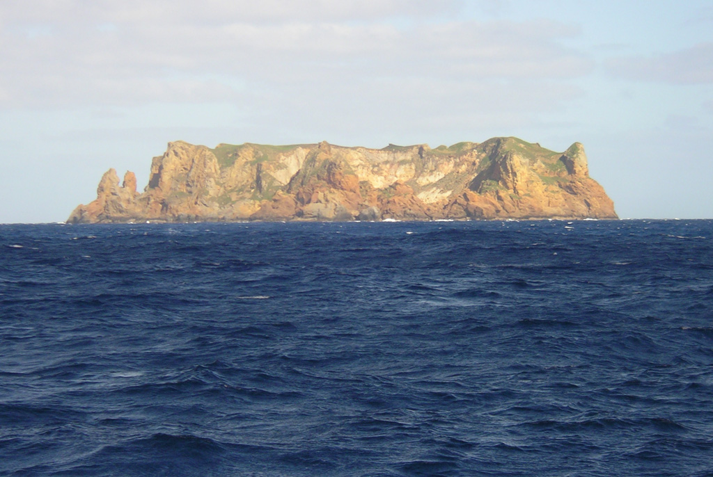
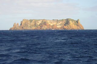 Flat-topped Curtis Island, seen here from the N, is, along with nearby Cheeseman Island, the uplifted portion of a submarine volcano astride the Kermadec Ridge. The small Pleistocene island contains abundant andesitic pyroclastic flow deposits. Reports of possible historical eruptions probably represent increased thermal activity from a shallow crater near sea level. Geologic studies have documented uplift of 18 m at Curtis during the past 200 years.