The Global Volcanism Program has no activity reports available for Aneityum.
The Global Volcanism Program has no Weekly Reports available for Aneityum.
The Global Volcanism Program has no Bulletin Reports available for Aneityum.
|
|
||||||||||||||||||||||||||
The Global Volcanism Program is not aware of any Holocene eruptions from Aneityum. If this volcano has had large eruptions (VEI >= 4) prior to 12,000 years ago, information might be found on the Aneityum page in the LaMEVE (Large Magnitude Explosive Volcanic Eruptions) database, a part of the Volcano Global Risk Identification and Analysis Project (VOGRIPA).
This compilation of synonyms and subsidiary features may not be comprehensive. Features are organized into four major categories: Cones, Craters, Domes, and Thermal Features. Synonyms of features appear indented below the primary name. In some cases additional feature type, elevation, or location details are provided.
Synonyms |
||||
| Anatom | Anetchom | ||||
Cones |
||||
| Feature Name | Feature Type | Elevation | Latitude | Longitude |
| Inrerow Atamwan | Stratovolcano | 852 m | 20° 11' 0.00" S | 169° 47' 0.00" E |
| Nanawarez | Stratovolcano | 804 m | 20° 12' 0.00" S | 169° 50' 0.00" E |
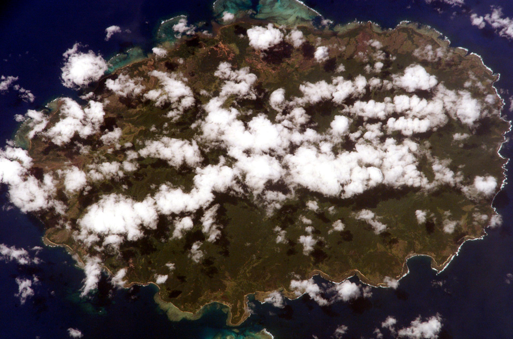
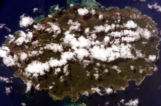 Clouds drape oval-shaped, 17-km-wide Aneityum Island in this NASA International Space Station image with north to the top. Aneityum, also known as Anatom, consists of two coalescing, dominantly basaltic Pleistocene volcanoes. Both the NW side of Inrerow Atamwan volcano (left) and the SE side of Nanawarez volcano (right) are truncated by large erosional cirques. Volcanic activity ceased during the late-Pleistocene to Holocene. Fringing reefs are visible on the northern side of the island.
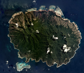 Aneityum Island is approximately 17 km long in the NE-SW direction, shown in this September 2019 Planet Labs satellite image monthly mosaic (N is at the top). Two main eroded edifices form the island, Nanawarez in the E and Inrerow Atamwan to the W, with a large horseshoe-shaped scarp that opens to the SE visible on Nanawarez.
There are no samples for Aneityum in the Smithsonian's NMNH Department of Mineral Sciences Rock and Ore collection.
| Copernicus Browser | The Copernicus Browser replaced the Sentinel Hub Playground browser in 2023, to provide access to Earth observation archives from the Copernicus Data Space Ecosystem, the main distribution platform for data from the EU Copernicus missions. |
|
WOVOdat
Single Volcano View Temporal Evolution of Unrest Side by Side Volcanoes |
WOVOdat is a database of volcanic unrest; instrumentally and visually recorded changes in seismicity, ground deformation, gas emission, and other parameters from their normal baselines. It is sponsored by the World Organization of Volcano Observatories (WOVO) and presently hosted at the Earth Observatory of Singapore.
GVMID Data on Volcano Monitoring Infrastructure The Global Volcano Monitoring Infrastructure Database GVMID, is aimed at documenting and improving capabilities of volcano monitoring from the ground and space. GVMID should provide a snapshot and baseline view of the techniques and instrumentation that are in place at various volcanoes, which can be use by volcano observatories as reference to setup new monitoring system or improving networks at a specific volcano. These data will allow identification of what monitoring gaps exist, which can be then targeted by remote sensing infrastructure and future instrument deployments. |
| IRIS seismic stations/networks | Incorporated Research Institutions for Seismology (IRIS) Data Services map showing the location of seismic stations from all available networks (permanent or temporary) within a radius of 0.18° (about 20 km at mid-latitudes) from the given location of Aneityum. Users can customize a variety of filters and options in the left panel. Note that if there are no stations are known the map will default to show the entire world with a "No data matched request" error notice. |
| UNAVCO GPS/GNSS stations | Geodetic Data Services map from UNAVCO showing the location of GPS/GNSS stations from all available networks (permanent or temporary) within a radius of 20 km from the given location of Aneityum. Users can customize the data search based on station or network names, location, and time window. Requires Adobe Flash Player. |
| Large Eruptions of Aneityum | Information about large Quaternary eruptions (VEI >= 4) is cataloged in the Large Magnitude Explosive Volcanic Eruptions (LaMEVE) database of the Volcano Global Risk Identification and Analysis Project (VOGRIPA). |
| EarthChem | EarthChem develops and maintains databases, software, and services that support the preservation, discovery, access and analysis of geochemical data, and facilitate their integration with the broad array of other available earth science parameters. EarthChem is operated by a joint team of disciplinary scientists, data scientists, data managers and information technology developers who are part of the NSF-funded data facility Integrated Earth Data Applications (IEDA). IEDA is a collaborative effort of EarthChem and the Marine Geoscience Data System (MGDS). |

