Vanuatu Volcanoes
Vanuatu has 14 Holocene volcanoes. Note that as a scientific organization we provide these listings for informational purposes only, with no international legal or policy implications. Volcanoes will be included on this list if they are within the boundaries of a country, on a shared boundary or area, in a remote territory, or within a maritime Exclusive Economic Zone. Bolded volcanoes have erupted within the past 20 years. Suggestions and data updates are always welcome ().
| Volcano Name | Last Eruption | Volcanic Region | Primary Landform |
|---|---|---|---|
| Ambae | 2024 CE | Vanuatu Volcanic Arc | Shield |
| Ambrym | 2024 CE | Vanuatu Volcanic Arc | Shield |
| East Epi | 2023 CE | Vanuatu Volcanic Arc | Cluster |
| Gaua | 2022 CE | Vanuatu Volcanic Arc | Composite |
| Gemini-Oscostar | 1996 CE | Vanuatu Volcanic Arc | Cluster |
| Hunter Island | 1903 CE | Vanuatu Volcanic Arc | Composite |
| Kuwae | 1974 CE | Vanuatu Volcanic Arc | Caldera |
| Lopevi | 2007 CE | Vanuatu Volcanic Arc | Composite |
| Matthew Island | 1956 CE | Vanuatu Volcanic Arc | Composite |
| Motlav | Unknown - Evidence Credible | Vanuatu Volcanic Arc | Composite |
| Nguna-Emau | Unknown - Evidence Credible | Vanuatu Volcanic Arc | Composite |
| Suretamatai | 1966 CE | Vanuatu Volcanic Arc | Composite |
| Traitor's Head | 1881 CE | Vanuatu Volcanic Arc | Composite |
| Yasur | 2025 CE | Vanuatu Volcanic Arc | Composite |
Chronological listing of known Holocene eruptions (confirmed or uncertain) from volcanoes in Vanuatu. Bolded eruptions indicate continuing activity.
| Volcano Name | Start Date | Stop Date | Certainty | VEI | Evidence |
|---|---|---|---|---|---|
| Ambrym | [2024 Oct 31] | [2024 Nov 2] | Uncertain | ||
| Ambae | 2024 Jun 29 | 2024 Jun 30 | Confirmed | 2 | Observations: Reported |
| Ambrym | 2024 Jan 13 | 2024 Jan 16 | Confirmed | 0 | Observations: Reported |
| Ambae | 2023 Dec 11 | 2023 Dec 21 | Confirmed | 2 | Observations: Reported |
| Ambae | 2023 Feb 20 | 2023 May 28 | Confirmed | 2 | Observations: Reported |
| East Epi | 2023 Jan 31 | 2023 Feb 23 | Confirmed | 1 | Observations: Reported |
| Gaua | 2022 May 3 | 2022 May 3 | Confirmed | 1 | Observations: Reported |
| Ambrym | 2022 Jan 25 | 2022 Feb 2 ± 1 days | Confirmed | 1 | Observations: Reported |
| Ambae | 2021 Dec 5 | 2022 Aug 15 ± 10 days | Confirmed | 1 | Observations: Reported |
| Gaua | 2021 Nov 16 | 2021 Nov 16 | Confirmed | 1 | Observations: Reported |
| Ambae | 2017 Sep 6 | 2018 Oct 30 (?) | Confirmed | 3 | Observations: Reported |
| Ambae | [2016 Aug 18] | [2016 Aug 19] | Uncertain | ||
| Lopevi | [2014 Dec 1] | [2014 Dec 15] | Uncertain | ||
| Gaua | 2011 Sep 17 | 2011 Oct 10 | Confirmed | 1 | Observations: Reported |
| Ambae | 2011 Jun 4 | 2011 Jul 10 | Confirmed | 1 | Observations: Reported |
| Gaua | 2009 Sep 27 | 2010 Jun 19 | Confirmed | 2 | Observations: Reported |
| Ambrym | 2008 May 23 | 2018 Dec 17 | Confirmed | 2 | Observations: Reported |
| Lopevi | [2008 Feb 24] | [2008 Feb 24 (?)] | Uncertain | ||
| Lopevi | 2007 Apr 21 | 2007 May 14 (?) | Confirmed | 2 | Observations: Reported |
| Ambrym | 2006 Nov 8 | 2007 Dec 27 (on or after) | Confirmed | 2 | Observations: Reported |
| Ambae | 2005 Nov 27 | 2006 Feb 16 ± 15 days | Confirmed | 2 | Observations: Reported |
| Lopevi | 2005 Oct 27 (?) | 2006 Aug 1 (?) | Confirmed | 2 | Observations: Reported |
| Lopevi | 2005 Jan 30 | 2005 Mar 31 (?) | Confirmed | 2 | Observations: Reported |
| Lopevi | 2004 Sep 16 ± 15 days | 2004 Sep 16 ± 15 days | Confirmed | 2 | Observations: Reported |
| East Epi | 2004 Feb 16 | 2004 Feb 24 | Confirmed | 2 | Observations: Reported |
| Lopevi | 2003 Jun 8 | 2003 Jun 16 (?) | Confirmed | 3 | Observations: Reported |
| East Epi | 2002 Mar 16 ± 15 days | 2002 Mar 16 ± 15 days | Confirmed | 1 | Observations: Reported |
| Lopevi | 2001 Jun 8 | 2001 Jun 19 (on or after) | Confirmed | 3 | Observations: Reported |
| East Epi | 1999 Feb 1 ± 30 days | 1999 Feb 1 ± 30 days | Confirmed | 1 | Observations: Reported |
| Lopevi | 1998 Jul 16 ± 15 days | 2000 Apr 25 (?) | Confirmed | 3 | Observations: Reported |
| Ambrym | 1996 Jun 16 (on or before) ± 15 days | 2005 Aug 16 (on or after) ± 15 days | Confirmed | 1 | Observations: Reported |
| Gemini-Oscostar | 1996 Feb 18 | 1996 Feb 22 (on or after) | Confirmed | 1 | Observations: Reported |
| Ambae | 1995 Mar 2 | 1995 Mar 3 (?) | Confirmed | 2 | Observations: Reported |
| Ambrym | 1994 Dec 16 (on or before) ± 15 days | Unknown | Confirmed | 1 | Observations: Reported |
| Ambrym | 1990 Sep 16 (on or before) ± 15 days | 1991 Jul 16 (on or after) ± 15 days | Confirmed | 2 | Observations: Reported |
| Ambrym | 1989 Apr 24 | 1989 Dec 23 | Confirmed | 2 | Observations: Reported |
| East Epi | [1988 Aug 16 ± 15 days] | [Unknown] | Uncertain | ||
| Ambrym | 1988 Feb 12 (?) | 1988 Aug 23 | Confirmed | 3 | Observations: Reported |
| Ambrym | 1986 Nov 13 | 1986 Nov 19 (?) | Confirmed | 2 | Observations: Reported |
| Ambrym | 1984 Jul 2 ± 182 days | 1986 Mar 8 (on or after) | Confirmed | 2 | Observations: Reported |
| Ambrym | 1983 Jul 2 ± 182 days | Unknown | Confirmed | 2 | Observations: Reported |
| Lopevi | 1982 Oct 24 | 1982 Oct 25 | Confirmed | 2 | Observations: Reported |
| Gaua | 1982 Apr 18 | 1982 Apr 18 | Confirmed | 2 | Observations: Reported |
| Gaua | 1981 Jul 9 | 1981 Jul 9 | Confirmed | 1 | Observations: Reported |
| Ambrym | 1981 Feb 20 | 1981 Sep 30 | Confirmed | 2 | Observations: Reported |
| Kuwae | [1980 Aug 20] | [Unknown] | Uncertain | ||
| Gaua | 1980 Jul 2 ± 182 days | Unknown | Confirmed | 1 | Observations: Reported |
| Ambrym | 1980 May 16 | 1980 Aug 18 | Confirmed | 3 | Observations: Reported |
| Lopevi | 1980 Apr 15 | 1980 Aug 20 | Confirmed | 3 | Observations: Reported |
| Kuwae | [1979 Sep 16 ± 15 days] | [Unknown] | Uncertain | ||
| Lopevi | 1979 Jul 2 | 1979 Sep 12 | Confirmed | 2 | Observations: Reported |
| East Epi | 1979 Jul 2 ± 5 years ± 182 days | Unknown | Confirmed | 0 | Observations: Reported |
| Ambrym | 1979 Jun 6 | 1979 Sep 16 (?) ± 15 days | Confirmed | 2 | Observations: Reported |
| Ambrym | 1979 Jan 26 ± 5 days | 1979 Feb 18 (?) | Confirmed | 2 | Observations: Reported |
| Lopevi | 1978 Nov 22 | 1979 Mar 16 ± 15 days | Confirmed | 2 | Observations: Reported |
| Ambrym | 1977 Aug 16 ± 15 days | 1977 Sep 30 | Confirmed | 2 | Observations: Reported |
| Gaua | 1977 Apr 13 | 1977 Apr 13 | Confirmed | 2 | Observations: Reported |
| Kuwae | [1977 Feb 1] | [Unknown] | Uncertain | ||
| Ambrym | 1977 Jan 20 ± 5 days | 1977 Jan 28 (?) | Confirmed | 2 | Observations: Reported |
| Matthew Island | [1976 Nov 27] | [Unknown] | Uncertain | ||
| Lopevi | 1976 May 1 | 1976 Sep 5 | Confirmed | 1 | Observations: Reported |
| Gaua | 1976 Jan 15 ± 5 days | Unknown | Confirmed | 2 | Observations: Reported |
| Lopevi | 1975 Mar 6 ± 3 days | 1975 Jun 23 | Confirmed | 2 | Observations: Reported |
| East Epi | [1974 Nov 16 ± 15 days] | [1974 Nov 16 ± 15 days] | Uncertain | ||
| Kuwae | 1974 Feb 4 ± 4 days | 1974 Sep 16 (?) ± 15 days | Confirmed | 0 | Observations: Reported |
| Lopevi | 1974 Jan 16 ± 15 days | 1974 Oct 7 | Confirmed | 2 | Observations: Reported |
| Gaua | 1973 Oct 9 | 1974 Jan 21 | Confirmed | 2 | Observations: Reported |
| East Epi | [1973 May 5 ± 4 days] | [1973 Oct 26 ± 5 days] | Uncertain | ||
| Kuwae | [1973 May 5 ± 4 days] | [1973 Oct 16 ± 15 days] | Uncertain | ||
| Ambrym | 1973 Apr 15 ± 5 days | 1976 Oct 14 | Confirmed | 3 | Observations: Reported |
| East Epi | [1972 May 15 ± 5 days] | [1972 Jun 25 ± 5 days] | Uncertain | ||
| Ambrym | 1972 Apr 15 | 1972 Aug 15 | Confirmed | 3 | Observations: Reported |
| Kuwae | [1972 Mar 5 ± 5 days] | [1972 May 15 ± 5 days] | Uncertain | ||
| East Epi | [1971 Oct 28] | [1971 Nov 15 (?)] | Uncertain | ||
| Gaua | 1971 May 12 | 1971 May 13 | Confirmed | 2 | Observations: Reported |
| Kuwae | 1971 Feb 22 | 1971 Feb 22 | Confirmed | 2 | Observations: Reported |
| Ambrym | 1971 Feb 3 | 1971 Nov 5 | Confirmed | 2 | Observations: Reported |
| Kuwae | [1970 Sep 12] | [1970 Sep 20] | Uncertain | ||
| Lopevi | 1970 May 9 | 1972 Aug 7 | Confirmed | 2 | Observations: Reported |
| Gaua | 1969 Sep 22 | Unknown | Confirmed | 2 | Observations: Reported |
| Gaua | 1968 Jul 2 ± 182 days | 1968 Dec 1 ± 30 days | Confirmed | 2 | Observations: Reported |
| Gaua | 1967 Jul 16 ± 15 days | Unknown | Confirmed | 2 | Observations: Reported |
| Ambrym | 1967 Jul 16 ± 15 days | 1970 Aug 29 | Confirmed | 2 | Observations: Reported |
| Lopevi | 1967 Jan 27 | 1969 Mar 31 | Confirmed | 3 | Observations: Reported |
| Matthew Island | [1966 Aug 16 ± 15 days] | [Unknown] | Uncertain | ||
| Gaua | 1966 Jul 2 ± 182 days | Unknown | Confirmed | 2 | Observations: Reported |
| Gaua | 1965 Sep 27 | 1965 Sep 30 (on or after) | Confirmed | 3 | Observations: Reported |
| Suretamatai | 1965 Aug 9 | 1966 Jul 2 ± 182 days | Confirmed | 2 | Observations: Reported |
| Ambrym | 1964 Feb 16 (?) ± 15 days | 1966 Sep 16 (on or after) ± 15 days | Confirmed | 2 | Observations: Reported |
| Gaua | 1963 Sep 15 ± 5 days | 1963 Nov 9 (on or after) | Confirmed | 2 | Observations: Reported |
| Matthew Island | [1963 Sep 11] | [1964 Jul 2 ± 182 days] | Uncertain | ||
| Ambrym | 1963 Aug 30 | 1963 Sep 23 (on or after) | Confirmed | 2 | Observations: Reported |
| Lopevi | 1963 Jul 7 | 1965 Jul 2 ± 182 days | Confirmed | 3 | Observations: Reported |
| Lopevi | 1962 Jul 16 ± 15 days | 1962 Jul 16 (?) ± 15 days | Confirmed | 0 | Observations: Reported |
| Gaua | 1962 Jul 16 (on or before) ± 15 days | Unknown | Confirmed | 2 | Observations: Reported |
| Ambrym | 1961 Aug 15 | 1963 Apr 3 | Confirmed | 3 | Observations: Reported |
| Ambrym | 1960 Sep 17 | Unknown | Confirmed | 1 | Observations: Reported |
| East Epi | 1960 Jul 16 (?) ± 15 days | Unknown | Confirmed | 0 | Observations: Reported |
| Lopevi | 1960 Jul 10 | 1960 Sep 16 ± 15 days | Confirmed | 3 | Observations: Reported |
| Kuwae | 1959 Sep 18 (?) | 1959 Sep 20 (?) | Confirmed | 2 | Observations: Reported |
| Traitor's Head | [1959 Jul 2 ± 182 days] | [Unknown] | Uncertain | ||
| Ambrym | 1959 Apr 16 ± 15 days | Unknown | Confirmed | 2 | Observations: Reported |
| Ambrym | 1958 Nov 18 | Unknown | Confirmed | 2 | Observations: Reported |
| Kuwae | 1958 Oct 7 (?) | 1958 Dec 18 | Confirmed | 2 | Observations: Reported |
| East Epi | 1958 Sep 16 (?) ± 15 days | 1958 Nov 16 (?) ± 15 days | Confirmed | 2 | Observations: Reported |
| Ambrym | 1957 Aug 26 ± 5 days | 1957 Oct 16 ± 15 days | Confirmed | 1 | Observations: Reported |
| Matthew Island | 1956 Jul 2 ± 2 years ± 182 days | Unknown | Confirmed | 0 | Observations: Reported |
| Ambrym | 1955 Jul 2 ± 182 days | Unknown | Confirmed | 2 | Observations: Reported |
| Matthew Island | 1954 Oct 16 (?) ± 15 days | Unknown | Confirmed | 2 | Observations: Reported |
| Ambrym | 1954 Jul 2 ± 182 days | Unknown | Confirmed | 2 | Observations: Reported |
| East Epi | [1953 Nov 16 ± 15 days] | [Unknown] | Uncertain | ||
| Ambrym | 1953 May 16 ± 15 days | 1953 Oct 13 (?) | Confirmed | 2 | Observations: Reported |
| East Epi | 1953 Feb 12 | 1953 Feb 19 | Confirmed | 3 | Observations: Reported |
| Kuwae | 1953 Feb 12 | Unknown | Confirmed | 1 | Observations: Reported |
| Kuwae | 1952 Oct 3 | 1952 Oct 3 | Confirmed | 1 | Observations: Reported |
| Ambrym | 1952 Aug 10 | 1952 Dec 26 ± 5 days | Confirmed | 2 | Observations: Reported |
| Ambrym | 1950 Dec 6 | 1951 Nov 25 ± 5 days | Confirmed | 4 | Observations: Reported |
| Kuwae | 1949 Oct | 1949 Dec | Confirmed | 3 | Observations: Reported |
| Kuwae | 1949 Apr | Unknown | Confirmed | 3 | Observations: Reported |
| Matthew Island | 1949 (in or before) | Unknown | Confirmed | 2 | Observations: Reported |
| Kuwae | 1948 Sep 22 | 1948 Sep 29 | Confirmed | 2 | Observations: Reported |
| Ambrym | 1942 Jun 6 | Unknown | Confirmed | 2 | Observations: Reported |
| Lopevi | 1939 Nov 1 | Unknown | Confirmed | 2 | Observations: Reported |
| Lopevi | 1939 Feb 2 | Unknown | Confirmed | 2 | Observations: Reported |
| Ambrym | 1938 | Unknown | Confirmed | 2 | Observations: Reported |
| Ambrym | 1937 Mar 27 | 1937 Apr | Confirmed | 2 | Observations: Reported |
| Ambrym | 1935 Sep | 1936 Jan | Confirmed | 2 | Observations: Reported |
| Lopevi | 1933 | Unknown | Confirmed | Observations: Reported | |
| Ambrym | 1929 Jun 28 | 1929 Jul 1 | Confirmed | 2 | Observations: Reported |
| Kuwae | 1923 | 1925 | Confirmed | 2 | Observations: Reported |
| Lopevi | 1922 Jun 28 | 1922 Jul 1 | Confirmed | 2 | Observations: Reported |
| East Epi | 1920 Jan 22 | Unknown | Confirmed | 2 | Observations: Reported |
| Ambrym | 1915 Oct 20 | Unknown | Confirmed | 2 | Observations: Reported |
| Ambae | [1915 ± 1 years] | [Unknown] | Uncertain | ||
| Ambrym | 1913 Oct 14 | 1914 | Confirmed | 3 | Observations: Reported |
| Ambrym | 1912 | Unknown | Confirmed | Observations: Reported | |
| Ambrym | 1910 | Unknown | Confirmed | 0 | Observations: Reported |
| Ambrym | 1909 Jul 28 (?) | Unknown | Confirmed | 2 | Observations: Reported |
| Ambrym | 1908 | Unknown | Confirmed | 2 | Observations: Reported |
| Lopevi | 1908 | Unknown | Confirmed | 2 | Observations: Reported |
| Hunter Island | 1903 | Unknown | Confirmed | 0 | Observations: Reported |
| Lopevi | 1898 Jun 3 | 1898 Jul 24 (?) | Confirmed | 2 | Observations: Reported |
| Ambrym | 1898 Mar 26 | Unknown | Confirmed | 1 | Observations: Reported |
| Kuwae | 1897 May 25 (?) | 1901 | Confirmed | 1 | Observations: Reported |
| Hunter Island | 1895 Nov 24 | Unknown | Confirmed | Observations: Reported | |
| Ambrym | 1894 Oct 15 | 1895 Feb 10 (on or after) | Confirmed | 3 | Observations: Reported |
| Lopevi | 1892 Oct | 1893 | Confirmed | 2 | Observations: Reported |
| Hunter Island | [1892] | [Unknown] | Uncertain | ||
| Ambrym | 1888 Feb 24 ± 4 days | 1888 Apr (?) | Confirmed | 2 | Observations: Reported |
| Ambrym | 1886 Jul | Unknown | Confirmed | 2 | Observations: Reported |
| Ambrym | 1884 | Unknown | Confirmed | 2 | Observations: Reported |
| Ambrym | 1883 | Unknown | Confirmed | 2 | Observations: Reported |
| Lopevi | 1883 | 1884 | Confirmed | Observations: Reported | |
| Traitor's Head | 1881 | Unknown | Confirmed | 0 | Observations: Reported |
| Lopevi | 1874 | Unknown | Confirmed | 2 | Observations: Reported |
| Ambrym | 1871 | Unknown | Confirmed | 2 | Observations: Reported |
| Ambrym | [1870] | [Unknown] | Uncertain | ||
| Ambae | 1870 (?) | Unknown | Confirmed | 2 | Observations: Reported |
| Lopevi | 1864 Jun 9 | Unknown | Confirmed | 3 | Observations: Reported |
| Lopevi | 1863 | Unknown | Confirmed | 2 | Observations: Reported |
| Ambrym | 1863 | 1864 | Confirmed | 2 | Observations: Reported |
| Suretamatai | 1861 (?) | Unknown | Confirmed | 2 | Observations: Reported |
| Suretamatai | 1856 (?) | Unknown | Confirmed | 2 | Observations: Reported |
| Hunter Island | 1841 Mar 15 | Unknown | Confirmed | Observations: Reported | |
| Suretamatai | [1841] | [Unknown] | Uncertain | ||
| Hunter Island | 1835 | Unknown | Confirmed | Observations: Reported | |
| Matthew Island | [1828 Jan] | [Unknown] | Uncertain | ||
| Ambrym | 1820 (?) | Unknown | Confirmed | Observations: Reported | |
| Hunter Island | [1797] | [Unknown] | Uncertain | ||
| Ambrym | 1774 Jul 2 ± 182 days | Unknown | Confirmed | 2 | Observations: Reported |
| Ambae | 1670 (?) | Unknown | Confirmed | 2 | Correlation: Anthropology |
| Ambae | 1530 (?) | Unknown | Confirmed | Isotopic: 14C (uncalibrated) | |
| Kuwae | 1425 ± 5 years | Unknown | Confirmed | Isotopic: 14C (calibrated) | |
| Yasur | 1270 ± 110 years | 2025 Sep 19 (continuing) | Confirmed | 3 | Isotopic: 14C (calibrated) |
| Yasur | 0708 ± 169 years | 1273 ± 111 years | Confirmed | Isotopic: 14C (calibrated) | |
| Yasur | 0434 ± 90 years | Unknown | Confirmed | Isotopic: 14C (calibrated) | |
| Ambrym | 0050 ± 100 years | Unknown | Confirmed | 6 | Isotopic: 14C (uncalibrated) |
Vanuatu has 19 Pleistocene volcanoes. Note that as a scientific organization we provide these listings for informational purposes only, with no international legal or policy implications. Volcanoes will be included on this list if they are within the boundaries of a country, on a shared boundary or area, in a remote territory, or within a maritime Exclusive Economic Zone. Suggestions and data updates are always welcome ().
| Volcano Name | Volcanic Region | Primary Landform |
|---|---|---|
| Aneityum | Vanuatu Volcanic Arc | Composite |
| East Tanna | Vanuatu Volcanic Arc | Composite |
| Melkum | Vanuatu Volcanic Arc | Composite |
| Mere Lava | Vanuatu Volcanic Arc | Composite |
| Merig | Vanuatu Volcanic Arc | Composite |
| Mota | Vanuatu Volcanic Arc | Composite |
| Northeast Shepherd Islands | Vanuatu Volcanic Arc | Composite |
| Northern Efate | Vanuatu Volcanic Arc | Cluster |
| Northwest Shepherd Islands | Vanuatu Volcanic Arc | Composite |
| Paama Island | Vanuatu Volcanic Arc | Composite |
| Pomare | Vanuatu Volcanic Arc | Composite |
| Pumpan | Vanuatu Volcanic Arc | Composite |
| Southern Shepherd Islands | Vanuatu Volcanic Arc | Composite |
| Tavani Ruro | Vanuatu Volcanic Arc | Composite |
| Tongoa | Vanuatu Volcanic Arc | Composite |
| Unnamed | Vanuatu Volcanic Arc | Composite |
| Ureparapara | Vanuatu Volcanic Arc | Composite |
| Volsmar | Vanuatu Volcanic Arc | Cluster |
| William | Vanuatu Volcanic Arc | Composite |
There are 55 photos available for volcanoes in Vanuatu.
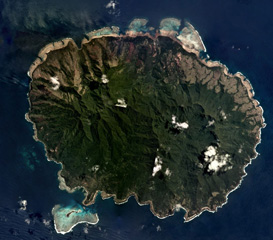
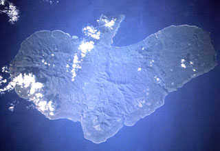
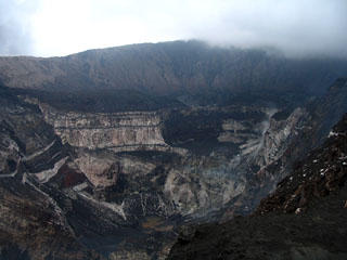
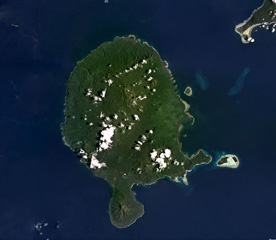
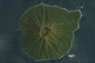
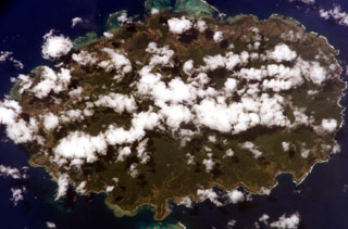
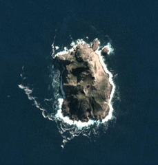 The roughly 1.1 x 0.8 km Hunter Island in the SE New Hebrides arc is shown in this 14 May 2020 PlanetScope satellite image (N is at the top). Several craters have formed across the island and geothermal activity has been noted on the N, NE, and SE coasts.
Satellite image courtesy of Planet Labs Inc., 2020 (https://www.planet.com/).
 A plume rises above the summit crater of Yasur, seen here from the west across Lake Siwi in 1988. Yasur has produced near-continuous Strombolian activity since at least 1774 and this style of activity may have continued for the past 800 years. The mostly-unvegetated cone is has a 400-m-wide summit crater.
Photo by Ian Nairn, 1988 (New Zeland Geological Survey).
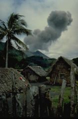 An ash cloud rising above the summit crater of Yasur volcano is seen from a village on Tanna Island in 1982. Yasur, the best-known and most frequently visited of the Vanuatu volcanoes, has been in more-or-less continuous strombolian activity since Captain Cook observed ash eruptions in 1774.
Copyrighted photo by André Demaison, 1982 (courtesy of Katia and Maurice Krafft).
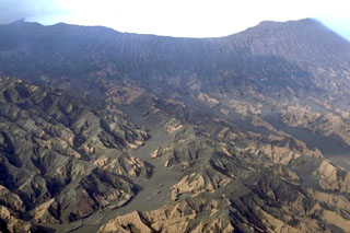
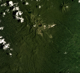
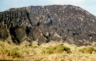 The ash-mantled slopes of the northern side of Marum cone are cut by erosional furrows. Marum is one of several historically active cones constructed within the 12-km-wide caldera of Ambrym. The cone lies in the west-central part of the caldera and is the highest of the post-caldera cones.
Photo by Alain Melchior.
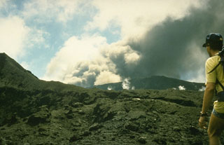
 A plume is emitted from the active crater on the NW flank of Lopevi volcano in January 1999, six months after eruptive activity resumed in July 1998. The eruption took place within the elongated 1963 crater on the upper NW flank. A small lava flow erupted in December 1998 from the smaller cone onto the crater floor to the SE.
Photo by J-M Bore, 1999 (Institut de Recherche pour le Développement, Vanuatu).
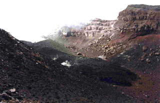
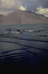
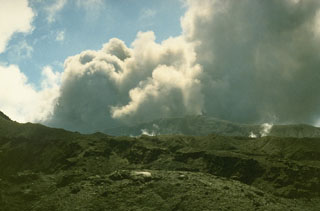
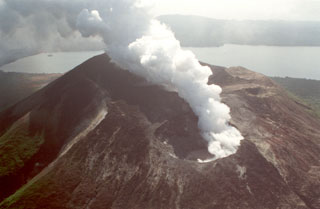
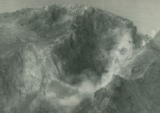
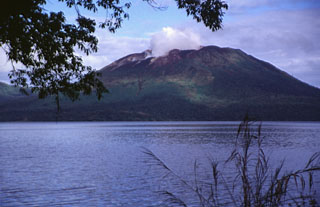 A plume rises from the active crater of Mount Garat in this view across Lake Letas, within the 6 x 9 km summit caldera of Gaua volcano (also known as Santa Maria). Three craters are located at the top of Mount Garat. The onset of eruptive activity from a vent high on the SE flank in 1962 ended a long period of dormancy.
Photo by John Seach, 1999.
 The 40-km-wide volcanic Guaya Island contains Lake Letas within a 6 x 8 km caldera in the center of this September 2019 Planet Labs satellite image monthly mosaic (N is at the top). The active Mount Garet formed within the caldera and has two summit craters; explosive eruptive activity occurred from the SE crater in 2009-2010. Smaller cones and lava flows have formed across the flanks.
Satellite image courtesy of Planet Labs Inc., 2019 (https://www.planet.com/).
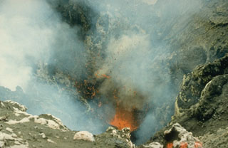
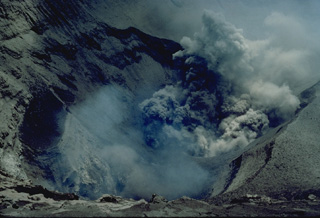
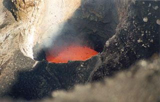
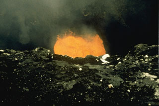
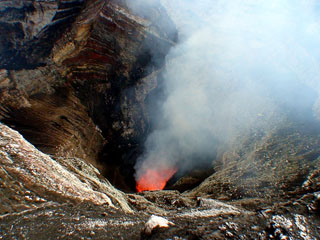 A lava lake is visible inside Mbwelesu crater within Marum cone at Ambrym on 7 June 2007. Lava lake activity was observed during a field expedition from May to June. MODIS thermal alerts had resumed at Ambrym since November 2006 and eruptions took place in April and March 2007.
Photo by Steven Clegg, 2007.
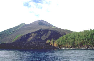
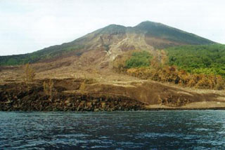
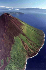
 Lopevi is seen here in an aerial view from the NW, with lava flows that erupted from NW-SE-trending fissures forming the barren slopes in the foreground. The small 7-km-wide island is known locally as Vanei Vollohulu. Historical eruptions date back to the mid-19th century. The island was evacuated following major eruptions in 1939 and 1960.
 Photo by Karoly Nemeth, 2005 (Massey University).
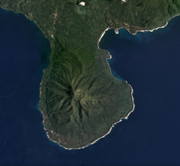
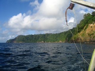 The forested cliff marks the upper caldera wall of the largely-submarine Kuwae caldera between Epi and Tongoa islands. The 6 x 12 km caldera contains two basins that cut the NW end of Tongoa Island and the flank of the late-Pleistocene or Holocene Tavani Ruru volcano on the SE tip of Epi Island. The Karua volcano lies near the northern rim of the caldera. It has formed several ephemeral islands since it was first observed in eruption during 1897.
Photo by Karoly Nemeth, 2005 (Massey University).
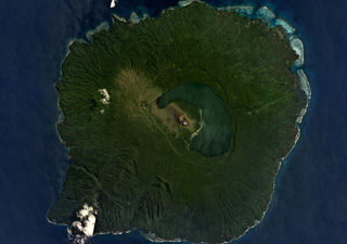
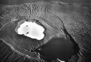
 Two lakes of variable color lie with the summit caldera of Ambae volcano, as seen in this view from the W. The light blue lake in the foreground is Lake Voui (or Vui), which is enclosed in the crater of a tuff ring within the summit caldera. The dark blue Lake Manaro Lakua lies between the tuff ring and the E caldera wall. Ambae, the most voluminous volcano of the New Hebrides archipelago, forms a 16 x 38 km island. Pentecost Island appears in the background.
Photo by Karoly Nemeth, 2005 (Massey University).
 Nguna Island, along with Pele and Emau Islands, lie north of Efate Island (also known as Vate). Submarine calderas of varying dimensions have been hypothesized to occur in the North Vate area, and late-Pleistocene to Holocene eruptions have constructed cones with well-preserved craters.
Photo by Karoly Nemeth (Massey University).
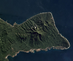
 Motlav or Mota Lava island is part of the Vanuatu northern Banks Islands, shown in this April 2019 Planet Labs satellite image monthly mosaic (N is at the top; this image is approximately 12 km across). The NE-SW central ridge contains eroded late Pleistocene eruptive centers. Two younger cones are visible here, Tuntog near the center of this image and Vetman to the SW.
Satellite image courtesy of Planet Labs Inc., 2019 (https://www.planet.com/).
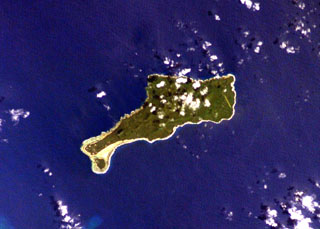
 The southern two-thirds of Vanua Lava Island is seen in this NASA International Space Station image. Suretamatai volcano forms much of the island, with the most recent activity occurring in the northern part of the island near the area with small clouds at the top of the image. The Pleistocene Ngéré Kwon volcano forms the peninsula at the bottom of the image, and small offshore islands to the right are uplifted reef limestones. Activity that began during the 19th century has consisted of moderate explosive eruptions.
NASA International Space Station image ISS006-E-40035, 2003 (http://eol.jsc.nasa.gov/).
 The dark lava flow lobe extending diagonally across the 1963 crater floor from the upper left is the December 1998 Lopevi intracrater lava flow (seen from the SE) after eruptive activity had resumed. The flow, ~100 m long and 10 m wide, originated from the small cone seen steaming at the upper left.
 Photo by Michel Lardy, 1998 (Institut de Recherche pour la Développment, Vanuatu).
 During 5-18 September 1990 Ambrym was observed to be ejecting ash and blocks from Niri Mbwelesu crater, which formed adjacent to Mbwelesu crater in 1989 when Mbwelesu was also active. It no longer contained an active lava lake. Mbwelesu, Niri Mbwelesu, and Niri Mbwelesu Taten craters remained almost constantly active into 1991.
Photo by Michel Lardy, 1990 (ORSTROM, Vanuatu).
 Erosional gullies in fresh tephra deposits across the northern slopes of Benbow, one of the tuff cones in the Ambrym summit caldera. The 12-km-wide caldera formed during a major Plinian eruption with dacitic pyroclastic flows about 1,900 years ago. Post-caldera eruptions, primarily from the Marum and Benbow cones, have partially filled the caldera floor and produced lava flows that ponded on the caldera floor or overflowed through gaps in the caldera rim.
Copyrighted photo by Marco Fulle, 2000 (Stromboli On-Line, http://stromboli.net).
 Incandescent spatter is ejected from a vent in the summit crater of Yasur volcano on 8 September 1988. The volcano has produced continuous Strombolian or Vulcanian activity since at least 1774. The mild activity seen here is occasionally interrupted by more violent explosive activity, such as during 1878, 1968, 1972, 1974-75, and 1977.
Photo by Ian Nairn, 1988 (New Zealand Geological Survey).
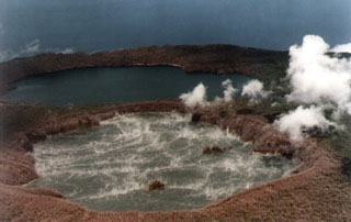 The summit of Ambae is seen looking approximately SE, with Lake Voui (foreground) and Lake Manaro Lakua (also known as Manaro Ngoru) on 20 March 1995. This was following an eruption on 2 March when bubbling and black sediment ejection were observed; the next day a 3-km-high steam-and-ash plume ejected lake sediments. Convection cells ~300-400 m in diameter can be seen in Lake Voui. The eruption took place near the center of the lake, between the two small islands. No eruptive activity was observed after 3 March.
Photo courtesy of ORSTOM, 1995 (published in Global Volcanism Program Bulletin).
 Lava flows erupted in 2000 from vents on the lower NW flank of Lopevi volcano and flowed into the sea. Many historical eruptions have occurred along the same NW-SE-trending fissure that cuts across the island, and the lava flows along this fissure near the summit also erupted in 2000.
Copyrighted photo by Marco Fulle, 2000 (Stromboli On-Line, http://stromboli.net).
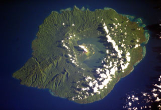
 An aerial overflight during World War II shows the summit of Ambae volcano from the SE. A broad cone containing three crater lakes is located at the summit within the youngest of at least two nested calderas. Post-caldera explosive eruptions formed the summit crater of Lake Voui (the light-colored lake) about 360 years ago. Lake Manaro Lakua at the lower right (also known as Manaro Ngoru) is alongside the eastern caldera wall.
Photo by U.S. Air Force (courtesy of Claude Robin, ORSTOM; Bull. Global Volcanism Network, 1995).
 The northern part of the Efate island group in Vanuatu is shown in this September 2019 Planet Labs satellite image monthly mosaic (N is at the top; this image is approximately 22 km across). The three smaller islands are Nguna to the NW, immediately SE of that is Pele, and the island to the E is Emau. Several craters are visible on the islands, with a 900-m-wide crater on Emau.
Satellite image courtesy of Planet Labs Inc., 2019 (https://www.planet.com/).
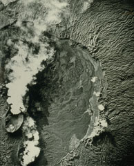
 Crescent-shaped Lake Letas partially fills the summit caldera of Gaua volcano, curving around the historically active post-caldera Mount Garat. Several young lava flows from flank vents reached the coast and form the smoother areas along the flanks of the volcano. The 6 x 9 km caldera is bound by a series of discontinuous, bifurcating faults. The dissected terrain on the SW (lower left) is part of an older series of tuff cones and lavas.
NASA International Space Station image ISS006-E-40036, 2003 (http://eol.jsc.nasa.gov/).
 Aneityum Island is approximately 17 km long in the NE-SW direction, shown in this September 2019 Planet Labs satellite image monthly mosaic (N is at the top). Two main eroded edifices form the island, Nanawarez in the E and Inrerow Atamwan to the W, with a large horseshoe-shaped scarp that opens to the SE visible on Nanawarez.
Satellite image courtesy of Planet Labs Inc., 2019 (https://www.planet.com/).
 The 5-km-wide southern peninsula of Vanua Lava Island, Vanuatu, is seen in this 2018 Planet Labs satellite image monthly mosaic (N is at the top). The Pleistocene Ngere Kwon volcano formed this area, which has since been deeply eroded.
Satellite image courtesy of Planet Labs Inc., 2018 (https://www.planet.com/).
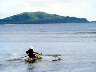
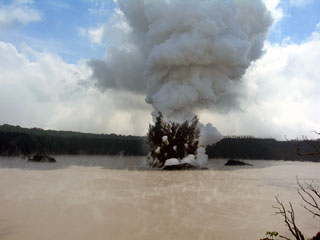
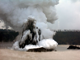
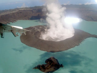
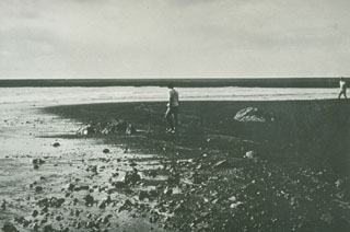 Ten days after a new island formed during a one-day submarine eruption in 1971, scientists investigate the surface of the new land. Ash plumes had been ejected to a height of 1 km. A low island 70 x 200 m had formed, with its block-littered surface one meter above high tide level. The Karua submarine volcano was constructed within the 6 x 12 km Kuwae caldera.
Photo courtesy Geological Survey, New Hebrides, 1971.
 An ash column is ejected from one of several vents on the floor of the summit crater of Yasur volcano in 1982. The frequent eruptions of this volcano have drawn visitors to Tanna Island.
Copyrighted photo by André Demaison, 1982 (courtesy of Katia and Maurice Krafft).
 Clots of incandescent magma ejected from a vent on the floor of the summit crater of Yasur volcano rise to the height of the crater rim. The more-or-less continual low-level eruptive activity of Yasur, which has been occurring since it was first observed by Captain Cook in 1774, has drawn visitors to the island of Tanna. Mild strombolian eruptions are occasionally punctuated by more violent explosions.
Copyrighted photo by André Demaison, 1982 (courtesy of Katia and Maurice Krafft).
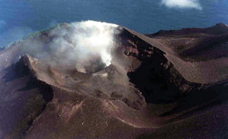
 This vertical aerial photo shows part of the 12-km-wide summit caldera of Ambrym. The craters emitting plumes to the lower left are Marum (top) and Benbow (bottom). The caldera formed during a major Plinian eruption that included pyroclastic flows about 1,900 years ago. Post-caldera eruptions, primarily from Marum and Benbow cones, have partially filled the caldera floor and also formed a series of cones and maars along a fissure system oriented ENE-WSW.
Photo by Royal Air Force (published in Green and Short, 1971).
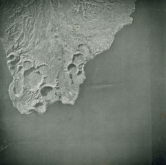
 The peninsula at the top of this Space Shuttle image of Erromango Island (N is approximately to the left) is the Traitor's Head Peninsula. Three Holocene cones at Traitor's Head are the youngest on the 50-km-long island. The volcanoes initially formed an offshore island that later joined the mainland through uplift. The only documented activity at Erromango was a submarine vent that erupted in 1881.
NASA Space Shuttle image STS68-220-4, 1994 (http://eol.jsc.nasa.gov/).
 Incandescent spatter ejected from a new lava lake at vent C of Mbwelesu crater at Ambrym volcano on 28 August 1999. Mbwelesu was constructed at the eastern rim of Marum crater in the west-central part of the 12-km-wide summit caldera. More frequent lava lake activity had been reported from several craters within the caldera since at least 1996. Lava lake activity had also been previously noted by infrequent visitors to the summit caldera during the late 1980s and early 1990s.
Photo by John Seach, 1999.
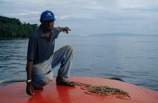 The 19 February 2004 eruption of Epi B, one of several cones of the submarine East Epi volcano, is seen here from the fishing boat Azur. Seen here from the Azur as a white area beyond the man's hand, the eruption breached the surface, ejecting water and steam. Eyewitnesses reported an eruption between 16 and 24 February, and the activity was confirmed by the infrasound recordings.
Copyrighted photo by crew of Azur, 2004 (courtesy of IRD, Noumea, New Caledonia).
 The steep-walled craters of the Marum cone complex at the summit of Ambrym volcano, seen from the east. Ambrym contains a 12-km-wide caldera and is one of the most active volcanoes of the New Hebrides arc. A thick pyroclastic sequence, initially dacitic, then basaltic, overlies lava flows of a pre-caldera shield volcano. Post-caldera eruptions, primarily from Marum and Benbow cones, have partially filled the caldera floor and produced lava flows that ponded on the caldera floor or overflowed through gaps in the caldera rim.
Photo by Karoly Nemeth, 2005 (Massey University).
 Charred vegetation marks the path of a pyroclastic flow on the SW flank of Lopevi on 19 February 2000. This view, taken 4 days later, shows part of the new 300-m-wide delta where the pyroclastic flow reached the sea. This was part of an ongoing eruption that began in July 1998. Intermittent explosive eruptions took place from the main 1963 crater (just NW of the central crater) and a small lava flow traveled 100 m within the crater.
 Photo by John Seach, 2000.
 An explosive eruption from Lake Voui at Ambae on 4 December 2005 seen looking approximately E from the crater rim. A dark cock’s-tail plume and a lighter gas-and-ash plume can be seen rising above the vent within the late. Three small islands that formed prior to this eruption can also be distinguished.
Photo by Philipson Bani, 2005 (Institut Recherche Développement, IRD).
 Vanua Lava Island of Vanuatu is shown in this February 2018 Planet Labs satellite image monthly mosaic (N is at the top; this image is approximately 40 km across). The majority of cones, craters, and features are in the northern part of the island, and comprise the Surematai volcano. The Pleistocene Ngere Kwon volcano formed the southernmost peninsula.
Satellite image courtesy of Planet Labs Inc., 2018 (https://www.planet.com/).
 The three small islands of Nguna, Pele, and Emau at the upper left, are located N of the large island of Efete (also known as Vate). Nguna and Pele appear to be a single island in this NASA Space Shuttle image (N is to the upper left), and Emau is the small circular island at the at the top center. These islands are thought to lie along or near the southern rim of a largely-submarine caldera of uncertain dimensions that extends to the N and may have formed about 2,000 years ago.
NASA Space Shuttle image STS068-206-50, 1994 (http://eol.jsc.nasa.gov/).
 A series of basaltic tuff rings and a scoria cone occupy the western tip of Ambrym, at the subaerial end of a fissure system that cuts across the length of the island. The largest tuff ring is about 1 km in diameter. The tuff rings were produced by phreatic eruptions when magma interacted with the water table or near-surface, water-saturated sediments along the coast. At higher elevations along the rift zone, scoria cones predominate.
Photo by Hunting Surveys, London (published in Green and Short, 1971).
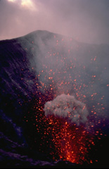
 Yasur, the best-known and most frequently visited of the Vanuatu volcanoes, has been in more-or-less continuous strombolian activity since Captain Cook observed ash eruptions in 1774. This style of activity may have continued for the past 800 years. Yasur is seen here from the west across windswept Lake Siwi. Frequent ash ejection has kept the 361-m-high pyroclastic cone mostly unvegetated.
Copyrighted photo by André Demaison, 1982 (courtesy of Katia and Maurice Krafft).
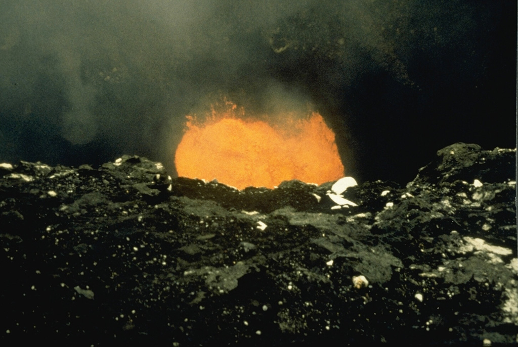
 On 27 May 1988 this lava lake was observed in Mbwelesu's crater, which along with Marum, was emitting ash plumes. Airline pilots had reported ash plumes below 12 km altitude from Benbow on 13 February. Vanuatu geologists reported increased activity from Benbow during 12-14 February, after which the volcano returned to normal. On 9-10 August lava flows were emitted from a new cone along the S flank, Niri Taten, and traveled towards the southern caldera wall. This eruption ended on 23 August.
Photo by Alain Melchior, 1988.
 The 4-5-km-diameter Mere Lava volcano is shown in this 14 March 2021 Planet Scope satellite image (N is at the top). It has a distinct summit crater that has a scoria cone with its own summit crater inside. Erosion has formed radial valleys down the flanks.
Satellite image courtesy of Planet Labs Inc., 2021 (https://www.planet.com/).
 Explosive activity that ejected ash and blocks from Niri Mbwelesu crater was observed on 16 September 1990. The Niri Mbwelesu crater formed adjacent to Mbwelesu crater in 1989 when Mbwelesu was also active but no longer contained a lava lake. During 1990 activity was concentrated in Mbwelesu, Niri Mbwelesu and Niri Mbwelesu Taten craters. Activity remained more or less constant into 1991.
Photo by Michel Lardy, 1990 (ORSTROM, Vanuata).
 Discolored water rises from the submarine Epi B vent in December 1958. This vent is one of the several East Epi cones located offshore of Epi Island in Vanuatu. Ephemeral islands were formed during eruptions in 1920 and 1953.
Copyrighted photo by Roland Priam, 1958 (courtesy of IRD, New Caledonia).
 A telephoto view looking approximately E from the crater rim on 4 December 2005 shows a Surtseyan eruption from Lake Voui, on Ambae volcano. This explosive eruption began in Lake Voui on 27 November and resulted in the formation of a new cone in the lake.
Photo by Philipson Bani, 2005 (Institut Recherche Développement, IRD).
 Clouds drape oval-shaped, 17-km-wide Aneityum Island in this NASA International Space Station image with north to the top. Aneityum, also known as Anatom, consists of two coalescing, dominantly basaltic Pleistocene volcanoes. Both the NW side of Inrerow Atamwan volcano (left) and the SE side of Nanawarez volcano (right) are truncated by large erosional cirques. Volcanic activity ceased during the late-Pleistocene to Holocene. Fringing reefs are visible on the northern side of the island.
NASA International Space Station image ISS006-E-5732, 2002 (http://eol.jsc.nasa.gov/).
 The elongated island of Motlav, also referred to as Mota Lava, lies in the northern Banks Islands of Vanuatu. The 12-km-long island is comprised of at least five Pleistocene basaltic stratovolcanoes capped by two well-preserved late-Pleistocene to Holocene pyroclastic cones, Tuntag and Vetnam. The low peak with a shadow above it at the lower left (SW) part of the island is Tuntog, a largely pyroclastic composite cone with a 500-m-wide summit crater. Vetnam pyroclastic cone lies in the center of the island.
NASA International Space Station image ISS006-E-26739, 2003 (http://eol.jsc.nasa.gov/).
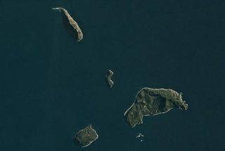 The NE Shepherd Islands group is south of Tongoa Island in Vanuatu and is shown in this 10 August 2020 PlanetScope satellite image (N is at the top). The islands are the northernmost, 2.8-km-long Ewose, Falea in the center, Tongariki to the SE, and Buninga to the SW. The islands contain outcrops of lava flows, pyroclastic deposits, and dikes.
Satellite image courtesy of Planet Labs Inc., 2020 (https://www.planet.com/).
 Craters and cones of Suretamatai in Vanua Lava Island, Vanuatu, are visible across this February 2018 Planet Labs satellite image monthly mosaic (N is at the top; this image is approximately 10 km across). The field covers much of the island, with a NNE-SSW trend of cones (shown here), with the largest edifice towards the northern end having formed multiple craters along a NW-SE trend. Geothermal activity continues.
Satellite image courtesy of Planet Labs Inc., 2019 (https://www.planet.com/).
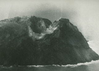
 The summit crater complex of Mt. Garat with Lake Letas in the background, seen here from the S. A plume rises from the SE crater. Strong continuous degassing began following an increase in fumarolic activity in April 1991 and was continuing at the time of this July 1991 photo. Mt. Garat is located within the 6 x 9 km wide caldera that is partially filled by Lake Letas. The northern caldera rim is in the background.
Photo by Claude Robin, 1991 (ORSTROM, Vanuatu).
 A plume rises from a crater lake inside the new island formed during an eruption at Ambae beginning on 27 November 2005. This 9 January 2006 view looks toward the N. The new island was more than 500 m wide at this time and contained an internal lake.
Photo by Job Eassau, 2006 (courtesy of Esline Garaebiti, Dept of Geology, Mines, and Water Resources, Port Vila).
 The Lopevi SE-flank eruptive fissure in May 1995 is visible in this photo. The small 7-km-wide island is frequently active with both summit and flank vents, primarily on the NW and SE sides, producing moderate explosive eruptions and lava flows that reach the coast. Historical eruptions date back to the mid-19th century. Paama Island (left) and Ambrym Island (right) are in the background to the north.
 Photo by P. Evin, 1995 (Institut de Recherche pour le Développement, Vanuatu; Bull. Global Volcanism Network, 1999).
 Traitor's Head Peninsula of Erromango Island is shown in this July 2019 Planet Labs satellite image monthly mosaic (N is at the top; this image is approximately 10 km across). Three eroded volcanic edifices are visible, Nagat to the NE, Rantop in the center, and Oulenou with the summit crater to the W.
Satellite image courtesy of Planet Labs Inc., 2019 (https://www.planet.com/).
 On 27 November 1976 a plume, water discoloration, and sulfur odor were reported from Matthew Island. It was later noted that no noticeable eruptive event or change in island morphology had occurred since 1958. This February 1977 photo shows the steaming crater of Matthew Island volcano.
Photo by Royal New Zealand Air Force, 1977.
 Matthew Island is composed of two cones separated by a narrow isthmus. Only the triangular eastern portion of the small, 0.6 x 1.2 km wide island existed prior to the 1940s, after which eruptions began to build the larger western segment (part of which is seen in the photo). The western cone consists primarily of lava flows and contains a crater that is breached to the NW.
Photo by Royal New Zealand Air Force, 1977.
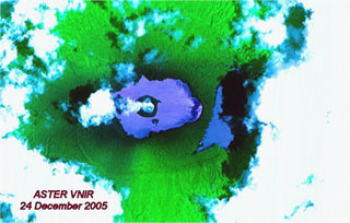 An ASTER false-color satellite image of Ambae taken on 24 December 2005 shows a plume from Lake Voui above a new island that formed during an eruption that began on 27 November. The eruption built the new island with its own crater lake near the center of Lake Voui; this island has a mean diameter at this time of 525 m. Lake Manaro Lakua at the right sits within the eastern end of the caldera and is partly obscured by cloud and shadow.
NASA ASTER image, 2005 (courtesy of Alain Bernard, Université Libre de Bruxelles).
This is a compilation of Vanuatu volcano information sources, such as official monitoring or other government agencies.
| Volcano Observatories |
|---|
| Vanuatu Meteorology and Geo-Hazards Department (VMGD) |
| - VMGD Activity Bulletins |
| - VMGD Alert Levels |
| - VMGD Facebook |
| Civil Protection Agencies |
|---|
| National Disaster Management Office (NDMO) |
| - NDMO - Facebook |
| Volcanic Ash Advisory Center |
|---|
| Wellington Volcanic Ash Advisory Center (VAAC) |
| - Wellington VAAC Notices |