The VSI reported two explosions at Peuet Sague on 25 December, and another the next day. The explosions deposited ash over a wide area including villages 20 km from the summit. As of about 8 January lava flows were visible at the volcano from Trans village, 7 km away. The volcano is at Alert Level 2 (on a scale of 1-4).
Source: Pusat Vulkanologi dan Mitigasi Bencana Geologi (PVMBG, also known as CVGHM)
1999 activity continues through 14 June; explosions in late December 2000
Peuet Sague's 1999 activity (BGVN 24:05) was reported to have continued, although at a decreased level, through 14 June 1999. A malfunctioning seismograph prevented instrumental monitoring in late May, but thin white gas-and-steam plumes that rose ~15 m were visible. During the first week in June plumes continued to rise to heights of 20 m. Rumbling was heard on 18 occasions, and plumes continued to rise through 14 June.
The VSI did not release further reports until renewed activity began at 0800 on 25 December 2000 with the first of three explosions. A second explosion occurred at 1310, and a third one followed at 1130 on 26 December. The explosions generated ash that spread over a relatively large area. Ashfall occurred on Geumpang, Lutung, Mane, and Bangke villages up to 20 km away. An observer from the village of Trans reported having seen glowing lava flows at night. Reported emissions ceased for the remainder of 2000, and the hazard status stayed at 2 (on a scale of 1-4).
Information Contacts: Dali Ahmad, Volcanological Survey of Indonesia (VSI), Jalan Diponegoro No. 57, Bandung 40122, Indonesia (URL: http://www.vsi.esdm.go.id/).
2001: January
The VSI reported two explosions at Peuet Sague on 25 December, and another the next day. The explosions deposited ash over a wide area including villages 20 km from the summit. As of about 8 January lava flows were visible at the volcano from Trans village, 7 km away. The volcano is at Alert Level 2 (on a scale of 1-4).
Source: Pusat Vulkanologi dan Mitigasi Bencana Geologi (PVMBG, also known as CVGHM)
Reports are organized chronologically and indexed below by Month/Year (Publication Volume:Number), and include a one-line summary. Click on the index link or scroll down to read the reports.
Pilots spot ash erupting from remote volcano in N Sumatra beginning in late April
An eruption of Mount Peuet Sague, in a remote part of northern Sumatra, was first seen the morning of 26 April by pilots. Indonesia's Antara news agency reported on 27 April that a pilot of the national airline, Garuda, saw a volcano erupting in the province of Aceh, in the Pidie area. The report said the pilot saw ash to an altitude of ~3 km as he flew over at ~7 km altitude. The report also quoted the local Air Force chief as saying a fighter pilot spotted fire and thick smoke issuing from the mountain. It was the second recent eruption there: the first, on 19 April, was obscured by thick smoke from forest fires.
Officials at the Ministry of Mines and Energy, which has responsibility for monitoring volcanic activity in Aceh Province, reported a phreatic eruption. The active crater is near Mount Tutung, 2 km W of the peak of Peuet Sague. The nearest village sits 8 km W of the eruption center. No one was harmed and it appears few noticed, as there were no accounts from local residents of sounds, tremors, or ashfall. There were some indications of material ejected from the crater. A 15 May statement said white smoke was weakly issuing from the volcano, but that all other activity had ceased.
Peuet Sague is remote and scientific information is accordingly difficult to collect. VSI observers who went to the area shortly after the latest eruption were delayed because they had to walk nearly four days to reach the volcano. The Mount Peuet Sague Volcano Observatory was initiated at the end of 1997 but had been equipped with neither monitoring devices nor observers at the time of this activity. VSI planned to install one radio telemetric seismograph and to employ one observer by late May 1998.
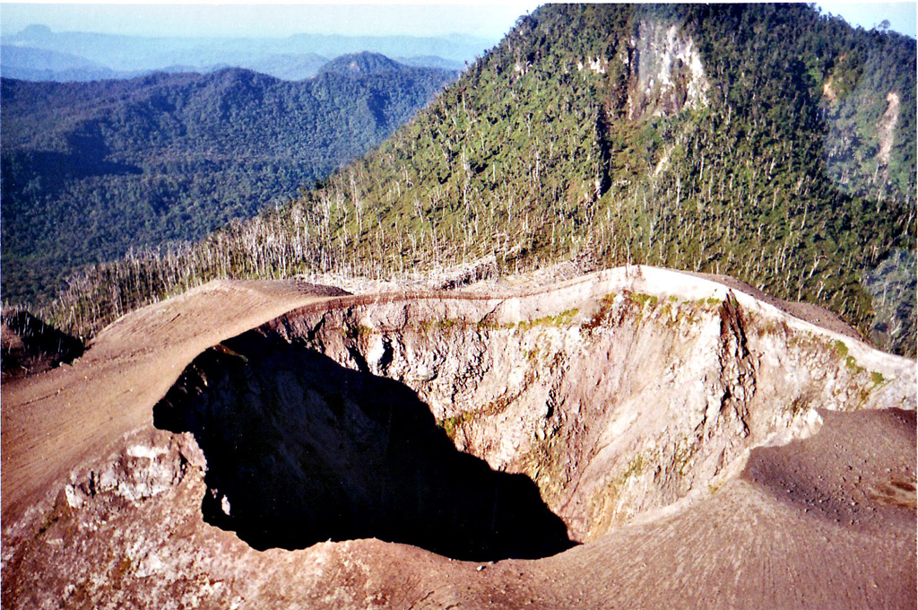
Background. The name Peuet Sague, which has numerous spelling variants (e.g. Peut Sagoe, Peuet Sagu, Puet Sagu, Peuet Sagoee), means "square." Accordingly, Peuet Sague, a stratovolcano, contains four summit peaks. It is located in Sigli Regency, Aceh Province near Seulawah Agam and Burni Telong volcanoes. The crater believed to be active resides SE of one of the peaks of the lava dome (Mount Tutung). This narrow crater has a diameter of about 70 m and a depth of 80 m.
According to Igan Sutawidjaja, a May 1920 expedition was stopped by heavy ashfall and a 1952 expedition spent 20 days without reaching the volcano. A 1975 team reached the peak after nine days but found no eruptive activity. They documented a lake (500 x 800 m) at the foot of Mount Tutung containing water at a temperature of 19°C. Within Tutung's crater they found a small (40 x 75 m) blue lake with a temperature of 21°C. This intracrater lake was surrounded by four solfataras (with temperatures of 59-78°C).
The last major eruption occurred in 1918-21 when ash was emitted, a lava dome was formed, and pyroclastic flows spilled into surrounding uninhabited forests. Scientists inspecting the summit area in 1984 found burned trees surrounding the main crater, likely due to a 1979 eruption. Local eye-witnesses and pilots reported ash columns above the summit in 1979, 1986, and 1991. An expedition in 1984 found burned trees surrounding the crater, attributed to the 1979 eruption. Uncertain activity was reported in 1949.
Information Contacts: Mahbub Iskandar, Ministry of Mines and Energy, Banda Aceh, Sumatra, Indonesia; Igan S. Sutawidjaja, Volcanological Survey of Indonesia (VSI), Jalan Diponegoro No.57, Bandung 40122, Indonesia (URL: http://www.vsi.esdm.go.id/); Reuters News Agency; Associated Press.
March-May activity initially increased and later slackened; minor ash emissions
During 9 March-24 May activity initially increased but later diminished. Volcanic activity increased during 9-15 March and people in the local settlement heard booming noises about 20 times/day. From 16 to 22 March, volcanic activity continued at the same scale, but the booming noises weakened. The seismic record also illustrated decreased intensity. Activity continued through the week of 23-29 March without diminishing, but the booming noises ceased. Volcanic and tectonic events increased, with volcanic type-B earthquakes rising from 6 to 15 and tectonic events increasing from 1 to 18. From 27 April to 3 May volcanic earthquakes increased and an eruption emitted white-gray ash to 200 m.
Activity began tapering during 4-10 May. A white plume was observed at heights of 10-20 m. Volcanic shocks decreased. Activity continued to decline during 11-17 May, with a plume ranging from 10 to 200 m heights. Volcanic activity was not recorded during 18-24 May, but observers reported 14 "thin white ash plumes" rising 10-50 m.
The Peuet Sague stratovolcano contains four summit peaks. The crater believed to be active resides SE of one of the peaks of the lava dome (Mount Tutung). This narrow crater has a diameter of about 70 m and a depth of 80 m. The last major eruption occurred in 1918-21 when ash was emitted, a lava dome was formed, and pyroclastic flows spilled into surrounding uninhabited forests. A 1975 team that reached the peak found no eruptive activity, but documented a lake (500 x 800 m) at the foot of Mount Tutung. Within Tutung's crater they found a small (40 x 75 m) blue lake surrounded by four solfataras. Scientists inspecting the summit area in 1984 found burned trees surrounding the main crater, likely due to a 1979 eruption. Local eyewitnesses and pilots reported ash columns above the summit in 1979, 1986, and 1991.
Information Contacts: Volcanological Survey of Indonesia (VSI), Jalan Diponegoro No. 57, Bandung 40122, Indonesia (URL: http://www.vsi.esdm.go.id/).
1999 activity continues through 14 June; explosions in late December 2000
Peuet Sague's 1999 activity (BGVN 24:05) was reported to have continued, although at a decreased level, through 14 June 1999. A malfunctioning seismograph prevented instrumental monitoring in late May, but thin white gas-and-steam plumes that rose ~15 m were visible. During the first week in June plumes continued to rise to heights of 20 m. Rumbling was heard on 18 occasions, and plumes continued to rise through 14 June.
The VSI did not release further reports until renewed activity began at 0800 on 25 December 2000 with the first of three explosions. A second explosion occurred at 1310, and a third one followed at 1130 on 26 December. The explosions generated ash that spread over a relatively large area. Ashfall occurred on Geumpang, Lutung, Mane, and Bangke villages up to 20 km away. An observer from the village of Trans reported having seen glowing lava flows at night. Reported emissions ceased for the remainder of 2000, and the hazard status stayed at 2 (on a scale of 1-4).
Information Contacts: Dali Ahmad, Volcanological Survey of Indonesia (VSI), Jalan Diponegoro No. 57, Bandung 40122, Indonesia (URL: http://www.vsi.esdm.go.id/).
|
|
||||||||||||||||||||||||||
There is data available for 7 confirmed Holocene eruptive periods.
2000 Dec 25 - 2000 Dec 26 (on or after) Confirmed Eruption (Explosive / Effusive) VEI: 2
| Episode 1 | Eruption (Explosive / Effusive) | ||||||||||||||||||||||||||||||
|---|---|---|---|---|---|---|---|---|---|---|---|---|---|---|---|---|---|---|---|---|---|---|---|---|---|---|---|---|---|---|
| 2000 Dec 25 - 2000 Dec 26 (on or after) | Evidence from Observations: Reported | |||||||||||||||||||||||||||||
|
List of 4 Events for Episode 1
|
||||||||||||||||||||||||||||||
1999 Mar 9 (?) - 1999 Apr 30 ± 3 days Confirmed Eruption (Explosive / Effusive) VEI: 1
| Episode 1 | Eruption (Explosive / Effusive) | |||||||||||||||||||||||||||||||||||
|---|---|---|---|---|---|---|---|---|---|---|---|---|---|---|---|---|---|---|---|---|---|---|---|---|---|---|---|---|---|---|---|---|---|---|---|
| 1999 Mar 9 (?) - 1999 Apr 30 ± 3 days | Evidence from Observations: Reported | ||||||||||||||||||||||||||||||||||
|
List of 5 Events for Episode 1
|
|||||||||||||||||||||||||||||||||||
1998 Apr 19 - 1998 Apr 26 (?) Confirmed Eruption (Explosive / Effusive) VEI: 1
| Episode 1 | Eruption (Explosive / Effusive) | |||||||||||||||||||||||||
|---|---|---|---|---|---|---|---|---|---|---|---|---|---|---|---|---|---|---|---|---|---|---|---|---|---|
| 1998 Apr 19 - 1998 Apr 26 (?) | Evidence from Observations: Reported | ||||||||||||||||||||||||
|
List of 3 Events for Episode 1
|
|||||||||||||||||||||||||
1991 Jul 2 ± 182 days Confirmed Eruption (Explosive / Effusive) VEI: 2
| Episode 1 | Eruption (Explosive / Effusive) | |||||||||||||||||||||||||
|---|---|---|---|---|---|---|---|---|---|---|---|---|---|---|---|---|---|---|---|---|---|---|---|---|---|
| 1991 Jul 2 ± 182 days - Unknown | Evidence from Observations: Reported | ||||||||||||||||||||||||
|
List of 3 Events for Episode 1
|
|||||||||||||||||||||||||
1986 Jul 2 ± 182 days Confirmed Eruption (Explosive / Effusive) VEI: 2
| Episode 1 | Eruption (Explosive / Effusive) | |||||||||||||||||||||||||
|---|---|---|---|---|---|---|---|---|---|---|---|---|---|---|---|---|---|---|---|---|---|---|---|---|---|
| 1986 Jul 2 ± 182 days - Unknown | Evidence from Observations: Reported | ||||||||||||||||||||||||
|
List of 3 Events for Episode 1
|
|||||||||||||||||||||||||
1979 Jul 2 ± 182 days Confirmed Eruption (Explosive / Effusive) VEI: 2
| Episode 1 | Eruption (Explosive / Effusive) | |||||||||||||||||||||||||
|---|---|---|---|---|---|---|---|---|---|---|---|---|---|---|---|---|---|---|---|---|---|---|---|---|---|
| 1979 Jul 2 ± 182 days - Unknown | Evidence from Observations: Reported | ||||||||||||||||||||||||
|
List of 3 Events for Episode 1
|
|||||||||||||||||||||||||
1918 - 1921 Confirmed Eruption (Explosive / Effusive) VEI: 2
| Episode 1 | Eruption (Explosive / Effusive) | ||||||||||||||||||||||||||||||
|---|---|---|---|---|---|---|---|---|---|---|---|---|---|---|---|---|---|---|---|---|---|---|---|---|---|---|---|---|---|---|
| 1918 - 1921 | Evidence from Observations: Reported | |||||||||||||||||||||||||||||
|
List of 4 Events for Episode 1
|
||||||||||||||||||||||||||||||
This compilation of synonyms and subsidiary features may not be comprehensive. Features are organized into four major categories: Cones, Craters, Domes, and Thermal Features. Synonyms of features appear indented below the primary name. In some cases additional feature type, elevation, or location details are provided.
Synonyms |
||||
| Puet Sagu | Peut Sagoe | Peuet Sagoee | ||||
Cones |
||||
| Feature Name | Feature Type | Elevation | Latitude | Longitude |
| Gunung Peutsagu | Cone | 2495 m | 4° 54' 22.00" N | 96° 18' 16.00" E |
Domes |
||||
| Feature Name | Feature Type | Elevation | Latitude | Longitude |
| Tutung, Gunung | Dome | 2545 m | 4° 53' 50.00" N | 96° 17' 6.00" E |
Other |
||||
| Feature Name | Feature Type | Elevation | Latitude | Longitude |
| Gunung Kemiki | Crater Rim | 2785 m | 4° 54' 54.00" N | 96° 19' 44.00" E |
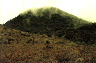 Thin clouds drape one the peaks of Peuet Sague volcano in NW Sumatra. The first recorded historical eruption took place during 1918-21, when explosive activity and pyroclastic flows accompanied lava dome growth.
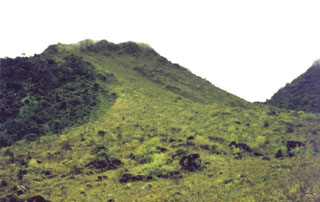 Vegetation drapes one of the peaks forming the Peuet Sague complex in NW Sumatra. This isolated volcano is a several-day journey on foot from the nearest village and is infrequently visited. The first recorded historical eruption took place during 1918-21, when explosive activity and pyroclastic flows accompanied lava dome growth.
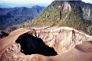 The summit crater of Peuet Sague is part of a large volcanic complex in NW Sumatra. The first recorded historical eruption took place during 1918-21, when explosive activity and pyroclastic flows accompanied summit lava-dome growth. The historically-active crater has typically produced small-to-moderate explosive eruptions.
There are no samples for Peuet Sague in the Smithsonian's NMNH Department of Mineral Sciences Rock and Ore collection.
| Copernicus Browser | The Copernicus Browser replaced the Sentinel Hub Playground browser in 2023, to provide access to Earth observation archives from the Copernicus Data Space Ecosystem, the main distribution platform for data from the EU Copernicus missions. |
| MIROVA | Middle InfraRed Observation of Volcanic Activity (MIROVA) is a near real time volcanic hot-spot detection system based on the analysis of MODIS (Moderate Resolution Imaging Spectroradiometer) data. In particular, MIROVA uses the Middle InfraRed Radiation (MIR), measured over target volcanoes, in order to detect, locate and measure the heat radiation sourced from volcanic activity. |
| MODVOLC Thermal Alerts | Using infrared satellite Moderate Resolution Imaging Spectroradiometer (MODIS) data, scientists at the Hawai'i Institute of Geophysics and Planetology, University of Hawai'i, developed an automated system called MODVOLC to map thermal hot-spots in near real time. For each MODIS image, the algorithm automatically scans each 1 km pixel within it to check for high-temperature hot-spots. When one is found the date, time, location, and intensity are recorded. MODIS looks at every square km of the Earth every 48 hours, once during the day and once during the night, and the presence of two MODIS sensors in space allows at least four hot-spot observations every two days. Each day updated global maps are compiled to display the locations of all hot spots detected in the previous 24 hours. There is a drop-down list with volcano names which allow users to 'zoom-in' and examine the distribution of hot-spots at a variety of spatial scales. |
|
WOVOdat
Single Volcano View Temporal Evolution of Unrest Side by Side Volcanoes |
WOVOdat is a database of volcanic unrest; instrumentally and visually recorded changes in seismicity, ground deformation, gas emission, and other parameters from their normal baselines. It is sponsored by the World Organization of Volcano Observatories (WOVO) and presently hosted at the Earth Observatory of Singapore.
GVMID Data on Volcano Monitoring Infrastructure The Global Volcano Monitoring Infrastructure Database GVMID, is aimed at documenting and improving capabilities of volcano monitoring from the ground and space. GVMID should provide a snapshot and baseline view of the techniques and instrumentation that are in place at various volcanoes, which can be use by volcano observatories as reference to setup new monitoring system or improving networks at a specific volcano. These data will allow identification of what monitoring gaps exist, which can be then targeted by remote sensing infrastructure and future instrument deployments. |
| Volcanic Hazard Maps | The IAVCEI Commission on Volcanic Hazards and Risk has a Volcanic Hazard Maps database designed to serve as a resource for hazard mappers (or other interested parties) to explore how common issues in hazard map development have been addressed at different volcanoes, in different countries, for different hazards, and for different intended audiences. In addition to the comprehensive, searchable Volcanic Hazard Maps Database, this website contains information about diversity of volcanic hazard maps, illustrated using examples from the database. This site is for educational purposes related to volcanic hazard maps. Hazard maps found on this website should not be used for emergency purposes. For the most recent, official hazard map for a particular volcano, please seek out the proper institutional authorities on the matter. |
| IRIS seismic stations/networks | Incorporated Research Institutions for Seismology (IRIS) Data Services map showing the location of seismic stations from all available networks (permanent or temporary) within a radius of 0.18° (about 20 km at mid-latitudes) from the given location of Peuet Sague. Users can customize a variety of filters and options in the left panel. Note that if there are no stations are known the map will default to show the entire world with a "No data matched request" error notice. |
| UNAVCO GPS/GNSS stations | Geodetic Data Services map from UNAVCO showing the location of GPS/GNSS stations from all available networks (permanent or temporary) within a radius of 20 km from the given location of Peuet Sague. Users can customize the data search based on station or network names, location, and time window. Requires Adobe Flash Player. |
| DECADE Data | The DECADE portal, still in the developmental stage, serves as an example of the proposed interoperability between The Smithsonian Institution's Global Volcanism Program, the Mapping Gas Emissions (MaGa) Database, and the EarthChem Geochemical Portal. The Deep Earth Carbon Degassing (DECADE) initiative seeks to use new and established technologies to determine accurate global fluxes of volcanic CO2 to the atmosphere, but installing CO2 monitoring networks on 20 of the world's 150 most actively degassing volcanoes. The group uses related laboratory-based studies (direct gas sampling and analysis, melt inclusions) to provide new data for direct degassing of deep earth carbon to the atmosphere. |
| Large Eruptions of Peuet Sague | Information about large Quaternary eruptions (VEI >= 4) is cataloged in the Large Magnitude Explosive Volcanic Eruptions (LaMEVE) database of the Volcano Global Risk Identification and Analysis Project (VOGRIPA). |
| EarthChem | EarthChem develops and maintains databases, software, and services that support the preservation, discovery, access and analysis of geochemical data, and facilitate their integration with the broad array of other available earth science parameters. EarthChem is operated by a joint team of disciplinary scientists, data scientists, data managers and information technology developers who are part of the NSF-funded data facility Integrated Earth Data Applications (IEDA). IEDA is a collaborative effort of EarthChem and the Marine Geoscience Data System (MGDS). |

