The Pusat Vulkanologi dan Mitigasi Bencana Geologi (PVMBG) reported a decrease in seismicity at Iya during 5 November 2024-7 January 2025. Deep earthquakes indicating a magma presence continued to be recorded, and continuous tremor persisted but with a decreasing amplitude. In general, white emissions rose as high as 500 m above the summit and drifted in multiple directions, though emissions that rose 10-200 m above the crater rim during 1-7 January were characterized as white-and-gray. At 1800 on 8 January the Alert Level was lowered to 2 (on a scale of 1-4) and the public was warned to stay 2 km away from the active crater.
Source: Pusat Vulkanologi dan Mitigasi Bencana Geologi (PVMBG, also known as CVGHM)
Summary of January-February eruption
Card 0491-0492 (10 April 1969) Summary of January-February eruption
Eruption of Mount Ija 27 January 1969 from 0400 to 1100 ejecting volcanic lapilli sand ash. Smoke caused by the eruption 5 km high having black, white, yellow, and blue colors. Ejected fire caused burning from top to slope for three hours. Thundering sound started from 0400 until 1100 sharp, stopping abruptly like the engine of an automobile being stopped. Since 1100 that day until 29 February it continued to eject smoke as big and as high during the time of eruption without thundering but at times producing explosive sounds. Gas pressure getting weak.
30 January till 4 February it continued to eject thick smoke as high as 500 m but in general reaching a maximum of 100 m while smoke thickness getting small. Lava flow and volcanic hot cloud did not appear and have no trace. Volcanic earthquake and volcanic tremor continuously felt for seven hours during the eruption. 1-6 February volcanic earthquakes maximum eight times minimum three times a day, one day none. Collapses maximum 43 times minimum four times a day. 7-17 February volcanic earthquake only once a day, three days none. Furthermore, tectonic earthquake occurred once. Collapses maximum seven times minimum two times a day. 18-25 February volcanic earthquake maximum four times twice a day, five days none, with additional tectonic earthquake thrice. Collapses maximum seven times minimum once a day, three days none.
The temperature of solfatara at the top on 10 February minimum 100°C. On 17 February maximum 315°C minimum 98°C. On 24 February maximum 300°C minimum 100°C. The temperature of solfatara at the top in normal condition maximum only 98°C. On 10 and 17 February solfatara in Region B produced sizzling sound, and on 24 February Region A inclusive all produced sizzling sound. The temperature of the atmosphere at the top on 10 February was 34°C, on 17 February it dropped to 33°C, and on 24 February it dropped to 32°C.
Information Contacts: Indonesian Volcanological Service, Ende, Flores, Indonesia; American Embassy, Djakarta, Indonesia.
2025: January
2024: January
| October
| November
2016: September
| November
The Pusat Vulkanologi dan Mitigasi Bencana Geologi (PVMBG) reported a decrease in seismicity at Iya during 5 November 2024-7 January 2025. Deep earthquakes indicating a magma presence continued to be recorded, and continuous tremor persisted but with a decreasing amplitude. In general, white emissions rose as high as 500 m above the summit and drifted in multiple directions, though emissions that rose 10-200 m above the crater rim during 1-7 January were characterized as white-and-gray. At 1800 on 8 January the Alert Level was lowered to 2 (on a scale of 1-4) and the public was warned to stay 2 km away from the active crater.
Source: Pusat Vulkanologi dan Mitigasi Bencana Geologi (PVMBG, also known as CVGHM)
The Pusat Vulkanologi dan Mitigasi Bencana Geologi (PVMBG) reported that white-and-gray emissions at Iya rose as high as 300 m above the crater rim and drifted NE, N, W, and SW during 13-14 November. White plumes rose 100-300 m above the crater rim and drifted in multiple directions during the rest of the week. The Alert Level remained at 3 (on a scale of 1-4) and the public was warned to stay 3 km away from the active crater area in all directions and 5 km away to the south.
Source: Pusat Vulkanologi dan Mitigasi Bencana Geologi (PVMBG, also known as CVGHM)
The Pusat Vulkanologi dan Mitigasi Bencana Geologi (PVMBG) reported that daily white emissions at Iya rose as high as 300 m above the crater rim and drifted in several directions during 6-12 November. The Alert Level remained at 3 (on a scale of 1-4) and the public was warned to stay 3 km away from the active crater area in all directions and 5 km away to the south.
Source: Pusat Vulkanologi dan Mitigasi Bencana Geologi (PVMBG, also known as CVGHM)
The Pusat Vulkanologi dan Mitigasi Bencana Geologi (PVMBG) reported that daily white emissions at Iya rose as high as 350 m above the cater rim and drifted in several directions during 30 October-5 November. At 1800 on 5 November the Alert Level increased from 2 to 3 (on a scale of 1-4) due to increased seismic activity, and the public was warned to stay 3 km away from the active crater area in all directions and 5 km away to the south.
Source: Pusat Vulkanologi dan Mitigasi Bencana Geologi (PVMBG, also known as CVGHM)
The Pusat Vulkanologi dan Mitigasi Bencana Geologi (PVMBG) reported that daily white emissions at Iya rose as high as 308 m above the cater rim and drifted in multiple directions during 23-29 October. The Alert Level remained at 2 (on a scale of 1-4) and the public was warned to stay 2 km away from the active crater area.
Source: Pusat Vulkanologi dan Mitigasi Bencana Geologi (PVMBG, also known as CVGHM)
The Pusat Vulkanologi dan Mitigasi Bencana Geologi (PVMBG) reported that there was an increase in activity and potential hazards at Iya, based on visual and instrumental monitoring data during 16-22 October. The Alert Level was raised to 2 (on a scale of 1-4) at 0800 on 17 October, and the public was warned to stay 2 km away from the active crater area.
Source: Pusat Vulkanologi dan Mitigasi Bencana Geologi (PVMBG, also known as CVGHM)
PVMBG reported that during 1-31 December diffuse white plumes rose as high as 80 m above Iya’s summit. During most of that period seismicity was at normal levels and characterized by both deep and shallow volcanic earthquakes. A total of 55 deep volcanic earthquakes were recorded during the month with 12 of them recorded during 30-31 December, signifying a significant increase during that period. The Alert Level was remained at 1 (on a scale of 1-4), and the public was warned to limit activity near the active crater area.
Source: Pusat Vulkanologi dan Mitigasi Bencana Geologi (PVMBG, also known as CVGHM)
PVMBG reported that after an increase on 29 September seismicity at Iya decreased significantly, with the number of deep volcanic earthquakes slowing from a rate of five per day or less, to none on 22 October. On 31 October the Alert Level was lowered to 1 (on a scale of 1-4).
Source: Pusat Vulkanologi dan Mitigasi Bencana Geologi (PVMBG, also known as CVGHM)
PVMBG reported that during 1 July-29 September variable-density white plumes rose as high as 150 m above Iya. During most of that period seismicity was at normal levels characterized by deep and shallow volcanic earthquakes each detected at a rate of less than 10 events per day. Between 1550 and 1800 on 29 September, however, the seismic network detected 17 volcanic earthquakes. Since the number of volcanic earthquakes was significant and above normal levels, the Alert Level was raised to 2 (on a scale of 1-4), and the public was warned not to approach the crater within a 2-km radius.
Source: Pusat Vulkanologi dan Mitigasi Bencana Geologi (PVMBG, also known as CVGHM)
Reports are organized chronologically and indexed below by Month/Year (Publication Volume:Number), and include a one-line summary. Click on the index link or scroll down to read the reports.
Eruption begins on 27 January with thick dark clouds
Card 0408 (17 February 1969) Heavy dark clouds seen from 27 January eruption
The recent eruptive activity began on 27 January 1969 in the early morning between 0400 and 0700. During a flight between Kupang (Timor) and Den Pasar (Bali) on that day, the area of the disaster was covered by heavy dark clouds. Refugees of Endeh toen, the capital of Flores Island, are reported to have fled to Maumere, a village on the north coast of the island.
Card 0418 (20 February 1969) Residents evacuated following lava and smoke eruption
Inhabitants of the area surrounding the Ija Volcano fled from the dangerous grounds of this volcano, which spit hot lava and thick smoke. The volcano with its highest elevation of 650 m is considered a very dangerous volcano due to the two craters it has - one above and one below sea level. Ija volcano at Tandjing Endeh in Flores, erupted on 27 January. The crew of a G.I.A. airplane flying over Flores on route from Kupang to Den Pasar on the morning of 28 January witnessed a thick smoke above the disaster area. Surrounding residents and inhabitants have been evacuated to Maumhe? The Geological Service has sent an investigation team.
Information Contacts:
Card 0408 (17 February 1969) G.A. De Nève, Universitas Padjadjaran, Bandung.
Card 0418 (20 February 1969) Djajadi Hadikusumo, Geological Survey of Indonesia.
Summary of January-February eruption
Card 0491-0492 (10 April 1969) Summary of January-February eruption
Eruption of Mount Ija 27 January 1969 from 0400 to 1100 ejecting volcanic lapilli sand ash. Smoke caused by the eruption 5 km high having black, white, yellow, and blue colors. Ejected fire caused burning from top to slope for three hours. Thundering sound started from 0400 until 1100 sharp, stopping abruptly like the engine of an automobile being stopped. Since 1100 that day until 29 February it continued to eject smoke as big and as high during the time of eruption without thundering but at times producing explosive sounds. Gas pressure getting weak.
30 January till 4 February it continued to eject thick smoke as high as 500 m but in general reaching a maximum of 100 m while smoke thickness getting small. Lava flow and volcanic hot cloud did not appear and have no trace. Volcanic earthquake and volcanic tremor continuously felt for seven hours during the eruption. 1-6 February volcanic earthquakes maximum eight times minimum three times a day, one day none. Collapses maximum 43 times minimum four times a day. 7-17 February volcanic earthquake only once a day, three days none. Furthermore, tectonic earthquake occurred once. Collapses maximum seven times minimum two times a day. 18-25 February volcanic earthquake maximum four times twice a day, five days none, with additional tectonic earthquake thrice. Collapses maximum seven times minimum once a day, three days none.
The temperature of solfatara at the top on 10 February minimum 100°C. On 17 February maximum 315°C minimum 98°C. On 24 February maximum 300°C minimum 100°C. The temperature of solfatara at the top in normal condition maximum only 98°C. On 10 and 17 February solfatara in Region B produced sizzling sound, and on 24 February Region A inclusive all produced sizzling sound. The temperature of the atmosphere at the top on 10 February was 34°C, on 17 February it dropped to 33°C, and on 24 February it dropped to 32°C.
Information Contacts: Indonesian Volcanological Service, Ende, Flores, Indonesia; American Embassy, Djakarta, Indonesia.
|
|
||||||||||||||||||||||||||
There is data available for 8 confirmed eruptive periods.
[ 1971 Jun 16 ± 15 days - 1971 Jun 16 ± 15 days ] Uncertain Eruption
| Episode 1 | Eruption (Explosive / Effusive) | ||||||||||||||||||||||||
|---|---|---|---|---|---|---|---|---|---|---|---|---|---|---|---|---|---|---|---|---|---|---|---|---|
| 1971 Jun 16 ± 15 days - 1971 Jun 16 ± 15 days | Evidence from Unknown | |||||||||||||||||||||||
|
List of 3 Events for Episode 1
|
||||||||||||||||||||||||
1969 Jan 27 - 1969 Jan 30 Confirmed Eruption (Explosive / Effusive) VEI: 3
| Episode 1 | Eruption (Explosive / Effusive) | Crater II (upper SW flank) | ||||||||||||||||||||||||||||||||||||||||||||||||||||||||||||||||||||||||||||||
|---|---|---|---|---|---|---|---|---|---|---|---|---|---|---|---|---|---|---|---|---|---|---|---|---|---|---|---|---|---|---|---|---|---|---|---|---|---|---|---|---|---|---|---|---|---|---|---|---|---|---|---|---|---|---|---|---|---|---|---|---|---|---|---|---|---|---|---|---|---|---|---|---|---|---|---|---|---|---|---|
| 1969 Jan 27 - 1969 Jan 30 | Evidence from Observations: Reported | ||||||||||||||||||||||||||||||||||||||||||||||||||||||||||||||||||||||||||||||
|
List of 14 Events for Episode 1 at Crater II (upper SW flank)
|
|||||||||||||||||||||||||||||||||||||||||||||||||||||||||||||||||||||||||||||||
1953 Sep 4 - 1953 Sep 5 Confirmed Eruption (Explosive / Effusive) VEI: 2 (?)
| Episode 1 | Eruption (Explosive / Effusive) | ||||||||||||||||||||||||
|---|---|---|---|---|---|---|---|---|---|---|---|---|---|---|---|---|---|---|---|---|---|---|---|---|
| 1953 Sep 4 - 1953 Sep 5 | Evidence from Observations: Reported | |||||||||||||||||||||||
|
List of 3 Events for Episode 1
|
||||||||||||||||||||||||
[ 1888 Dec ] Uncertain Eruption
| Episode 1 | Eruption (Explosive / Effusive) | ||||||||||||||
|---|---|---|---|---|---|---|---|---|---|---|---|---|---|---|
| 1888 Dec - Unknown | Evidence from Unknown | |||||||||||||
|
List of 1 Events for Episode 1
|
||||||||||||||
1882 Confirmed Eruption (Explosive / Effusive) VEI: 2
| Episode 1 | Eruption (Explosive / Effusive) | |||||||||||||||||||
|---|---|---|---|---|---|---|---|---|---|---|---|---|---|---|---|---|---|---|---|
| 1882 - Unknown | Evidence from Observations: Reported | ||||||||||||||||||
|
List of 2 Events for Episode 1
|
|||||||||||||||||||
1871 Sep 1 Confirmed Eruption (Explosive / Effusive) VEI: 2
| Episode 1 | Eruption (Explosive / Effusive) | |||||||||||||||||||
|---|---|---|---|---|---|---|---|---|---|---|---|---|---|---|---|---|---|---|---|
| 1871 Sep 1 - Unknown | Evidence from Observations: Reported | ||||||||||||||||||
|
List of 2 Events for Episode 1
|
|||||||||||||||||||
1868 May 4 Confirmed Eruption (Explosive / Effusive) VEI: 2
| Episode 1 | Eruption (Explosive / Effusive) | ||||||||||||||||||||||||
|---|---|---|---|---|---|---|---|---|---|---|---|---|---|---|---|---|---|---|---|---|---|---|---|---|
| 1868 May 4 - Unknown | Evidence from Observations: Reported | |||||||||||||||||||||||
|
List of 3 Events for Episode 1
|
||||||||||||||||||||||||
1867 Jan Confirmed Eruption (Explosive / Effusive) VEI: 2
| Episode 1 | Eruption (Explosive / Effusive) | |||||||||||||||||||
|---|---|---|---|---|---|---|---|---|---|---|---|---|---|---|---|---|---|---|---|
| 1867 Jan - Unknown | Evidence from Observations: Reported | ||||||||||||||||||
|
List of 2 Events for Episode 1
|
|||||||||||||||||||
1844 May Confirmed Eruption (Explosive / Effusive) VEI: 2
| Episode 1 | Eruption (Explosive / Effusive) | |||||||||||||||||||
|---|---|---|---|---|---|---|---|---|---|---|---|---|---|---|---|---|---|---|---|
| 1844 May - Unknown | Evidence from Observations: Reported | ||||||||||||||||||
|
List of 2 Events for Episode 1
|
|||||||||||||||||||
1671 (?) Confirmed Eruption (Explosive / Effusive) VEI: 3
| Episode 1 | Eruption (Explosive / Effusive) | |||||||||||||||||||
|---|---|---|---|---|---|---|---|---|---|---|---|---|---|---|---|---|---|---|---|
| 1671 (?) - Unknown | Evidence from Observations: Reported | ||||||||||||||||||
|
List of 2 Events for Episode 1
|
|||||||||||||||||||
[ 1559 ] Uncertain Eruption
| Episode 1 | Eruption (Explosive / Effusive) | ||||
|---|---|---|---|---|
| 1559 - Unknown | Evidence from Unknown | |||
This compilation of synonyms and subsidiary features may not be comprehensive. Features are organized into four major categories: Cones, Craters, Domes, and Thermal Features. Synonyms of features appear indented below the primary name. In some cases additional feature type, elevation, or location details are provided.
Synonyms |
||||
| Ija | Endeh Api | ||||
Cones |
||||
| Feature Name | Feature Type | Elevation | Latitude | Longitude |
| Pui
Medja Meja Poei |
Cone | 378 m | 8° 51' 46.00" S | 121° 39' 22.00" E |
| Rooja
Roodja |
Cone | 400 m | 8° 52' 39.00" S | 121° 39' 3.00" E |
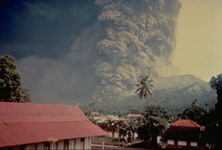 The largest historical eruption of Iya volcano took place in January 1969. During the course of a three-day eruption beginning on January 27 an eruption column reached 5 km above the volcano. Pyroclastic flows and lahars completely overran one village and damaged 7 others, destroying 287 houses.
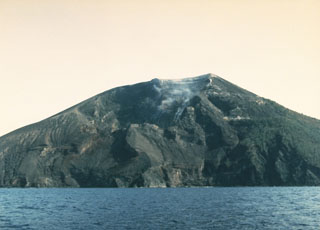 The southern side of the small Iya volcano in central Flores with a weak plume rising from a crater near the summit. Gunung Iya is the southernmost of three volcanoes forming a small peninsula south of Ende.
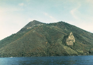 An old lava dome forms the light-colored feature at the right on the SE flank of Gunung Iya. It is part of a southernmost chain of cones forming a peninsula on the south-central coast of Flores Island.
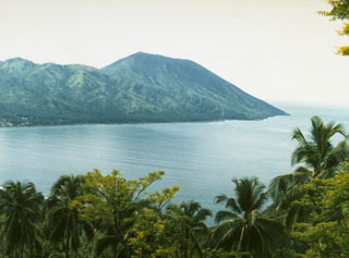 The small Iya volcano is at the southern end of a peninsula on central Flores Island, seen here from the village of Kori Bari on the NW. Intermittent explosive eruptions have been recorded since 1671.
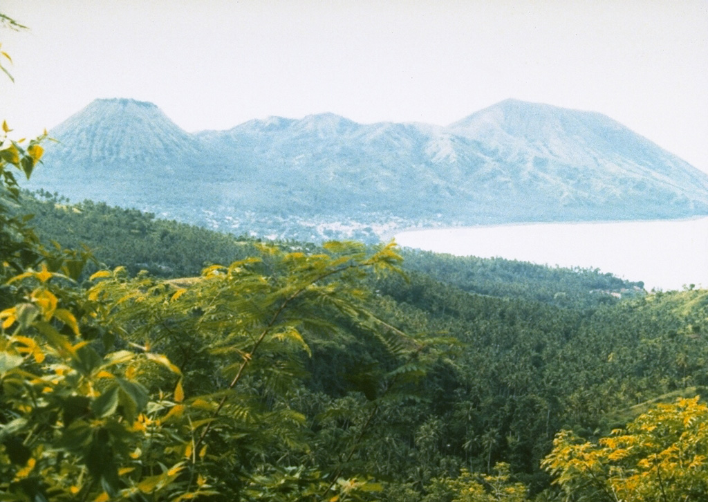
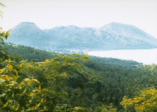 Gunung Iya (right), next to the Pui cone seen here at the left, is the southernmost of a group of three volcanoes forming a small peninsula on central Flores Island. It has shown eruptive activity in historical time with intermittent explosive eruptions recorded since 1671.
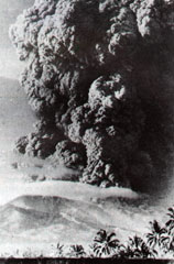 An ash plume rising above Iya is seen from Ende city on 27 January 1967. Iya erupted suddenly with no recognized precursory activity. The plume rose 5 km above the summit from a new 400-650 m wide crater on the upper SW flank, accompanied by a pyroclastic flow. Houses were damaged on the nearby island of Ende and one person was killed. Secondary lahars later caused another fatality in a village below the ash-covered cone of Raja. The eruption ended on 30 January.
There are no samples for Iya in the Smithsonian's NMNH Department of Mineral Sciences Rock and Ore collection.
| Copernicus Browser | The Copernicus Browser replaced the Sentinel Hub Playground browser in 2023, to provide access to Earth observation archives from the Copernicus Data Space Ecosystem, the main distribution platform for data from the EU Copernicus missions. |
| MIROVA | Middle InfraRed Observation of Volcanic Activity (MIROVA) is a near real time volcanic hot-spot detection system based on the analysis of MODIS (Moderate Resolution Imaging Spectroradiometer) data. In particular, MIROVA uses the Middle InfraRed Radiation (MIR), measured over target volcanoes, in order to detect, locate and measure the heat radiation sourced from volcanic activity. |
| MODVOLC Thermal Alerts | Using infrared satellite Moderate Resolution Imaging Spectroradiometer (MODIS) data, scientists at the Hawai'i Institute of Geophysics and Planetology, University of Hawai'i, developed an automated system called MODVOLC to map thermal hot-spots in near real time. For each MODIS image, the algorithm automatically scans each 1 km pixel within it to check for high-temperature hot-spots. When one is found the date, time, location, and intensity are recorded. MODIS looks at every square km of the Earth every 48 hours, once during the day and once during the night, and the presence of two MODIS sensors in space allows at least four hot-spot observations every two days. Each day updated global maps are compiled to display the locations of all hot spots detected in the previous 24 hours. There is a drop-down list with volcano names which allow users to 'zoom-in' and examine the distribution of hot-spots at a variety of spatial scales. |
|
WOVOdat
Single Volcano View Temporal Evolution of Unrest Side by Side Volcanoes |
WOVOdat is a database of volcanic unrest; instrumentally and visually recorded changes in seismicity, ground deformation, gas emission, and other parameters from their normal baselines. It is sponsored by the World Organization of Volcano Observatories (WOVO) and presently hosted at the Earth Observatory of Singapore.
GVMID Data on Volcano Monitoring Infrastructure The Global Volcano Monitoring Infrastructure Database GVMID, is aimed at documenting and improving capabilities of volcano monitoring from the ground and space. GVMID should provide a snapshot and baseline view of the techniques and instrumentation that are in place at various volcanoes, which can be use by volcano observatories as reference to setup new monitoring system or improving networks at a specific volcano. These data will allow identification of what monitoring gaps exist, which can be then targeted by remote sensing infrastructure and future instrument deployments. |
| Volcanic Hazard Maps | The IAVCEI Commission on Volcanic Hazards and Risk has a Volcanic Hazard Maps database designed to serve as a resource for hazard mappers (or other interested parties) to explore how common issues in hazard map development have been addressed at different volcanoes, in different countries, for different hazards, and for different intended audiences. In addition to the comprehensive, searchable Volcanic Hazard Maps Database, this website contains information about diversity of volcanic hazard maps, illustrated using examples from the database. This site is for educational purposes related to volcanic hazard maps. Hazard maps found on this website should not be used for emergency purposes. For the most recent, official hazard map for a particular volcano, please seek out the proper institutional authorities on the matter. |
| IRIS seismic stations/networks | Incorporated Research Institutions for Seismology (IRIS) Data Services map showing the location of seismic stations from all available networks (permanent or temporary) within a radius of 0.18° (about 20 km at mid-latitudes) from the given location of Iya. Users can customize a variety of filters and options in the left panel. Note that if there are no stations are known the map will default to show the entire world with a "No data matched request" error notice. |
| UNAVCO GPS/GNSS stations | Geodetic Data Services map from UNAVCO showing the location of GPS/GNSS stations from all available networks (permanent or temporary) within a radius of 20 km from the given location of Iya. Users can customize the data search based on station or network names, location, and time window. Requires Adobe Flash Player. |
| DECADE Data | The DECADE portal, still in the developmental stage, serves as an example of the proposed interoperability between The Smithsonian Institution's Global Volcanism Program, the Mapping Gas Emissions (MaGa) Database, and the EarthChem Geochemical Portal. The Deep Earth Carbon Degassing (DECADE) initiative seeks to use new and established technologies to determine accurate global fluxes of volcanic CO2 to the atmosphere, but installing CO2 monitoring networks on 20 of the world's 150 most actively degassing volcanoes. The group uses related laboratory-based studies (direct gas sampling and analysis, melt inclusions) to provide new data for direct degassing of deep earth carbon to the atmosphere. |
| Large Eruptions of Iya | Information about large Quaternary eruptions (VEI >= 4) is cataloged in the Large Magnitude Explosive Volcanic Eruptions (LaMEVE) database of the Volcano Global Risk Identification and Analysis Project (VOGRIPA). |
| EarthChem | EarthChem develops and maintains databases, software, and services that support the preservation, discovery, access and analysis of geochemical data, and facilitate their integration with the broad array of other available earth science parameters. EarthChem is operated by a joint team of disciplinary scientists, data scientists, data managers and information technology developers who are part of the NSF-funded data facility Integrated Earth Data Applications (IEDA). IEDA is a collaborative effort of EarthChem and the Marine Geoscience Data System (MGDS). |

