Volcanogenic carbon dioxide kills soldiers in a topographic depression
On 14 July press reports noted that a party of the Ground Self Defense Force (Japanese army) on a training mission at the N foot of Hakkoda volcano without gas masks accidentally inhaled dangerous gases. In the darkness, some members of the party slipped into a depression (18 m long, 11 m wide, and 8 m deep), as did those who first tried to rescue them. The men were hospitalized on the evening of 12 July, but three lost their lives. There were no plants within the depression, and leaves on plants around it were dead. The fire station of the Aomori Prefecture mentioned that many holes and depressions emitting sulfurous acidic gases were located around this volcano. Local farmers reported dead animals in these depressions.
According to J. Hirabayashi, who inspected the depression on 13 July, its gases contained as much as 15-20 volume percent CO2 (much higher than the normal value of 0.035%), but no hydrogen sulfide. Delta 13C values were -5.7 for CO2 in the gas from the depression collected on 13 July, -6.1 for CO2 dissolved in water samples from the Hakkoda hotsprings, and -6.0 in the springwater from near the depression, collected on 14 July. These results indicated a magmatic origin for the CO2-rich gas because delta 13C of CO2 in volcanic gas in Japan ranges from -10 to 0 , whereas that in CO2 gas of organic origin ranges from -30 to -20 .
Information Contacts: Takeshi Ohba and Jun-ichi Hirabayashi, Tokyo Institute of Technology, 2-12-1 O-okayama,Meguro-ku, Tokyo 152, Japan; Setsuya Nakada, Volcano Research Center, Earthquake Research Institute, University of Tokyo, Yayoi 1-1- 1, Bunkyo-ku, Tokyo 113, Japan (URL: http://www.eri.u-tokyo.ac.jp/VRC/index_E.html).
The Global Volcanism Program has no Weekly Reports available for Hakkodasan.
Reports are organized chronologically and indexed below by Month/Year (Publication Volume:Number), and include a one-line summary. Click on the index link or scroll down to read the reports.
Volcanogenic carbon dioxide kills soldiers in a topographic depression
On 14 July press reports noted that a party of the Ground Self Defense Force (Japanese army) on a training mission at the N foot of Hakkoda volcano without gas masks accidentally inhaled dangerous gases. In the darkness, some members of the party slipped into a depression (18 m long, 11 m wide, and 8 m deep), as did those who first tried to rescue them. The men were hospitalized on the evening of 12 July, but three lost their lives. There were no plants within the depression, and leaves on plants around it were dead. The fire station of the Aomori Prefecture mentioned that many holes and depressions emitting sulfurous acidic gases were located around this volcano. Local farmers reported dead animals in these depressions.
According to J. Hirabayashi, who inspected the depression on 13 July, its gases contained as much as 15-20 volume percent CO2 (much higher than the normal value of 0.035%), but no hydrogen sulfide. Delta 13C values were -5.7 for CO2 in the gas from the depression collected on 13 July, -6.1 for CO2 dissolved in water samples from the Hakkoda hotsprings, and -6.0 in the springwater from near the depression, collected on 14 July. These results indicated a magmatic origin for the CO2-rich gas because delta 13C of CO2 in volcanic gas in Japan ranges from -10 to 0 , whereas that in CO2 gas of organic origin ranges from -30 to -20 .
Information Contacts: Takeshi Ohba and Jun-ichi Hirabayashi, Tokyo Institute of Technology, 2-12-1 O-okayama,Meguro-ku, Tokyo 152, Japan; Setsuya Nakada, Volcano Research Center, Earthquake Research Institute, University of Tokyo, Yayoi 1-1- 1, Bunkyo-ku, Tokyo 113, Japan (URL: http://www.eri.u-tokyo.ac.jp/VRC/index_E.html).
|
|
||||||||||||||||||||||||||
There is data available for 7 confirmed eruptive periods.
1550 ± 100 years Confirmed Eruption (Explosive / Effusive) VEI: 1
| Episode 1 | Eruption (Explosive / Effusive) | SW flank of O-dake (Jigoku-numa) | |||||||||||||||||||||||
|---|---|---|---|---|---|---|---|---|---|---|---|---|---|---|---|---|---|---|---|---|---|---|---|---|
| 1550 ± 100 years - Unknown | Evidence from Isotopic: 14C (calibrated) | |||||||||||||||||||||||
|
List of 3 Events for Episode 1 at SW flank of O-dake (Jigoku-numa)
|
||||||||||||||||||||||||
1340 ± 75 years Confirmed Eruption (Explosive / Effusive) VEI: 1
| Episode 1 | Eruption (Explosive / Effusive) | SW flank of O-dake (Jigoku-numa) | ||||||||||||||||||
|---|---|---|---|---|---|---|---|---|---|---|---|---|---|---|---|---|---|---|---|
| 1340 ± 75 years - Unknown | Evidence from Isotopic: 14C (calibrated) | ||||||||||||||||||
|
List of 2 Events for Episode 1 at SW flank of O-dake (Jigoku-numa)
|
|||||||||||||||||||
0450 (?) Confirmed Eruption (Explosive / Effusive) VEI: 1
| Episode 1 | Eruption (Explosive / Effusive) | O-dake, Hk-1 tephra | |||||||||||||||||||||||
|---|---|---|---|---|---|---|---|---|---|---|---|---|---|---|---|---|---|---|---|---|---|---|---|---|
| 0450 (?) - Unknown | Evidence from Isotopic: 14C (calibrated) | |||||||||||||||||||||||
|
List of 3 Events for Episode 1 at O-dake, Hk-1 tephra
|
||||||||||||||||||||||||
0050 BCE (?) Confirmed Eruption (Explosive / Effusive) VEI: 1
| Episode 1 | Eruption (Explosive / Effusive) | O-dake, Hk-2 tephra | |||||||||||||||||||||||
|---|---|---|---|---|---|---|---|---|---|---|---|---|---|---|---|---|---|---|---|---|---|---|---|---|
| 0050 BCE (?) - Unknown | Evidence from Isotopic: 14C (calibrated) | |||||||||||||||||||||||
|
List of 3 Events for Episode 1 at O-dake, Hk-2 tephra
|
||||||||||||||||||||||||
1150 BCE (?) Confirmed Eruption (Explosive / Effusive) VEI: 1
| Episode 1 | Eruption (Explosive / Effusive) | O-dake, Hk-3 tephra | |||||||||||||||||||||||
|---|---|---|---|---|---|---|---|---|---|---|---|---|---|---|---|---|---|---|---|---|---|---|---|---|
| 1150 BCE (?) - Unknown | Evidence from Isotopic: 14C (calibrated) | |||||||||||||||||||||||
|
List of 3 Events for Episode 1 at O-dake, Hk-3 tephra
|
||||||||||||||||||||||||
2250 BCE (?) Confirmed Eruption (Explosive / Effusive) VEI: 3
| Episode 1 | Eruption (Explosive / Effusive) | O-dake, Hk-4 tephra | ||||||||||||||||||||||||||||
|---|---|---|---|---|---|---|---|---|---|---|---|---|---|---|---|---|---|---|---|---|---|---|---|---|---|---|---|---|---|
| 2250 BCE (?) - Unknown | Evidence from Isotopic: 14C (calibrated) | ||||||||||||||||||||||||||||
|
List of 4 Events for Episode 1 at O-dake, Hk-4 tephra
|
|||||||||||||||||||||||||||||
2850 BCE (?) Confirmed Eruption (Explosive / Effusive) VEI: 2
| Episode 1 | Eruption (Explosive / Effusive) | O-dake, Hk-5 tephra | ||||||||||||||||||||||||||||
|---|---|---|---|---|---|---|---|---|---|---|---|---|---|---|---|---|---|---|---|---|---|---|---|---|---|---|---|---|---|
| 2850 BCE (?) - Unknown | Evidence from Isotopic: 14C (calibrated) | ||||||||||||||||||||||||||||
|
List of 4 Events for Episode 1 at O-dake, Hk-5 tephra
|
|||||||||||||||||||||||||||||
This compilation of synonyms and subsidiary features may not be comprehensive. Features are organized into four major categories: Cones, Craters, Domes, and Thermal Features. Synonyms of features appear indented below the primary name. In some cases additional feature type, elevation, or location details are provided.
Synonyms |
||||
| Hakkoda Group | ||||
Cones |
||||
| Feature Name | Feature Type | Elevation | Latitude | Longitude |
| Akakuradake | Cone | 1542 m | 40° 40' 5.00" N | 140° 52' 58.00" E |
| Hakkoda-Odake
Odake |
Stratovolcano | 1575 m | 40° 39' 30.00" N | 140° 52' 42.00" E |
| Hinatatake | Cone | 1245 m | 40° 39' 38.00" N | 140° 55' 29.00" E |
| Idodake | Cone | 1519 m | 40° 39' 56.00" N | 140° 52' 41.00" E |
| Iodake | Cone | 1364 m | 40° 38' 43.00" N | 140° 52' 36.00" E |
| Ishikuradake | Cone | 1201 m | 40° 38' 19.00" N | 140° 52' 38.00" E |
| Kodake | Cone | 1480 m | 40° 39' 10.00" N | 140° 53' 18.00" E |
| Takada-Odake | Stratovolcano | 1544 m | 40° 39' 10.00" N | 140° 54' 30.00" E |
| Tsurugidake
Turugidake |
Cone | |||
Craters |
||||
| Feature Name | Feature Type | Elevation | Latitude | Longitude |
| Jigokunuma | Crater | |||
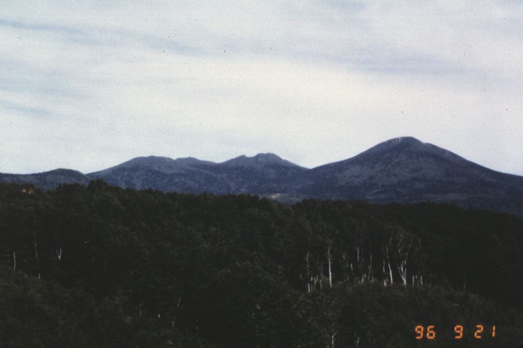
 Hakkoda consists of a group of 14 cones and lava domes south of Mutsu Bay at the northern end of Honshu. The NE rim of an 8-km-wide Pleistocene caldera forms an arcuate ridge across the caldera floor to the NE of the Hakkoda group volcanoes, which bury the SE caldera wall. This view looks from the W towards the northern Akakuradake, Idodake, and Hakkodasan volcanoes seen from left to right.
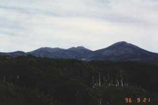
 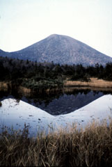 The Takada-Odake cone, seen here from Suren swamp to the S, is one a group of cones and lava domes forming the Hakkodasan volcano group in northernmost Honshu. Takada-Odake and other nearby volcanoes were constructed within an 8-km-wide caldera.
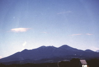 The Hakkodasan volcano group forms the skyline SE of the northern Honshu city of Aomori and is located within an 8-km-wide caldera. From left to right, the peaks are Takada-Odake, Akakuradake, Idodake, and Hakkoda-Odake (the highest peak of the complex, at the right-center).
 There are no samples for Hakkodasan in the Smithsonian's NMNH Department of Mineral Sciences Rock and Ore collection.
| Copernicus Browser | The Copernicus Browser replaced the Sentinel Hub Playground browser in 2023, to provide access to Earth observation archives from the Copernicus Data Space Ecosystem, the main distribution platform for data from the EU Copernicus missions. |
| MIROVA | Middle InfraRed Observation of Volcanic Activity (MIROVA) is a near real time volcanic hot-spot detection system based on the analysis of MODIS (Moderate Resolution Imaging Spectroradiometer) data. In particular, MIROVA uses the Middle InfraRed Radiation (MIR), measured over target volcanoes, in order to detect, locate and measure the heat radiation sourced from volcanic activity. |
| MODVOLC Thermal Alerts | Using infrared satellite Moderate Resolution Imaging Spectroradiometer (MODIS) data, scientists at the Hawai'i Institute of Geophysics and Planetology, University of Hawai'i, developed an automated system called MODVOLC to map thermal hot-spots in near real time. For each MODIS image, the algorithm automatically scans each 1 km pixel within it to check for high-temperature hot-spots. When one is found the date, time, location, and intensity are recorded. MODIS looks at every square km of the Earth every 48 hours, once during the day and once during the night, and the presence of two MODIS sensors in space allows at least four hot-spot observations every two days. Each day updated global maps are compiled to display the locations of all hot spots detected in the previous 24 hours. There is a drop-down list with volcano names which allow users to 'zoom-in' and examine the distribution of hot-spots at a variety of spatial scales. |
|
WOVOdat
Single Volcano View Temporal Evolution of Unrest Side by Side Volcanoes |
WOVOdat is a database of volcanic unrest; instrumentally and visually recorded changes in seismicity, ground deformation, gas emission, and other parameters from their normal baselines. It is sponsored by the World Organization of Volcano Observatories (WOVO) and presently hosted at the Earth Observatory of Singapore.
GVMID Data on Volcano Monitoring Infrastructure The Global Volcano Monitoring Infrastructure Database GVMID, is aimed at documenting and improving capabilities of volcano monitoring from the ground and space. GVMID should provide a snapshot and baseline view of the techniques and instrumentation that are in place at various volcanoes, which can be use by volcano observatories as reference to setup new monitoring system or improving networks at a specific volcano. These data will allow identification of what monitoring gaps exist, which can be then targeted by remote sensing infrastructure and future instrument deployments. |
| Volcanic Hazard Maps | The IAVCEI Commission on Volcanic Hazards and Risk has a Volcanic Hazard Maps database designed to serve as a resource for hazard mappers (or other interested parties) to explore how common issues in hazard map development have been addressed at different volcanoes, in different countries, for different hazards, and for different intended audiences. In addition to the comprehensive, searchable Volcanic Hazard Maps Database, this website contains information about diversity of volcanic hazard maps, illustrated using examples from the database. This site is for educational purposes related to volcanic hazard maps. Hazard maps found on this website should not be used for emergency purposes. For the most recent, official hazard map for a particular volcano, please seek out the proper institutional authorities on the matter. |
| IRIS seismic stations/networks | Incorporated Research Institutions for Seismology (IRIS) Data Services map showing the location of seismic stations from all available networks (permanent or temporary) within a radius of 0.18° (about 20 km at mid-latitudes) from the given location of Hakkodasan. Users can customize a variety of filters and options in the left panel. Note that if there are no stations are known the map will default to show the entire world with a "No data matched request" error notice. |
| UNAVCO GPS/GNSS stations | Geodetic Data Services map from UNAVCO showing the location of GPS/GNSS stations from all available networks (permanent or temporary) within a radius of 20 km from the given location of Hakkodasan. Users can customize the data search based on station or network names, location, and time window. Requires Adobe Flash Player. |
| DECADE Data | The DECADE portal, still in the developmental stage, serves as an example of the proposed interoperability between The Smithsonian Institution's Global Volcanism Program, the Mapping Gas Emissions (MaGa) Database, and the EarthChem Geochemical Portal. The Deep Earth Carbon Degassing (DECADE) initiative seeks to use new and established technologies to determine accurate global fluxes of volcanic CO2 to the atmosphere, but installing CO2 monitoring networks on 20 of the world's 150 most actively degassing volcanoes. The group uses related laboratory-based studies (direct gas sampling and analysis, melt inclusions) to provide new data for direct degassing of deep earth carbon to the atmosphere. |
| Large Eruptions of Hakkodasan | Information about large Quaternary eruptions (VEI >= 4) is cataloged in the Large Magnitude Explosive Volcanic Eruptions (LaMEVE) database of the Volcano Global Risk Identification and Analysis Project (VOGRIPA). |
| EarthChem | EarthChem develops and maintains databases, software, and services that support the preservation, discovery, access and analysis of geochemical data, and facilitate their integration with the broad array of other available earth science parameters. EarthChem is operated by a joint team of disciplinary scientists, data scientists, data managers and information technology developers who are part of the NSF-funded data facility Integrated Earth Data Applications (IEDA). IEDA is a collaborative effort of EarthChem and the Marine Geoscience Data System (MGDS). |

