
The US Geological Survey lowered both the Aviation Color Code and Volcano Alert Level for Ruby to Unassigned on 6 October, noting that eruptive activity was last detected during 14-15 September. The level of Unassigned reflected the lack of nearby monitoring instruments that could detect lower-level events.
Source: US Geological Survey
Submarine eruption during 14-16 September 2023
Ruby is a submarine volcano that rises to a depth of about 230 m and is located near the S end of the Mariana arc NW of Saipan. Sonar observations detected an eruption was detected in 1966. In 1995, submarine explosions were heard by fishermen, accompanied by a fish kill, sulfurous odors, bubbling water, and volcanic tremor (BGVN 20:10). This report covers a new eruption during September 2023 characterized by seismoacoustic signals and a discolored submarine plume based on reports from the United States Geological Survey (USGS).
During 14-15 September, seismoacoustic signals were detected and a submarine plume was observed in satellite imagery. Volcanic tremor was first observed on a seismometer around 1900 on 14 September. The USGS reported that another signal followed the tremor at 0016 on 15 September, which represented the start of the eruption. A submarine plume of discolored water was visible in geostationary satellite imagery starting around 0416 on 15 September. The discolored plume was also visible at 0650. Seismicity gradually increased throughout the day, peaking around 1426 with a M 4.7 earthquake. An analysis of seismoacoustic data from a geophysical monitoring station on Saipan (50 km SE) showed eruption signals beginning at 1427 on 15 September; the activity was also detected on other regional geophysical monitoring networks in the Pacific. Later in the day on 15 September, the submarine plume had notably weakened and became greener in color and narrower before detaching from the source vent at 1330 on 16 September. Local observers also reported seeing the plume of discolored water. Based on visuals in satellite images, and no additional activity was recorded by geophysical networks after 16 September; no gas-and-steam emissions were detected in satellite data associated with the eruption or in the following days. The Volcano Alert Level (VAL) was raised to Advisory (the second level on a four-level scale) and the Aviation Color Code (ACC) was raised to Yellow (the second level on a four-color scale) on 19 September. In a report issued on 20 September, USGS reported that there was no evidence of further activity detected in regional seismic and infrasound data. The discolored water plume had drifted slowly E and was still visible in satellite imagery in the ocean between Saipan and Anatahan through 25 September; during 21-23 September the discolored plume was visible in satellite imagery N and NNE of Saipan.
On 6 October the ACC and VAL were lowered to Unassigned, noting that eruptive activity was last detected during 14-15 September. The level of Unassigned reflected the lack of nearby monitoring instruments that could detect low-intensity events.
Information Contacts: US Geological Survey, Volcano Hazards Program (USGS-VHP), 12201 Sunrise Valley Drive, Reston, VA, USA, https://volcanoes.usgs.gov/index.html.
The US Geological Survey lowered both the Aviation Color Code and Volcano Alert Level for Ruby to Unassigned on 6 October, noting that eruptive activity was last detected during 14-15 September. The level of Unassigned reflected the lack of nearby monitoring instruments that could detect lower-level events.
Source: US Geological Survey
The US Geological Survey reported that no activity had been detected at Ruby in regional seismic and infrasound data or in satellite imagery since the 14-16 September submarine eruption. The plume of discolored water that had detached from the source vent on 16 September drifted E and dispersed; it was between Saipan and Anatahan during 21-22 September, faintly visible N and NNE of Saipan during 23-25 September, and no longer visible by 26 September. The Volcano Alert Level remained at Advisory (the second level on a four-level scale) and the Aviation Color Code remained at Yellow (the second level on a four-color scale).
Source: US Geological Survey
The US Geological Survey reported that an eruption began at Ruby on 15 September. A submarine plume of discolored water was identified in satellite images at around 0650 but there was no activity above the water surface. Eruption signals began at 1427 on 15 September based on retrospective analysis of seismo-acoustic data from a geophysical monitoring station on Saipan, 50 km SE. The activity was also recorded on other regional geophysical monitoring networks in the Pacific. The submarine plume had detached from the source vent by the morning of 16 September and no additional activity was recorded by geophysical networks. The Volcano Alert Level was raised to Advisory (the second level on a four-level scale) and the Aviation Color Code was raised to Yellow (the second level on a four-color scale).
Source: US Geological Survey
Reports are organized chronologically and indexed below by Month/Year (Publication Volume:Number), and include a one-line summary. Click on the index link or scroll down to read the reports.
Submarine eruption
Ruby is a prominent, active submarine volcano in the Mariana Arc (2,300 km S of Tokyo) located NW of the Island of Saipan (figure 1). Although signs of an eruption were first noted by fishermen about 11 October, initial attempts to confirm their early observations failed. On 23 October fishermen reported that they could hear submarine explosions in that vicinity. A vessel from the Wildlife and Emergency Management Office of the Commonwealth of the Northern Mariana Islands confirmed these reports. An Associated Press news report stated that early on 25 October observers had seen dead fish and bubbles, and had smelled a sulfurous odor. On 27 October the Pacific Daily News reported the eruption site as 15°36'22"N, 145°34'33"E (15.6061°N, 145.5758°E). This spot clearly lies on the edifice identified by Bloomer and others (1989, p. 215) as Ruby....
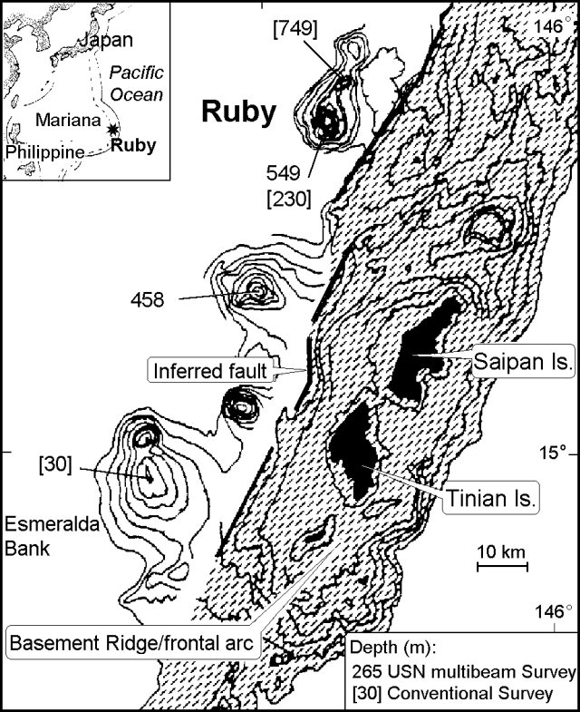 |
Figure 1. Index map and bathymetric map (depths in meters) showing seamounts near Saipan Island, including the known active centers Esmeralda Bank and Ruby (after Bloomer and others, 1989). |
Prior to the eruption, published estimates of the summit elevation suggested a 230-m depth, a refinement an earlier estimate of 549 m (Bloomer and others, 1989, p. 215). On 6 October 1995, the Pacific Daily News report stated the summit was measured at 185-m depth. This newly reported depth remains unconfirmed. According to Mike Blackford, on 23 October a marine depth finder reportedly measured a depth of ~60 m. Although this could be a reflection off the eruptive plume, in the absence of any discussion of instrument type and calibration, this depth remains equivocal.
According to Koyanagi and others (1993), the two seismic stations nearest the eruption were on Saipan (~50 km SE of Ruby) and Pagan islands (~130 km N of Saipan), both too distant to detect subtle seismic effects. Despite the lack of a nearby seismic station, tremor appeared on seismic records at the time of the eruption and the next day. Given the temporal coincidence between the eruption and the tremor, the two were probably associated.
A fish recovered at the eruption site was found to have small particles of ash in its gills and HVO researchers planned to analyze this ash. News of the eruption caused concern about a possible local tsunami and on 25 October, the Commonwealth of the Northern Mariana Islands issued an alert.
Evidence for Ruby's active status came from 1966 hydrophone data, followed later by dredging of extremely fresh volcanic rocks bearing plagioclase, clinopyroxene, and olivine (Bloomer and others, 1989).
References. Bloomer, S.H., Stern, R.J., and Smoot, N.C., 1989, Physical volcanology of the submarine Mariana and Volcano arcs: Bull. Volcanol., no. 51, p. 210-234.
Koyanagi, R., Kojima, G., Chong, F., and Chong, R., 1993, Seismic monitoring of earthquakes and volcanoes in the Northern Mariana Islands: 1993 summary report: Prepared for the Office of the Governor, Commonwealth of the Northern Mariana Islands, Capitol Hill, Saipan MP 96950 (revised 21 February 1993), 34 p.
Information Contacts: Robert J. Stern, Center for Lithospheric Studies, University of Texas at Dallas, Box 830688, Dallas, TX 75083-0688 USA; Robert Koyanagi, USGS Hawaiian Volcano Observatory, Hawaii Volcanoes National Park, HI 96718, USA; Ramon C. Chong, Commonwealth of the Northern Mariana Islands (CNMI), Disaster Control Office, Capitol Hill, Saipan, MP 96950 USA; Mike Blackford, Pacific Tsunami Warning Center, 91-270 Fort Weaver Road, Ewa Beach HI 96706, USA; Associated Press; Pacific Daily News.
Submarine eruption during 14-16 September 2023
Ruby is a submarine volcano that rises to a depth of about 230 m and is located near the S end of the Mariana arc NW of Saipan. Sonar observations detected an eruption was detected in 1966. In 1995, submarine explosions were heard by fishermen, accompanied by a fish kill, sulfurous odors, bubbling water, and volcanic tremor (BGVN 20:10). This report covers a new eruption during September 2023 characterized by seismoacoustic signals and a discolored submarine plume based on reports from the United States Geological Survey (USGS).
During 14-15 September, seismoacoustic signals were detected and a submarine plume was observed in satellite imagery. Volcanic tremor was first observed on a seismometer around 1900 on 14 September. The USGS reported that another signal followed the tremor at 0016 on 15 September, which represented the start of the eruption. A submarine plume of discolored water was visible in geostationary satellite imagery starting around 0416 on 15 September. The discolored plume was also visible at 0650. Seismicity gradually increased throughout the day, peaking around 1426 with a M 4.7 earthquake. An analysis of seismoacoustic data from a geophysical monitoring station on Saipan (50 km SE) showed eruption signals beginning at 1427 on 15 September; the activity was also detected on other regional geophysical monitoring networks in the Pacific. Later in the day on 15 September, the submarine plume had notably weakened and became greener in color and narrower before detaching from the source vent at 1330 on 16 September. Local observers also reported seeing the plume of discolored water. Based on visuals in satellite images, and no additional activity was recorded by geophysical networks after 16 September; no gas-and-steam emissions were detected in satellite data associated with the eruption or in the following days. The Volcano Alert Level (VAL) was raised to Advisory (the second level on a four-level scale) and the Aviation Color Code (ACC) was raised to Yellow (the second level on a four-color scale) on 19 September. In a report issued on 20 September, USGS reported that there was no evidence of further activity detected in regional seismic and infrasound data. The discolored water plume had drifted slowly E and was still visible in satellite imagery in the ocean between Saipan and Anatahan through 25 September; during 21-23 September the discolored plume was visible in satellite imagery N and NNE of Saipan.
On 6 October the ACC and VAL were lowered to Unassigned, noting that eruptive activity was last detected during 14-15 September. The level of Unassigned reflected the lack of nearby monitoring instruments that could detect low-intensity events.
Information Contacts: US Geological Survey, Volcano Hazards Program (USGS-VHP), 12201 Sunrise Valley Drive, Reston, VA, USA, https://volcanoes.usgs.gov/index.html.
|
|
||||||||||||||||||||||||||
There is data available for 3 confirmed eruptive periods.
2023 Sep 14 - 2023 Sep 15 Confirmed Eruption (Submarine) VEI: 1
| Episode 1 | Eruption (Submarine) | ||||||||||||||||||||||||
|---|---|---|---|---|---|---|---|---|---|---|---|---|---|---|---|---|---|---|---|---|---|---|---|---|
| 2023 Sep 14 - 2023 Sep 15 | Evidence from Observations: Reported | |||||||||||||||||||||||
|
List of 3 Events for Episode 1
|
||||||||||||||||||||||||
1995 Oct 11 (?) - 1995 Oct 25 Confirmed Eruption (Submarine) VEI: 1
| Episode 1 | Eruption (Submarine) | ||||||||||||||||||||||||
|---|---|---|---|---|---|---|---|---|---|---|---|---|---|---|---|---|---|---|---|---|---|---|---|---|
| 1995 Oct 11 (?) - 1995 Oct 25 | Evidence from Observations: Reported | |||||||||||||||||||||||
|
List of 3 Events for Episode 1
|
||||||||||||||||||||||||
1966 Apr 21 ± 7 days - 1966 May 16 ± 15 days Confirmed Eruption (Submarine) VEI: 1
| Episode 1 | Eruption (Submarine) | |||||||||||||||||||
|---|---|---|---|---|---|---|---|---|---|---|---|---|---|---|---|---|---|---|---|
| 1966 Apr 21 ± 7 days - 1966 May 16 ± 15 days | Evidence from Observations: Hydrophonic | ||||||||||||||||||
|
List of 2 Events for Episode 1
|
|||||||||||||||||||
The Global Volcanism Program has no synonyms or subfeatures listed for Ruby.
There are no samples for Ruby in the Smithsonian's NMNH Department of Mineral Sciences Rock and Ore collection.
| Copernicus Browser | The Copernicus Browser replaced the Sentinel Hub Playground browser in 2023, to provide access to Earth observation archives from the Copernicus Data Space Ecosystem, the main distribution platform for data from the EU Copernicus missions. |
| MIROVA | Middle InfraRed Observation of Volcanic Activity (MIROVA) is a near real time volcanic hot-spot detection system based on the analysis of MODIS (Moderate Resolution Imaging Spectroradiometer) data. In particular, MIROVA uses the Middle InfraRed Radiation (MIR), measured over target volcanoes, in order to detect, locate and measure the heat radiation sourced from volcanic activity. |
| MODVOLC Thermal Alerts | Using infrared satellite Moderate Resolution Imaging Spectroradiometer (MODIS) data, scientists at the Hawai'i Institute of Geophysics and Planetology, University of Hawai'i, developed an automated system called MODVOLC to map thermal hot-spots in near real time. For each MODIS image, the algorithm automatically scans each 1 km pixel within it to check for high-temperature hot-spots. When one is found the date, time, location, and intensity are recorded. MODIS looks at every square km of the Earth every 48 hours, once during the day and once during the night, and the presence of two MODIS sensors in space allows at least four hot-spot observations every two days. Each day updated global maps are compiled to display the locations of all hot spots detected in the previous 24 hours. There is a drop-down list with volcano names which allow users to 'zoom-in' and examine the distribution of hot-spots at a variety of spatial scales. |
|
WOVOdat
Single Volcano View Temporal Evolution of Unrest Side by Side Volcanoes |
WOVOdat is a database of volcanic unrest; instrumentally and visually recorded changes in seismicity, ground deformation, gas emission, and other parameters from their normal baselines. It is sponsored by the World Organization of Volcano Observatories (WOVO) and presently hosted at the Earth Observatory of Singapore.
GVMID Data on Volcano Monitoring Infrastructure The Global Volcano Monitoring Infrastructure Database GVMID, is aimed at documenting and improving capabilities of volcano monitoring from the ground and space. GVMID should provide a snapshot and baseline view of the techniques and instrumentation that are in place at various volcanoes, which can be use by volcano observatories as reference to setup new monitoring system or improving networks at a specific volcano. These data will allow identification of what monitoring gaps exist, which can be then targeted by remote sensing infrastructure and future instrument deployments. |
| Volcanic Hazard Maps | The IAVCEI Commission on Volcanic Hazards and Risk has a Volcanic Hazard Maps database designed to serve as a resource for hazard mappers (or other interested parties) to explore how common issues in hazard map development have been addressed at different volcanoes, in different countries, for different hazards, and for different intended audiences. In addition to the comprehensive, searchable Volcanic Hazard Maps Database, this website contains information about diversity of volcanic hazard maps, illustrated using examples from the database. This site is for educational purposes related to volcanic hazard maps. Hazard maps found on this website should not be used for emergency purposes. For the most recent, official hazard map for a particular volcano, please seek out the proper institutional authorities on the matter. |
| IRIS seismic stations/networks | Incorporated Research Institutions for Seismology (IRIS) Data Services map showing the location of seismic stations from all available networks (permanent or temporary) within a radius of 0.18° (about 20 km at mid-latitudes) from the given location of Ruby. Users can customize a variety of filters and options in the left panel. Note that if there are no stations are known the map will default to show the entire world with a "No data matched request" error notice. |
| UNAVCO GPS/GNSS stations | Geodetic Data Services map from UNAVCO showing the location of GPS/GNSS stations from all available networks (permanent or temporary) within a radius of 20 km from the given location of Ruby. Users can customize the data search based on station or network names, location, and time window. Requires Adobe Flash Player. |
| DECADE Data | The DECADE portal, still in the developmental stage, serves as an example of the proposed interoperability between The Smithsonian Institution's Global Volcanism Program, the Mapping Gas Emissions (MaGa) Database, and the EarthChem Geochemical Portal. The Deep Earth Carbon Degassing (DECADE) initiative seeks to use new and established technologies to determine accurate global fluxes of volcanic CO2 to the atmosphere, but installing CO2 monitoring networks on 20 of the world's 150 most actively degassing volcanoes. The group uses related laboratory-based studies (direct gas sampling and analysis, melt inclusions) to provide new data for direct degassing of deep earth carbon to the atmosphere. |
| Large Eruptions of Ruby | Information about large Quaternary eruptions (VEI >= 4) is cataloged in the Large Magnitude Explosive Volcanic Eruptions (LaMEVE) database of the Volcano Global Risk Identification and Analysis Project (VOGRIPA). |
| EarthChem | EarthChem develops and maintains databases, software, and services that support the preservation, discovery, access and analysis of geochemical data, and facilitate their integration with the broad array of other available earth science parameters. EarthChem is operated by a joint team of disciplinary scientists, data scientists, data managers and information technology developers who are part of the NSF-funded data facility Integrated Earth Data Applications (IEDA). IEDA is a collaborative effort of EarthChem and the Marine Geoscience Data System (MGDS). |


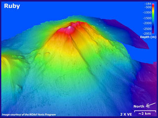 Ruby submarine volcano in the southern Mariana arc is seen in this bathymetric data looking from the NW with 2x vertical exaggeration. Depths in this image range from 184 to 2,955 m, and it rises to within 230 m of the ocean surface NW of Saipan. There was an eruption detected in 1966 by sonar signals. In 1995 submarine explosions were heard, accompanied by a fish kill, sulfurous odors, bubbling water, and the detection of volcanic tremor.