Moderate fumarolic activity
Between 12 October and 2 November 1986, moderate fumarolic activity was observed in the E part of the summit crater. The fumaroles fell along a N-S line that divided the crater. The rest of the crater was snow-covered.
Information Contacts: G. Steinberg and B. Piskunov, Yuzhno-Sakhalinsk.
The Global Volcanism Program has no Weekly Reports available for Fuss Peak.
Reports are organized chronologically and indexed below by Month/Year (Publication Volume:Number), and include a one-line summary. Click on the index link or scroll down to read the reports.
Increased thermal activity
Recent aerial infrared surveys and ground investigations have shown increasing thermal activity at Fuss Peak. Gorshkov (1967) reported that there was no fumarolic activity at the volcano, E. K. Markhinin found only very minor signs of it in 1969, and fumaroles were not observed during 1971-1976 overflights. In 1973, an aerial infrared survey detected weak thermal anomalies over an area of about 104 m2 in the N and E parts of the crater and on its E rim (Gusev and Zelenov, 1979). When the volcano was resurveyed in 1978, intense thermal anomalies were measured over most of the 700-m-diameter crater, extending down to its bottom about 200 m below the rim. Weak fumaroles were observed in the E and central part of the crater. The 1978 resurvey also found a 50-80 m-wide zone of anomalously high temperatures extending 250-300 m down the E flank from the crater rim (Gusev and Zelenov, 1979). Fumaroles were seen on the E flank during an overflight in the fall of 1981.
G. S. Steinberg visited the volcano in September 1982 and found fumaroles at the base of both the W and E sides of the crater's small median ridge. Activity was stronger at the E base of the ridge, where there were two groups of fumaroles, each with three powerful vapor jets with temperatures of 95-96°C. Bright yellow sulfur crystals were present in some of the vents. Despite the fumaroles, the majority of the crater floor was snow-covered. Many weak fumaroles were observed in a zone of small fissures on the upper flank in the immediate vicinity of the crater rim, but none had deposited sulfur. About halfway down the cone, in a narrow, shallow canyon that was apparently an extension of the upper flank fissure zone, there were three groups of fumaroles, separated by 30-60 m, vigorously emitting a mixture of steam and other gases. Temperatures at these vents were 94-96°C and they had deposited bright yellow sulfur. Within the fissure zone, temperatures at 30-40 cm depth were 9-13°C. Temperatures at similar depths outside the zone were 3-4°C.
References. Gorshkov, G.S., 1967, Vulkanizm Kurilskoi Ostrovnoi Dugi: Nauka, Moscow, 288 p.
Gusev, N.A., and Zelenov, E.N., 1979, The activization of heat regime of the Fuss Peak volcano according to the heat aerial surveying: Volcanology and Seismology, no. 4, p. 102.
Information Contacts: G. Steinberg, Sakhalin Complex Institute.
Moderate fumarolic activity
Between 12 October and 2 November 1986, moderate fumarolic activity was observed in the E part of the summit crater. The fumaroles fell along a N-S line that divided the crater. The rest of the crater was snow-covered.
Information Contacts: G. Steinberg and B. Piskunov, Yuzhno-Sakhalinsk.
|
|
||||||||||||||||||||||||||
There is data available for 9 confirmed eruptive periods.
[ 1933 ] Uncertain Eruption
| Episode 1 | Eruption (Explosive / Effusive) | |||||||||||||||||||
|---|---|---|---|---|---|---|---|---|---|---|---|---|---|---|---|---|---|---|---|
| 1933 - Unknown | Evidence from Unknown | ||||||||||||||||||
|
List of 2 Events for Episode 1
|
|||||||||||||||||||
1854 Jul 5 Confirmed Eruption (Explosive / Effusive) VEI: 3
| Episode 1 | Eruption (Explosive / Effusive) | |||||||||||||||||||
|---|---|---|---|---|---|---|---|---|---|---|---|---|---|---|---|---|---|---|---|
| 1854 Jul 5 - Unknown | Evidence from Observations: Reported | ||||||||||||||||||
|
List of 2 Events for Episode 1
|
|||||||||||||||||||
[ 1742 ] Uncertain Eruption
| Episode 1 | Eruption (Explosive / Effusive) | |||||||||||||||||||
|---|---|---|---|---|---|---|---|---|---|---|---|---|---|---|---|---|---|---|---|
| 1742 - Unknown | Evidence from Unknown | ||||||||||||||||||
|
List of 2 Events for Episode 1
|
|||||||||||||||||||
1250 (?) Confirmed Eruption (Explosive / Effusive) VEI: 3 (?)
| Episode 1 | Eruption (Explosive / Effusive) | HPM1 tephra | |||||||||||||||||||||||
|---|---|---|---|---|---|---|---|---|---|---|---|---|---|---|---|---|---|---|---|---|---|---|---|---|
| 1250 (?) - Unknown | Evidence from Correlation: Tephrochronology | |||||||||||||||||||||||
|
List of 3 Events for Episode 1 at HPM1 tephra
|
||||||||||||||||||||||||
1590 BCE ± 70 years Confirmed Eruption (Explosive / Effusive) VEI: 3
| Episode 1 | Eruption (Explosive / Effusive) | HPM2 tephra | |||||||||||||||||||||||
|---|---|---|---|---|---|---|---|---|---|---|---|---|---|---|---|---|---|---|---|---|---|---|---|---|
| 1590 BCE ± 70 years - Unknown | Evidence from Isotopic: 14C (calibrated) | |||||||||||||||||||||||
|
List of 3 Events for Episode 1 at HPM2 tephra
|
||||||||||||||||||||||||
1850 BCE (?) Confirmed Eruption (Explosive / Effusive) VEI: 1 (?)
| Episode 1 | Eruption (Explosive / Effusive) | HPM3 tephra | |||||||||||||||||||||||
|---|---|---|---|---|---|---|---|---|---|---|---|---|---|---|---|---|---|---|---|---|---|---|---|---|
| 1850 BCE (?) - Unknown | Evidence from Correlation: Tephrochronology | |||||||||||||||||||||||
|
List of 3 Events for Episode 1 at HPM3 tephra
|
||||||||||||||||||||||||
3150 BCE (?) Confirmed Eruption (Explosive / Effusive) VEI: 3 (?)
| Episode 1 | Eruption (Explosive / Effusive) | HPM4 tephra | |||||||||||||||||||||||
|---|---|---|---|---|---|---|---|---|---|---|---|---|---|---|---|---|---|---|---|---|---|---|---|---|
| 3150 BCE (?) - Unknown | Evidence from Correlation: Tephrochronology | |||||||||||||||||||||||
|
List of 3 Events for Episode 1 at HPM4 tephra
|
||||||||||||||||||||||||
3850 BCE (?) Confirmed Eruption (Explosive / Effusive) VEI: 2
| Episode 1 | Eruption (Explosive / Effusive) | HPM5 tephra | |||||||||||||||||||||||
|---|---|---|---|---|---|---|---|---|---|---|---|---|---|---|---|---|---|---|---|---|---|---|---|---|
| 3850 BCE (?) - Unknown | Evidence from Correlation: Tephrochronology | |||||||||||||||||||||||
|
List of 3 Events for Episode 1 at HPM5 tephra
|
||||||||||||||||||||||||
4850 BCE (?) Confirmed Eruption (Explosive / Effusive) VEI: 1 (?)
| Episode 1 | Eruption (Explosive / Effusive) | HPM7 tephra | |||||||||||||||||||||||
|---|---|---|---|---|---|---|---|---|---|---|---|---|---|---|---|---|---|---|---|---|---|---|---|---|
| 4850 BCE (?) - Unknown | Evidence from Correlation: Tephrochronology | |||||||||||||||||||||||
|
List of 3 Events for Episode 1 at HPM7 tephra
|
||||||||||||||||||||||||
5250 BCE (?) Confirmed Eruption (Explosive / Effusive) VEI: 2 (?)
| Episode 1 | Eruption (Explosive / Effusive) | HPM8 tephra | |||||||||||||||||||||||
|---|---|---|---|---|---|---|---|---|---|---|---|---|---|---|---|---|---|---|---|---|---|---|---|---|
| 5250 BCE (?) - Unknown | Evidence from Correlation: Tephrochronology | |||||||||||||||||||||||
|
List of 3 Events for Episode 1 at HPM8 tephra
|
||||||||||||||||||||||||
5340 BCE ± 30 years Confirmed Eruption (Explosive / Effusive) VEI: 3
| Episode 1 | Eruption (Explosive / Effusive) | HPM6 tephra | |||||||||||||||||||||||
|---|---|---|---|---|---|---|---|---|---|---|---|---|---|---|---|---|---|---|---|---|---|---|---|---|
| 5340 BCE ± 30 years - Unknown | Evidence from Isotopic: 14C (calibrated) | |||||||||||||||||||||||
|
List of 3 Events for Episode 1 at HPM6 tephra
|
||||||||||||||||||||||||
This compilation of synonyms and subsidiary features may not be comprehensive. Features are organized into four major categories: Cones, Craters, Domes, and Thermal Features. Synonyms of features appear indented below the primary name. In some cases additional feature type, elevation, or location details are provided.
Synonyms |
| Siriadziri | Shiriyajiri-dake | Shiriyaziri |
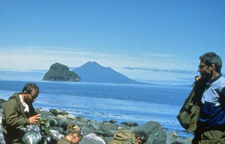 Fuss Peak in the distance forms a peninsula on the SW coast of Paramushir Island. The cone has a 700-m-wide, 300-m-deep crater. Well-preserved lava flows were emplaced on the middle and lower flanks, particularly on the E and SE sides. A volcanological field party in the foreground are on the shore of Shirinki Island.
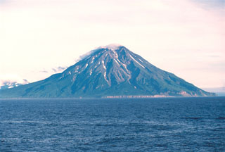 Fuss Peak forms a peninsula on the SW coast of Paramushir Island, the largest of the Kuril Islands. The cone has a 700-m-wide, 300-m-deep crater. A valley extends from a low point in the crater rim down to the coast on the NW flank.
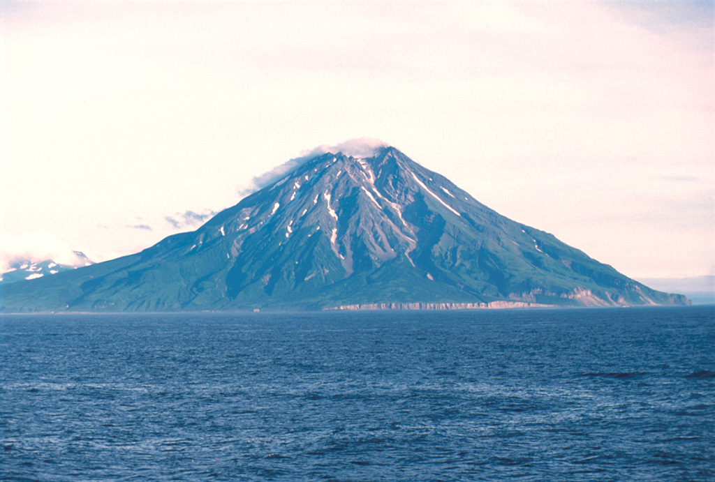
There are no samples for Fuss Peak in the Smithsonian's NMNH Department of Mineral Sciences Rock and Ore collection.
| Copernicus Browser | The Copernicus Browser replaced the Sentinel Hub Playground browser in 2023, to provide access to Earth observation archives from the Copernicus Data Space Ecosystem, the main distribution platform for data from the EU Copernicus missions. |
| MIROVA | Middle InfraRed Observation of Volcanic Activity (MIROVA) is a near real time volcanic hot-spot detection system based on the analysis of MODIS (Moderate Resolution Imaging Spectroradiometer) data. In particular, MIROVA uses the Middle InfraRed Radiation (MIR), measured over target volcanoes, in order to detect, locate and measure the heat radiation sourced from volcanic activity. |
| MODVOLC Thermal Alerts | Using infrared satellite Moderate Resolution Imaging Spectroradiometer (MODIS) data, scientists at the Hawai'i Institute of Geophysics and Planetology, University of Hawai'i, developed an automated system called MODVOLC to map thermal hot-spots in near real time. For each MODIS image, the algorithm automatically scans each 1 km pixel within it to check for high-temperature hot-spots. When one is found the date, time, location, and intensity are recorded. MODIS looks at every square km of the Earth every 48 hours, once during the day and once during the night, and the presence of two MODIS sensors in space allows at least four hot-spot observations every two days. Each day updated global maps are compiled to display the locations of all hot spots detected in the previous 24 hours. There is a drop-down list with volcano names which allow users to 'zoom-in' and examine the distribution of hot-spots at a variety of spatial scales. |
|
WOVOdat
Single Volcano View Temporal Evolution of Unrest Side by Side Volcanoes |
WOVOdat is a database of volcanic unrest; instrumentally and visually recorded changes in seismicity, ground deformation, gas emission, and other parameters from their normal baselines. It is sponsored by the World Organization of Volcano Observatories (WOVO) and presently hosted at the Earth Observatory of Singapore.
GVMID Data on Volcano Monitoring Infrastructure The Global Volcano Monitoring Infrastructure Database GVMID, is aimed at documenting and improving capabilities of volcano monitoring from the ground and space. GVMID should provide a snapshot and baseline view of the techniques and instrumentation that are in place at various volcanoes, which can be use by volcano observatories as reference to setup new monitoring system or improving networks at a specific volcano. These data will allow identification of what monitoring gaps exist, which can be then targeted by remote sensing infrastructure and future instrument deployments. |
| Volcanic Hazard Maps | The IAVCEI Commission on Volcanic Hazards and Risk has a Volcanic Hazard Maps database designed to serve as a resource for hazard mappers (or other interested parties) to explore how common issues in hazard map development have been addressed at different volcanoes, in different countries, for different hazards, and for different intended audiences. In addition to the comprehensive, searchable Volcanic Hazard Maps Database, this website contains information about diversity of volcanic hazard maps, illustrated using examples from the database. This site is for educational purposes related to volcanic hazard maps. Hazard maps found on this website should not be used for emergency purposes. For the most recent, official hazard map for a particular volcano, please seek out the proper institutional authorities on the matter. |
| IRIS seismic stations/networks | Incorporated Research Institutions for Seismology (IRIS) Data Services map showing the location of seismic stations from all available networks (permanent or temporary) within a radius of 0.18° (about 20 km at mid-latitudes) from the given location of Fuss Peak. Users can customize a variety of filters and options in the left panel. Note that if there are no stations are known the map will default to show the entire world with a "No data matched request" error notice. |
| UNAVCO GPS/GNSS stations | Geodetic Data Services map from UNAVCO showing the location of GPS/GNSS stations from all available networks (permanent or temporary) within a radius of 20 km from the given location of Fuss Peak. Users can customize the data search based on station or network names, location, and time window. Requires Adobe Flash Player. |
| DECADE Data | The DECADE portal, still in the developmental stage, serves as an example of the proposed interoperability between The Smithsonian Institution's Global Volcanism Program, the Mapping Gas Emissions (MaGa) Database, and the EarthChem Geochemical Portal. The Deep Earth Carbon Degassing (DECADE) initiative seeks to use new and established technologies to determine accurate global fluxes of volcanic CO2 to the atmosphere, but installing CO2 monitoring networks on 20 of the world's 150 most actively degassing volcanoes. The group uses related laboratory-based studies (direct gas sampling and analysis, melt inclusions) to provide new data for direct degassing of deep earth carbon to the atmosphere. |
| Large Eruptions of Fuss Peak | Information about large Quaternary eruptions (VEI >= 4) is cataloged in the Large Magnitude Explosive Volcanic Eruptions (LaMEVE) database of the Volcano Global Risk Identification and Analysis Project (VOGRIPA). |
| EarthChem | EarthChem develops and maintains databases, software, and services that support the preservation, discovery, access and analysis of geochemical data, and facilitate their integration with the broad array of other available earth science parameters. EarthChem is operated by a joint team of disciplinary scientists, data scientists, data managers and information technology developers who are part of the NSF-funded data facility Integrated Earth Data Applications (IEDA). IEDA is a collaborative effort of EarthChem and the Marine Geoscience Data System (MGDS). |

