

Steam and ash plume
A steam cloud emerging from an upper flank vent . . . was seen from neighboring Amchitka Island on 1 June at about 1000. Ash began mixing with the steam after ~30 minutes, and steam and ash emission remained visible until weather conditions obscured the volcano 3 hours later. At about 1500, a Reeve Aleutian Airways pilot reported a steam plume rising to ~3.5 km altitude, associated with a dispersed gray haze at about the same altitude. Authorities issued a NOTAM. When a U.S. Fish and Wildlife Service (FWS) vessel traveled past the N and W sides of Kiska Island on 3 June, no ash was visible on flank snow cover, although some light snow might have fallen since the eruption. Steaming from the W vent appeared typical. A plume from Kiska was clearly evident on radar aboard the Soviet vessel RV Vulkanolog, as it passed ~200 km N of Kiska on 4 June at 0800. However, no ashfall was noted at the ship.
Information Contacts: AVO; Nikolai Seliverstov (chief of expedition, RVVulkanolog), IV; Eugene Yogodzinski (RVVulkanolog), Cornell Univ; Anchorage Times, AK.
The Global Volcanism Program has no Weekly Reports available for Kiska.
Reports are organized chronologically and indexed below by Month/Year (Publication Volume:Number), and include a one-line summary. Click on the index link or scroll down to read the reports.
Eruption generates ash and steam plumes; small lava flow
Card 0751 (12 September 1969) Ash and steam plumes and lava seen; source uncertain
"Last night the people on Amchitka visually sighted a volcano erupting about 50 miles NW of the island. It was on one of the smaller islands which they could not identify. They observed volcanic ash to approximately 1,200 feet and steam to about 12,000 feet. They visually sighted flames and lava last night at approximately 1000 GMT on 12 September. The eruption was observed at periods of about two minutes during the most active period of the volcanic activity." Positive identification of the erupting volcano has not yet been made.
Card 0752 (17 September 1969) Overflights identify Kiska as source of activity
The following was received via cable from D.B. Stone on 15 September. "Kiska volcano seen to be active. Much steam, strong sulfur smell, air temperature as recorded by aircraft 10°C higher over N tip of island than over adjacent sea. Unable to see other islands due to poor weather. Kiska likely source of events seen from Amchitka."
The following report is from a telephone conversation with L. Kerry on 16 September, 7:00 p.m. EDT. "The first report we had was the 12th of September from the people working on Amchitka Island, who called in and reported that there was steam and that it seemed to be throwing something up into the air. This wasn't happening on the afternoon of the 13th when our military plane flew over. These first reports were just visual reports from Amchitka and because of overcast skies, they could only see it occasionally in snatches. There were no explosions heard, or none were reported to us, and they didn't say if there was any eruption cloud. The plane definitely pinpointed the volcano on 'Little Kiska' island. They measured a definite rise in temperature from as close as they could get in the plane of 15°C; there was steam and there seemed to be evidence of a small lava flow. The latest report we have from witnesses on Amchitka seems to indicate that it is beginning to stop; and a pilot reported the volcano is down to just steam a day ago."
Information Contacts:
Card 0751 (12 September 1969) John B. Townshend, College Observatory, Coast and Geodetic Survey, College AK, USA.
Card 0752 (17 September 1969) D.B. Stone, Geophysical Institute, University of Alaska, College, AK; Leonard Kerry, Adak Observatory, FPO Seattle, WA.
Plume on satellite image
From a 15 April NOAA 9 satellite image (at 1704), Steven Shivers (USGS) noted a narrow plume drifting ~60 km E from the volcano. No reports of an eruption have been received from airplane pilots or ground observers.
Information Contacts: J. Reeder, ADGGS; T. Miller, USGS, Anchorage; W. Gould, NOAA/NESDIS.
Steam and ash plume
A steam cloud emerging from an upper flank vent . . . was seen from neighboring Amchitka Island on 1 June at about 1000. Ash began mixing with the steam after ~30 minutes, and steam and ash emission remained visible until weather conditions obscured the volcano 3 hours later. At about 1500, a Reeve Aleutian Airways pilot reported a steam plume rising to ~3.5 km altitude, associated with a dispersed gray haze at about the same altitude. Authorities issued a NOTAM. When a U.S. Fish and Wildlife Service (FWS) vessel traveled past the N and W sides of Kiska Island on 3 June, no ash was visible on flank snow cover, although some light snow might have fallen since the eruption. Steaming from the W vent appeared typical. A plume from Kiska was clearly evident on radar aboard the Soviet vessel RV Vulkanolog, as it passed ~200 km N of Kiska on 4 June at 0800. However, no ashfall was noted at the ship.
Information Contacts: AVO; Nikolai Seliverstov (chief of expedition, RVVulkanolog), IV; Eugene Yogodzinski (RVVulkanolog), Cornell Univ; Anchorage Times, AK.
|
|
||||||||||||||||||||||||||
There is data available for 4 confirmed eruptive periods.
1990 Jun 1 - 1990 Jun 1 (?) Confirmed Eruption (Explosive / Effusive) VEI: 2
| Episode 1 | Eruption (Explosive / Effusive) | Upper NW? flank | |||||||||||||||||||||||
|---|---|---|---|---|---|---|---|---|---|---|---|---|---|---|---|---|---|---|---|---|---|---|---|---|
| 1990 Jun 1 - 1990 Jun 1 (?) | Evidence from Observations: Reported | |||||||||||||||||||||||
|
List of 3 Events for Episode 1 at Upper NW? flank
|
||||||||||||||||||||||||
[ 1987 Apr 15 ] Uncertain Eruption
| Episode 1 | Eruption (Explosive / Effusive) | |||||||||||||||||||
|---|---|---|---|---|---|---|---|---|---|---|---|---|---|---|---|---|---|---|---|
| 1987 Apr 15 - Unknown | Evidence from Unknown | ||||||||||||||||||
|
List of 2 Events for Episode 1
|
|||||||||||||||||||
1969 Sep 11 - 1969 Sep 16 Confirmed Eruption (Explosive / Effusive) VEI: 2 (?)
| Episode 1 | Eruption (Explosive / Effusive) | |||||||||||||||||||||||||||||
|---|---|---|---|---|---|---|---|---|---|---|---|---|---|---|---|---|---|---|---|---|---|---|---|---|---|---|---|---|---|
| 1969 Sep 11 - 1969 Sep 16 | Evidence from Observations: Reported | ||||||||||||||||||||||||||||
|
List of 4 Events for Episode 1
|
|||||||||||||||||||||||||||||
1964 Mar 18 Confirmed Eruption (Explosive / Effusive) VEI: 0
| Episode 1 | Eruption (Explosive / Effusive) | |||||||||||||||||||
|---|---|---|---|---|---|---|---|---|---|---|---|---|---|---|---|---|---|---|---|
| 1964 Mar 18 - Unknown | Evidence from Observations: Reported | ||||||||||||||||||
|
List of 2 Events for Episode 1
|
|||||||||||||||||||
1962 Jan 24 Confirmed Eruption (Explosive / Effusive) VEI: 3
| Episode 1 | Eruption (Explosive / Effusive) | North flank (Sirius Point) | ||||||||||||||||||||||||||||
|---|---|---|---|---|---|---|---|---|---|---|---|---|---|---|---|---|---|---|---|---|---|---|---|---|---|---|---|---|---|
| 1962 Jan 24 - Unknown | Evidence from Observations: Reported | ||||||||||||||||||||||||||||
|
List of 4 Events for Episode 1 at North flank (Sirius Point)
|
|||||||||||||||||||||||||||||
[ 1927 ] Uncertain Eruption
| Episode 1 | Eruption (Explosive / Effusive) | |||||||||||||||||||
|---|---|---|---|---|---|---|---|---|---|---|---|---|---|---|---|---|---|---|---|
| 1927 - Unknown | Evidence from Unknown | ||||||||||||||||||
|
List of 2 Events for Episode 1
|
|||||||||||||||||||
[ 1907 ] Uncertain Eruption
| Episode 1 | Eruption (Explosive / Effusive) | |||||||||||||||||||
|---|---|---|---|---|---|---|---|---|---|---|---|---|---|---|---|---|---|---|---|
| 1907 - Unknown | Evidence from Unknown | ||||||||||||||||||
|
List of 2 Events for Episode 1
|
|||||||||||||||||||
This compilation of synonyms and subsidiary features may not be comprehensive. Features are organized into four major categories: Cones, Craters, Domes, and Thermal Features. Synonyms of features appear indented below the primary name. In some cases additional feature type, elevation, or location details are provided.
Synonyms |
| Kuska |
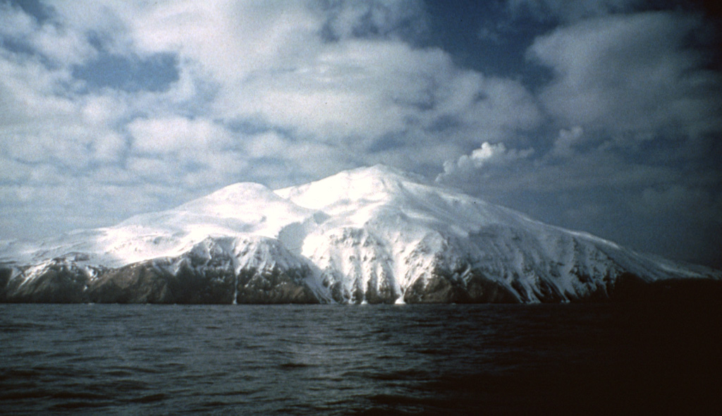
 A steam plume rises from the summit of Kiska, one of the westernmost historically active volcanoes of the Aleutian Arc. Three sides of the volcano, including the northern side seen here, are bounded by steep cliffs up to 450 m high. A scoria cone on the flank formed in 1962 at the northern coast.
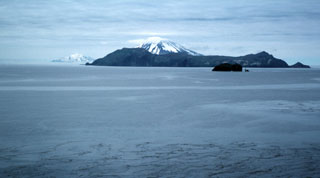 The view WNW from the western side of Little Sitkin Island includes the broad Davidof island, part of the rim of a largely submerged caldera across the right-center. The snow-capped peak behind Davidof is Segula volcano. In the background to the far left is the Kiska volcano.
The following 27 samples associated with this volcano can be found in the Smithsonian's NMNH Department of Mineral Sciences collections, and may be availble for research (contact the Rock and Ore Collections Manager). Catalog number links will open a window with more information.
| Catalog Number | Sample Description | Lava Source | Collection Date |
|---|---|---|---|
| NMNH 118206-1 | Andesite | -- | 11 Sep 2015 |
| NMNH 118206-10 | Andesite | -- | 9 Sep 2015 |
| NMNH 118206-11 | Andesite | -- | 9 Sep 2015 |
| NMNH 118206-12 | Andesite | -- | 9 Sep 2015 |
| NMNH 118206-13 | Block | -- | 9 Sep 2015 |
| NMNH 118206-14 | Block | -- | 9 Sep 2015 |
| NMNH 118206-15 | Andesite | -- | 9 Sep 2015 |
| NMNH 118206-16 | Andesite | -- | 9 Sep 2015 |
| NMNH 118206-17 | Andesite | -- | 9 Sep 2015 |
| NMNH 118206-18 | Andesite | -- | 9 Sep 2015 |
| NMNH 118206-19 | Basaltic Andesite | -- | 9 Sep 2015 |
| NMNH 118206-2 | Andesite | -- | 11 Sep 2015 |
| NMNH 118206-20 | Bomb | -- | 10 Sep 2015 |
| NMNH 118206-21 | Spatter | -- | 10 Sep 2015 |
| NMNH 118206-22 | Spatter | -- | 10 Sep 2015 |
| NMNH 118206-23 | Andesite spatter | -- | 10 Sep 2015 |
| NMNH 118206-24 | Spatter | -- | 10 Sep 2015 |
| NMNH 118206-25 | Basaltic Andesite | -- | 10 Sep 2015 |
| NMNH 118206-26 | Basaltic Andesite | -- | 10 Sep 2015 |
| NMNH 118206-3 | Basaltic Andesite | -- | 7 Sep 2015 |
| NMNH 118206-4 | Basaltic andesite breccia | -- | 7 Sep 2015 |
| NMNH 118206-5 | Andesite | -- | 11 Sep 2015 |
| NMNH 118206-6 | Andesite pyroclastic flow | -- | 11 Sep 2015 |
| NMNH 118206-7 | Lapilli tephra | -- | 8 Sep 2015 |
| NMNH 118206-8 | Lapilli tephra | -- | 8 Sep 2015 |
| NMNH 118206-9 | Volcanic Breccia | -- | 8 Sep 2015 |
| NMNH 76100 | Unidentified | -- | -- |
| Alaska Volcano Observatory (Link to Kiska) | The Alaska Volcano Observatory (AVO) is a joint program of the U.S. Geological Survey (USGS), the Geophysical Institute of the University of Alaska Fairbanks (UAFGI), and the State of Alaska Division of Geological and Geophysical Surveys (ADGGS). AVO was formed in 1988, and uses federal, state, and university resources to monitor and study Alaska's hazardous volcanoes, to predict and record eruptive activity, and to mitigate volcanic hazards to life and property. |
| Copernicus Browser | The Copernicus Browser replaced the Sentinel Hub Playground browser in 2023, to provide access to Earth observation archives from the Copernicus Data Space Ecosystem, the main distribution platform for data from the EU Copernicus missions. |
| MIROVA | Middle InfraRed Observation of Volcanic Activity (MIROVA) is a near real time volcanic hot-spot detection system based on the analysis of MODIS (Moderate Resolution Imaging Spectroradiometer) data. In particular, MIROVA uses the Middle InfraRed Radiation (MIR), measured over target volcanoes, in order to detect, locate and measure the heat radiation sourced from volcanic activity. |
| MODVOLC Thermal Alerts | Using infrared satellite Moderate Resolution Imaging Spectroradiometer (MODIS) data, scientists at the Hawai'i Institute of Geophysics and Planetology, University of Hawai'i, developed an automated system called MODVOLC to map thermal hot-spots in near real time. For each MODIS image, the algorithm automatically scans each 1 km pixel within it to check for high-temperature hot-spots. When one is found the date, time, location, and intensity are recorded. MODIS looks at every square km of the Earth every 48 hours, once during the day and once during the night, and the presence of two MODIS sensors in space allows at least four hot-spot observations every two days. Each day updated global maps are compiled to display the locations of all hot spots detected in the previous 24 hours. There is a drop-down list with volcano names which allow users to 'zoom-in' and examine the distribution of hot-spots at a variety of spatial scales. |
|
WOVOdat
Single Volcano View Temporal Evolution of Unrest Side by Side Volcanoes |
WOVOdat is a database of volcanic unrest; instrumentally and visually recorded changes in seismicity, ground deformation, gas emission, and other parameters from their normal baselines. It is sponsored by the World Organization of Volcano Observatories (WOVO) and presently hosted at the Earth Observatory of Singapore.
GVMID Data on Volcano Monitoring Infrastructure The Global Volcano Monitoring Infrastructure Database GVMID, is aimed at documenting and improving capabilities of volcano monitoring from the ground and space. GVMID should provide a snapshot and baseline view of the techniques and instrumentation that are in place at various volcanoes, which can be use by volcano observatories as reference to setup new monitoring system or improving networks at a specific volcano. These data will allow identification of what monitoring gaps exist, which can be then targeted by remote sensing infrastructure and future instrument deployments. |
| Volcanic Hazard Maps | The IAVCEI Commission on Volcanic Hazards and Risk has a Volcanic Hazard Maps database designed to serve as a resource for hazard mappers (or other interested parties) to explore how common issues in hazard map development have been addressed at different volcanoes, in different countries, for different hazards, and for different intended audiences. In addition to the comprehensive, searchable Volcanic Hazard Maps Database, this website contains information about diversity of volcanic hazard maps, illustrated using examples from the database. This site is for educational purposes related to volcanic hazard maps. Hazard maps found on this website should not be used for emergency purposes. For the most recent, official hazard map for a particular volcano, please seek out the proper institutional authorities on the matter. |
| IRIS seismic stations/networks | Incorporated Research Institutions for Seismology (IRIS) Data Services map showing the location of seismic stations from all available networks (permanent or temporary) within a radius of 0.18° (about 20 km at mid-latitudes) from the given location of Kiska. Users can customize a variety of filters and options in the left panel. Note that if there are no stations are known the map will default to show the entire world with a "No data matched request" error notice. |
| UNAVCO GPS/GNSS stations | Geodetic Data Services map from UNAVCO showing the location of GPS/GNSS stations from all available networks (permanent or temporary) within a radius of 20 km from the given location of Kiska. Users can customize the data search based on station or network names, location, and time window. Requires Adobe Flash Player. |
| DECADE Data | The DECADE portal, still in the developmental stage, serves as an example of the proposed interoperability between The Smithsonian Institution's Global Volcanism Program, the Mapping Gas Emissions (MaGa) Database, and the EarthChem Geochemical Portal. The Deep Earth Carbon Degassing (DECADE) initiative seeks to use new and established technologies to determine accurate global fluxes of volcanic CO2 to the atmosphere, but installing CO2 monitoring networks on 20 of the world's 150 most actively degassing volcanoes. The group uses related laboratory-based studies (direct gas sampling and analysis, melt inclusions) to provide new data for direct degassing of deep earth carbon to the atmosphere. |
| Large Eruptions of Kiska | Information about large Quaternary eruptions (VEI >= 4) is cataloged in the Large Magnitude Explosive Volcanic Eruptions (LaMEVE) database of the Volcano Global Risk Identification and Analysis Project (VOGRIPA). |
| EarthChem | EarthChem develops and maintains databases, software, and services that support the preservation, discovery, access and analysis of geochemical data, and facilitate their integration with the broad array of other available earth science parameters. EarthChem is operated by a joint team of disciplinary scientists, data scientists, data managers and information technology developers who are part of the NSF-funded data facility Integrated Earth Data Applications (IEDA). IEDA is a collaborative effort of EarthChem and the Marine Geoscience Data System (MGDS). |