

Ash eruption to 2,500 m altitude
On 19 August, U.S. Coast Guard observers reported that Pyre Peak . . . was continuing to erupt from a vent ~180 m below the summit. A dark ash plume over the volcano that day reached an altitude of 2,500 m and drifted ESE. No reports of ashfall in the sparsely populated region were received. U.S. Coast Guard observers reported that Pyre Peak was continuing to erupt in late August, but poor weather conditions prevented observers from confirming continued activity through 3 September. Frequent poor weather and limited air traffic combine to make tracking of activity at this remote island volcano difficult.
Information Contacts: AVO.
The Global Volcanism Program has no Weekly Reports available for Seguam.
Reports are organized chronologically and indexed below by Month/Year (Publication Volume:Number), and include a one-line summary. Click on the index link or scroll down to read the reports.
Lava fountaining from a 1-km-long rift seen on 6 March
Jürgen Kienle reported that on 6 March at about 0400, the crew of the USCG Cutter Mellon observed and photographed eruptive activity at the 750-m level of Pyre Peak, Seguam Island. Eight lava fountains rising to an estimated 90 m were observed along a l-km radial rift 2.5 km SW of Pyre Peak summit. Activity appeared to be progressing NE (towards the summit).
A lava flow formed and divided into two tongues. The larger was approximately 2.5 km long and l km wide. The smaller moved toward the S, and was approximately l km long and 0.5 km wide. Three dense black clouds were erupted from the vent during 2 hours of observation, after which the Mellon departed.
The nearest short-period seismometers, 225 km to the E (Nikolski), and 300 km to the W (Adak), were too far away to register any unusual earthquake activity.
Thomas Miller reported that on 8 March, a Reeve Aleutian Airlines flight passed over Seguam at low altitude. The pilot reported that lava effusion and fountaining had ended, but that a considerable amount of steam, possibly containing some ash, was being emitted from the fissure. Lava flows had not reached the sea. Poor weather during much of the year hampers aerial observation.
Several other ship reports of eruptions in the area have been received in the past several years. Seguam is uninhabited.
Information Contacts: J. Kienle, Univ. of Alaska; T. Miller, USGS, Anchorage.
Small ash eruptions
Small ash eruptions from a satellite cone 1.5 km S of the W caldera's central cone (Pyre Peak) (figure 1) were observed on 27 and 30 December 1992 by the U.S. Coast Guard . . . . Activity on the 27th consisted of an ash plume that extended 24 km N from the island at 1,200 m altitude. On 30 December, discrete explosions ejected ash to several hundred meters height. Ash fell S of the vent, which appears to be located near the N end of a line of lava fountains observed during the 1977 eruption. The vent site consists of a cluster of cinder cones and craters, which was probably the source of a prehistoric basaltic lava field covering ~21 km2.
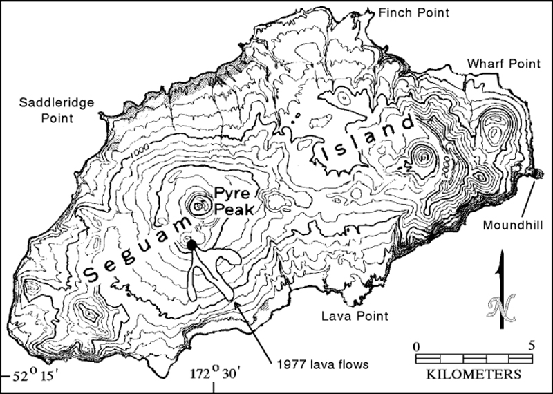 |
Figure 1. Topographic map of Seguam Island showing the area of December 1992 activity (dot S of Pyre Peak). The line SE from the vent site represents the 1977 lava fountains, and the outline shows the 1977 lava flows. Courtesy of AVO. |
Information Contacts: Michael Doukas, USGS Anchorage.
Ash eruptions reported
A small ash burst, rising through clouds near Pyre Peak, was reported by the U.S. Coast Guard on 28 May. A plume to 3 km altitude was reported on 2 June by the NWS, but it is not known if the plume contained ash.
Information Contacts: AVO.
Ash eruptions to 2,400 m height; lava flow
Heavy ash eruptions rising 900-1,200 m were reported the morning of 31 July by the U.S. Coast Guard. A lava flow was also noted. According to these observers, the volcano was still erupting sporadically on 10 August, with light- to dark-gray ash plumes rising 2,400 m above the summit. Reports from Atka Island (~110 km W) indicate that weather conditions have frequently prevented observations.
Information Contacts: AVO.
Ash eruption to 2,500 m altitude
On 19 August, U.S. Coast Guard observers reported that Pyre Peak . . . was continuing to erupt from a vent ~180 m below the summit. A dark ash plume over the volcano that day reached an altitude of 2,500 m and drifted ESE. No reports of ashfall in the sparsely populated region were received. U.S. Coast Guard observers reported that Pyre Peak was continuing to erupt in late August, but poor weather conditions prevented observers from confirming continued activity through 3 September. Frequent poor weather and limited air traffic combine to make tracking of activity at this remote island volcano difficult.
Information Contacts: AVO.
|
|
||||||||||||||||||||||||||||
There is data available for 11 confirmed eruptive periods.
1993 May 28 - 1993 Aug 31 (on or after) Confirmed Eruption (Explosive / Effusive) VEI: 2
| Episode 1 | Eruption (Explosive / Effusive) | Near Pyre Peak | ||||||||||||||||||||||||||||
|---|---|---|---|---|---|---|---|---|---|---|---|---|---|---|---|---|---|---|---|---|---|---|---|---|---|---|---|---|---|
| 1993 May 28 - 1993 Aug 31 (on or after) | Evidence from Observations: Reported | ||||||||||||||||||||||||||||
|
List of 4 Events for Episode 1 at Near Pyre Peak
|
|||||||||||||||||||||||||||||
1992 Dec 27 - 1992 Dec 30 Confirmed Eruption (Explosive / Effusive) VEI: 2
| Episode 1 | Eruption (Explosive / Effusive) | Pyre Peak (1.5 km south of summit) | |||||||||||||||||||||||
|---|---|---|---|---|---|---|---|---|---|---|---|---|---|---|---|---|---|---|---|---|---|---|---|---|
| 1992 Dec 27 - 1992 Dec 30 | Evidence from Observations: Reported | |||||||||||||||||||||||
|
List of 3 Events for Episode 1 at Pyre Peak (1.5 km south of summit)
|
||||||||||||||||||||||||
1977 Mar 6 - 1977 Mar 8 (?) Confirmed Eruption (Explosive / Effusive) VEI: 1
| Episode 1 | Eruption (Explosive / Effusive) | Pyre Peak (2.5 km SE of summit) | |||||||||||||||||||||||||||||||||
|---|---|---|---|---|---|---|---|---|---|---|---|---|---|---|---|---|---|---|---|---|---|---|---|---|---|---|---|---|---|---|---|---|---|---|
| 1977 Mar 6 - 1977 Mar 8 (?) | Evidence from Observations: Reported | |||||||||||||||||||||||||||||||||
|
List of 5 Events for Episode 1 at Pyre Peak (2.5 km SE of summit)
|
||||||||||||||||||||||||||||||||||
[ 1927 ] Uncertain Eruption
| Episode 1 | Eruption (Explosive / Effusive) | ||||||||||||||
|---|---|---|---|---|---|---|---|---|---|---|---|---|---|---|
| 1927 - Unknown | Evidence from Unknown | |||||||||||||
|
List of 1 Events for Episode 1
|
||||||||||||||
1902 Confirmed Eruption (Explosive / Effusive) VEI: 3
| Episode 1 | Eruption (Explosive / Effusive) | |||||||||||||||||||
|---|---|---|---|---|---|---|---|---|---|---|---|---|---|---|---|---|---|---|---|
| 1902 - Unknown | Evidence from Observations: Reported | ||||||||||||||||||
|
List of 2 Events for Episode 1
|
|||||||||||||||||||
1892 Apr 15 ± 45 days Confirmed Eruption (Explosive / Effusive) VEI: 3
| Episode 1 | Eruption (Explosive / Effusive) | |||||||||||||||||||||||||||||
|---|---|---|---|---|---|---|---|---|---|---|---|---|---|---|---|---|---|---|---|---|---|---|---|---|---|---|---|---|---|
| 1892 Apr 15 ± 45 days - Unknown | Evidence from Observations: Reported | ||||||||||||||||||||||||||||
|
List of 4 Events for Episode 1
|
|||||||||||||||||||||||||||||
1891 Dec Confirmed Eruption (Explosive / Effusive) VEI: 2
| Episode 1 | Eruption (Explosive / Effusive) | |||||||||||||||||||
|---|---|---|---|---|---|---|---|---|---|---|---|---|---|---|---|---|---|---|---|
| 1891 Dec - Unknown | Evidence from Observations: Reported | ||||||||||||||||||
|
List of 2 Events for Episode 1
|
|||||||||||||||||||
[ 1827 ] Uncertain Eruption
| Episode 1 | Eruption (Explosive / Effusive) | ||||||||||||||
|---|---|---|---|---|---|---|---|---|---|---|---|---|---|---|
| 1827 - Unknown | Evidence from Unknown | |||||||||||||
|
List of 1 Events for Episode 1
|
||||||||||||||
1786 - 1790 Confirmed Eruption (Explosive / Effusive)
| Episode 1 | Eruption (Explosive / Effusive) | ||||
|---|---|---|---|---|
| 1786 - 1790 | Evidence from Observations: Reported | |||
0250 ± 500 years Confirmed Eruption (Explosive / Effusive)
| Episode 1 | Eruption (Explosive / Effusive) | West of Wilcox volcano | |||||||||||||
|---|---|---|---|---|---|---|---|---|---|---|---|---|---|---|
| 0250 ± 500 years - Unknown | Evidence from Isotopic: Uranium-series | |||||||||||||
|
List of 1 Events for Episode 1 at West of Wilcox volcano
|
||||||||||||||
4050 BCE ± 4000 years Confirmed Eruption (Explosive / Effusive) VEI: 0
| Episode 1 | Eruption (Explosive / Effusive) | W flank of cone in eastern caldera | ||||||||||||||||||
|---|---|---|---|---|---|---|---|---|---|---|---|---|---|---|---|---|---|---|---|
| 4050 BCE ± 4000 years - Unknown | Evidence from Isotopic: Uranium-series | ||||||||||||||||||
|
List of 2 Events for Episode 1 at W flank of cone in eastern caldera
|
|||||||||||||||||||
5100 BCE ± 2000 years Confirmed Eruption (Explosive / Effusive) VEI: 0
| Episode 1 | Eruption (Explosive / Effusive) | W flank of cone in eastern caldera | ||||||||||||||||||
|---|---|---|---|---|---|---|---|---|---|---|---|---|---|---|---|---|---|---|---|
| 5100 BCE ± 2000 years - Unknown | Evidence from Isotopic: Uranium-series | ||||||||||||||||||
|
List of 2 Events for Episode 1 at W flank of cone in eastern caldera
|
|||||||||||||||||||
7300 BCE ± 2250 years Confirmed Eruption (Explosive / Effusive) VEI: 5 (?)
| Episode 1 | Eruption (Explosive / Effusive) | Wilcox volcano | ||||||||||||||||||||||||||||
|---|---|---|---|---|---|---|---|---|---|---|---|---|---|---|---|---|---|---|---|---|---|---|---|---|---|---|---|---|---|
| 7300 BCE ± 2250 years - Unknown | Evidence from Isotopic: Ar/Ar | ||||||||||||||||||||||||||||
|
List of 4 Events for Episode 1 at Wilcox volcano
|
|||||||||||||||||||||||||||||
This compilation of synonyms and subsidiary features may not be comprehensive. Features are organized into four major categories: Cones, Craters, Domes, and Thermal Features. Synonyms of features appear indented below the primary name. In some cases additional feature type, elevation, or location details are provided.
Synonyms |
||||
| Siguam | Goreli | Giguan | ||||
Cones |
||||
| Feature Name | Feature Type | Elevation | Latitude | Longitude |
| Moundhill | Lava cone | 587 m | 52° 21' 0.00" N | 172° 19' 0.00" W |
| Pyre Peak | Pyroclastic cone | 1054 m | 52° 19' 0.00" N | 172° 31' 0.00" W |
| Wilcox | Stratovolcano | 52° 19' 30.00" N | 172° 21' 0.00" W | |
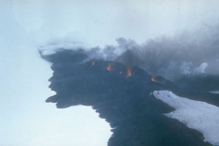 Lava fountains rise above a fissure on Seguam volcano on 8 March 1977. This view from the south shows part of the 1.5-km-long eruptive fissure SE of Pyre Peak. Black lava flows move across the snow from the fissure and diverge around an older cone to the lower right. Pyre Peak, within the westernmost of two calderas, is surrounded by fresh lava fields.
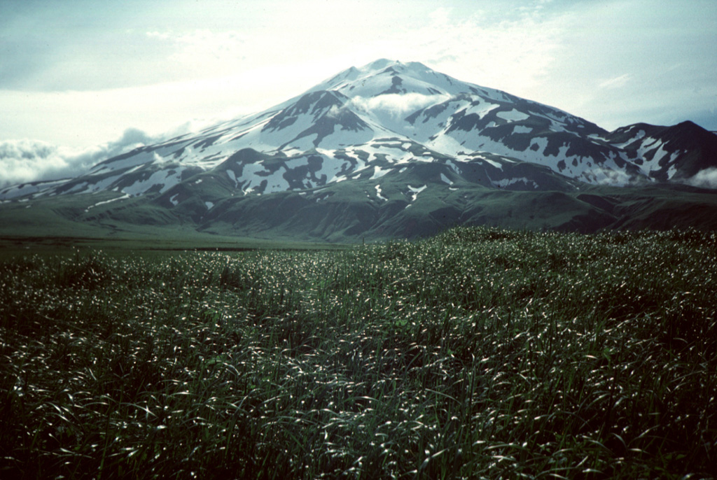
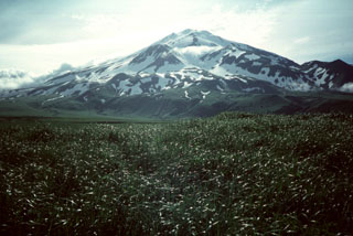 Pyre Peak was constructed within a 3-km-wide caldera and is seen from near the western tip of Seguam Island. The 11.5 x 24 km island contains two calderas, each with a Holocene cone. A third Holocene cone is at the eastern end of the island. The cone rises 1 km above the caldera floor and has been the source of many of the historical eruptions.
There are no samples for Seguam in the Smithsonian's NMNH Department of Mineral Sciences Rock and Ore collection.
| Alaska Volcano Observatory (Link to Seguam) | The Alaska Volcano Observatory (AVO) is a joint program of the U.S. Geological Survey (USGS), the Geophysical Institute of the University of Alaska Fairbanks (UAFGI), and the State of Alaska Division of Geological and Geophysical Surveys (ADGGS). AVO was formed in 1988, and uses federal, state, and university resources to monitor and study Alaska's hazardous volcanoes, to predict and record eruptive activity, and to mitigate volcanic hazards to life and property. |
| Copernicus Browser | The Copernicus Browser replaced the Sentinel Hub Playground browser in 2023, to provide access to Earth observation archives from the Copernicus Data Space Ecosystem, the main distribution platform for data from the EU Copernicus missions. |
| MIROVA | Middle InfraRed Observation of Volcanic Activity (MIROVA) is a near real time volcanic hot-spot detection system based on the analysis of MODIS (Moderate Resolution Imaging Spectroradiometer) data. In particular, MIROVA uses the Middle InfraRed Radiation (MIR), measured over target volcanoes, in order to detect, locate and measure the heat radiation sourced from volcanic activity. |
| MODVOLC Thermal Alerts | Using infrared satellite Moderate Resolution Imaging Spectroradiometer (MODIS) data, scientists at the Hawai'i Institute of Geophysics and Planetology, University of Hawai'i, developed an automated system called MODVOLC to map thermal hot-spots in near real time. For each MODIS image, the algorithm automatically scans each 1 km pixel within it to check for high-temperature hot-spots. When one is found the date, time, location, and intensity are recorded. MODIS looks at every square km of the Earth every 48 hours, once during the day and once during the night, and the presence of two MODIS sensors in space allows at least four hot-spot observations every two days. Each day updated global maps are compiled to display the locations of all hot spots detected in the previous 24 hours. There is a drop-down list with volcano names which allow users to 'zoom-in' and examine the distribution of hot-spots at a variety of spatial scales. |
|
WOVOdat
Single Volcano View Temporal Evolution of Unrest Side by Side Volcanoes |
WOVOdat is a database of volcanic unrest; instrumentally and visually recorded changes in seismicity, ground deformation, gas emission, and other parameters from their normal baselines. It is sponsored by the World Organization of Volcano Observatories (WOVO) and presently hosted at the Earth Observatory of Singapore.
GVMID Data on Volcano Monitoring Infrastructure The Global Volcano Monitoring Infrastructure Database GVMID, is aimed at documenting and improving capabilities of volcano monitoring from the ground and space. GVMID should provide a snapshot and baseline view of the techniques and instrumentation that are in place at various volcanoes, which can be use by volcano observatories as reference to setup new monitoring system or improving networks at a specific volcano. These data will allow identification of what monitoring gaps exist, which can be then targeted by remote sensing infrastructure and future instrument deployments. |
| Volcanic Hazard Maps | The IAVCEI Commission on Volcanic Hazards and Risk has a Volcanic Hazard Maps database designed to serve as a resource for hazard mappers (or other interested parties) to explore how common issues in hazard map development have been addressed at different volcanoes, in different countries, for different hazards, and for different intended audiences. In addition to the comprehensive, searchable Volcanic Hazard Maps Database, this website contains information about diversity of volcanic hazard maps, illustrated using examples from the database. This site is for educational purposes related to volcanic hazard maps. Hazard maps found on this website should not be used for emergency purposes. For the most recent, official hazard map for a particular volcano, please seek out the proper institutional authorities on the matter. |
| IRIS seismic stations/networks | Incorporated Research Institutions for Seismology (IRIS) Data Services map showing the location of seismic stations from all available networks (permanent or temporary) within a radius of 0.18° (about 20 km at mid-latitudes) from the given location of Seguam. Users can customize a variety of filters and options in the left panel. Note that if there are no stations are known the map will default to show the entire world with a "No data matched request" error notice. |
| UNAVCO GPS/GNSS stations | Geodetic Data Services map from UNAVCO showing the location of GPS/GNSS stations from all available networks (permanent or temporary) within a radius of 20 km from the given location of Seguam. Users can customize the data search based on station or network names, location, and time window. Requires Adobe Flash Player. |
| DECADE Data | The DECADE portal, still in the developmental stage, serves as an example of the proposed interoperability between The Smithsonian Institution's Global Volcanism Program, the Mapping Gas Emissions (MaGa) Database, and the EarthChem Geochemical Portal. The Deep Earth Carbon Degassing (DECADE) initiative seeks to use new and established technologies to determine accurate global fluxes of volcanic CO2 to the atmosphere, but installing CO2 monitoring networks on 20 of the world's 150 most actively degassing volcanoes. The group uses related laboratory-based studies (direct gas sampling and analysis, melt inclusions) to provide new data for direct degassing of deep earth carbon to the atmosphere. |
| Large Eruptions of Seguam | Information about large Quaternary eruptions (VEI >= 4) is cataloged in the Large Magnitude Explosive Volcanic Eruptions (LaMEVE) database of the Volcano Global Risk Identification and Analysis Project (VOGRIPA). |
| EarthChem | EarthChem develops and maintains databases, software, and services that support the preservation, discovery, access and analysis of geochemical data, and facilitate their integration with the broad array of other available earth science parameters. EarthChem is operated by a joint team of disciplinary scientists, data scientists, data managers and information technology developers who are part of the NSF-funded data facility Integrated Earth Data Applications (IEDA). IEDA is a collaborative effort of EarthChem and the Marine Geoscience Data System (MGDS). |