

On 13 October AVO changed both the Aviation Color Code and the Volcano Alert Level for Wrangell to Unassigned because of a station outage and the inability to reliably detect unrest at the volcano. AVO will continue using satellite, regional infrasound, and lightning data, and reports from pilots and ground observers to detect signs of eruptive activity.
Source: US Geological Survey Alaska Volcano Observatory (AVO)
Occasional steam plumes and wind-blown ash, but no recent eruptive activity
A previous report on Wrangell noted that the heat flux from a crater on the N side of the summit rim had increased by an order of magnitude between 1964 and 1986 (SEAN 11:04). Wrangell has several active fumarolic areas in its summit caldera. These fumaroles frequently produce steam plumes that are mistaken for eruptive activity. The Alaska Volcano Observatory (AVO) receives several reports per year from pilots and local residents who observe larger than normal steam clouds over the summit. Although there have been some events possibly involving wind-blown ash, there have been no recent confirmed eruptions.
Activity during 1996-2000. According to Neal and McGimsey (1997), a pilot reported a suspicious cloud around 18 January 1996 rising about 1.5 km near Wrangell. The National Weather Service (NWS) confirmed that a robust steam plume had been visible over the volcano for several weeks.
McGimsey and Wallace (1999) reported that, on 3 June 1997, a pilot reported steam rising from the summit. On 24 June another report described a steam plume rising about 200 m above the summit. This sighting was not observed on satellite imagery.
McGimsey and others (2004) reported that on the morning of 14 May 1999, a NWS observer in Gulkana (about 75 km WNW) reported anomalous steam emissions containing a small amount of ash. During clear weather at approximately 0930 local time, a rapidly billowing grayish-white plume rose to about 900 m above the N summit crater. The observer stated that at this time of year, on clear days, a small, wispy, steam plume is usually visible above Wrangell in the early morning, and dissipates by early afternoon. On this day, the plume developed quickly, was abnormally voluminous, and had a grayish color.
A pilot had also observed the activity and noticed that more "dirt" surrounded the N crater than usual, and that on the upper part of the Chestnina Glacier high on the SW flank, blocks of ice were chaotically jumbled (higher relief between blocks) and that the glacier surface was much more crevassed than he had ever previously seen. He also observed that one of two known fumaroles at 3,350 m elevation on the S flank, which typically issue steam through ice holes, was surrounded by a sizeable patch of bare rock, a new development since his last recent flight over the area. The pilot further reported that he had observed no sign of flowage or melting events high on the flank, but that he had not flown over the lower reaches of the glacier. As of 1700 that day the NWS observer in Gulkana could still see a small steam plume and with binoculars could see that the snow around the summit area appeared to be light gray and that this was a definite color contrast and not an effect from shadows.
According to Neal and others (2004), a Trans Alaska Pipeline worker reported an unusually strong, white steam plume on 18 March 2000 between 0500 and 0600 local time. Later that day a National Park Service (NPS) employee in Kenny Lake reported robust steaming during the previous month from multiple sources on the SW flank between approximately 600-1,500 m below the summit. AVO found no anomalies in satellite imagery and concluded that no significant unrest had occurred.
Activity during 2002-2003. Neal and others (2005) reported that on 1 August 2002, AVO received several calls reporting a dark cloud drifting downwind from the general summit area and a dark deposit high on its snow-covered flank. AVO seismologists, however, checked data from the Wrangell seismic network and, based on a lack of correlative seismicity, concluded that no eruption or explosion had occurred. AVO also consulted with a local NPS geologist, who suggested that high winds had lofted fine-grained material exposed in the area near the summit fumaroles. On 4 August, an AVO geologist traveling in the area verified that a diffuse, light gray stripe extended a short distance down the flank of the volcano, emanating from the W caldera rim.
Subsequently, a local resident presented AVO with a video showing the waning portion of the event and his written observations. The witness described multiple dark billowing black ash puffs; the wind was from the E and the puffs were not rising over the summit. By the time he had returned to a good vantage point to film, about 10-12 minutes later, the billowing had stopped and the puffs had "turned a more grayish color."
According to the authors, the video showed discrete, light gray "puffs" that moved downwind and retained their individual integrity. There were no other weather clouds in the vicinity. A light gray, relatively motionless and irregular-shaped cloud sat near the caldera rim. A breeze could be observed at ground level (indicated by motion in the trees) but at altitude, clouds were not shearing rapidly. High on the snow-covered flank, a gray-colored swath extended from a high point at the W caldera rim near Wrangell's crater. The end of the video footage showed two distinct dark areas on the rim that were normally snow-covered. The resident's son reported a similar but more vigorous event on 2 August at about the same time of the day, but AVO received no further inquiries or reports.
AVO concluded that no volcanic process of significance had occurred. However, the authors stated "these observations remain enigmatic: lack of any seismicity would seem to preclude a phreatic or magmatic eruption and yet the pulsatory, 'puffing' nature of the dirty clouds is difficult to reconcile with a wind phenomenon."
McGimsey and others (2005) reported that NPS geologist Danny Rosenkrans contacted AVO with photographs taken by a local resident on 11 June 2003 showing an unusual towering cloud over the summit. Although the authors acknowledged that it could simply have been a common cumulus cloud, they noted that the absence of cumulus clouds in the area over nearby Mts. Drum and Sanford suggested that calm weather conditions permitted steam emissions from the known summit fumaroles to coalesce and form the plume-like cloud.
McGimsey and others (2005) also reported that on 18 September 2003 the Center Weather Service Unit called with a Pilot Weather Report of a steam plume 600-700 m over the volcano. The pilot reported no ash or sulfur smell. AVO scientists checked satellite imagery and seismograms and found nothing unusual.
Activity during 2007. McGimsey and others (2011) stated that an M 8.2 earthquake in the Kurile Islands on 13 January 2007 may have triggered seismicity at Wrangell and other nearby volcanoes. There were no reports of steaming immediately following this event; however, two weeks later, on 7 February, a relatively large local earthquake was recorded on the Wrangell network that was followed another two weeks later by steaming from the summit. According to the authors, this was the first report of Wrangell steaming in several years.
The authors also mentioned additional episodes of steaming in March 2007. On 25 March, a resident living about 80 km N of the summit reported a strong sulfur odor, an occurrence the resident stated was rare in his 15 years of living in the area. Earlier that day, the Wrangell network had recorded several multi-station seismic events. The authors note that several months later, local residents sent AVO photographs taken on 20 June of steaming from Wrangell and a deposit of ash extending from the W crater many hundreds of meters down the SW flank (figure 2). According to the authors, this ash was likely redistributed from the summit craters by strong winds. No anomalous seismic activity was observed.
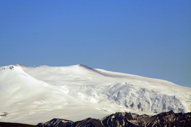 |
Figure 2. View of the northwest flank of Wrangell volcano on 20 Jun e2007 showing a dark stripe of probable redistributed ash extending from West Crater. The photo was taken at Mile 20 of the Tok Cutoff (Hwy 1), between Gakona and Slana. Strong north winds were reported. Note the steam plume rising from skyline saddle near North Crater (left). Photo by Norma Traw, courtesy of AVO. |
Activity during 2010. A report by Neal and others (2014) noted that no significant eruptive activity or restlessness had occurred in 2010. However, the authors stated that AVO had received a report of possible vapor emission from the summit area. In May 2010, a single LIDAR swath taken during a summit overflight by glaciologists from the Geophysical Institute, University of Alaska-Fairbanks, depicted the topography of North Crater, a long-known fumarolic source on the NW rim of the ice-filled summit caldera. According to the authors, there are several secondary depressions, including a complex, kidney-bean shaped pit about 20 m deep and 200 m across, located in the center of North crater. This result is broadly consistent with previously recorded surveys of North Crater using photogrammetric techniques.
Neal and others (2014) reported that in early November 2010, a long-time local resident called AVO to report "more activity at the Mount Wrangell summit than he had ever seen before." He sent AVO several images of the volcano taken on 2 November and assured AVO that when the activity in question began, there had been no weather clouds in the area. He noted about ten "bursts" from the summit and said this was unusual compared to the typical steady emissions often seen. The authors stated that AVO reviewed available seismic and satellite data and, finding no evidence of volcanic signals, concluded that the phenomenon was most likely weather-related.
Activity during 2012. According to Herrick and others (2014), no eruptive activity or significant unrest had occurred in 2012, but as in previous years AVO received reports of fumarolic activity high on its flanks. The authors noted that, because of seismic station outages, AVO had removed Wrangell from its monitored list on 27 January 2012, where it remained for at least through the rest of the year. At the same time, the Aviation Color Code and Volcano Alert Level were downgraded from Green/Normal to Unassigned.
Herrick and others (2014) reported that on 11 March 2012, local observers noted "puffs of steam." AVO analysts using satellite images detected small plumes above known fumaroles. On 20 March 2012, a citizen noticed unusually rigorous steaming and described it as looking like "a pressure cooker shot through with nails." Steam rose from both the summit and a location on the SW flank at an elevation of about 3 km. Other calls to AVO registered concern about the significant plumes. Because no other evidence of significant volcanic unrest was detected, AVO concluded these events were likely generated by normal fumarolic activity.
References. Neal, C., and McGimsey, R. G., 1997, 1996 volcanic activity in Alaska and Kamchatka: Summary of events and response of the Alaska Volcano Observatory: U.S. Geological Survey Open-File Report OF 97-0433, 34 p.
McGimsey, R. G., and Wallace, K. L., 1999, 1997 volcanic activity in Alaska and Kamchatka: Summary of events and response of the Alaska Volcano Observatory: U.S. Geological Survey Open-File Report OF 99-0448, 42 p.
McGimsey, R. G., Neal, C. A., and Girina, O., 2004, 1999 Volcanic activity in Alaska and Kamchatka: Summary of events and response of the Alaska Volcano Observatory: U.S. Geological Survey Open-File Report OF 2004-1033, 49 p.
McGimsey, R. G., Neal, C. A., Dixon, J. P., Malik, N., and Chibisova, M., 2011, 2007 Volcanic activity in Alaska, Kamchatka, and the Kurile Islands: Summary of events and response of the Alaska Volcano Observatory: U.S. Geological Survey Scientific Investigations Report 2010-5242, 110 p. Available online at http://pubs.usgs.gov/sir/2010/5242/.
Neal, C. A., McGimsey, R. G., and Chubarova, O., 2004, 2000 Volcanic activity in Alaska and Kamchatka: Summary of events and response of the Alaska Volcano Observatory: U.S. Geological Survey Open-File Report OF 2004-1034, 37 p.
Neal, C. A., McGimsey, R. G., and Girina, O., 2005, 2002 Volcanic activity in Alaska and Kamchatka: Summary of events and response of the Alaska Volcano Observatory: U.S. Geological Survey Open-File Report OF 2004-1058, 55 p., available online at http://pubs.usgs.gov/of/2004/1058/.
McGimsey, R. G., Neal, C. A., and Girina, O., 2005, 2003 volcanic activity in Alaska and Kamchatka: Summary of events and response of the Alaska Volcano Observatory: U.S. Geological Survey Open-File Report 2005-1310, 62 p., http://pubs.usgs.gov/of/2005/1310/.
McGimsey, R. G., Neal, C. A., Dixon, J. P., Malik, N., and Chibisova, M., 2011, 2007 Volcanic activity in Alaska, Kamchatka, and the Kurile Islands: Summary of events and response of the Alaska Volcano Observatory: U.S. Geological Survey Scientific Investigations Report 2010-5242, 110 p. Available online at http://pubs.usgs.gov/sir/2010/5242/.
Neal, C. A., Herrick, J., Girina, O. A., Chibisova, M., Rybin, A., McGimsey, R. G., and Dixon, J., 2014, 2010 Volcanic activity in Alaska, Kamchatka, and the Kurile Islands - Summary of events and response of the Alaska Volcano Observatory: U.S. Geological Survey Scientific Investigations Report 2014-5034, 76 p., http://dx.doi.org/10.3133/sir20145034/.
Herrick, J. A., Neal, C. A., Cameron, C. E., Dixon, J. P., and McGimsey, R. G., 2014, 2012 Volcanic activity in Alaska: Summary of events and response of the Alaska Volcano Observatory: U.S. Geological Survey Scientific Investigations Report 2014-5160, 82p., http://dx.doi.org/10.3133/sir20145160/.
Information Contacts: Alaska Volcano Observatory (AVO), a cooperative program of a) U.S. Geological Survey, 4200 University Drive, Anchorage, AK 99508-4667 USA (URL: https://avo.alaska.edu/), b) Geophysical Institute, University of Alaska, PO Box 757320, Fairbanks, AK 99775-7320, USA, and c) Alaska Division of Geological & Geophysical Surveys, 794 University Ave., Suite 200, Fairbanks, AK 99709, USA (URL: http://dggs.alaska.gov/).
2023: October
On 13 October AVO changed both the Aviation Color Code and the Volcano Alert Level for Wrangell to Unassigned because of a station outage and the inability to reliably detect unrest at the volcano. AVO will continue using satellite, regional infrasound, and lightning data, and reports from pilots and ground observers to detect signs of eruptive activity.
Source: US Geological Survey Alaska Volcano Observatory (AVO)
Reports are organized chronologically and indexed below by Month/Year (Publication Volume:Number), and include a one-line summary. Click on the index link or scroll down to read the reports.
Twenty years of increased heat flow; crater ice melts; fumarole temperatures increase; larger plumes
University of Alaska geologists have documented a major long-term increase in heat flux at Mt. Wrangell, an andesitic shield volcano with a summit caldera 6 km long, 4 km wide, and 1 km deep. Heat flux from a crater on the N side of the summit caldera rim has increased by an order of magnitude since the great earthquake of 1964 (magnitude 8.3) centered ~250 km to the SW. Annual aerial photogrammetric surveys and digital cross sections demonstrate that since 1965 about 85% of the 4.4 x 10⁷ m3 of ice in the north crater (figure 1) has melted; all melting at that altitude is caused by volcanic heat. Fumaroles remained at the boiling point (86°C at 600 mb pressure) from 1961 through the late 1970's, but some superheating may have begun by 1980, and in 1982 superheating was evident as vapor rose 1 m above the vents before condensing. In 1985, a temperature of l92°C was measured at the edge of one fumarole. The fumarole gases were dominantly water, but the SO2 content of the dry fraction was 28% in 1982 and 35% in 1985; most of the remaining gas was CO2 (gases were collected by Roman Motyka and Matthew Sturm, 1982, Matthew Sturm and Daniel Solie, 1985; analyses by W. Evans, USGS, and Roman Motyka).
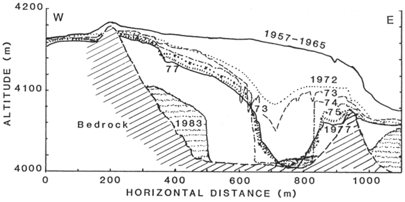 |
Figure 1. E-W cross-section of Wrangell's N crater, showing changes in the ice volume of the crater between 1957 and 1983; after Benson and Motyka (1978) and Benson and others (1984). |
During April 1986, nearby residents reported occasional plumes rising as much as 1 km above the summit, with several observations of large plumes the last week of the month. On 30 April, the plume was estimated to be 1 km high and 300 m wide. Geologists plan overflights to monitor the activity.
References. Benson, C., and Follett, A., 1986, Application of photogrammetry to the study of volcano-glacier interactions on Mt. Wrangell, Alaska: Photogrammetric Engineering and Remote Sensing, v. 52, no. 6, p. 813-827.
Benson, C., and Motyka, R., 1978, Glacier-volcano interactions on Mt. Wrangell, Alaska: Annual Report, Geophysical Institute, University of Alaska, 1977-78, p. 1-25.
Benson, C., Sturm, M., and others, 1984, Glacier-volcano interactions, Mt. Wrangell, Alaska: Annual Report, Geophysical Institute, University of Alaska, 1983-84, p. 102-104.
Information Contacts: Carl S. Benson, Geophysical Institute, Univ of Alaska, Fairbanks; Roman Motyka, Alaska Dept of Natural Resources, Juneau.
Occasional steam plumes and wind-blown ash, but no recent eruptive activity
A previous report on Wrangell noted that the heat flux from a crater on the N side of the summit rim had increased by an order of magnitude between 1964 and 1986 (SEAN 11:04). Wrangell has several active fumarolic areas in its summit caldera. These fumaroles frequently produce steam plumes that are mistaken for eruptive activity. The Alaska Volcano Observatory (AVO) receives several reports per year from pilots and local residents who observe larger than normal steam clouds over the summit. Although there have been some events possibly involving wind-blown ash, there have been no recent confirmed eruptions.
Activity during 1996-2000. According to Neal and McGimsey (1997), a pilot reported a suspicious cloud around 18 January 1996 rising about 1.5 km near Wrangell. The National Weather Service (NWS) confirmed that a robust steam plume had been visible over the volcano for several weeks.
McGimsey and Wallace (1999) reported that, on 3 June 1997, a pilot reported steam rising from the summit. On 24 June another report described a steam plume rising about 200 m above the summit. This sighting was not observed on satellite imagery.
McGimsey and others (2004) reported that on the morning of 14 May 1999, a NWS observer in Gulkana (about 75 km WNW) reported anomalous steam emissions containing a small amount of ash. During clear weather at approximately 0930 local time, a rapidly billowing grayish-white plume rose to about 900 m above the N summit crater. The observer stated that at this time of year, on clear days, a small, wispy, steam plume is usually visible above Wrangell in the early morning, and dissipates by early afternoon. On this day, the plume developed quickly, was abnormally voluminous, and had a grayish color.
A pilot had also observed the activity and noticed that more "dirt" surrounded the N crater than usual, and that on the upper part of the Chestnina Glacier high on the SW flank, blocks of ice were chaotically jumbled (higher relief between blocks) and that the glacier surface was much more crevassed than he had ever previously seen. He also observed that one of two known fumaroles at 3,350 m elevation on the S flank, which typically issue steam through ice holes, was surrounded by a sizeable patch of bare rock, a new development since his last recent flight over the area. The pilot further reported that he had observed no sign of flowage or melting events high on the flank, but that he had not flown over the lower reaches of the glacier. As of 1700 that day the NWS observer in Gulkana could still see a small steam plume and with binoculars could see that the snow around the summit area appeared to be light gray and that this was a definite color contrast and not an effect from shadows.
According to Neal and others (2004), a Trans Alaska Pipeline worker reported an unusually strong, white steam plume on 18 March 2000 between 0500 and 0600 local time. Later that day a National Park Service (NPS) employee in Kenny Lake reported robust steaming during the previous month from multiple sources on the SW flank between approximately 600-1,500 m below the summit. AVO found no anomalies in satellite imagery and concluded that no significant unrest had occurred.
Activity during 2002-2003. Neal and others (2005) reported that on 1 August 2002, AVO received several calls reporting a dark cloud drifting downwind from the general summit area and a dark deposit high on its snow-covered flank. AVO seismologists, however, checked data from the Wrangell seismic network and, based on a lack of correlative seismicity, concluded that no eruption or explosion had occurred. AVO also consulted with a local NPS geologist, who suggested that high winds had lofted fine-grained material exposed in the area near the summit fumaroles. On 4 August, an AVO geologist traveling in the area verified that a diffuse, light gray stripe extended a short distance down the flank of the volcano, emanating from the W caldera rim.
Subsequently, a local resident presented AVO with a video showing the waning portion of the event and his written observations. The witness described multiple dark billowing black ash puffs; the wind was from the E and the puffs were not rising over the summit. By the time he had returned to a good vantage point to film, about 10-12 minutes later, the billowing had stopped and the puffs had "turned a more grayish color."
According to the authors, the video showed discrete, light gray "puffs" that moved downwind and retained their individual integrity. There were no other weather clouds in the vicinity. A light gray, relatively motionless and irregular-shaped cloud sat near the caldera rim. A breeze could be observed at ground level (indicated by motion in the trees) but at altitude, clouds were not shearing rapidly. High on the snow-covered flank, a gray-colored swath extended from a high point at the W caldera rim near Wrangell's crater. The end of the video footage showed two distinct dark areas on the rim that were normally snow-covered. The resident's son reported a similar but more vigorous event on 2 August at about the same time of the day, but AVO received no further inquiries or reports.
AVO concluded that no volcanic process of significance had occurred. However, the authors stated "these observations remain enigmatic: lack of any seismicity would seem to preclude a phreatic or magmatic eruption and yet the pulsatory, 'puffing' nature of the dirty clouds is difficult to reconcile with a wind phenomenon."
McGimsey and others (2005) reported that NPS geologist Danny Rosenkrans contacted AVO with photographs taken by a local resident on 11 June 2003 showing an unusual towering cloud over the summit. Although the authors acknowledged that it could simply have been a common cumulus cloud, they noted that the absence of cumulus clouds in the area over nearby Mts. Drum and Sanford suggested that calm weather conditions permitted steam emissions from the known summit fumaroles to coalesce and form the plume-like cloud.
McGimsey and others (2005) also reported that on 18 September 2003 the Center Weather Service Unit called with a Pilot Weather Report of a steam plume 600-700 m over the volcano. The pilot reported no ash or sulfur smell. AVO scientists checked satellite imagery and seismograms and found nothing unusual.
Activity during 2007. McGimsey and others (2011) stated that an M 8.2 earthquake in the Kurile Islands on 13 January 2007 may have triggered seismicity at Wrangell and other nearby volcanoes. There were no reports of steaming immediately following this event; however, two weeks later, on 7 February, a relatively large local earthquake was recorded on the Wrangell network that was followed another two weeks later by steaming from the summit. According to the authors, this was the first report of Wrangell steaming in several years.
The authors also mentioned additional episodes of steaming in March 2007. On 25 March, a resident living about 80 km N of the summit reported a strong sulfur odor, an occurrence the resident stated was rare in his 15 years of living in the area. Earlier that day, the Wrangell network had recorded several multi-station seismic events. The authors note that several months later, local residents sent AVO photographs taken on 20 June of steaming from Wrangell and a deposit of ash extending from the W crater many hundreds of meters down the SW flank (figure 2). According to the authors, this ash was likely redistributed from the summit craters by strong winds. No anomalous seismic activity was observed.
|
Figure 2. View of the northwest flank of Wrangell volcano on 20 Jun e2007 showing a dark stripe of probable redistributed ash extending from West Crater. The photo was taken at Mile 20 of the Tok Cutoff (Hwy 1), between Gakona and Slana. Strong north winds were reported. Note the steam plume rising from skyline saddle near North Crater (left). Photo by Norma Traw, courtesy of AVO. |
Activity during 2010. A report by Neal and others (2014) noted that no significant eruptive activity or restlessness had occurred in 2010. However, the authors stated that AVO had received a report of possible vapor emission from the summit area. In May 2010, a single LIDAR swath taken during a summit overflight by glaciologists from the Geophysical Institute, University of Alaska-Fairbanks, depicted the topography of North Crater, a long-known fumarolic source on the NW rim of the ice-filled summit caldera. According to the authors, there are several secondary depressions, including a complex, kidney-bean shaped pit about 20 m deep and 200 m across, located in the center of North crater. This result is broadly consistent with previously recorded surveys of North Crater using photogrammetric techniques.
Neal and others (2014) reported that in early November 2010, a long-time local resident called AVO to report "more activity at the Mount Wrangell summit than he had ever seen before." He sent AVO several images of the volcano taken on 2 November and assured AVO that when the activity in question began, there had been no weather clouds in the area. He noted about ten "bursts" from the summit and said this was unusual compared to the typical steady emissions often seen. The authors stated that AVO reviewed available seismic and satellite data and, finding no evidence of volcanic signals, concluded that the phenomenon was most likely weather-related.
Activity during 2012. According to Herrick and others (2014), no eruptive activity or significant unrest had occurred in 2012, but as in previous years AVO received reports of fumarolic activity high on its flanks. The authors noted that, because of seismic station outages, AVO had removed Wrangell from its monitored list on 27 January 2012, where it remained for at least through the rest of the year. At the same time, the Aviation Color Code and Volcano Alert Level were downgraded from Green/Normal to Unassigned.
Herrick and others (2014) reported that on 11 March 2012, local observers noted "puffs of steam." AVO analysts using satellite images detected small plumes above known fumaroles. On 20 March 2012, a citizen noticed unusually rigorous steaming and described it as looking like "a pressure cooker shot through with nails." Steam rose from both the summit and a location on the SW flank at an elevation of about 3 km. Other calls to AVO registered concern about the significant plumes. Because no other evidence of significant volcanic unrest was detected, AVO concluded these events were likely generated by normal fumarolic activity.
References. Neal, C., and McGimsey, R. G., 1997, 1996 volcanic activity in Alaska and Kamchatka: Summary of events and response of the Alaska Volcano Observatory: U.S. Geological Survey Open-File Report OF 97-0433, 34 p.
McGimsey, R. G., and Wallace, K. L., 1999, 1997 volcanic activity in Alaska and Kamchatka: Summary of events and response of the Alaska Volcano Observatory: U.S. Geological Survey Open-File Report OF 99-0448, 42 p.
McGimsey, R. G., Neal, C. A., and Girina, O., 2004, 1999 Volcanic activity in Alaska and Kamchatka: Summary of events and response of the Alaska Volcano Observatory: U.S. Geological Survey Open-File Report OF 2004-1033, 49 p.
McGimsey, R. G., Neal, C. A., Dixon, J. P., Malik, N., and Chibisova, M., 2011, 2007 Volcanic activity in Alaska, Kamchatka, and the Kurile Islands: Summary of events and response of the Alaska Volcano Observatory: U.S. Geological Survey Scientific Investigations Report 2010-5242, 110 p. Available online at http://pubs.usgs.gov/sir/2010/5242/.
Neal, C. A., McGimsey, R. G., and Chubarova, O., 2004, 2000 Volcanic activity in Alaska and Kamchatka: Summary of events and response of the Alaska Volcano Observatory: U.S. Geological Survey Open-File Report OF 2004-1034, 37 p.
Neal, C. A., McGimsey, R. G., and Girina, O., 2005, 2002 Volcanic activity in Alaska and Kamchatka: Summary of events and response of the Alaska Volcano Observatory: U.S. Geological Survey Open-File Report OF 2004-1058, 55 p., available online at http://pubs.usgs.gov/of/2004/1058/.
McGimsey, R. G., Neal, C. A., and Girina, O., 2005, 2003 volcanic activity in Alaska and Kamchatka: Summary of events and response of the Alaska Volcano Observatory: U.S. Geological Survey Open-File Report 2005-1310, 62 p., http://pubs.usgs.gov/of/2005/1310/.
McGimsey, R. G., Neal, C. A., Dixon, J. P., Malik, N., and Chibisova, M., 2011, 2007 Volcanic activity in Alaska, Kamchatka, and the Kurile Islands: Summary of events and response of the Alaska Volcano Observatory: U.S. Geological Survey Scientific Investigations Report 2010-5242, 110 p. Available online at http://pubs.usgs.gov/sir/2010/5242/.
Neal, C. A., Herrick, J., Girina, O. A., Chibisova, M., Rybin, A., McGimsey, R. G., and Dixon, J., 2014, 2010 Volcanic activity in Alaska, Kamchatka, and the Kurile Islands - Summary of events and response of the Alaska Volcano Observatory: U.S. Geological Survey Scientific Investigations Report 2014-5034, 76 p., http://dx.doi.org/10.3133/sir20145034/.
Herrick, J. A., Neal, C. A., Cameron, C. E., Dixon, J. P., and McGimsey, R. G., 2014, 2012 Volcanic activity in Alaska: Summary of events and response of the Alaska Volcano Observatory: U.S. Geological Survey Scientific Investigations Report 2014-5160, 82p., http://dx.doi.org/10.3133/sir20145160/.
Information Contacts: Alaska Volcano Observatory (AVO), a cooperative program of a) U.S. Geological Survey, 4200 University Drive, Anchorage, AK 99508-4667 USA (URL: https://avo.alaska.edu/), b) Geophysical Institute, University of Alaska, PO Box 757320, Fairbanks, AK 99775-7320, USA, and c) Alaska Division of Geological & Geophysical Surveys, 794 University Ave., Suite 200, Fairbanks, AK 99709, USA (URL: http://dggs.alaska.gov/).
|
|
||||||||||||||||||||||||||
There is data available for 5 confirmed eruptive periods.
[ 2002 Aug 1 - 2002 Aug 2 ] Uncertain Eruption
| Episode 1 | Uncertain | ||||||||||||||||||||||||
|---|---|---|---|---|---|---|---|---|---|---|---|---|---|---|---|---|---|---|---|---|---|---|---|---|
| 2002 Aug 1 - 2002 Aug 2 | Evidence from Observations: Reported | |||||||||||||||||||||||
|
List of 3 Events for Episode 1
|
||||||||||||||||||||||||
[ 1999 May 14 - 1999 May 14 ] Uncertain Eruption
| Episode 1 | Eruption (Explosive / Effusive) | ||||||||||||||||||||||||
|---|---|---|---|---|---|---|---|---|---|---|---|---|---|---|---|---|---|---|---|---|---|---|---|---|
| 1999 May 14 - 1999 May 14 | Evidence from Observations: Reported | |||||||||||||||||||||||
|
List of 3 Events for Episode 1
|
||||||||||||||||||||||||
[ 1969 Aug 16 ± 15 days ] Uncertain Eruption
| Episode 1 | Eruption (Explosive / Effusive) | West Crater | |||||||||||||||||||||||
|---|---|---|---|---|---|---|---|---|---|---|---|---|---|---|---|---|---|---|---|---|---|---|---|---|
| 1969 Aug 16 ± 15 days - Unknown | Evidence from Observations: Reported | |||||||||||||||||||||||
|
List of 3 Events for Episode 1 at West Crater
|
||||||||||||||||||||||||
[ 1930 Jun 30 ] Uncertain Eruption
| Episode 1 | Eruption (Explosive / Effusive) | |||||||||||||||||||
|---|---|---|---|---|---|---|---|---|---|---|---|---|---|---|---|---|---|---|---|
| 1930 Jun 30 - Unknown | Evidence from Unknown | ||||||||||||||||||
|
List of 2 Events for Episode 1
|
|||||||||||||||||||
[ 1921 Jul 3 - 1921 Jul 3 ] Uncertain Eruption
| Episode 1 | Eruption (Explosive / Effusive) | North flank? | ||||||||||||||||||
|---|---|---|---|---|---|---|---|---|---|---|---|---|---|---|---|---|---|---|---|
| 1921 Jul 3 - 1921 Jul 3 | Evidence from Unknown | ||||||||||||||||||
|
List of 2 Events for Episode 1 at North flank?
|
|||||||||||||||||||
1911 Apr 14 - 1912 Sep 14 (?) Confirmed Eruption (Explosive / Effusive) VEI: 1
| Episode 1 | Eruption (Explosive / Effusive) | |||||||||||||||||||||||||||||
|---|---|---|---|---|---|---|---|---|---|---|---|---|---|---|---|---|---|---|---|---|---|---|---|---|---|---|---|---|---|
| 1911 Apr 14 - 1912 Sep 14 (?) | Evidence from Observations: Reported | ||||||||||||||||||||||||||||
|
List of 4 Events for Episode 1
|
|||||||||||||||||||||||||||||
[ 1907 Apr 1 (on or before) ] Uncertain Eruption
| Episode 1 | Eruption (Explosive / Effusive) | |||||||||||||||||||
|---|---|---|---|---|---|---|---|---|---|---|---|---|---|---|---|---|---|---|---|
| 1907 Apr 1 (on or before) - Unknown | Evidence from Unknown | ||||||||||||||||||
|
List of 2 Events for Episode 1
|
|||||||||||||||||||
1902 Jul 15 ± 45 days Confirmed Eruption (Explosive / Effusive) VEI: 2
| Episode 1 | Eruption (Explosive / Effusive) | West Crater | |||||||||||||||||||||||
|---|---|---|---|---|---|---|---|---|---|---|---|---|---|---|---|---|---|---|---|---|---|---|---|---|
| 1902 Jul 15 ± 45 days - Unknown | Evidence from Observations: Reported | |||||||||||||||||||||||
|
List of 3 Events for Episode 1 at West Crater
|
||||||||||||||||||||||||
1900 Jun (on or before) Confirmed Eruption (Explosive / Effusive) VEI: 2 (?)
| Episode 1 | Eruption (Explosive / Effusive) | |||||||||||||||||||
|---|---|---|---|---|---|---|---|---|---|---|---|---|---|---|---|---|---|---|---|
| 1900 Jun (on or before) - Unknown | Evidence from Observations: Reported | ||||||||||||||||||
|
List of 2 Events for Episode 1
|
|||||||||||||||||||
1899 Sep 3 Confirmed Eruption (Explosive / Effusive) VEI: 2 (?)
| Episode 1 | Eruption (Explosive / Effusive) | ||||||||||||||||||||||||
|---|---|---|---|---|---|---|---|---|---|---|---|---|---|---|---|---|---|---|---|---|---|---|---|---|
| 1899 Sep 3 - Unknown | Evidence from Observations: Reported | |||||||||||||||||||||||
|
List of 3 Events for Episode 1
|
||||||||||||||||||||||||
[ 1884 Oct 26 - 1885 Feb 4 ] Uncertain Eruption
| Episode 1 | Eruption (Explosive / Effusive) | |||||||||||||||||||||||||||||
|---|---|---|---|---|---|---|---|---|---|---|---|---|---|---|---|---|---|---|---|---|---|---|---|---|---|---|---|---|---|
| 1884 Oct 26 - 1885 Feb 4 | Evidence from Unknown | ||||||||||||||||||||||||||||
|
List of 4 Events for Episode 1
|
|||||||||||||||||||||||||||||
[ 1819 ] Uncertain Eruption
| Episode 1 | Eruption (Explosive / Effusive) | ||||||||||||||||||||||||
|---|---|---|---|---|---|---|---|---|---|---|---|---|---|---|---|---|---|---|---|---|---|---|---|---|
| 1819 - Unknown | Evidence from Unknown | |||||||||||||||||||||||
|
List of 3 Events for Episode 1
|
||||||||||||||||||||||||
[ 1784 Jul ] Uncertain Eruption
| Episode 1 | Eruption (Explosive / Effusive) | |||||||||||||||||||
|---|---|---|---|---|---|---|---|---|---|---|---|---|---|---|---|---|---|---|---|
| 1784 Jul - Unknown | Evidence from Unknown | ||||||||||||||||||
|
List of 2 Events for Episode 1
|
|||||||||||||||||||
0190 ± 200 years Confirmed Eruption (Explosive / Effusive) VEI: 4
| Episode 1 | Eruption (Explosive / Effusive) | |||||||||||||||||||||||||||||
|---|---|---|---|---|---|---|---|---|---|---|---|---|---|---|---|---|---|---|---|---|---|---|---|---|---|---|---|---|---|
| 0190 ± 200 years - Unknown | Evidence from Isotopic: 14C (uncalibrated) | ||||||||||||||||||||||||||||
|
List of 4 Events for Episode 1
|
|||||||||||||||||||||||||||||
This compilation of synonyms and subsidiary features may not be comprehensive. Features are organized into four major categories: Cones, Craters, Domes, and Thermal Features. Synonyms of features appear indented below the primary name. In some cases additional feature type, elevation, or location details are provided.
Synonyms |
||||
| Chechitno Peak | Tillman, Mount | Uk'eledi | K'elt'aeni | ||||
Cones |
||||
| Feature Name | Feature Type | Elevation | Latitude | Longitude |
| Zanetti, Mount | Pyroclastic cone | 3965 m | 62° 2' 0.00" N | 144° 7' 0.00" W |
Craters |
||||
| Feature Name | Feature Type | Elevation | Latitude | Longitude |
| East Crater | Crater | |||
| North Crater | Crater | |||
| West Crater | Crater | |||
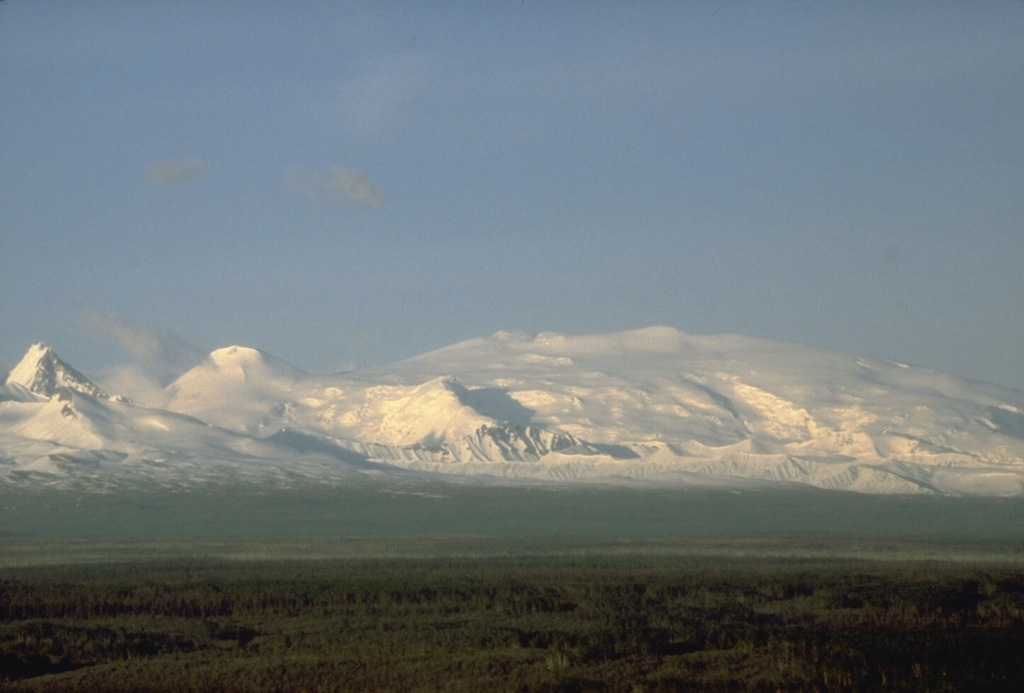
 This view, across the Copper River to the SE, shows Mount Sanford (left) and Mount Wrangell (right). The eroded Sanford shield volcano has a broad, rounded top that is surrounded by steep glacial cirques. Most of the volcano formed during the Pleistocene. Eruptive activity at Wrangell has continued into historical time.
 Mount Wrangell, on the right skyline, is part of the Wrangell volcanic field. There are two large calderas at the summit and the inner ice-filled caldera contains three craters. Minor, possibly phreatic eruptions have occurred during the 20th century. To the left is rounded Mount Zanetti, a flank cone. The sharp-topped peak to the far-left of this view from the SW is a flank cone of the neighboring Pleistocene Mount Drum.
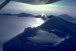 An aerial view shows a portion of the 4 x 6 km, ice-filled, summit caldera of Mount Wrangell. It is the part of the Wrangell volcanic field and has documented historical eruptions. Fumaroles (right-center) remain active at one of three scoria cones on the caldera rim.
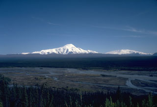
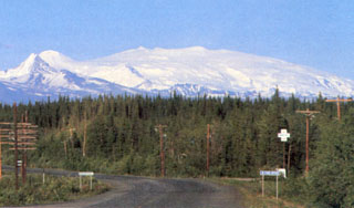 Alaska's Mount Wrangell is one of the most voluminous shield volcanoes in the world and is more than three times the volume of Rainier. It has a diameter of 30 km at 2,000 m elevation and a volume of about 900 km3. Eruption of unusually-low viscosity andesitic lavas at high eruption rates produced long lava flows that contributed to its low-angle morphology. The small snow-covered peak on the left is Mount Zanetti, a flank vent with about the same volume as St. Helens. Wrangell is seen here from Glennallen, 80 km to the west.
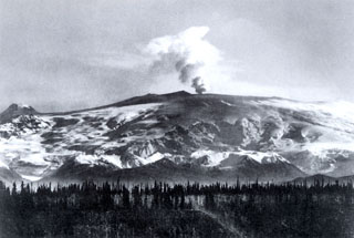 During a 1902 expedition in the Mount Wrangell area the U. S. Geological Survey scientist W.C. Mendenhall observed plumes and ash-covered snow. This photograph showing an ash plume rising above the summit crater was probably taken during the summer of 1902. Ash darkens the snow over a wide area of the southern flanks. The small cone on the far-left horizon is Mount Zanetti.
The following 4 samples associated with this volcano can be found in the Smithsonian's NMNH Department of Mineral Sciences collections, and may be availble for research (contact the Rock and Ore Collections Manager). Catalog number links will open a window with more information.
| Catalog Number | Sample Description | Lava Source | Collection Date |
|---|---|---|---|
| NMNH 117233-30 | Volcanic Ash | Chetaslina Ash Flow | -- |
| NMNH 117233-37 | Pumice | Chetaslina Ash Flow | -- |
| NMNH 117457-2 | Rhyolite | Capital Mt | -- |
| NMNH 117457-3 | Obsidian | -- | -- |
| Alaska Volcano Observatory (Link to Wrangell) | The Alaska Volcano Observatory (AVO) is a joint program of the U.S. Geological Survey (USGS), the Geophysical Institute of the University of Alaska Fairbanks (UAFGI), and the State of Alaska Division of Geological and Geophysical Surveys (ADGGS). AVO was formed in 1988, and uses federal, state, and university resources to monitor and study Alaska's hazardous volcanoes, to predict and record eruptive activity, and to mitigate volcanic hazards to life and property. |
| Copernicus Browser | The Copernicus Browser replaced the Sentinel Hub Playground browser in 2023, to provide access to Earth observation archives from the Copernicus Data Space Ecosystem, the main distribution platform for data from the EU Copernicus missions. |
| MIROVA | Middle InfraRed Observation of Volcanic Activity (MIROVA) is a near real time volcanic hot-spot detection system based on the analysis of MODIS (Moderate Resolution Imaging Spectroradiometer) data. In particular, MIROVA uses the Middle InfraRed Radiation (MIR), measured over target volcanoes, in order to detect, locate and measure the heat radiation sourced from volcanic activity. |
| MODVOLC Thermal Alerts | Using infrared satellite Moderate Resolution Imaging Spectroradiometer (MODIS) data, scientists at the Hawai'i Institute of Geophysics and Planetology, University of Hawai'i, developed an automated system called MODVOLC to map thermal hot-spots in near real time. For each MODIS image, the algorithm automatically scans each 1 km pixel within it to check for high-temperature hot-spots. When one is found the date, time, location, and intensity are recorded. MODIS looks at every square km of the Earth every 48 hours, once during the day and once during the night, and the presence of two MODIS sensors in space allows at least four hot-spot observations every two days. Each day updated global maps are compiled to display the locations of all hot spots detected in the previous 24 hours. There is a drop-down list with volcano names which allow users to 'zoom-in' and examine the distribution of hot-spots at a variety of spatial scales. |
|
WOVOdat
Single Volcano View Temporal Evolution of Unrest Side by Side Volcanoes |
WOVOdat is a database of volcanic unrest; instrumentally and visually recorded changes in seismicity, ground deformation, gas emission, and other parameters from their normal baselines. It is sponsored by the World Organization of Volcano Observatories (WOVO) and presently hosted at the Earth Observatory of Singapore.
GVMID Data on Volcano Monitoring Infrastructure The Global Volcano Monitoring Infrastructure Database GVMID, is aimed at documenting and improving capabilities of volcano monitoring from the ground and space. GVMID should provide a snapshot and baseline view of the techniques and instrumentation that are in place at various volcanoes, which can be use by volcano observatories as reference to setup new monitoring system or improving networks at a specific volcano. These data will allow identification of what monitoring gaps exist, which can be then targeted by remote sensing infrastructure and future instrument deployments. |
| Volcanic Hazard Maps | The IAVCEI Commission on Volcanic Hazards and Risk has a Volcanic Hazard Maps database designed to serve as a resource for hazard mappers (or other interested parties) to explore how common issues in hazard map development have been addressed at different volcanoes, in different countries, for different hazards, and for different intended audiences. In addition to the comprehensive, searchable Volcanic Hazard Maps Database, this website contains information about diversity of volcanic hazard maps, illustrated using examples from the database. This site is for educational purposes related to volcanic hazard maps. Hazard maps found on this website should not be used for emergency purposes. For the most recent, official hazard map for a particular volcano, please seek out the proper institutional authorities on the matter. |
| IRIS seismic stations/networks | Incorporated Research Institutions for Seismology (IRIS) Data Services map showing the location of seismic stations from all available networks (permanent or temporary) within a radius of 0.18° (about 20 km at mid-latitudes) from the given location of Wrangell. Users can customize a variety of filters and options in the left panel. Note that if there are no stations are known the map will default to show the entire world with a "No data matched request" error notice. |
| UNAVCO GPS/GNSS stations | Geodetic Data Services map from UNAVCO showing the location of GPS/GNSS stations from all available networks (permanent or temporary) within a radius of 20 km from the given location of Wrangell. Users can customize the data search based on station or network names, location, and time window. Requires Adobe Flash Player. |
| DECADE Data | The DECADE portal, still in the developmental stage, serves as an example of the proposed interoperability between The Smithsonian Institution's Global Volcanism Program, the Mapping Gas Emissions (MaGa) Database, and the EarthChem Geochemical Portal. The Deep Earth Carbon Degassing (DECADE) initiative seeks to use new and established technologies to determine accurate global fluxes of volcanic CO2 to the atmosphere, but installing CO2 monitoring networks on 20 of the world's 150 most actively degassing volcanoes. The group uses related laboratory-based studies (direct gas sampling and analysis, melt inclusions) to provide new data for direct degassing of deep earth carbon to the atmosphere. |
| Large Eruptions of Wrangell | Information about large Quaternary eruptions (VEI >= 4) is cataloged in the Large Magnitude Explosive Volcanic Eruptions (LaMEVE) database of the Volcano Global Risk Identification and Analysis Project (VOGRIPA). |
| EarthChem | EarthChem develops and maintains databases, software, and services that support the preservation, discovery, access and analysis of geochemical data, and facilitate their integration with the broad array of other available earth science parameters. EarthChem is operated by a joint team of disciplinary scientists, data scientists, data managers and information technology developers who are part of the NSF-funded data facility Integrated Earth Data Applications (IEDA). IEDA is a collaborative effort of EarthChem and the Marine Geoscience Data System (MGDS). |