
The Global Volcanism Program has no activity reports available for Mammoth Mountain.
The Global Volcanism Program has no Weekly Reports available for Mammoth Mountain.
The Global Volcanism Program has no Bulletin Reports available for Mammoth Mountain.
|
|
||||||||||||||||||||||||||||
There is data available for 2 confirmed eruptive periods.
1260 ± 40 years Confirmed Eruption (Explosive / Effusive)
| Episode 1 | Eruption (Explosive / Effusive) | North flank of Mammoth Mountain | ||||||||||||||||||
|---|---|---|---|---|---|---|---|---|---|---|---|---|---|---|---|---|---|---|---|
| 1260 ± 40 years - Unknown | Evidence from Isotopic: 14C (calibrated) | ||||||||||||||||||
|
List of 2 Events for Episode 1 at North flank of Mammoth Mountain
|
|||||||||||||||||||
6540 BCE ± 90 years Confirmed Eruption (Explosive / Effusive) VEI: 2
| Episode 1 | Eruption (Explosive / Effusive) | SSW of Mammoth Mtn (Red Cones) | ||||||||||||||||||||||||||||||||||||||
|---|---|---|---|---|---|---|---|---|---|---|---|---|---|---|---|---|---|---|---|---|---|---|---|---|---|---|---|---|---|---|---|---|---|---|---|---|---|---|---|
| 6540 BCE ± 90 years - Unknown | Evidence from Isotopic: 14C (uncalibrated) | ||||||||||||||||||||||||||||||||||||||
|
List of 6 Events for Episode 1 at SSW of Mammoth Mtn (Red Cones)
|
|||||||||||||||||||||||||||||||||||||||
This compilation of synonyms and subsidiary features may not be comprehensive. Features are organized into four major categories: Cones, Craters, Domes, and Thermal Features. Synonyms of features appear indented below the primary name. In some cases additional feature type, elevation, or location details are provided.
Cones |
||||
| Feature Name | Feature Type | Elevation | Latitude | Longitude |
| Red Cones | Pyroclastic cone | 2748 m | 37° 35' 0.00" N | 119° 3' 0.00" W |
Domes |
||||
| Feature Name | Feature Type | Elevation | Latitude | Longitude |
| Earthquake Dome | Dome | 2860 m | 37° 40' 0.00" N | 119° 0' 0.00" W |
| Mammoth Knolls | Dome | 2660 m | 37° 40' 0.00" N | 118° 59' 0.00" W |
 In 1995 soil gas fluctuations caused tree dieback at Horseshoe Lake on the SE side of Mammoth Mountain. A period of unrest including uplift and seismic swarms has continued for more than a decade.
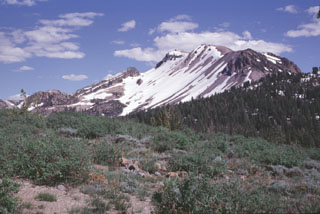 Mammoth Mountain rises to the SE of Minaret Summit. The 3369-m-high volcano formed between about 111,000 and 57,000 years ago and consists of a series of trachydacitic and rhyodacitic lava flows and lava domes. Magmatic activity at Mammoth Mountain overlapped the latest eruptions of the Long Valley caldera and ended prior to the onset of eruptions at the Mono-Inyo chain, although phreatic eruptions on the northern flank of Mammoth Mountain took place during the Holocene.
 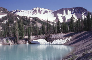 Water partially fills a phreatic crater formed on the northern flank of Mammoth Mountain, the snow-covered peak in the background. This and other nearby craters were formed by explosive eruptions about 700 years ago that were distinct from nearby eruptions at the southern end of the Inyo Craters. The Mammoth Mountain craters, some of which lie within the Mammoth Mountain ski area, are oriented NW-SE at the northern base of Mammoth Mountain.
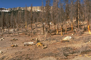
 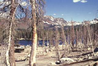 An area of extensive tree kill at Horseshoe Lake, SE of Mammoth Mountain, is seen in July 1998. Dead trees on the NW side of the lake contrast with undamaged trees on the opposite side of the lake. The Horseshoe Lake area is the largest of seven areas of elevated carbon dioxide concentrations located on the southern, northern, and western flanks of Mammoth Mountain. Trees began taking up of magmatic carbon dioxide in early 1990 following the 1989 Mammoth Mountain earthquake swarm.
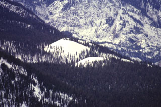 Red Cones, here mantled in winter white in a telephoto view looking SW from Mammoth Mountain, are two young basaltic cinder cones in the eastern Sierra Nevada Mountains near Devils Postpile National Monuement. The youthful-looking cones are Holocene in age.
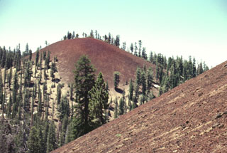 Red Cones, two closely spaced basaltic cinder cones SW of Mammoth Mountain, near Devils Postpile National Monument, are youthful unglaciated cones that were erupted about 8900 years ago. The two breached cones fed lava flows that joined to form a flow 2 km long and 2 km wide. The southern cone is seen here from the flanks of the northern cone. The reddish oxidized scoria of both cones is mantled by light-colored pumice erupted from the Inyo Craters about 650 years ago, visible here at the base of the northern cone.
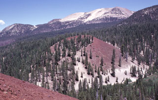 Mammoth Mountain, a Pleistocene trachydacitic lava-dome complex constructed on the SW topographic rim of the Long Valley caldera between about 200,000 and 50,000 years ago, forms the broad peak on the horizon. The Red Cones (center and lower left) are part of series of about three dozen mafic cones surrounding Mammoth Mountain. The oxidized reddish scoria of the cone, which was formed during the early Holocene, is mantled at its base by light-colored pumice erupted from the Inyo Craters about 650 years ago.
 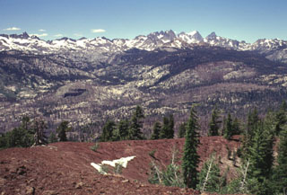 The rugged Sierra Nevada mountain range rises beyond the reddish rim of the southern cone of the twin Red Cones. The southern cone is breached to the NW and fed a lava flow that joined with one erupted from the SW breach of the northern cone to form a flow 2 km long and 2 km wide that traveled west to Crater Creek. Devils Postpile National Monument, with its spectacular columnar-jointed basaltic lava flow, lies along the Middle Fork of the San Joaquin River, below the rugged Minarets and Banner Peak on the horizon.
There are no samples for Mammoth Mountain in the Smithsonian's NMNH Department of Mineral Sciences Rock and Ore collection.
| Copernicus Browser | The Copernicus Browser replaced the Sentinel Hub Playground browser in 2023, to provide access to Earth observation archives from the Copernicus Data Space Ecosystem, the main distribution platform for data from the EU Copernicus missions. |
| MIROVA | Middle InfraRed Observation of Volcanic Activity (MIROVA) is a near real time volcanic hot-spot detection system based on the analysis of MODIS (Moderate Resolution Imaging Spectroradiometer) data. In particular, MIROVA uses the Middle InfraRed Radiation (MIR), measured over target volcanoes, in order to detect, locate and measure the heat radiation sourced from volcanic activity. |
| MODVOLC Thermal Alerts | Using infrared satellite Moderate Resolution Imaging Spectroradiometer (MODIS) data, scientists at the Hawai'i Institute of Geophysics and Planetology, University of Hawai'i, developed an automated system called MODVOLC to map thermal hot-spots in near real time. For each MODIS image, the algorithm automatically scans each 1 km pixel within it to check for high-temperature hot-spots. When one is found the date, time, location, and intensity are recorded. MODIS looks at every square km of the Earth every 48 hours, once during the day and once during the night, and the presence of two MODIS sensors in space allows at least four hot-spot observations every two days. Each day updated global maps are compiled to display the locations of all hot spots detected in the previous 24 hours. There is a drop-down list with volcano names which allow users to 'zoom-in' and examine the distribution of hot-spots at a variety of spatial scales. |
|
WOVOdat
Single Volcano View Temporal Evolution of Unrest Side by Side Volcanoes |
WOVOdat is a database of volcanic unrest; instrumentally and visually recorded changes in seismicity, ground deformation, gas emission, and other parameters from their normal baselines. It is sponsored by the World Organization of Volcano Observatories (WOVO) and presently hosted at the Earth Observatory of Singapore.
GVMID Data on Volcano Monitoring Infrastructure The Global Volcano Monitoring Infrastructure Database GVMID, is aimed at documenting and improving capabilities of volcano monitoring from the ground and space. GVMID should provide a snapshot and baseline view of the techniques and instrumentation that are in place at various volcanoes, which can be use by volcano observatories as reference to setup new monitoring system or improving networks at a specific volcano. These data will allow identification of what monitoring gaps exist, which can be then targeted by remote sensing infrastructure and future instrument deployments. |
| Volcanic Hazard Maps | The IAVCEI Commission on Volcanic Hazards and Risk has a Volcanic Hazard Maps database designed to serve as a resource for hazard mappers (or other interested parties) to explore how common issues in hazard map development have been addressed at different volcanoes, in different countries, for different hazards, and for different intended audiences. In addition to the comprehensive, searchable Volcanic Hazard Maps Database, this website contains information about diversity of volcanic hazard maps, illustrated using examples from the database. This site is for educational purposes related to volcanic hazard maps. Hazard maps found on this website should not be used for emergency purposes. For the most recent, official hazard map for a particular volcano, please seek out the proper institutional authorities on the matter. |
| IRIS seismic stations/networks | Incorporated Research Institutions for Seismology (IRIS) Data Services map showing the location of seismic stations from all available networks (permanent or temporary) within a radius of 0.18° (about 20 km at mid-latitudes) from the given location of Mammoth Mountain. Users can customize a variety of filters and options in the left panel. Note that if there are no stations are known the map will default to show the entire world with a "No data matched request" error notice. |
| UNAVCO GPS/GNSS stations | Geodetic Data Services map from UNAVCO showing the location of GPS/GNSS stations from all available networks (permanent or temporary) within a radius of 20 km from the given location of Mammoth Mountain. Users can customize the data search based on station or network names, location, and time window. Requires Adobe Flash Player. |
| DECADE Data | The DECADE portal, still in the developmental stage, serves as an example of the proposed interoperability between The Smithsonian Institution's Global Volcanism Program, the Mapping Gas Emissions (MaGa) Database, and the EarthChem Geochemical Portal. The Deep Earth Carbon Degassing (DECADE) initiative seeks to use new and established technologies to determine accurate global fluxes of volcanic CO2 to the atmosphere, but installing CO2 monitoring networks on 20 of the world's 150 most actively degassing volcanoes. The group uses related laboratory-based studies (direct gas sampling and analysis, melt inclusions) to provide new data for direct degassing of deep earth carbon to the atmosphere. |
| Large Eruptions of Mammoth Mountain | Information about large Quaternary eruptions (VEI >= 4) is cataloged in the Large Magnitude Explosive Volcanic Eruptions (LaMEVE) database of the Volcano Global Risk Identification and Analysis Project (VOGRIPA). |
| EarthChem | EarthChem develops and maintains databases, software, and services that support the preservation, discovery, access and analysis of geochemical data, and facilitate their integration with the broad array of other available earth science parameters. EarthChem is operated by a joint team of disciplinary scientists, data scientists, data managers and information technology developers who are part of the NSF-funded data facility Integrated Earth Data Applications (IEDA). IEDA is a collaborative effort of EarthChem and the Marine Geoscience Data System (MGDS). |

