
The Global Volcanism Program has no activity reports available for Los Humeros.
The Global Volcanism Program has no Weekly Reports available for Los Humeros.
The Global Volcanism Program has no Bulletin Reports available for Los Humeros.
|
|
||||||||||||||||||||||||||||
There is data available for 1 confirmed eruptive period.
4470 BCE (?) Confirmed Eruption (Explosive / Effusive) VEI:
| Episode 1 | Eruption (Explosive / Effusive) | NW and SE sides of caldera, Cuicuiltic Member | |||||||||||||||||||||||||||||||||||||||||||
|---|---|---|---|---|---|---|---|---|---|---|---|---|---|---|---|---|---|---|---|---|---|---|---|---|---|---|---|---|---|---|---|---|---|---|---|---|---|---|---|---|---|---|---|---|
| 4470 BCE (?) - Unknown | Evidence from Isotopic: 14C (calibrated) | |||||||||||||||||||||||||||||||||||||||||||
|
List of 7 Events for Episode 1 at NW and SE sides of caldera, Cuicuiltic Member
|
||||||||||||||||||||||||||||||||||||||||||||
This compilation of synonyms and subsidiary features may not be comprehensive. Features are organized into four major categories: Cones, Craters, Domes, and Thermal Features. Synonyms of features appear indented below the primary name. In some cases additional feature type, elevation, or location details are provided.
Synonyms |
||||
| Humaredas, Las | ||||
Cones |
||||
| Feature Name | Feature Type | Elevation | Latitude | Longitude |
| Arenas, Cerro | Cone | 3020 m | 19° 39' 0.00" N | 97° 28' 0.00" W |
| Chiapa | Shield volcano | 3140 m | 19° 43' 0.00" N | 97° 25' 0.00" W |
| Maztaloya | Cone | 3100 m | 19° 38' 0.00" N | 97° 25' 30.00" W |
| Orilla del Monte | Shield volcano | 2920 m | 19° 40' 0.00" N | 97° 22' 30.00" W |
| Viola, La | Cone | 3000 m | 19° 41' 0.00" N | 97° 23' 0.00" W |
Craters |
||||
| Feature Name | Feature Type | Elevation | Latitude | Longitude |
| Potreros, Los | Pleistocene caldera | 2920 m | 19° 40' 0.00" N | 97° 26' 0.00" W |
| Xalapazco, El | Pleistocene caldera | 3000 m | 19° 38' 0.00" N | 97° 26' 0.00" W |
Domes |
||||
| Feature Name | Feature Type | Elevation | Latitude | Longitude |
| Aguilas, Las | Dome | 2740 m | 19° 33' 0.00" N | 97° 31' 0.00" W |
| Lineas, Las | Dome | 19° 46' 0.00" N | 97° 25' 0.00" W | |
| Oyameles | Dome | 3060 m | 19° 42' 0.00" N | 97° 30' 30.00" W |
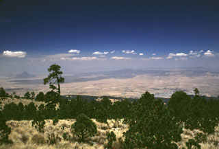 The light-colored area just below the right horizon is the floor of the 15 x 21 km Los Humeros caldera. It is seen here from the SE across the Serdán-Oriental basin from the flanks of Cofre de Perote volcano. Caldera formation during the mid-Pleistocene was followed by extrusion of voluminous lava flows during the late-Pleistocene or Holocene. These flows form the dark-colored area extending across the basin. The peak in the distance to the left is Cerro Pizarro.
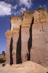 A quarry wall on the lower NW flank of Cofre de Perote volcano exposes a cross-section through part of the Xáltipan Ignimbrite, which erupted about 460,000 years ago and resulted in the formation of Los Humeros caldera. This massive 230 km3 ignimbrite covers a 3,500 km2 area and extends at least 50 km to the coastal plain. The mostly non-welded rhyolitic ignimbrite is overlain by co-ignimbrite airfall tuffs and eight airfall lapilli tuffs.
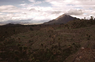 During the late-Pleistocene or Holocene, voluminous andesite and basaltic andesite lava flows erupted from scoria cones on the southern caldera rim and flowed long distances down the flank. The age of the flows is not known precisely, but the roughly 6,000-year-old Cantona archaeological site in this photo was constructed on top of the flows. A meteorological cloud on the horizon drifts from the summit of Cerro Pizarro, the northernmost lava dome of the Serdán-Oriental volcanic field.
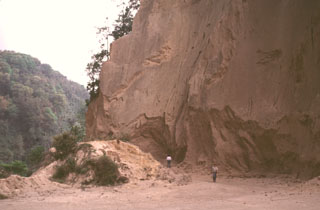 A quarry along the road between Teocelo and Cosautlán de Carvajal exposes thick deposits of the 230 km3 Xáltipan Ignimbrite from Los Humeros volcano. This outcrop lies about 50 km SE of Los Humeros, beyond the Pico de Orizaba-Cofre de Perote range, much of which post-dates the 460,000-year-old ignimbrite. Eruption of the Xáltipan Ignimbrite, which covered an area of about 3,500 km2, resulted in the formation of a 15 x 21 km wide caldera.
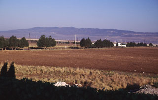 The broad ridge in the distance to the NW is Los Humeros, the easternmost of a series of large silicic volcanic centers with active geothermal systems located north of the axis of the Mexican Volcanic Belt. Eruption of the Xáltipan Ignimbrite about 460,000 years ago resulted in formation of the 15 x 21 km Los Humeros caldera. Recent eruptions at Los Humeros produced extensive basaltic lava flows; hot springs and fumarolic activity continue at Los Humeros, which has a producing geothermal field.
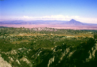 The summit of the Cerro Pinto lava dome on the western side of the Serdán-Oriental basin provides an overview of the crater floor of Cerro Xalapasco tuff cone in the foreground. Pyroclastic surge deposits associated with Cerro Xalapasco were emplaced in a relatively dry eruptive environment. The peak to the far right is Cerro Pizarro, a lava dome at the northern end of the Serdán-Oriental. The flat ridge stretching across the horizon to the north is Los Humeros caldera.
 The fresh-looking lava flows at the top of the image were erupted from Los Humeros caldera (just out of view to the north). The basaltic and andesitic lava flows extend up to about 15 km from the caldera rim. The flows have not been dated precisely, but are younger than 20,000 years and could in part be of Holocene age. The Tepeyahualco (left) and Limón (right) lava flows bracket circular 3100-m-high Cerro Pizarro lava dome (right center), the northernmost feature of the Serdán-Oriental volcanic field.
 The following 25 samples associated with this volcano can be found in the Smithsonian's NMNH Department of Mineral Sciences collections, and may be availble for research (contact the Rock and Ore Collections Manager). Catalog number links will open a window with more information.
| Catalog Number | Sample Description | Lava Source | Collection Date |
|---|---|---|---|
| NMNH 117450-55 | Obsidian | Oyameles Flow | -- |
| NMNH 117450-57 | Obsidian | Oyameles Flow | -- |
| NMNH 117450-58 | Obsidian | Cueva Ahumada Lava | -- |
| NMNH 117450-59 | Obsidian | Oyameles Flow | -- |
| NMNH 117450-63 | Obsidian | -- | -- |
| NMNH 117551-100 | Unidentified | -- | -- |
| NMNH 117551-101 | Unidentified | -- | -- |
| NMNH 117551-102 | Unidentified | -- | -- |
| NMNH 117551-103 | Unidentified | -- | -- |
| NMNH 117551-104 | Unidentified | -- | -- |
| NMNH 117551-105 | Unidentified | -- | -- |
| NMNH 117551-86 | Unidentified | -- | -- |
| NMNH 117551-87 | Unidentified | -- | -- |
| NMNH 117551-88 | Unidentified | -- | -- |
| NMNH 117551-89 | Unidentified | -- | -- |
| NMNH 117551-90 | Unidentified | -- | -- |
| NMNH 117551-91 | Unidentified | -- | -- |
| NMNH 117551-92 | Unidentified | -- | -- |
| NMNH 117551-93 | Unidentified | -- | -- |
| NMNH 117551-94 | Unidentified | -- | -- |
| NMNH 117551-95 | Unidentified | -- | -- |
| NMNH 117551-96 | Unidentified | -- | -- |
| NMNH 117551-97 | Unidentified | -- | -- |
| NMNH 117551-98 | Unidentified | -- | -- |
| NMNH 117551-99 | Unidentified | -- | -- |
| Copernicus Browser | The Copernicus Browser replaced the Sentinel Hub Playground browser in 2023, to provide access to Earth observation archives from the Copernicus Data Space Ecosystem, the main distribution platform for data from the EU Copernicus missions. |
| MIROVA | Middle InfraRed Observation of Volcanic Activity (MIROVA) is a near real time volcanic hot-spot detection system based on the analysis of MODIS (Moderate Resolution Imaging Spectroradiometer) data. In particular, MIROVA uses the Middle InfraRed Radiation (MIR), measured over target volcanoes, in order to detect, locate and measure the heat radiation sourced from volcanic activity. |
| MODVOLC Thermal Alerts | Using infrared satellite Moderate Resolution Imaging Spectroradiometer (MODIS) data, scientists at the Hawai'i Institute of Geophysics and Planetology, University of Hawai'i, developed an automated system called MODVOLC to map thermal hot-spots in near real time. For each MODIS image, the algorithm automatically scans each 1 km pixel within it to check for high-temperature hot-spots. When one is found the date, time, location, and intensity are recorded. MODIS looks at every square km of the Earth every 48 hours, once during the day and once during the night, and the presence of two MODIS sensors in space allows at least four hot-spot observations every two days. Each day updated global maps are compiled to display the locations of all hot spots detected in the previous 24 hours. There is a drop-down list with volcano names which allow users to 'zoom-in' and examine the distribution of hot-spots at a variety of spatial scales. |
|
WOVOdat
Single Volcano View Temporal Evolution of Unrest Side by Side Volcanoes |
WOVOdat is a database of volcanic unrest; instrumentally and visually recorded changes in seismicity, ground deformation, gas emission, and other parameters from their normal baselines. It is sponsored by the World Organization of Volcano Observatories (WOVO) and presently hosted at the Earth Observatory of Singapore.
GVMID Data on Volcano Monitoring Infrastructure The Global Volcano Monitoring Infrastructure Database GVMID, is aimed at documenting and improving capabilities of volcano monitoring from the ground and space. GVMID should provide a snapshot and baseline view of the techniques and instrumentation that are in place at various volcanoes, which can be use by volcano observatories as reference to setup new monitoring system or improving networks at a specific volcano. These data will allow identification of what monitoring gaps exist, which can be then targeted by remote sensing infrastructure and future instrument deployments. |
| Volcanic Hazard Maps | The IAVCEI Commission on Volcanic Hazards and Risk has a Volcanic Hazard Maps database designed to serve as a resource for hazard mappers (or other interested parties) to explore how common issues in hazard map development have been addressed at different volcanoes, in different countries, for different hazards, and for different intended audiences. In addition to the comprehensive, searchable Volcanic Hazard Maps Database, this website contains information about diversity of volcanic hazard maps, illustrated using examples from the database. This site is for educational purposes related to volcanic hazard maps. Hazard maps found on this website should not be used for emergency purposes. For the most recent, official hazard map for a particular volcano, please seek out the proper institutional authorities on the matter. |
| IRIS seismic stations/networks | Incorporated Research Institutions for Seismology (IRIS) Data Services map showing the location of seismic stations from all available networks (permanent or temporary) within a radius of 0.18° (about 20 km at mid-latitudes) from the given location of Los Humeros. Users can customize a variety of filters and options in the left panel. Note that if there are no stations are known the map will default to show the entire world with a "No data matched request" error notice. |
| UNAVCO GPS/GNSS stations | Geodetic Data Services map from UNAVCO showing the location of GPS/GNSS stations from all available networks (permanent or temporary) within a radius of 20 km from the given location of Los Humeros. Users can customize the data search based on station or network names, location, and time window. Requires Adobe Flash Player. |
| DECADE Data | The DECADE portal, still in the developmental stage, serves as an example of the proposed interoperability between The Smithsonian Institution's Global Volcanism Program, the Mapping Gas Emissions (MaGa) Database, and the EarthChem Geochemical Portal. The Deep Earth Carbon Degassing (DECADE) initiative seeks to use new and established technologies to determine accurate global fluxes of volcanic CO2 to the atmosphere, but installing CO2 monitoring networks on 20 of the world's 150 most actively degassing volcanoes. The group uses related laboratory-based studies (direct gas sampling and analysis, melt inclusions) to provide new data for direct degassing of deep earth carbon to the atmosphere. |
| Large Eruptions of Los Humeros | Information about large Quaternary eruptions (VEI >= 4) is cataloged in the Large Magnitude Explosive Volcanic Eruptions (LaMEVE) database of the Volcano Global Risk Identification and Analysis Project (VOGRIPA). |
| EarthChem | EarthChem develops and maintains databases, software, and services that support the preservation, discovery, access and analysis of geochemical data, and facilitate their integration with the broad array of other available earth science parameters. EarthChem is operated by a joint team of disciplinary scientists, data scientists, data managers and information technology developers who are part of the NSF-funded data facility Integrated Earth Data Applications (IEDA). IEDA is a collaborative effort of EarthChem and the Marine Geoscience Data System (MGDS). |

