The Global Volcanism Program has no activity reports available for Tequila.
The Global Volcanism Program has no Weekly Reports available for Tequila.
The Global Volcanism Program has no Bulletin Reports available for Tequila.
This compilation of synonyms and subsidiary features may not be comprehensive. Features are organized into four major categories: Cones, Craters, Domes, and Thermal Features. Synonyms of features appear indented below the primary name. In some cases additional feature type, elevation, or location details are provided.
Cones |
||||
| Feature Name | Feature Type | Elevation | Latitude | Longitude |
| Saavedra, Cerro los | Cone | |||
| Tomasillo, Cerro | Stratovolcano | 2160 m | 20° 45' 0" N | 103° 48' 0" W |
|
|
||||||||||||||||||
The Global Volcanism Program is not aware of any Holocene eruptions from Tequila. If this volcano has had large eruptions (VEI >= 4) prior to 10,000 years ago, information might be found on the Tequila page in the LaMEVE (Large Magnitude Explosive Volcanic Eruptions) database, a part of the Volcano Global Risk Identification and Analysis Project (VOGRIPA).
There is no Deformation History data available for Tequila.
There is no Emissions History data available for Tequila.
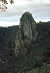 The dramatic spine in the summit crater of Tequila volcano rises 300 m above the crater floor. The dacitic spine, similar to the one at Sangangüey volcano, has been dated at 210,000 years and occupies a summit depression that is breached to the NE. The spine appears to represent the latest activity from the central vent of Tequila.
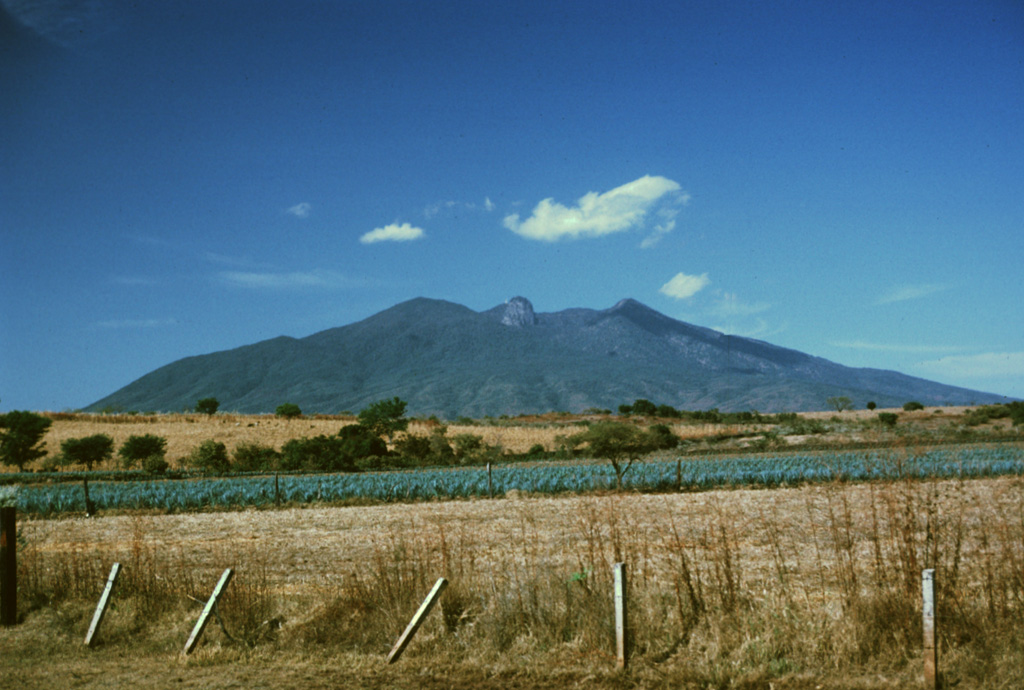
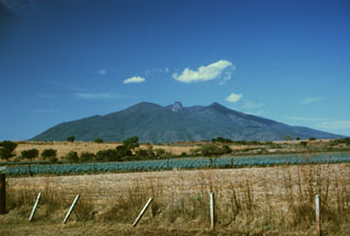 Volcán Tequila is an eroded andesitic-dacitic volcano of Pleistocene age that rises about 1800 m above the surrounding plains. Tequila is the SE-most of a chain of calc-alkaline stratovolcanoes NW of Guadalajara. A prominent 300-m-high summit spine, similar to that at Sangangüey volcano, can be seen here in the center of the summit crater, which was been breached to the NE, in the direction of the photo. The volcano is surrounded by a series of older flank rhyolitic lava domes, obsidian flows, and basaltic cinder cones.
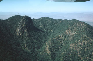 The summit depression of Tequila volcano is breached narrowly to the NE and originated from erosional excavation. A prominent 300-m-high dacitic spine, left after erosional removal of softer rocks surrounding the vent, forms the dramatic steep-sided peak at the left. The spine was dated at about 210,000 years and probably represents the latest activity from the central vent.
 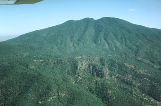 The south flank of the erosionally modified Tequila volcano is seen in an aerial view. The oldest lava flows from the Pleistocene stratovolcano overlie a south-flank rhyolitic lava dome dated at about 460,000 years. Summit crater activity ceased about 210,000 years ago, but flank eruptions producing andesitic lava flows and basaltic cinder cones continued until the late Pleistocene.
Maps are not currently available due to technical issues.
The maps shown below have been scanned from the GVP map archives and include the volcano on this page. Clicking on the small images will load the full 300 dpi map. Very small-scale maps (such as world maps) are not included.
There are no samples for Tequila in the Smithsonian's NMNH Department of Mineral Sciences Rock and Ore collection.
| Copernicus Browser | The Copernicus Browser replaced the Sentinel Hub Playground browser in 2023, to provide access to Earth observation archives from the Copernicus Data Space Ecosystem, the main distribution platform for data from the EU Copernicus missions. |
|
WOVOdat
Single Volcano View Temporal Evolution of Unrest Side by Side Volcanoes |
WOVOdat is a database of volcanic unrest; instrumentally and visually recorded changes in seismicity, ground deformation, gas emission, and other parameters from their normal baselines. It is sponsored by the World Organization of Volcano Observatories (WOVO) and presently hosted at the Earth Observatory of Singapore.
GVMID Data on Volcano Monitoring Infrastructure The Global Volcano Monitoring Infrastructure Database GVMID, is aimed at documenting and improving capabilities of volcano monitoring from the ground and space. GVMID should provide a snapshot and baseline view of the techniques and instrumentation that are in place at various volcanoes, which can be use by volcano observatories as reference to setup new monitoring system or improving networks at a specific volcano. These data will allow identification of what monitoring gaps exist, which can be then targeted by remote sensing infrastructure and future instrument deployments. |
| IRIS seismic stations/networks | Incorporated Research Institutions for Seismology (IRIS) Data Services map showing the location of seismic stations from all available networks (permanent or temporary) within a radius of 0.18° (about 20 km at mid-latitudes) from the given location of Tequila. Users can customize a variety of filters and options in the left panel. Note that if there are no stations are known the map will default to show the entire world with a "No data matched request" error notice. |
| UNAVCO GPS/GNSS stations | Geodetic Data Services map from UNAVCO showing the location of GPS/GNSS stations from all available networks (permanent or temporary) within a radius of 20 km from the given location of Tequila. Users can customize the data search based on station or network names, location, and time window. Requires Adobe Flash Player. |
| Large Eruptions of Tequila | Information about large Quaternary eruptions (VEI >= 4) is cataloged in the Large Magnitude Explosive Volcanic Eruptions (LaMEVE) database of the Volcano Global Risk Identification and Analysis Project (VOGRIPA). |
| EarthChem | EarthChem develops and maintains databases, software, and services that support the preservation, discovery, access and analysis of geochemical data, and facilitate their integration with the broad array of other available earth science parameters. EarthChem is operated by a joint team of disciplinary scientists, data scientists, data managers and information technology developers who are part of the NSF-funded data facility Integrated Earth Data Applications (IEDA). IEDA is a collaborative effort of EarthChem and the Marine Geoscience Data System (MGDS). |

