The Global Volcanism Program has no activity reports available for Utila Volcanic Center.
The Global Volcanism Program has no Weekly Reports available for Utila Volcanic Center.
The Global Volcanism Program has no Bulletin Reports available for Utila Volcanic Center.
|
|
||||||||||||||||||||||||||
The Global Volcanism Program is not aware of any Holocene eruptions from Utila Volcanic Center. If this volcano has had large eruptions (VEI >= 4) prior to 12,000 years ago, information might be found on the Utila Volcanic Center page in the LaMEVE (Large Magnitude Explosive Volcanic Eruptions) database, a part of the Volcano Global Risk Identification and Analysis Project (VOGRIPA).
This compilation of synonyms and subsidiary features may not be comprehensive. Features are organized into four major categories: Cones, Craters, Domes, and Thermal Features. Synonyms of features appear indented below the primary name. In some cases additional feature type, elevation, or location details are provided.
Cones |
||||
| Feature Name | Feature Type | Elevation | Latitude | Longitude |
| Colibri Hill
Stuart Hill Stuert Hill |
Pyroclastic cone | 34 m | 16° 6' 31.00" N | 86° 53' 54.00" W |
| Pumpkin Hill | Pyroclastic cone | 51 m | 16° 7' 11.00" N | 86° 52' 57.00" W |
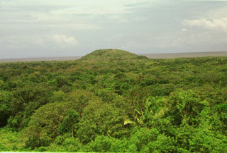 Pumpkin Hill, a small pyroclastic cone at the NE end of Utila Island, is seen here across a forest from Stuert Hill, the other pyroclastic cone on the eastern side of the island. The two cones lie about 2 km apart and were constructed over flat-lying terraces that cover much of the elongated, 3 x 11 km wide island. Alkaline olivine-basaltic lava flows erupted from the cones cover much of the eastern side of the island and underlie the forest in this photo. The Caribbean Sea lies in the background to the NE.
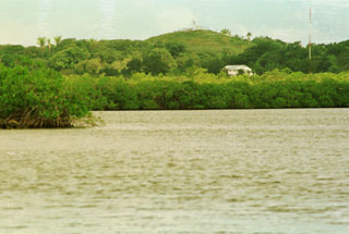 The low peak in the background is Stuert Hill, a pyroclastic cone that rises only 51 m above the Caribbean Sea at the eastern end of Utila Island. The cone is seen here from across East Harbor at the SE end of the island. The cone forms an arcuate ridge composed of ejected basaltic tuffs and abundant blocks that include coral fragments, limestone, and metamorphic rocks.
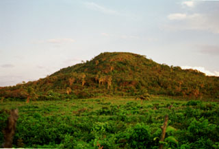 Pumpkin Hill, a low pyroclastic cone reaching only 74 m above sea level, is the high point of Utila Island. The cone occupies the NE tip of the island and consists of stratified basaltic lapilli and tuffs containing abundant blocks and small fragments of coral. The vent of the cone appears to lie on this side near its northern base, but only the southern half of the cone remains.
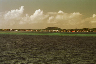 The low pyroclastic cone Stuert Hill (also spelled Stuart Hill) rises beyond Utila, the largest village on the island of the same name. A ferry connects the village of Utila, formerly known as East Harbor, to the mainland of Honduras. Most of the island consists of flat-lying uplifted coral reefs; volcanic rocks are found only at the eastern end of the island.
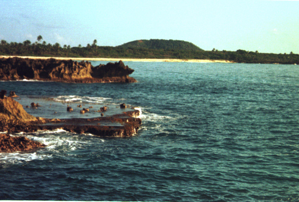
 The low peak in the distance is Pumpkin Hill, a pyroclastic cone at the NE end of Utila Island. The small 74-m-high cone was erupted onto a coral-capped erosional surface forming the cliffs in the foreground and marks the high point on the island. Basaltic lavas and tuffs blanket terraces on the NE side of Utila. The island lies in the Caribbean Sea off the northern coast of Honduras and is the easternmost and lowest of the Bay Islands at the southern edge of the submarine Bartlett Trough.
 There are no samples for Utila Volcanic Center in the Smithsonian's NMNH Department of Mineral Sciences Rock and Ore collection.
| Copernicus Browser | The Copernicus Browser replaced the Sentinel Hub Playground browser in 2023, to provide access to Earth observation archives from the Copernicus Data Space Ecosystem, the main distribution platform for data from the EU Copernicus missions. |
|
WOVOdat
Single Volcano View Temporal Evolution of Unrest Side by Side Volcanoes |
WOVOdat is a database of volcanic unrest; instrumentally and visually recorded changes in seismicity, ground deformation, gas emission, and other parameters from their normal baselines. It is sponsored by the World Organization of Volcano Observatories (WOVO) and presently hosted at the Earth Observatory of Singapore.
GVMID Data on Volcano Monitoring Infrastructure The Global Volcano Monitoring Infrastructure Database GVMID, is aimed at documenting and improving capabilities of volcano monitoring from the ground and space. GVMID should provide a snapshot and baseline view of the techniques and instrumentation that are in place at various volcanoes, which can be use by volcano observatories as reference to setup new monitoring system or improving networks at a specific volcano. These data will allow identification of what monitoring gaps exist, which can be then targeted by remote sensing infrastructure and future instrument deployments. |
| IRIS seismic stations/networks | Incorporated Research Institutions for Seismology (IRIS) Data Services map showing the location of seismic stations from all available networks (permanent or temporary) within a radius of 0.18° (about 20 km at mid-latitudes) from the given location of Utila Volcanic Center. Users can customize a variety of filters and options in the left panel. Note that if there are no stations are known the map will default to show the entire world with a "No data matched request" error notice. |
| UNAVCO GPS/GNSS stations | Geodetic Data Services map from UNAVCO showing the location of GPS/GNSS stations from all available networks (permanent or temporary) within a radius of 20 km from the given location of Utila Volcanic Center. Users can customize the data search based on station or network names, location, and time window. Requires Adobe Flash Player. |
| Large Eruptions of Utila Volcanic Center | Information about large Quaternary eruptions (VEI >= 4) is cataloged in the Large Magnitude Explosive Volcanic Eruptions (LaMEVE) database of the Volcano Global Risk Identification and Analysis Project (VOGRIPA). |
| EarthChem | EarthChem develops and maintains databases, software, and services that support the preservation, discovery, access and analysis of geochemical data, and facilitate their integration with the broad array of other available earth science parameters. EarthChem is operated by a joint team of disciplinary scientists, data scientists, data managers and information technology developers who are part of the NSF-funded data facility Integrated Earth Data Applications (IEDA). IEDA is a collaborative effort of EarthChem and the Marine Geoscience Data System (MGDS). |

