Honduras Volcanoes
A map display is currently under development.
Honduras has 3 Holocene volcanoes. Note that as a scientific organization we provide these listings for informational purposes only, with no international legal or policy implications. Volcanoes will be included on this list if they are within the boundaries of a country, on a shared boundary or area, in a remote territory, or within a maritime Exclusive Economic Zone. Bolded volcanoes have erupted within the past 20 years. Suggestions and data updates are always welcome ().
| Volcano Name | Last Eruption | Volcanic Region | Primary Landform |
|---|---|---|---|
| Isla del Tigre | Unknown - Evidence Credible | Central America Volcanic Arc | Composite |
| Lago Yojoa | 7638 BCE | Central America Volcanic Arc | Cluster |
| Isla Zacate Grande | Unknown - Evidence Credible | Central America Volcanic Arc | Composite |
Chronological listing of known Holocene eruptions (confirmed or uncertain) from volcanoes in Honduras. Bolded eruptions indicate continuing activity.
| Volcano Name | Start Date | Stop Date | Certainty | VEI | Evidence |
|---|---|---|---|---|---|
| Lago Yojoa | 7638 BCE ± 118 years | Unknown | Confirmed | Isotopic: 14C (calibrated) | |
| Lago Yojoa | 11073 BCE ± 173 years | Unknown | Confirmed | Isotopic: 14C (calibrated) |
Honduras has 6 Pleistocene volcanoes. Note that as a scientific organization we provide these listings for informational purposes only, with no international legal or policy implications. Volcanoes will be included on this list if they are within the boundaries of a country, on a shared boundary or area, in a remote territory, or within a maritime Exclusive Economic Zone. Suggestions and data updates are always welcome ().
| Volcano Name | Volcanic Region | Primary Landform |
|---|---|---|
| Cerro Calanterique | Central America Volcanic Arc | Minor |
| Cerro Gavilantepeque | Central America Volcanic Arc | Shield |
| Cerro de Hule | Central America Volcanic Arc | Shield |
| Montaña de Izopo | Central America Volcanic Arc | Shield |
| El Pedregal | Central America Volcanic Arc | Shield |
| Utila Volcanic Center | Central America Volcanic Arc | Minor |
There are 22 photos available for volcanoes in Honduras.
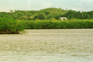
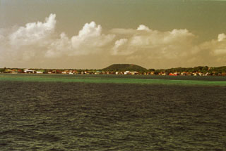 The low pyroclastic cone Stuert Hill (also spelled Stuart Hill) rises beyond Utila, the largest village on the island of the same name. A ferry connects the village of Utila, formerly known as East Harbor, to the mainland of Honduras. Most of the island consists of flat-lying uplifted coral reefs; volcanic rocks are found only at the eastern end of the island.
Photo by Rick Wunderman, 1999 (Smithsonian Institution).
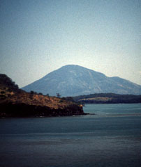
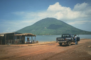 The morphologically youthful Isla el Tigre is a small, 5-km-wide island located south of Isla Zacate Grande in the Gulf of Fonseca. The conical 783-m-high basaltic stratovolcano, viewed here from the NE across a narrow 2-km-wide strait from Zacate Grande, is the southernmost volcano of Honduras.
 Photo by Mike Carr, 1991 (Rutgers University).
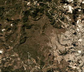 El Pedregal is near the center of this January 2019 Planet Labs satellite image monthly mosaic (N is at the top; the image is approximately 10 km across. Remnants of lava flows and separate vents occur over broad areas to the W and NW, and the capital city of Tegucigalpa is to the E.
Satellite image courtesy of Planet Labs Inc., 2019 (https://www.planet.com/).
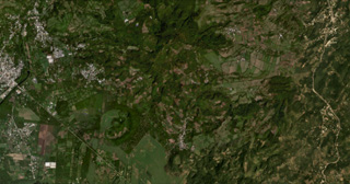 The Lake Yojoa volcanic field in Honduras is located along the northern shore of Lake Yojoa, shown in this October 2019 Planet Labs satellite image monthly mosaic (N is at the top; this image is approximately 12 km across). The field contains scoria and spatter cones and lava flows, with the Cerro el Hoyo in the bottom-center, to the W is the smaller Cerro el Copito cone on the other side of the larger unnamed crater, and Cerro Babilonia in the center of the top of the image.
Satellite image courtesy of Planet Labs Inc., 2019 (https://www.planet.com/).
 Isla el Tigre stratovolcano forms a small island in the Gulf of Fonseca across a narrow strait from Isla Zacate Grande (upper right), a volcano forming a peninsula on the Honduras mainland. A single satellitic cone lies immediately south of the town of San Pablo on the NNW side of the 5-km-wide island (upper left).
Aerial photo by Instituto Geográfico Nacional El Salvador.
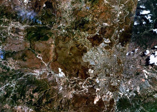 The volcano near the center of this NASA Landsat image (with north to the top) is El Pedregal, the most prominent Quaternary volcano in the highlands of central Honduras. This low-angle basaltic shield volcano was constructed on a high plateau of Miocene ignimbrites immediately west of the capital city of Tegucigalpa, which covers much of the lower-right quadrant of this image. Isolated remnants of basaltic lava flows from El Pedregal and separate vents occur over broad areas to the west and NW.
NASA Landsat 7 image (worldwind.arc.nasa.gov)
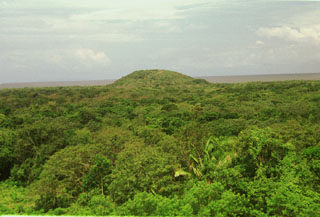
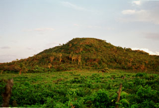
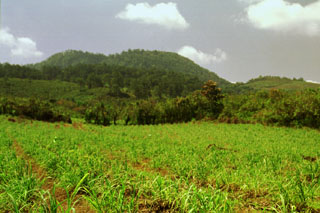 This eastern side of forested Cerro Babilonia cinder cone rises above fields north of Lake Yojoa in north-central Honduras. The 1090-m-high cone is the highest of a chain of Pleistocene-to-Holocene scoria cones at the northern end of the lake. The cones were constructed along orthogonal NW-SE- and NE-SW-trending lines and consist of basaltic scoria and agglutinate. The are typically 100-200 m in height and several contain well-preserved craters. Lava flows radiate in all directions from the cones.
 Photo by Rick Wunderman, 1999 (Smithsonian Institution).
 The SW-most of a chain of NE-trending cinder cones is the largest of a cluster of cones north of Lake Yojoa. This large cone was constructed at the intersection of two roughly orthogonal chains of young pyroclastic cones. The cones of the Lake Yojoa volcanic field were built along fissures; these parallel faults that also define the rectilinear shores of the lake and cut Cretaceous limestones on the west side of the lake.
Photo by Rick Wunderman, 1999 (Smithsonian Institution).
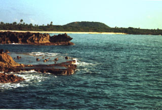
 Pumpkin Hill, a small pyroclastic cone at the NE end of Utila Island, is seen here across a forest from Stuert Hill, the other pyroclastic cone on the eastern side of the island. The two cones lie about 2 km apart and were constructed over flat-lying terraces that cover much of the elongated, 3 x 11 km wide island. Alkaline olivine-basaltic lava flows erupted from the cones cover much of the eastern side of the island and underlie the forest in this photo. The Caribbean Sea lies in the background to the NE.
Photo by Rick Wunderman, 1999 (Smithsonian Institution).
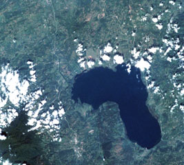 The Lake Yojoa volcanic field forms the entire northern shore of the 10 x 12 km lake, the largest in Honduras, in this International Space Station image with north to the upper left. Cretaceous limestones lie west of the lake, and Tertiary volcanic rocks to the east. Vents of the volcanic field, which extends to the top of the image, are concentrated along two NW- and NE-trending lines. The Lake Yojoa volcanic field has produced both tholeiitic and alkaline basaltic rocks.
NASA International Space Station image ISS001-350-18, 2001 (http://eol.jsc.nasa.gov/).
 Cerro el Hoyo lies at the SE end of a subsidiary NW-SE-trending chain of pyroclastic cones of the Lake Yojoa volcanic field about 2 km NE of the lakeshore. The cones are surrounded by lava fields that are partially tholeiitic in composition, but mostly consist of trachytes, trachybasalts, and trachyandesites with large phenocrysts of sanadine and anorthoclase.
Photo by Rick Wunderman, 1999 (Smithsonian Institution).
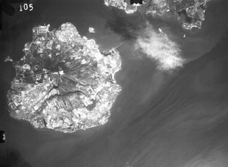
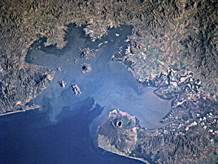 Young volcanoes dot the surface and anchor the shores of the Gulf of Fonseca, which forms the coastline of three countries. Conchagua volcano occupies the wedge-shaped peninsula (left-center) in eastern El Salvador, while Cosigüina volcano forms the prominent peninsula across the bay in Nicaragua. Clockwise from the top are the islands of Zacate Grande and El Tigre in Honduras and Meanguera and Conchaguita in El Salvador. The mouth of the Gulf of Fonseca is about 30 km wide.
NASA Space Shuttle image STS82-731-83, 1997 (http://eol.jsc.nasa.gov/).
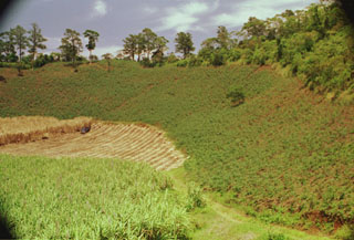 A large low-rimmed crater lies immediately WNW of Cerro el Hoyo. The floor of the crater has been planted with sugar cane, and other crops line the walls of the crater. The scale of the 1-km-wide crater is deceiving--note the barely visible truck and sugar cane workers on the crater floor at the left center.
Photo by Rick Wunderman, 1999 (Smithsonian Institution).
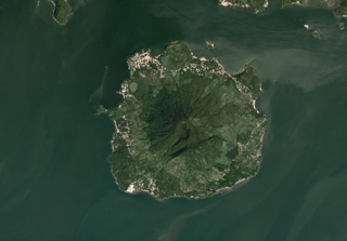 The 5.5-km-wide Isla del Tigre is located in the Gulf of Fonseca in Honduras, shown in this October 2019 Planet Labs satellite image monthly mosaic (N is at the top). There is a crater just below the summit on the southern flank as well as several other flank craters including El Vigía on the NW flank, just NE of the lake near the shore.
Satellite image courtesy of Planet Labs Inc., 2019 (https://www.planet.com/).
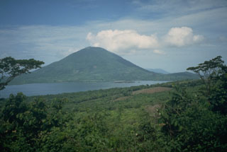
 Zacate Grande volcano, seen here from Punta el Chiquirín at the eastern tip of El Salvador, forms a low 7 x 10 km wide island across a narrow strait from the end of a peninsula extending into the Gulf of Fonseca. At least seven satellitic cones are located near the base of the 640-m-high dissected basaltic stratovolcano. Some of these, including the symmetrical cone of Isla Gueguensi, are of probable Holocene age. The northern tip of the Salvadoran island of Zacatillo forms the ridge in the center of the photo.
Photo by Rick Wunderman, 1999 (Smithsonian Institution).
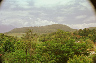
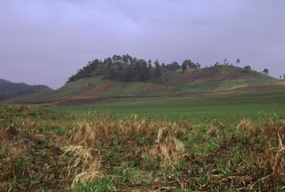
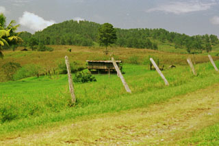 El Volcán is the oldest and most dissected of a group of pyroclastic cones north of Lake Yojoa. El Volcán lies at the SE end of the cluster of cones near the lake. The cone, now mantled by scoria from younger cones, fed a series of basaltic lava flows that underlie a flat valley to the SE (to the right of this photo).
Photo by Rick Wunderman, 1999 (Smithsonian Institution).
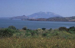
 Isla el Tigre in Honduras is seen here across the Gulf of Fonseca from Punta el Chiquirín on the eastern tip of El Salvador. The morphologically youthful volcano rises 783 m above the gulf and is the southernmost in Honduras. A valley on the SW flank (right) extends to the sea and disrupts the symmetry of the volcano.
Photo by Rick Wunderman, 1999 (Smithsonian Institution).
 The low peak in the distance is Pumpkin Hill, a pyroclastic cone at the NE end of Utila Island. The small 74-m-high cone was erupted onto a coral-capped erosional surface forming the cliffs in the foreground and marks the high point on the island. Basaltic lavas and tuffs blanket terraces on the NE side of Utila. The island lies in the Caribbean Sea off the northern coast of Honduras and is the easternmost and lowest of the Bay Islands at the southern edge of the submarine Bartlett Trough.
 Photo by Rick Wunderman, 1999 (Smithsonian Institution).
 Pumpkin Hill, a low pyroclastic cone reaching only 74 m above sea level, is the high point of Utila Island. The cone occupies the NE tip of the island and consists of stratified basaltic lapilli and tuffs containing abundant blocks and small fragments of coral. The vent of the cone appears to lie on this side near its northern base, but only the southern half of the cone remains.
Photo by Rick Wunderman, 1999 (Smithsonian Institution).
 Isla el Tigre is a small, 5-km-wide island across a narrow strait south of Isla Zacate Grande in the Gulf of Fonseca of Honduras. The conical, 783-m-high stratovolcano, seen here from the NE on Zacate Grande island, is less dissected than Zacate Grande volcano and is of probable Holocene age. A single satellitic cone (far right) overlooks the NW-flank town of Amapala, Honduras' only Pacific port. The peak in the distance beyond the right-hand flank is the volcanic island of Meangura.
Photo by Mike Carr, 1991 (Rutgers University).
 The low peak in the background is Stuert Hill, a pyroclastic cone that rises only 51 m above the Caribbean Sea at the eastern end of Utila Island. The cone is seen here from across East Harbor at the SE end of the island. The cone forms an arcuate ridge composed of ejected basaltic tuffs and abundant blocks that include coral fragments, limestone, and metamorphic rocks.
Photo by Rick Wunderman, 1999 (Smithsonian Institution).
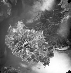 Isla Zacate Grande forms a peninsula bounded by the Gulf of Fonseca at the bottom of the photo and Chismuyo Bay at the left. Deep erosional valleys descend from the summit of the eroded stratovolcano, which is connected to the Honduras mainland by tidal flats cut by numerous small estuaries seen at the upper right. More than a half dozen younger satellitic cones, some of which may be Holocene in age, surround the volcano. The tip of Isla el Tigre lies across the narrow 2-km-wide strait from Zacate Grande.
Aerial photo by Instituto Geográfico Nacional El Salvador.
This is a compilation of Honduras volcano information sources, such as official monitoring or other government agencies.
| Volcanic Ash Advisory Center | |
|---|---|
| Washington Volcanic Ash Advisory Center (VAAC) | |
| - Washington VAAC Archive | |
| - Washington VAAC Notices | |