No sign of activity despite seismic swarms in the late 1970's
"Seismic swarms, which occurred in the late 1970's, had indicated the possibility of an active magma chamber below the volcano. No sign of activity was detected during fieldwork. The most recent (but pre-historic) activity at Rota was a Plinian dacite eruption followed by andesite-dacite lava flows."
Information Contacts: B. van Wyk de Vries, O. Castellón, A. Murales, and V. Tenorio, INETER, Apartado 1761, Managua, Nicaragua.
The Global Volcanism Program has no Weekly Reports available for Rota.
Reports are organized chronologically and indexed below by Month/Year (Publication Volume:Number), and include a one-line summary. Click on the index link or scroll down to read the reports.
No sign of activity despite seismic swarms in the late 1970's
"Seismic swarms, which occurred in the late 1970's, had indicated the possibility of an active magma chamber below the volcano. No sign of activity was detected during fieldwork. The most recent (but pre-historic) activity at Rota was a Plinian dacite eruption followed by andesite-dacite lava flows."
Information Contacts: B. van Wyk de Vries, O. Castellón, A. Murales, and V. Tenorio, INETER, Apartado 1761, Managua, Nicaragua.
|
|
||||||||||||||||||||||||||
The Global Volcanism Program is not aware of any Holocene eruptions from Rota. If this volcano has had large eruptions (VEI >= 4) prior to 12,000 years ago, information might be found on the Rota page in the LaMEVE (Large Magnitude Explosive Volcanic Eruptions) database, a part of the Volcano Global Risk Identification and Analysis Project (VOGRIPA).
This compilation of synonyms and subsidiary features may not be comprehensive. Features are organized into four major categories: Cones, Craters, Domes, and Thermal Features. Synonyms of features appear indented below the primary name. In some cases additional feature type, elevation, or location details are provided.
Synonyms |
||||
| Orota | ||||
Domes |
||||
| Feature Name | Feature Type | Elevation | Latitude | Longitude |
| Bosque, El
San Ignacio del Bosque, Lomas Ojochal, Cerro |
Dome | 238 m | 12° 36' 27.00" N | 86° 44' 36.00" W |
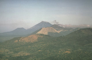 Cerro Negro volcano provides a vantage point for a NW-looking view down the Marrabios Range volcanic chain. The forested slopes in the foreground are part of Rota volcano. The light-colored conical peak in the center is Volcán Santa Clara, part of the Telica volcanic complex, whose principal peak, Telica itself, just pokes its head above the horizon behind and to the right of Santa Clara. The large conical peak on the center horizon is San Cristóbal, the highest peak of the Marrabios Range. The satellitic peak of El Chonco is on the left horizon.
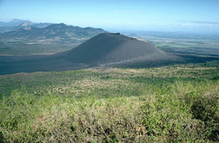 The unvegetated cone of Cerro Negro, the youngest volcano in Nicaragua, is seen here from the slopes of Las Pilas volcano at the end of its 1995 eruption. Lava flows in 1995 traveled to the NNE (right). Beyond Cerro Negro to the NW is the broad massif of Rota volcano. Unlike Telica and San Cristóbal volcanoes in the distance at the far upper left, Rota has had no historical eruptions.
 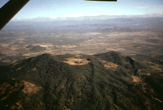 The deeply eroded, forested Rota stratovolcano is seen here in an aerial view from the south. The vegetated, 832-m-high volcano, also known as Orota, is truncated by a 1-km-wide circular crater. No historical eruptions are known from Volcán Rota, although seismic swarms occurred in 1986, 1989, and 1992. Two small NNW-SSE-trending lava domes, El Bosque (also known as Lomas San Ignacio del Bosque or Cerro Ojochal) form the small forested cones visible on the plain at the left center, 2 km north of the flank of Rota.
 The low, forested Rota stratovolcano rises above fields to its west in the area between Cerro Negro volcano and the Telica volcanic complex. A 1-km-wide circular crater whose rim is lowest on the southern side lies at the summit. The latest eruption from Rota produced thick andesitic lava flows from a NE-trending fissure NW of the summit. No historical eruptions are known from Volcán Rota, although seismic swarms occurred in 1986, 1989, and 1992.
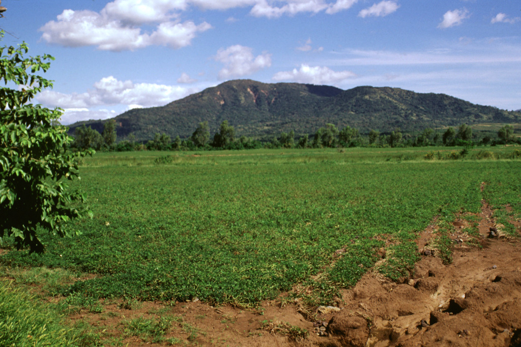
 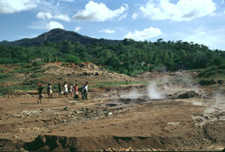 Forested Rota volcano rises above steaming ground of the San Jacinto thermal area at the eastern end of the Telica volcanic complex. Highway 26 between Telica and Malpaisillo crosses the low saddle between Rota and the Telica complex and provides easy access to the mud pots and steaming vents of the thermal area. Visitors to San Jacinto are accompanied by groups of vendors who live in settlements near the thermal area.
 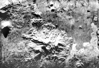 The deeply eroded Rota stratovolcano with its circular 1-km-wide summit crater lies at the bottom-center of this radar image. The latest eruption from the 832-m-high volcano produced thick andesitic lava flows NW of the summit, which extend nearly to the Malpaisillo road cutting diagonally across the image to the upper right. Two small NNW-SSE-trending lava domes (top-center), El Bosque, are located on the plain 2 km north of the flank of Rota (top-center). The Telica volcanic complex is visible at the upper left and lava flows from Las Pilas at the far right.
 There are no samples for Rota in the Smithsonian's NMNH Department of Mineral Sciences Rock and Ore collection.
| Copernicus Browser | The Copernicus Browser replaced the Sentinel Hub Playground browser in 2023, to provide access to Earth observation archives from the Copernicus Data Space Ecosystem, the main distribution platform for data from the EU Copernicus missions. |
|
WOVOdat
Single Volcano View Temporal Evolution of Unrest Side by Side Volcanoes |
WOVOdat is a database of volcanic unrest; instrumentally and visually recorded changes in seismicity, ground deformation, gas emission, and other parameters from their normal baselines. It is sponsored by the World Organization of Volcano Observatories (WOVO) and presently hosted at the Earth Observatory of Singapore.
GVMID Data on Volcano Monitoring Infrastructure The Global Volcano Monitoring Infrastructure Database GVMID, is aimed at documenting and improving capabilities of volcano monitoring from the ground and space. GVMID should provide a snapshot and baseline view of the techniques and instrumentation that are in place at various volcanoes, which can be use by volcano observatories as reference to setup new monitoring system or improving networks at a specific volcano. These data will allow identification of what monitoring gaps exist, which can be then targeted by remote sensing infrastructure and future instrument deployments. |
| IRIS seismic stations/networks | Incorporated Research Institutions for Seismology (IRIS) Data Services map showing the location of seismic stations from all available networks (permanent or temporary) within a radius of 0.18° (about 20 km at mid-latitudes) from the given location of Rota. Users can customize a variety of filters and options in the left panel. Note that if there are no stations are known the map will default to show the entire world with a "No data matched request" error notice. |
| UNAVCO GPS/GNSS stations | Geodetic Data Services map from UNAVCO showing the location of GPS/GNSS stations from all available networks (permanent or temporary) within a radius of 20 km from the given location of Rota. Users can customize the data search based on station or network names, location, and time window. Requires Adobe Flash Player. |
| Large Eruptions of Rota | Information about large Quaternary eruptions (VEI >= 4) is cataloged in the Large Magnitude Explosive Volcanic Eruptions (LaMEVE) database of the Volcano Global Risk Identification and Analysis Project (VOGRIPA). |
| EarthChem | EarthChem develops and maintains databases, software, and services that support the preservation, discovery, access and analysis of geochemical data, and facilitate their integration with the broad array of other available earth science parameters. EarthChem is operated by a joint team of disciplinary scientists, data scientists, data managers and information technology developers who are part of the NSF-funded data facility Integrated Earth Data Applications (IEDA). IEDA is a collaborative effort of EarthChem and the Marine Geoscience Data System (MGDS). |

