Dormancy continues but S-flank residents felt six earthquakes on 30 March
On 30 March 1997 residents in the S-flank settlement of San Vicente felt about six earthquakes between 0900 and 2100. One of these earthquakes took place at 1429; it was M 2.7 and its epicenter was 5 km SE of the volcano. No residents in other nearby settlements (Porvenir, Sucre, and Quesada) reported feeling these earthquakes.
About 10 days after the earthquakes, two dry-tiltmeters, measured every 2-3 years, showed differing results. One showed great changes but had been disturbed; the other, which was considered more reliable, had changed little. An April 1980 seismic swarm near Platanar, attributed to a local fault, continued for 2-3 weeks.
Information Contacts: E. Fernández, E. Duarte, V. Barboza, R. Van der Laat, E. Hernandez, M. Martinez, and R. Sáenz, Observatorio Vulcanológico y Sismológico de Costa Rica, Universidad Nacional (OVSICORI-UNA), Apartado 86, 3000 Heredia, Costa Rica.
The Global Volcanism Program has no Weekly Reports available for Platanar.
Reports are organized chronologically and indexed below by Month/Year (Publication Volume:Number), and include a one-line summary. Click on the index link or scroll down to read the reports.
Increased fumarolic activity and rumblings reported
Card 0568 (04 June 1969) Increased fumarolic activity and rumblings reported
The following is from a cable received on 3 June. "New or increased fumarolic activity together with earth rumblings reported by municipal authorities at Cerro Platanar . . . . Although close to Quesada immediate area of volcano extremely inaccessible. Such activity appears to be unusual."
Information Contacts: Richard Berg, American Embassy, San José, Costa Rica
No significant deformation since 1987
Dry-tilt data have shown no significant changes since 1987.
Information Contacts: E. Fernández, J. Barquero, R. Van der Laat, F. de Obadía, T. Marino, and R. Sáenz, OVSICORI; M. Martini, Univ di Firenze, Italy.
Seven years of dry-tilt measurements show no change
OVSICORI reported in January 1994 that two dry-tilt inclinometers installed in 1987 have thus far showed insignificant changes.
Information Contacts: E. Fernández, J. Barquero, R. Van der Laat, F. de Obaldia, T. Marino, V. Barboza, and R. Sáenz, OVSICORI.
Dormancy continues but S-flank residents felt six earthquakes on 30 March
On 30 March 1997 residents in the S-flank settlement of San Vicente felt about six earthquakes between 0900 and 2100. One of these earthquakes took place at 1429; it was M 2.7 and its epicenter was 5 km SE of the volcano. No residents in other nearby settlements (Porvenir, Sucre, and Quesada) reported feeling these earthquakes.
About 10 days after the earthquakes, two dry-tiltmeters, measured every 2-3 years, showed differing results. One showed great changes but had been disturbed; the other, which was considered more reliable, had changed little. An April 1980 seismic swarm near Platanar, attributed to a local fault, continued for 2-3 weeks.
Information Contacts: E. Fernández, E. Duarte, V. Barboza, R. Van der Laat, E. Hernandez, M. Martinez, and R. Sáenz, Observatorio Vulcanológico y Sismológico de Costa Rica, Universidad Nacional (OVSICORI-UNA), Apartado 86, 3000 Heredia, Costa Rica.
|
|
||||||||||||||||||||||||||||
The Global Volcanism Program is not aware of any Holocene eruptions from Platanar. If this volcano has had large eruptions (VEI >= 4) prior to 12,000 years ago, information might be found on the Platanar page in the LaMEVE (Large Magnitude Explosive Volcanic Eruptions) database, a part of the Volcano Global Risk Identification and Analysis Project (VOGRIPA).
This compilation of synonyms and subsidiary features may not be comprehensive. Features are organized into four major categories: Cones, Craters, Domes, and Thermal Features. Synonyms of features appear indented below the primary name. In some cases additional feature type, elevation, or location details are provided.
Synonyms |
||||
| Congo, Volcán | ||||
Cones |
||||
| Feature Name | Feature Type | Elevation | Latitude | Longitude |
| Aguas Zarcas | Pyroclastic cone | |||
| Azufrado | Stratovolcano | 2242 m | 10° 14' 35.00" N | 84° 20' 56.00" W |
| Barrantes, Loma | Pyroclastic cone | 290 m | 10° 26' 9.00" N | 84° 18' 27.00" W |
| Buenos Aires | Pyroclastic cone | 461 m | 10° 22' 48.00" N | 84° 18' 18.00" W |
| Chiles, Los | Pyroclastic cone | 250 m | 10° 27' 33.00" N | 84° 20' 31.00" W |
| Hermoso, Valle | Pyroclastic cone | 215 m | 10° 26' 52.00" N | 84° 20' 13.00" W |
| Juan Murillo | Pyroclastic cone | 518 m | 10° 23' 3.00" N | 84° 19' 48.00" W |
| Morera, Loma | Pyroclastic cone | 621 m | 10° 21' 48.00" N | 84° 19' 27.00" W |
| Palmira, Cerros | Stratovolcano | 2184 m | 10° 11' 24.00" N | 84° 21' 7.00" W |
| Pelón, Cerro | Stratovolcano | 2320 m | 10° 14' 54.00" N | 84° 21' 27.00" W |
| Pital, Loma | Pyroclastic cone | 160 m | ||
| Porvenir, Cerro | Stratovolcano | 2267 m | 10° 16' 15.00" N | 84° 21' 46.00" W |
| Quesada | Cone | 820 m | 10° 18' 32.00" N | 84° 27' 7.00" W |
| Siete, Cerro el | Stratovolcano | 2260 m | 10° 14' 42.00" N | 84° 21' 54.00" W |
| Vuelta Kopper | Pyroclastic cone | 290 m | 10° 26' 6.00" N | 84° 20' 6.00" W |
Craters |
||||
| Feature Name | Feature Type | Elevation | Latitude | Longitude |
| Chocosuela | Pleistocene caldera | |||
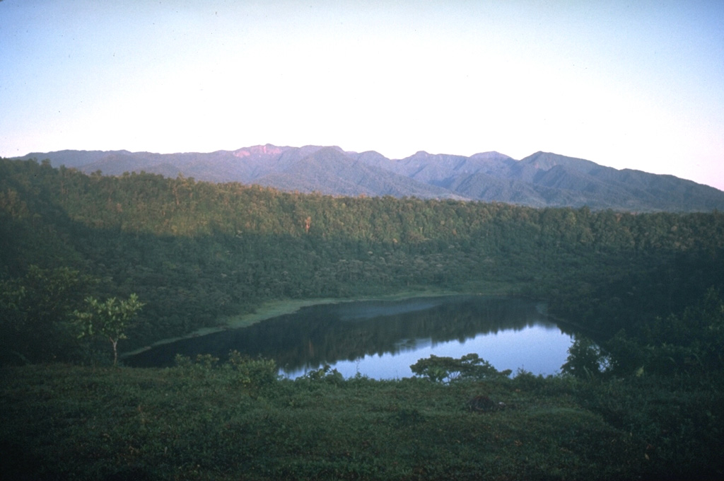
 The Platanar volcanic complex on the horizon is the NW-most volcano in the Cordillera Central of Costa Rica. The complex consists of Platanar and Porvenir, which formed within the Chocosuela caldera. This view is from the east with the Hule maar, located about 11 km north of the Poás summit, in the foreground.
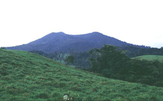 Platanar volcano is within of the Juan Castro Blanco National Park, located NW of the more well-known Poás volcano. Volcán Platanar and Volcán Porvenir were constructed along a N-S line in the western part of the park within Chocosuela caldera, which formed as a result of major explosive eruptions during the late Pleistocene.
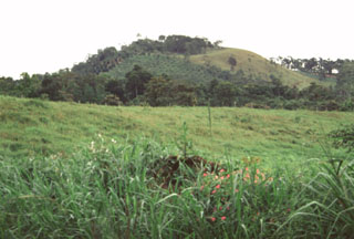 The Aguas Zarcas group of nine basaltic scoria cones is located on the northern flank of the Platanar-Porvenir complex. These cones lie 10-17 km behind the volcanic front of Costa Rica.
 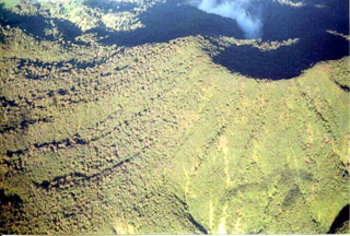 The Platanar summit crater is to the upper right of this photo taken from the south. Holocene lava flows are on the western flank.
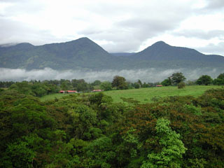 Volcán Platanar rises above farmlands to the north. The summit is also known as Cerro Congo after the howler monkeys occupying its slopes. It lies about 8 km SE of the city of Quesada at the northern end of the Palmira-Chocosuela-Platanar volcanic complex.
 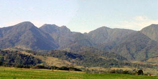 The Viejo-Porvenir complex is seen here rising above farmlands NE of the massif. The Viejo peak is on the left and Porvenir on the right.
The following 25 samples associated with this volcano can be found in the Smithsonian's NMNH Department of Mineral Sciences collections, and may be availble for research (contact the Rock and Ore Collections Manager). Catalog number links will open a window with more information.
| Catalog Number | Sample Description | Lava Source | Collection Date |
|---|---|---|---|
| NMNH 116066-399 | Tephra | -- | 23 Apr 1985 |
| NMNH 116066-401 | Tephra | -- | 23 Apr 1985 |
| NMNH 116066-403 | Tephra | -- | 23 Apr 1985 |
| NMNH 116066-405 | Tephra | -- | 23 Apr 1985 |
| NMNH 116066-408 | Augite-Hypersthene Andesite | -- | 23 Apr 1985 |
| NMNH 116066-410 | Tephra | -- | 23 Apr 1985 |
| NMNH 116066-411 | Tephra | -- | 23 Apr 1985 |
| NMNH 116066-412 | Tephra | -- | 23 Apr 1985 |
| NMNH 116066-413 | Tephra | -- | 23 Apr 1985 |
| NMNH 116066-414 | Tephra | -- | 23 Apr 1985 |
| NMNH 116066-467 | Tephra | -- | 1 May 1985 |
| NMNH 116066-468 | Tephra | -- | 1 May 1985 |
| NMNH 116066-469 | Tephra | -- | 1 May 1985 |
| NMNH 116066-471 | Tephra | -- | 1 May 1985 |
| NMNH 116066-473 | Tephra | -- | 1 May 1985 |
| NMNH 116066-474 | Tephra | -- | 1 May 1985 |
| NMNH 116066-475 | Tephra | -- | 1 May 1985 |
| NMNH 116066-476 | Tephra | -- | 1 May 1985 |
| NMNH 116066-477 | Altered Volcanic Rock | -- | 1 May 1985 |
| NMNH 116066-478 | Volcanic Rock | -- | 1 May 1985 |
| NMNH 116066-479 | Tephra | -- | 1 May 1985 |
| NMNH 116066-480 | Lapilli | -- | 1 May 1985 |
| NMNH 116066-481 | Pumice | -- | 1 May 1985 |
| NMNH 116066-482 | Tephra | -- | 1 May 1985 |
| NMNH 116066-483 | Tephra | -- | 1 May 1985 |
| Copernicus Browser | The Copernicus Browser replaced the Sentinel Hub Playground browser in 2023, to provide access to Earth observation archives from the Copernicus Data Space Ecosystem, the main distribution platform for data from the EU Copernicus missions. |
| MIROVA | Middle InfraRed Observation of Volcanic Activity (MIROVA) is a near real time volcanic hot-spot detection system based on the analysis of MODIS (Moderate Resolution Imaging Spectroradiometer) data. In particular, MIROVA uses the Middle InfraRed Radiation (MIR), measured over target volcanoes, in order to detect, locate and measure the heat radiation sourced from volcanic activity. |
| MODVOLC Thermal Alerts | Using infrared satellite Moderate Resolution Imaging Spectroradiometer (MODIS) data, scientists at the Hawai'i Institute of Geophysics and Planetology, University of Hawai'i, developed an automated system called MODVOLC to map thermal hot-spots in near real time. For each MODIS image, the algorithm automatically scans each 1 km pixel within it to check for high-temperature hot-spots. When one is found the date, time, location, and intensity are recorded. MODIS looks at every square km of the Earth every 48 hours, once during the day and once during the night, and the presence of two MODIS sensors in space allows at least four hot-spot observations every two days. Each day updated global maps are compiled to display the locations of all hot spots detected in the previous 24 hours. There is a drop-down list with volcano names which allow users to 'zoom-in' and examine the distribution of hot-spots at a variety of spatial scales. |
|
WOVOdat
Single Volcano View Temporal Evolution of Unrest Side by Side Volcanoes |
WOVOdat is a database of volcanic unrest; instrumentally and visually recorded changes in seismicity, ground deformation, gas emission, and other parameters from their normal baselines. It is sponsored by the World Organization of Volcano Observatories (WOVO) and presently hosted at the Earth Observatory of Singapore.
GVMID Data on Volcano Monitoring Infrastructure The Global Volcano Monitoring Infrastructure Database GVMID, is aimed at documenting and improving capabilities of volcano monitoring from the ground and space. GVMID should provide a snapshot and baseline view of the techniques and instrumentation that are in place at various volcanoes, which can be use by volcano observatories as reference to setup new monitoring system or improving networks at a specific volcano. These data will allow identification of what monitoring gaps exist, which can be then targeted by remote sensing infrastructure and future instrument deployments. |
| Volcanic Hazard Maps | The IAVCEI Commission on Volcanic Hazards and Risk has a Volcanic Hazard Maps database designed to serve as a resource for hazard mappers (or other interested parties) to explore how common issues in hazard map development have been addressed at different volcanoes, in different countries, for different hazards, and for different intended audiences. In addition to the comprehensive, searchable Volcanic Hazard Maps Database, this website contains information about diversity of volcanic hazard maps, illustrated using examples from the database. This site is for educational purposes related to volcanic hazard maps. Hazard maps found on this website should not be used for emergency purposes. For the most recent, official hazard map for a particular volcano, please seek out the proper institutional authorities on the matter. |
| IRIS seismic stations/networks | Incorporated Research Institutions for Seismology (IRIS) Data Services map showing the location of seismic stations from all available networks (permanent or temporary) within a radius of 0.18° (about 20 km at mid-latitudes) from the given location of Platanar. Users can customize a variety of filters and options in the left panel. Note that if there are no stations are known the map will default to show the entire world with a "No data matched request" error notice. |
| UNAVCO GPS/GNSS stations | Geodetic Data Services map from UNAVCO showing the location of GPS/GNSS stations from all available networks (permanent or temporary) within a radius of 20 km from the given location of Platanar. Users can customize the data search based on station or network names, location, and time window. Requires Adobe Flash Player. |
| DECADE Data | The DECADE portal, still in the developmental stage, serves as an example of the proposed interoperability between The Smithsonian Institution's Global Volcanism Program, the Mapping Gas Emissions (MaGa) Database, and the EarthChem Geochemical Portal. The Deep Earth Carbon Degassing (DECADE) initiative seeks to use new and established technologies to determine accurate global fluxes of volcanic CO2 to the atmosphere, but installing CO2 monitoring networks on 20 of the world's 150 most actively degassing volcanoes. The group uses related laboratory-based studies (direct gas sampling and analysis, melt inclusions) to provide new data for direct degassing of deep earth carbon to the atmosphere. |
| Large Eruptions of Platanar | Information about large Quaternary eruptions (VEI >= 4) is cataloged in the Large Magnitude Explosive Volcanic Eruptions (LaMEVE) database of the Volcano Global Risk Identification and Analysis Project (VOGRIPA). |
| EarthChem | EarthChem develops and maintains databases, software, and services that support the preservation, discovery, access and analysis of geochemical data, and facilitate their integration with the broad array of other available earth science parameters. EarthChem is operated by a joint team of disciplinary scientists, data scientists, data managers and information technology developers who are part of the NSF-funded data facility Integrated Earth Data Applications (IEDA). IEDA is a collaborative effort of EarthChem and the Marine Geoscience Data System (MGDS). |

