
The Global Volcanism Program has no activity reports available for Tisingal.
The Global Volcanism Program has no Weekly Reports available for Tisingal.
The Global Volcanism Program has no Bulletin Reports available for Tisingal.
|
|
||||||||||||||||||
The Global Volcanism Program is not aware of any Holocene eruptions from Tisingal. If this volcano has had large eruptions (VEI >= 4) prior to 12,000 years ago, information might be found on the Tisingal page in the LaMEVE (Large Magnitude Explosive Volcanic Eruptions) database, a part of the Volcano Global Risk Identification and Analysis Project (VOGRIPA).
This compilation of synonyms and subsidiary features may not be comprehensive. Features are organized into four major categories: Cones, Craters, Domes, and Thermal Features. Synonyms of features appear indented below the primary name. In some cases additional feature type, elevation, or location details are provided.
Synonyms |
||||
| Colorado | Pecón, Cerro | ||||
Domes |
||||
| Feature Name | Feature Type | Elevation | Latitude | Longitude |
| Pando, Cerro
Silla de Pando, Cerro |
Dome | 1756 m | 8° 49' 12.00" N | 82° 41' 33.00" W |
| Pelón, Cerro | Dome | 2679 m | 8° 53' 0.00" N | 82° 39' 31.00" W |
| Totuma, Cerro | Dome | 2625 m | 8° 53' 45.00" N | 82° 40' 40.00" W |
 The Volcán Barú summit lava dome complex is seen here from the SE. The road to the right leads to communication towers at the summit. The ridge extending across the photo beyond the domes is the northern headwall of a large horseshoe-shaped collapse scarp.
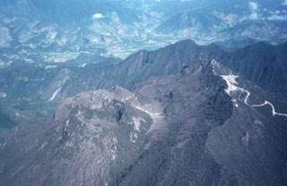
 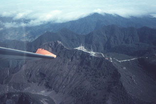 The summit of Barú volcano is just above the wing tip in this view from the SE. Communication towers line the ridge to the right of the summit. Behind it is the northern wall of a large horseshoe-shaped collapse scarp. The Pleistocene Volcán Colorado is under clouds to the upper right.
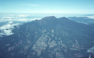 This photo shows Volcán Barú from the ESE. The summit lava dome complex appears beyond the back wall of a large collapse scarp that forms an irregular ridge near the summit. The flat-topped edifice beyond Barú to the right (NW) is the Pleistocene Volcán Colorado.
  The irregular, hummocky terrain extending to the SW toward the Pacific coastal plain is part of a massive debris-avalanche deposit that originated from edifice collapse of Volcán Tisingal. This view is from Cerro Pando, a satellitic lava dome south of Volcán Colorado. Both volcanoes of the Barú-Colorado complex underwent edifice failure, producing voluminous debris-avalanche deposits that form a broad blanket reaching beyond the Panamerican highway to the Pacific coastal plain.
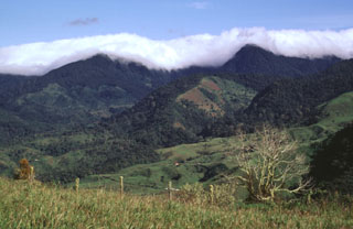 Clouds drape Cerro Totuma (left) and Cerro Pelón (right), post-caldera lava domes of Volcán Tsingal (Cerro Colorado). The volcano lies in the Talamanca Range of westernmost Panama, next to the Costa Rica border NW of Volcán Barú. The photo is taken from Cerro Pando, a lava dome that lies on the southern side of the volcano, opposite a 7-km-wide caldera that is breached widely to the SW. Potassium-Argon ages for the Volcán Colorado complex range from 1.66 million years to 0.52 million years.
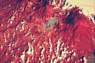 This false-color Landsat image shows two large Quaternary volcanoes in western Panamá. Barú volcano is at the upper right below the cloud cover, and Volcán Colorado lies at the top center. Virtually the entire lower left quadrant of the image is underlain by debris avalanche deposits produced by collapse of these two volcanoes, which left large scarps opening widely towards the W and SW. The light-colored area west of Barú consists of pyroclastic flow and lahar deposits related to lava dome growth.
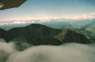 Two post-caldera lava domes of Volcán Colorado are seen here from the NE. The forested dacitic 2679-m-high Cerro Pelón lava dome is at the left center and andesitic 2625-m-high Cerro Totuma is the lava dome at the right. Roughly 1400-year-old tephra deposits on top of Cerro Totuma originated from Volcán Barú. The northern caldera rim can be seen just above the cloud layer, in front and to the left of Cerro Totuma. The caldera is breached widely to the SW, in the direction of Costa Rica in the background.
There are no samples for Tisingal in the Smithsonian's NMNH Department of Mineral Sciences Rock and Ore collection.
| Copernicus Browser | The Copernicus Browser replaced the Sentinel Hub Playground browser in 2023, to provide access to Earth observation archives from the Copernicus Data Space Ecosystem, the main distribution platform for data from the EU Copernicus missions. |
|
WOVOdat
Single Volcano View Temporal Evolution of Unrest Side by Side Volcanoes |
WOVOdat is a database of volcanic unrest; instrumentally and visually recorded changes in seismicity, ground deformation, gas emission, and other parameters from their normal baselines. It is sponsored by the World Organization of Volcano Observatories (WOVO) and presently hosted at the Earth Observatory of Singapore.
GVMID Data on Volcano Monitoring Infrastructure The Global Volcano Monitoring Infrastructure Database GVMID, is aimed at documenting and improving capabilities of volcano monitoring from the ground and space. GVMID should provide a snapshot and baseline view of the techniques and instrumentation that are in place at various volcanoes, which can be use by volcano observatories as reference to setup new monitoring system or improving networks at a specific volcano. These data will allow identification of what monitoring gaps exist, which can be then targeted by remote sensing infrastructure and future instrument deployments. |
| IRIS seismic stations/networks | Incorporated Research Institutions for Seismology (IRIS) Data Services map showing the location of seismic stations from all available networks (permanent or temporary) within a radius of 0.18° (about 20 km at mid-latitudes) from the given location of Tisingal. Users can customize a variety of filters and options in the left panel. Note that if there are no stations are known the map will default to show the entire world with a "No data matched request" error notice. |
| UNAVCO GPS/GNSS stations | Geodetic Data Services map from UNAVCO showing the location of GPS/GNSS stations from all available networks (permanent or temporary) within a radius of 20 km from the given location of Tisingal. Users can customize the data search based on station or network names, location, and time window. Requires Adobe Flash Player. |
| Large Eruptions of Tisingal | Information about large Quaternary eruptions (VEI >= 4) is cataloged in the Large Magnitude Explosive Volcanic Eruptions (LaMEVE) database of the Volcano Global Risk Identification and Analysis Project (VOGRIPA). |
| EarthChem | EarthChem develops and maintains databases, software, and services that support the preservation, discovery, access and analysis of geochemical data, and facilitate their integration with the broad array of other available earth science parameters. EarthChem is operated by a joint team of disciplinary scientists, data scientists, data managers and information technology developers who are part of the NSF-funded data facility Integrated Earth Data Applications (IEDA). IEDA is a collaborative effort of EarthChem and the Marine Geoscience Data System (MGDS). |

