
A summit block crashing into the caldera lake on 13 October triggers a deadly debris flow
This report is based on field work conducted at Altar during 23-25 October. At 0558 on 13 October a large block of andesitic breccia with a volume of ~1.5 x 10⁶ m3 broke from the N wall of La Monja Grande (The Great Nun), a snow- and ice-covered peak near the summit of the Plio-Pleistocene stratovolcano Altar. The catastrophic fall was likely facilitated by frost wedging that slowly developed and enlarged fractures throughout the rock. The block fell 900 m and landed in the E end of Laguna Amarilla (Yellow Lagoon) within the summit caldera. The impact to the lake generated an initial wave 50 m in height and smaller successive waves that ejected 1.5-3.0 x 10⁶ m3 of water and sent it hurtling down the W side of the mountain.
The water eroded the slope along its path and picked up glacial moraine material, mud, and large blocks, becoming a debris flow. The flow advanced swiftly into the valley of Collanes, collecting more sediment as it progressed. Blocks up to 7 m in diameter were deposited 300 m from the caldera, and 1-m-diameter blocks dropped out at a distance of 1,500 m. The bottom of the valley, at an elevation of 3,950 m, was coated with mud to a height of 20 m. In less than 2 minutes, the flow reached a narrow section near the end of the valley, causing an increase in velocity. The flow destroyed three of four houses located in the Able Urco community, and swept away livestock, including 80 cows and 23 horses. The flow reached the Blanco River and eroded the banks of this section up to 30 m in height. Thirteen people were killed by the oncoming flow before it reached the Chambo River, where the valley widens. This caused a decrease in flow velocity and deposition of material in an alluvial fan. The fan managed to partially dam the river, temporarily creating a lagoon of 1.5 km in length.
Information Contacts: Minard Hall (IG-EPN); Bernardo Beate (IG-EPN); Jean-Philippe Eissen (IG-EPN, IRD); Bernard Francou (IRD, INAMHI), and Bolivar Cáceres (INAMHI): Instituto Geofísico, Escuela Politécnica Nacional (IG-EPN), Apartado 17-01-2759, Quito, Ecuador (URL: http://www.igepn.edu.ec/); Instituto Nacional Meteorología e Hidrología (INAMHI), Iñaquito 700 y Corea, Quito-Ecuador 16-310 (URL: http://www.inamhi.gov.ec/); Institut de Recherche pour le Développement (IRD) (URL: http://www.ird.fr/fr/).
The Global Volcanism Program has no Weekly Reports available for Altar.
Reports are organized chronologically and indexed below by Month/Year (Publication Volume:Number), and include a one-line summary. Click on the index link or scroll down to read the reports.
A summit block crashing into the caldera lake on 13 October triggers a deadly debris flow
This report is based on field work conducted at Altar during 23-25 October. At 0558 on 13 October a large block of andesitic breccia with a volume of ~1.5 x 10⁶ m3 broke from the N wall of La Monja Grande (The Great Nun), a snow- and ice-covered peak near the summit of the Plio-Pleistocene stratovolcano Altar. The catastrophic fall was likely facilitated by frost wedging that slowly developed and enlarged fractures throughout the rock. The block fell 900 m and landed in the E end of Laguna Amarilla (Yellow Lagoon) within the summit caldera. The impact to the lake generated an initial wave 50 m in height and smaller successive waves that ejected 1.5-3.0 x 10⁶ m3 of water and sent it hurtling down the W side of the mountain.
The water eroded the slope along its path and picked up glacial moraine material, mud, and large blocks, becoming a debris flow. The flow advanced swiftly into the valley of Collanes, collecting more sediment as it progressed. Blocks up to 7 m in diameter were deposited 300 m from the caldera, and 1-m-diameter blocks dropped out at a distance of 1,500 m. The bottom of the valley, at an elevation of 3,950 m, was coated with mud to a height of 20 m. In less than 2 minutes, the flow reached a narrow section near the end of the valley, causing an increase in velocity. The flow destroyed three of four houses located in the Able Urco community, and swept away livestock, including 80 cows and 23 horses. The flow reached the Blanco River and eroded the banks of this section up to 30 m in height. Thirteen people were killed by the oncoming flow before it reached the Chambo River, where the valley widens. This caused a decrease in flow velocity and deposition of material in an alluvial fan. The fan managed to partially dam the river, temporarily creating a lagoon of 1.5 km in length.
Information Contacts: Minard Hall (IG-EPN); Bernardo Beate (IG-EPN); Jean-Philippe Eissen (IG-EPN, IRD); Bernard Francou (IRD, INAMHI), and Bolivar Cáceres (INAMHI): Instituto Geofísico, Escuela Politécnica Nacional (IG-EPN), Apartado 17-01-2759, Quito, Ecuador (URL: http://www.igepn.edu.ec/); Instituto Nacional Meteorología e Hidrología (INAMHI), Iñaquito 700 y Corea, Quito-Ecuador 16-310 (URL: http://www.inamhi.gov.ec/); Institut de Recherche pour le Développement (IRD) (URL: http://www.ird.fr/fr/).
|
|
||||||||||||||||||
The Global Volcanism Program is not aware of any Holocene eruptions from Altar. If this volcano has had large eruptions (VEI >= 4) prior to 12,000 years ago, information might be found on the Altar page in the LaMEVE (Large Magnitude Explosive Volcanic Eruptions) database, a part of the Volcano Global Risk Identification and Analysis Project (VOGRIPA).
This compilation of synonyms and subsidiary features may not be comprehensive. Features are organized into four major categories: Cones, Craters, Domes, and Thermal Features. Synonyms of features appear indented below the primary name. In some cases additional feature type, elevation, or location details are provided.
Synonyms |
| Capac Urcu | Collanes |
There are no samples for Altar in the Smithsonian's NMNH Department of Mineral Sciences Rock and Ore collection.
| Copernicus Browser | The Copernicus Browser replaced the Sentinel Hub Playground browser in 2023, to provide access to Earth observation archives from the Copernicus Data Space Ecosystem, the main distribution platform for data from the EU Copernicus missions. |
|
WOVOdat
Single Volcano View Temporal Evolution of Unrest Side by Side Volcanoes |
WOVOdat is a database of volcanic unrest; instrumentally and visually recorded changes in seismicity, ground deformation, gas emission, and other parameters from their normal baselines. It is sponsored by the World Organization of Volcano Observatories (WOVO) and presently hosted at the Earth Observatory of Singapore.
GVMID Data on Volcano Monitoring Infrastructure The Global Volcano Monitoring Infrastructure Database GVMID, is aimed at documenting and improving capabilities of volcano monitoring from the ground and space. GVMID should provide a snapshot and baseline view of the techniques and instrumentation that are in place at various volcanoes, which can be use by volcano observatories as reference to setup new monitoring system or improving networks at a specific volcano. These data will allow identification of what monitoring gaps exist, which can be then targeted by remote sensing infrastructure and future instrument deployments. |
| IRIS seismic stations/networks | Incorporated Research Institutions for Seismology (IRIS) Data Services map showing the location of seismic stations from all available networks (permanent or temporary) within a radius of 0.18° (about 20 km at mid-latitudes) from the given location of Altar. Users can customize a variety of filters and options in the left panel. Note that if there are no stations are known the map will default to show the entire world with a "No data matched request" error notice. |
| UNAVCO GPS/GNSS stations | Geodetic Data Services map from UNAVCO showing the location of GPS/GNSS stations from all available networks (permanent or temporary) within a radius of 20 km from the given location of Altar. Users can customize the data search based on station or network names, location, and time window. Requires Adobe Flash Player. |
| Large Eruptions of Altar | Information about large Quaternary eruptions (VEI >= 4) is cataloged in the Large Magnitude Explosive Volcanic Eruptions (LaMEVE) database of the Volcano Global Risk Identification and Analysis Project (VOGRIPA). |
| EarthChem | EarthChem develops and maintains databases, software, and services that support the preservation, discovery, access and analysis of geochemical data, and facilitate their integration with the broad array of other available earth science parameters. EarthChem is operated by a joint team of disciplinary scientists, data scientists, data managers and information technology developers who are part of the NSF-funded data facility Integrated Earth Data Applications (IEDA). IEDA is a collaborative effort of EarthChem and the Marine Geoscience Data System (MGDS). |


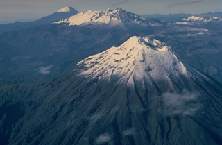 This aerial view looking SSE down Ecuador's Cordillera Real mountain range shows three 5000-m-high stratovolcanoes that have undergone varying degrees of erosion. Tungurahua volcano in the foreground rises more than 3000 m above its northern base and has produced some of Ecuador's most powerful explosive eruptions during historical time. Altar (center) is an extensively eroded volcano of Pleistocene age. Symmetrical, undissected Sangay volcano in the background is Ecuador's most active and has been in continuous eruption since 1934.