The Global Volcanism Program has no activity reports available for Santiago.
The Global Volcanism Program has no Weekly Reports available for Santiago.
The Global Volcanism Program has no Bulletin Reports available for Santiago.
|
|
||||||||||||||||||||||||||||
There is data available for 3 confirmed eruptive periods.
1904 - 1906 Dec 15 ± 45 days Confirmed Eruption (Explosive / Effusive) VEI: 0
| Episode 1 | Eruption (Explosive / Effusive) | SE flank | |||||||||||||||||||||||
|---|---|---|---|---|---|---|---|---|---|---|---|---|---|---|---|---|---|---|---|---|---|---|---|---|
| 1904 - 1906 Dec 15 ± 45 days | Evidence from Observations: Reported | |||||||||||||||||||||||
|
List of 3 Events for Episode 1 at SE flank
|
||||||||||||||||||||||||
1897 Confirmed Eruption (Explosive / Effusive) VEI: 0
| Episode 1 | Eruption (Explosive / Effusive) | SE flank (Sullivan Bay?) | ||||||||||||||||||
|---|---|---|---|---|---|---|---|---|---|---|---|---|---|---|---|---|---|---|---|
| 1897 - Unknown | Evidence from Observations: Reported | ||||||||||||||||||
|
List of 2 Events for Episode 1 at SE flank (Sullivan Bay?)
|
|||||||||||||||||||
1759 ± 75 years Confirmed Eruption (Explosive / Effusive)
| Episode 1 | Eruption (Explosive / Effusive) | West flank (James Bay) | ||||||||||||||||||
|---|---|---|---|---|---|---|---|---|---|---|---|---|---|---|---|---|---|---|---|
| 1759 ± 75 years - Unknown | Evidence from Correlation: Anthropology | ||||||||||||||||||
|
List of 2 Events for Episode 1 at West flank (James Bay)
|
|||||||||||||||||||
This compilation of synonyms and subsidiary features may not be comprehensive. Features are organized into four major categories: Cones, Craters, Domes, and Thermal Features. Synonyms of features appear indented below the primary name. In some cases additional feature type, elevation, or location details are provided.
Synonyms |
||||
| San Salvador | James | Olmedo | Gil | York | ||||
Cones |
||||
| Feature Name | Feature Type | Elevation | Latitude | Longitude |
| Albany Island | Cone | 0° 10' 0.00" S | 90° 51' 0.00" W | |
| Cabo Cowan | Tuff cone | 284 m | 0° 11' 0.00" S | 90° 50' 0.00" W |
| Inn, Cerro | Cone | 0° 17' 0.00" S | 90° 34' 0.00" W | |
Craters |
||||
| Feature Name | Feature Type | Elevation | Latitude | Longitude |
| Bartholomew Island | Crater | 109 m | 0° 17' 0.00" S | 90° 33' 0.00" W |
| Salt Lake | Crater | 0° 14' 0.00" S | 90° 50' 0.00" W | |
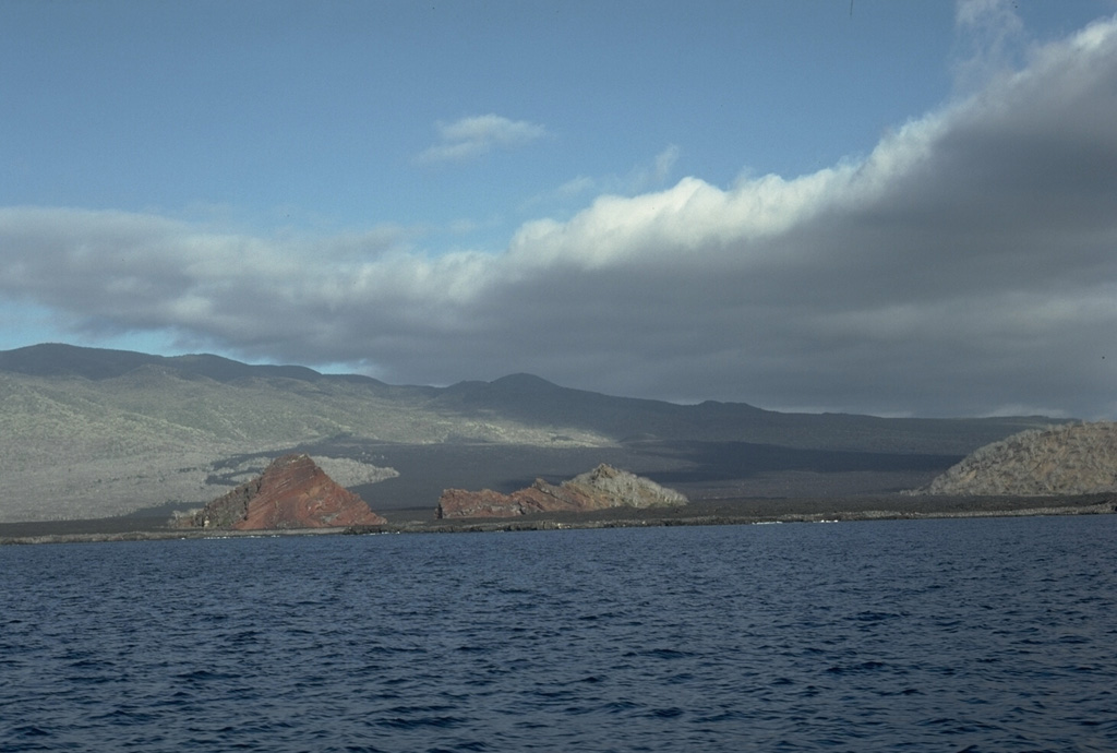
 A spectacular suite of volcanic features flanks Sullivan Bay, at the eastern end of Santiago Island. This view looks NE across the bay to Bartolomé Island. The sharp pinnacle at the left, a remnant of an eroded tuff cone, is one of the many scenic highlights of the Galápagos Islands. Bartolomé Island contains eroded tuff cones, a dissected solidified lava lake, and a youthful lava plateau. The flat coastline of Santiago Island in the foreground is formed from a vast field of youthful pahoehoe lava flows that wraps around the SE corner of the island.
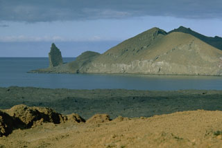
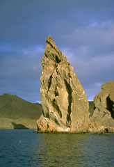 This prominent pinnacle is an eroded remnant of a tuff cone on Bartolomé Island, off the east coast of Santiago Island. A wide variety of volcanic features flanks Sullivan Bay, one of the most visited boat anchorages in the Galápagos Islands. These include tuff cones and cinder cones, a dissected solidifed lava lake, and vast fields of youthful pahoehoe lava flows.
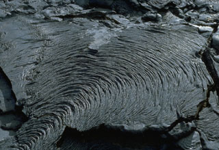 The ropy texture of pahoehoe lava flows is produced when the thin solidifying surface of the flow is pushed by the advancing, still-molten interior. This pleated pahoehoe lobe, on a lava flow at Santiago shield volcano in the Galápagos Islands, advanced slowly from the bottom left to the top right. Pahoehoe lavas are the least viscous of common lava types, and thus form diverse surface structures.
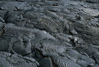 An extensive field of spectacular pahoehoe lava flows is located near Sullivan Bay on Santiago Island. The fresh, sparsely vegetated flows cover an area of more than 50 km2 along the SE coast of the island. Eruptions occurred at SE Santiago in 1897 and 1904-06. A small lava shield 3.5 km inland from Cabo Trenton on the SE tip of the island was the principal vent of these flows.
 The elongated shield volcano of Santiago Island is dotted with Holocene pyroclastic cones. Fresh lava flows that blanket the flanks of the volcano originated from these cones. The 920-m-high summit ridge, lined with NW-trending cinder and spatter cones, is seen here from James Bay on the west side of the island. The James Bay lava flows (center) reached the coast along a broad front. They were dated by fragments of marmalade pots left by buccaneers in 1684 that were subsequently embedded in the lava flows observed by Charles Darwin in 1835.
 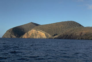 Cabo Cowan is a tuff cone at the NW tip of Santiago Island in the Galápagos Islands. Wave erosion has truncated the flanks of the cone, forming vertical sea cliffs that expose its interior stratigraphy. The cone is located where the NW-trending rift zone along the crest of Santiago shield volcano encounters the sea.
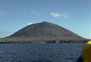 An unnamed 394-m-high cinder cone is a prominent landmark near James Bay at the western end of Santiago Island. The eruptions that constructed the cone were initially submarine, producing palagonitic tuffs. As the cone grew above sea level, subaerial explosions produced basaltic scoria that forms the upper part of the cone. A similar, but smaller cone lies immediately to the SE, out of view to the right.
The following 4 samples associated with this volcano can be found in the Smithsonian's NMNH Department of Mineral Sciences collections, and may be availble for research (contact the Rock and Ore Collections Manager). Catalog number links will open a window with more information.
| Catalog Number | Sample Description | Lava Source | Collection Date |
|---|---|---|---|
| NMNH 118118-1 | Basalt | -- | 4 Jul 1970 |
| NMNH 118118-2 | Basalt | -- | -- |
| NMNH 118118-3 | Basalt | -- | -- |
| NMNH 118118-4 | Basalt | -- | -- |
| Copernicus Browser | The Copernicus Browser replaced the Sentinel Hub Playground browser in 2023, to provide access to Earth observation archives from the Copernicus Data Space Ecosystem, the main distribution platform for data from the EU Copernicus missions. |
| MIROVA | Middle InfraRed Observation of Volcanic Activity (MIROVA) is a near real time volcanic hot-spot detection system based on the analysis of MODIS (Moderate Resolution Imaging Spectroradiometer) data. In particular, MIROVA uses the Middle InfraRed Radiation (MIR), measured over target volcanoes, in order to detect, locate and measure the heat radiation sourced from volcanic activity. |
| MODVOLC Thermal Alerts | Using infrared satellite Moderate Resolution Imaging Spectroradiometer (MODIS) data, scientists at the Hawai'i Institute of Geophysics and Planetology, University of Hawai'i, developed an automated system called MODVOLC to map thermal hot-spots in near real time. For each MODIS image, the algorithm automatically scans each 1 km pixel within it to check for high-temperature hot-spots. When one is found the date, time, location, and intensity are recorded. MODIS looks at every square km of the Earth every 48 hours, once during the day and once during the night, and the presence of two MODIS sensors in space allows at least four hot-spot observations every two days. Each day updated global maps are compiled to display the locations of all hot spots detected in the previous 24 hours. There is a drop-down list with volcano names which allow users to 'zoom-in' and examine the distribution of hot-spots at a variety of spatial scales. |
|
WOVOdat
Single Volcano View Temporal Evolution of Unrest Side by Side Volcanoes |
WOVOdat is a database of volcanic unrest; instrumentally and visually recorded changes in seismicity, ground deformation, gas emission, and other parameters from their normal baselines. It is sponsored by the World Organization of Volcano Observatories (WOVO) and presently hosted at the Earth Observatory of Singapore.
GVMID Data on Volcano Monitoring Infrastructure The Global Volcano Monitoring Infrastructure Database GVMID, is aimed at documenting and improving capabilities of volcano monitoring from the ground and space. GVMID should provide a snapshot and baseline view of the techniques and instrumentation that are in place at various volcanoes, which can be use by volcano observatories as reference to setup new monitoring system or improving networks at a specific volcano. These data will allow identification of what monitoring gaps exist, which can be then targeted by remote sensing infrastructure and future instrument deployments. |
| Volcanic Hazard Maps | The IAVCEI Commission on Volcanic Hazards and Risk has a Volcanic Hazard Maps database designed to serve as a resource for hazard mappers (or other interested parties) to explore how common issues in hazard map development have been addressed at different volcanoes, in different countries, for different hazards, and for different intended audiences. In addition to the comprehensive, searchable Volcanic Hazard Maps Database, this website contains information about diversity of volcanic hazard maps, illustrated using examples from the database. This site is for educational purposes related to volcanic hazard maps. Hazard maps found on this website should not be used for emergency purposes. For the most recent, official hazard map for a particular volcano, please seek out the proper institutional authorities on the matter. |
| IRIS seismic stations/networks | Incorporated Research Institutions for Seismology (IRIS) Data Services map showing the location of seismic stations from all available networks (permanent or temporary) within a radius of 0.18° (about 20 km at mid-latitudes) from the given location of Santiago. Users can customize a variety of filters and options in the left panel. Note that if there are no stations are known the map will default to show the entire world with a "No data matched request" error notice. |
| UNAVCO GPS/GNSS stations | Geodetic Data Services map from UNAVCO showing the location of GPS/GNSS stations from all available networks (permanent or temporary) within a radius of 20 km from the given location of Santiago. Users can customize the data search based on station or network names, location, and time window. Requires Adobe Flash Player. |
| DECADE Data | The DECADE portal, still in the developmental stage, serves as an example of the proposed interoperability between The Smithsonian Institution's Global Volcanism Program, the Mapping Gas Emissions (MaGa) Database, and the EarthChem Geochemical Portal. The Deep Earth Carbon Degassing (DECADE) initiative seeks to use new and established technologies to determine accurate global fluxes of volcanic CO2 to the atmosphere, but installing CO2 monitoring networks on 20 of the world's 150 most actively degassing volcanoes. The group uses related laboratory-based studies (direct gas sampling and analysis, melt inclusions) to provide new data for direct degassing of deep earth carbon to the atmosphere. |
| Large Eruptions of Santiago | Information about large Quaternary eruptions (VEI >= 4) is cataloged in the Large Magnitude Explosive Volcanic Eruptions (LaMEVE) database of the Volcano Global Risk Identification and Analysis Project (VOGRIPA). |
| EarthChem | EarthChem develops and maintains databases, software, and services that support the preservation, discovery, access and analysis of geochemical data, and facilitate their integration with the broad array of other available earth science parameters. EarthChem is operated by a joint team of disciplinary scientists, data scientists, data managers and information technology developers who are part of the NSF-funded data facility Integrated Earth Data Applications (IEDA). IEDA is a collaborative effort of EarthChem and the Marine Geoscience Data System (MGDS). |

