The Global Volcanism Program has no activity reports available for Chachani Volcanic Complex.
The Global Volcanism Program has no Weekly Reports available for Chachani Volcanic Complex.
The Global Volcanism Program has no Bulletin Reports available for Chachani Volcanic Complex.
|
|
||||||||||||||||||||||||||
The Global Volcanism Program is not aware of any Holocene eruptions from Chachani Volcanic Complex. If this volcano has had large eruptions (VEI >= 4) prior to 12,000 years ago, information might be found on the Chachani Volcanic Complex page in the LaMEVE (Large Magnitude Explosive Volcanic Eruptions) database, a part of the Volcano Global Risk Identification and Analysis Project (VOGRIPA).
This compilation of synonyms and subsidiary features may not be comprehensive. Features are organized into four major categories: Cones, Craters, Domes, and Thermal Features. Synonyms of features appear indented below the primary name. In some cases additional feature type, elevation, or location details are provided.
Synonyms |
||||
| Chanchani | Cachani | ||||
Cones |
||||
| Feature Name | Feature Type | Elevation | Latitude | Longitude |
| Andes, Cerro los | Cone | 3650 m | 16° 17' 0.00" S | 71° 36' 0.00" W |
| Cabreria, Cerro | Cone | 4308 m | 16° 14' 44.00" S | 71° 30' 59.00" W |
| Chachani, Nevado | Stratovolcano | 6059 m | 16° 11' 38.00" S | 71° 31' 55.00" W |
| Horqueta, Cerro | Cone | 5484 m | 16° 11' 46.00" S | 71° 33' 58.00" W |
| Pampa de Palacio
Cortaderas, Las |
Shield volcano | 3862 m | 16° 15' 0.00" S | 71° 36' 0.00" W |
| Volcancillo, Cerro el | Cone | 5180 m | 16° 9' 40.00" S | 71° 31' 8.00" W |
Craters |
||||
| Feature Name | Feature Type | Elevation | Latitude | Longitude |
| Cortaderal, Cerro el | Fissure vent | 3680 m | 16° 15' 0.00" S | 71° 35' 0.00" W |
Domes |
||||
| Feature Name | Feature Type | Elevation | Latitude | Longitude |
| Chingana, Cerro la | Dome | 5500 m | 16° 8' 31.00" S | 71° 30' 47.00" W |
| Nocarane, Cerro
Frailes, Los |
Dome | 5784 m | 16° 7' 41.00" S | 71° 32' 13.00" W |
| Penones, Cerro los | Dome | |||
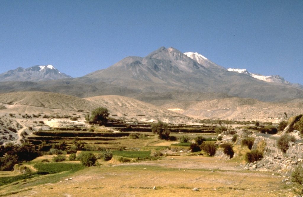
 The Chachani Volcanic Complex, seen here from the SW near the village of Yura, consists of a large cluster of Pleistocene volcanic features. This view shows Cerro Nocarane (left distance), El Rodado (center foreground), La Horqueta (center high peak), Nevado Chachani (center right, snow covered), and Estribo (right).
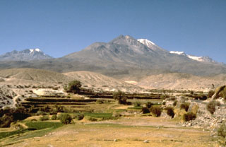
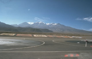 Seen here looking N from the international airport at Arequipa, Perú, multiple edifices of the massive Chachani Volcanic Complex extend ~9 km across the horizon, with Nevado Chachani in the center. The dark hills in the left-center foreground are lava domes and flows on the SW flank of the main complex dated to about 350-400 ka.
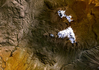 The Chachani Volcanic Complex lies immediately north of the city of Arequipa, Perú, seen here in a NASA Landsat image (N is at top). This large cluster of volcanic features includes the snow-covered Nocarane (top center) and Chingana (top right) peaks, the central group (left to right) of El Rodado, La Horqueta, Chachani, Angel, and Estribo (top), and the Airport-Potrero lava domes and flows (bottom center).
There are no samples for Chachani Volcanic Complex in the Smithsonian's NMNH Department of Mineral Sciences Rock and Ore collection.
| Copernicus Browser | The Copernicus Browser replaced the Sentinel Hub Playground browser in 2023, to provide access to Earth observation archives from the Copernicus Data Space Ecosystem, the main distribution platform for data from the EU Copernicus missions. |
|
WOVOdat
Single Volcano View Temporal Evolution of Unrest Side by Side Volcanoes |
WOVOdat is a database of volcanic unrest; instrumentally and visually recorded changes in seismicity, ground deformation, gas emission, and other parameters from their normal baselines. It is sponsored by the World Organization of Volcano Observatories (WOVO) and presently hosted at the Earth Observatory of Singapore.
GVMID Data on Volcano Monitoring Infrastructure The Global Volcano Monitoring Infrastructure Database GVMID, is aimed at documenting and improving capabilities of volcano monitoring from the ground and space. GVMID should provide a snapshot and baseline view of the techniques and instrumentation that are in place at various volcanoes, which can be use by volcano observatories as reference to setup new monitoring system or improving networks at a specific volcano. These data will allow identification of what monitoring gaps exist, which can be then targeted by remote sensing infrastructure and future instrument deployments. |
| IRIS seismic stations/networks | Incorporated Research Institutions for Seismology (IRIS) Data Services map showing the location of seismic stations from all available networks (permanent or temporary) within a radius of 0.18° (about 20 km at mid-latitudes) from the given location of Chachani Volcanic Complex. Users can customize a variety of filters and options in the left panel. Note that if there are no stations are known the map will default to show the entire world with a "No data matched request" error notice. |
| UNAVCO GPS/GNSS stations | Geodetic Data Services map from UNAVCO showing the location of GPS/GNSS stations from all available networks (permanent or temporary) within a radius of 20 km from the given location of Chachani Volcanic Complex. Users can customize the data search based on station or network names, location, and time window. Requires Adobe Flash Player. |
| Large Eruptions of Chachani Volcanic Complex | Information about large Quaternary eruptions (VEI >= 4) is cataloged in the Large Magnitude Explosive Volcanic Eruptions (LaMEVE) database of the Volcano Global Risk Identification and Analysis Project (VOGRIPA). |
| EarthChem | EarthChem develops and maintains databases, software, and services that support the preservation, discovery, access and analysis of geochemical data, and facilitate their integration with the broad array of other available earth science parameters. EarthChem is operated by a joint team of disciplinary scientists, data scientists, data managers and information technology developers who are part of the NSF-funded data facility Integrated Earth Data Applications (IEDA). IEDA is a collaborative effort of EarthChem and the Marine Geoscience Data System (MGDS). |

