Peru Volcanoes
-

Nevado Chachani
-
Tacora
-
Sabancaya
-

Coropuna
-
Sabancaya
-
Coropuna
-
Sabancaya
-
Sabancaya
-
Nevado Chachani
-
Huaynaputina
-

Tutupaca
-
Ubinas
-
Nevado Chachani
-
Nevado Chachani
-
Huambo
-
Coropuna
-
Coropuna
-
Sabancaya
-
Coropuna
-
Kimsachata-Oroscocha
Peru has 16 Holocene volcanoes. Note that as a scientific organization we provide these listings for informational purposes only, with no international legal or policy implications. Volcanoes will be included on this list if they are within the boundaries of a country, on a shared boundary or area, in a remote territory, or within a maritime Exclusive Economic Zone. Bolded volcanoes have erupted within the past 20 years. Suggestions and data updates are always welcome ().
| Volcano Name | Last Eruption | Volcanic Province | Primary Landform |
|---|---|---|---|
| Andahua-Orcopampa | 1490 CE | Andean Central Volcanic Arc | Cluster |
| Cerro Auquihuato | Unknown - Evidence Uncertain | Andean Central Volcanic Arc | Minor |
| Nevados Casiri | Unknown - Evidence Credible | Andean Central Volcanic Arc | Composite |
| Nevado Chachani | Unknown - Evidence Uncertain | Andean Central Volcanic Arc | Composite |
| Coropuna | Unknown - Evidence Credible | Andean Central Volcanic Arc | Composite |
| Huambo | 700 BCE | Andean Central Volcanic Arc | Cluster |
| Huaynaputina | 1600 CE | Andean Central Volcanic Arc | Composite |
| Kimsachata-Oroscocha | 4450 BCE | Andean Central Volcanic Arc | Minor (Silicic) |
| El Misti | 1985 CE | Andean Central Volcanic Arc | Composite |
| Sabancaya | 2024 CE | Andean Central Volcanic Arc | Composite |
| Sara Sara | Unknown - Evidence Credible | Andean Central Volcanic Arc | Composite |
| Tacora | Unknown - Unrest / Holocene | Andean Central Volcanic Arc | Composite |
| Ticsani | 1800 CE | Andean Central Volcanic Arc | Minor (Silicic) |
| Tutupaca | 1802 CE | Andean Central Volcanic Arc | Composite |
| Ubinas | 2024 CE | Andean Central Volcanic Arc | Composite |
| Yucamane | 1320 BCE | Andean Central Volcanic Arc | Composite |
Chronological listing of known Holocene eruptions (confirmed or uncertain) from volcanoes in Peru. Bolded eruptions indicate continuing activity.
| Volcano Name | Start Date | Stop Date | Certainty | VEI | Evidence |
|---|---|---|---|---|---|
| Ubinas | 2024 May 6 | 2024 Jun 6 (continuing) | Confirmed | Observations: Reported | |
| Ubinas | 2023 Jun 22 | 2023 Dec 15 | Confirmed | 3 | Observations: Reported |
| Ubinas | 2019 Jun 24 | 2019 Sep 12 | Confirmed | 2 | Observations: Reported |
| Sabancaya | 2016 Nov 6 | 2024 Jun 6 (continuing) | Confirmed | 3 | Observations: Reported |
| Ubinas | 2016 Sep 13 | 2017 Mar 2 | Confirmed | 2 | Observations: Reported |
| Sabancaya | 2015 Mar 8 | 2015 Dec 12 | Confirmed | 1 | Observations: Aviation |
| Sabancaya | [2014 Aug 5] | [2014 Dec 27] | Uncertain | ||
| Ubinas | 2013 Sep 1 | 2016 Feb 27 | Confirmed | 2 | Observations: Reported |
| Ubinas | [2010 Jul 18] | [2010 Jul 18] | Uncertain | ||
| Ubinas | 2006 Mar 25 (?) | 2009 Jul 4 (?) | Confirmed | 2 | Observations: Reported |
| Sabancaya | 2003 Jul 30 ± 1 days | 2003 Jul 31 (?) | Confirmed | 2 | Observations: Reported |
| Sabancaya | 2000 Apr 16 (?) ± 15 days | 2000 Oct 29 (in or after) | Confirmed | 2 | Observations: Reported |
| Sabancaya | 1990 May 28 | 1998 Sep 16 (?) ± 15 days | Confirmed | 3 | Observations: Reported |
| Sabancaya | 1988 Jun 22 | 1988 Oct 16 (?) ± 15 days | Confirmed | 1 | Observations: Reported |
| Sabancaya | [1987 Aug 7] | [Unknown] | Uncertain | ||
| Sabancaya | 1986 Dec 16 ± 15 days | Unknown | Confirmed | 1 | Observations: Reported |
| El Misti | 1985 Jul 2 ± 182 days | Unknown | Confirmed | 1 | Observations: Reported |
| Ubinas | 1969 Jun 16 ± 15 days | Unknown | Confirmed | 2 | Observations: Reported |
| Ubinas | 1956 May 16 ± 15 days | 1956 Oct 21 | Confirmed | 2 | Observations: Reported |
| Ubinas | 1951 Jul 23 ± 8 days | Unknown | Confirmed | 2 | Observations: Reported |
| Tacora | [1937 Aug 5] | [Unknown] | Uncertain | ||
| Ubinas | 1937 Jun | Unknown | Confirmed | 2 | Observations: Reported |
| Tacora | [1930] | [Unknown] | Uncertain | ||
| Andahua-Orcopampa | [1913 Mar 6] | [Unknown] | Uncertain | ||
| Ubinas | 1907 | Unknown | Confirmed | 2 | Observations: Reported |
| Ubinas | 1906 Oct | Unknown | Confirmed | 2 | Observations: Reported |
| Tutupaca | [1902 Jun] | [1902 Nov] | Uncertain | ||
| El Misti | [1870 Mar] | [Unknown] | Uncertain | ||
| Ubinas | 1869 Oct | Unknown | Confirmed | 2 | Observations: Reported |
| El Misti | [1869 Sep] | [Unknown] | Uncertain | ||
| Ubinas | 1867 May 24 | 1867 May 28 | Confirmed | 2 | Observations: Reported |
| Ubinas | 1865 | Unknown | Confirmed | 2 | Observations: Reported |
| Tutupaca | [1862 Apr] | [1862 May] | Uncertain | ||
| Ubinas | 1862 | Unknown | Confirmed | 2 | Observations: Reported |
| El Misti | [1831 Aug] | [Unknown] | Uncertain | ||
| El Misti | [1830 Aug] | [Unknown] | Uncertain | ||
| Ubinas | 1830 | Unknown | Confirmed | 2 | Observations: Reported |
| El Misti | [1826 Aug] | [Unknown] | Uncertain | ||
| Ubinas | [1826] | [Unknown] | Uncertain | ||
| Tutupaca | 1802 Mar 20 | 1802 Aug 20 ± 10 days | Confirmed | 4 | Observations: Reported |
| Ticsani | 1800 ± 200 years | Unknown | Confirmed | Correlation: Tephrochronology | |
| El Misti | 1787 Jul 28 | 1787 Oct 10 | Confirmed | 1 | Observations: Reported |
| Tutupaca | 1787 | 1789 | Confirmed | 2 | Observations: Reported |
| El Misti | 1784 Jul 9 | Unknown | Confirmed | 2 | Observations: Reported |
| Sabancaya | 1784 Jul | Unknown | Confirmed | Observations: Reported | |
| Ubinas | 1784 | Unknown | Confirmed | 2 | Observations: Reported |
| Tutupaca | [1780] | [1780] | Uncertain | ||
| Sabancaya | 1750 | Unknown | Confirmed | Observations: Reported | |
| El Misti | 1677 May 2 | Unknown | Confirmed | 2 | Observations: Reported |
| Ubinas | 1677 | Unknown | Confirmed | 3 | Observations: Reported |
| Ubinas | 1667 | Unknown | Confirmed | 3 | Observations: Reported |
| Ubinas | 1662 | Unknown | Confirmed | 3 | Observations: Reported |
| Huaynaputina | 1600 Feb 17 ± 1 days | 1600 Mar 6 (?) | Confirmed | 6 | Observations: Reported |
| Ubinas | [1600] | [Unknown] | Uncertain | ||
| El Misti | [1599] | [Unknown] | Uncertain | ||
| Ubinas | 1550 ± 50 years | Unknown | Confirmed | 3 | Observations: Reported |
| El Misti | [1542] | [Unknown] | Uncertain | ||
| Andahua-Orcopampa | 1490 ± 40 years | Unknown | Confirmed | Isotopic: 14C (uncalibrated) | |
| El Misti | 1454 ± 16 years | Unknown | Confirmed | 2 | Observations: Reported |
| Sabancaya | 1350 ± 150 years | Unknown | Confirmed | Correlation: Tephrochronology | |
| El Misti | 1350 ± 50 years | Unknown | Confirmed | Isotopic: 14C (calibrated) | |
| Ubinas | 1082 ± 82 years | Unknown | Confirmed | 5 | Isotopic: 14C (calibrated) |
| El Misti | 0760 ± 100 years | Unknown | Confirmed | Isotopic: 14C (calibrated) | |
| El Misti | 0090 ± 300 years | Unknown | Confirmed | Isotopic: 14C (calibrated) | |
| El Misti | 0080 BCE ± 75 years | Unknown | Confirmed | 4 | Isotopic: 14C (calibrated) |
| El Misti | 0310 BCE ± 100 years | Unknown | Confirmed | Isotopic: 14C (calibrated) | |
| Huambo | 0700 BCE ± 50 years | Unknown | Confirmed | Isotopic: 14C (uncalibrated) | |
| Andahua-Orcopampa | 0940 BCE ± 100 years | Unknown | Confirmed | Isotopic: 14C (uncalibrated) | |
| Yucamane | 1320 BCE (?) | Unknown | Confirmed | 5 | Isotopic: 14C (uncalibrated) |
| Andahua-Orcopampa | 2110 BCE ± 50 years | Unknown | Confirmed | Isotopic: 14C (uncalibrated) | |
| El Misti | 2230 BCE ± 200 years | Unknown | Confirmed | Isotopic: 14C (calibrated) | |
| Sabancaya | 3490 BCE ± 40 years | Unknown | Confirmed | 0 | Isotopic: 14C (uncalibrated) |
| El Misti | 3510 BCE ± 150 years | Unknown | Confirmed | Isotopic: 14C (calibrated) | |
| El Misti | 4020 BCE ± 200 years | Unknown | Confirmed | Isotopic: 14C (calibrated) | |
| Kimsachata-Oroscocha | 4450 BCE (?) | Unknown | Confirmed | Isotopic: 14C (uncalibrated) | |
| El Misti | 5390 BCE ± 75 years | Unknown | Confirmed | Isotopic: 14C (calibrated) | |
| Sabancaya | 6600 BCE (?) | Unknown | Confirmed | Correlation: Tephrochronology | |
| Ubinas | 6850 BCE ± 150 years | Unknown | Confirmed | Isotopic: 14C (calibrated) | |
| El Misti | 7190 BCE ± 150 years | Unknown | Confirmed | Isotopic: 14C (calibrated) | |
| Huaynaputina | 7750 BCE ± 200 years | Unknown | Confirmed | Isotopic: 14C (uncalibrated) | |
| Ubinas | 8560 BCE ± 300 years | Unknown | Confirmed | Isotopic: 14C (calibrated) |
Peru has 5 Pleistocene volcanoes. Note that as a scientific organization we provide these listings for informational purposes only, with no international legal or policy implications. Volcanoes will be included on this list if they are within the boundaries of a country, on a shared boundary or area, in a remote territory, or within a maritime Exclusive Economic Zone. Suggestions and data updates are always welcome ().
| Volcano Name | Volcanic Province | Primary Volcano Type |
|---|---|---|
| Nevados Firura | Andean Central Volcanic Arc | Composite |
| Huambutillo-Rumicola | Andean Central Volcanic Arc | Unknown |
| Cerros Purupuruni | Andean Central Volcanic Arc | Minor |
| Solimana | Andean Central Volcanic Arc | Composite |
| Yura Volcanic Field | Andean Central Volcanic Arc | Cluster |
There are 33 photos available for volcanoes in Peru.
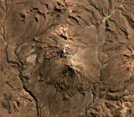
 Huaynaputina is a relatively inconspicuous volcano that was the source of one of the largest historical eruptions of the central Andes in 1600 CE. The volcano has no prominent topographic expression. This view is from the east into a 2.5-km-wide complex caldera that is breached widely to the east. Three ash cones, one of which can be seen in the shadow at the right-center, are located on the floor of the caldera. Light-colored ash deposits from the 1600 eruption can be seen mantling the caldera rim.
 Photo by Oscar González-Ferrán (University of Chile).
 An ash-bearing plume rises above Sabancaya volcano in this photo taken from the NE, possibly in October, 1988. Voluminous steam plumes, some with dark, basal "rooster-tails," were observed to have risen 0.5-1 km above the summit on June 22, 1988. The northern flank of Ampato volcano rises at the far right.
Photo by Minard Hall, 1988 (Escuela National Politecnica, Quito).
 The Río Chillos on the NW side of El Misti volcano has excavated a steep-walled canyon that cuts the lower flanks of the volcano. The NW flank of El Misti is somewhat dissected, in contrast to smoother slopes on other sides. Prevailing winds have distributed a thick ashfall blanket to the NE that mantles the distal margins of youthful lava flows.
 Photo by Norm Banks, 1987 (U.S. Geological Survey).
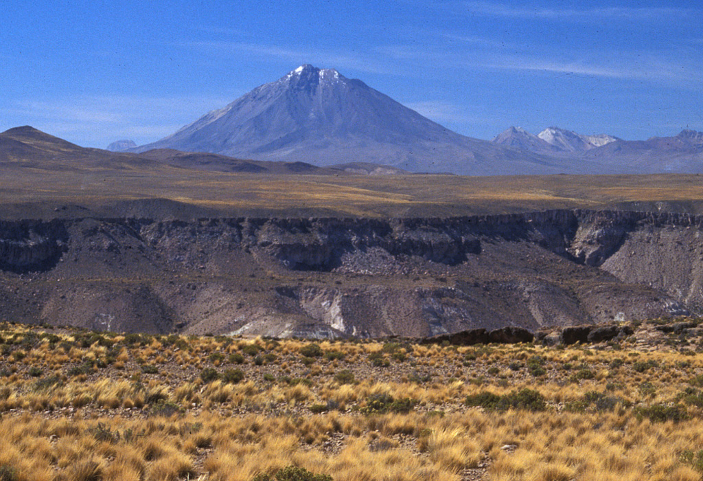
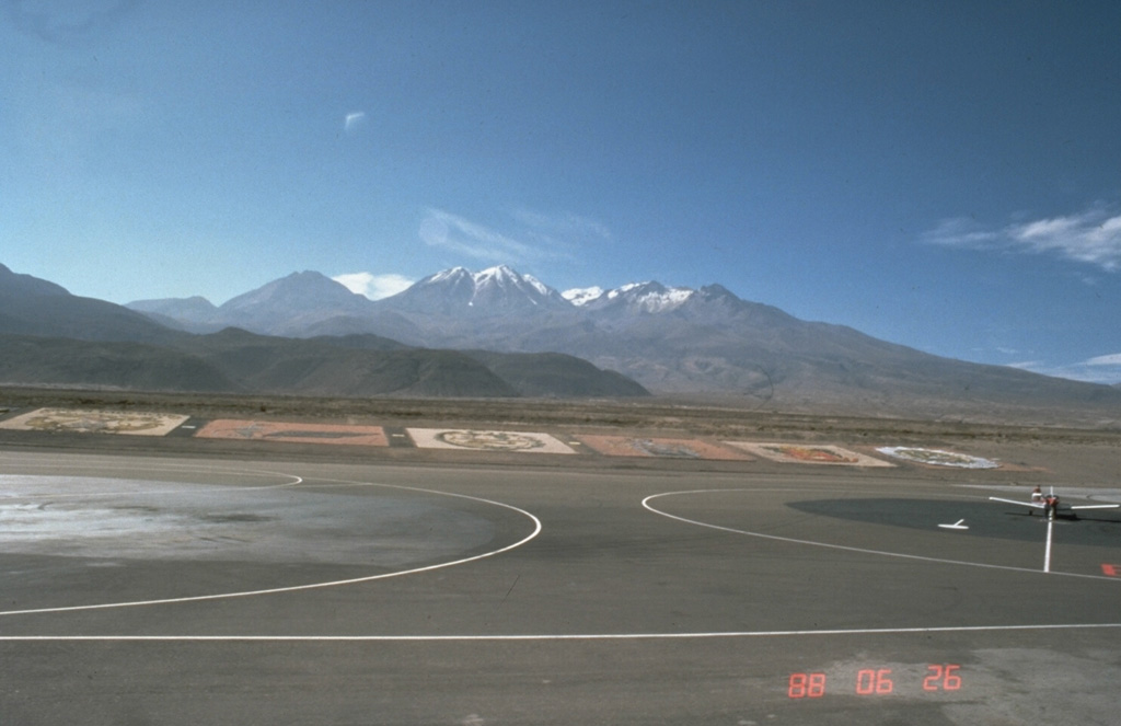
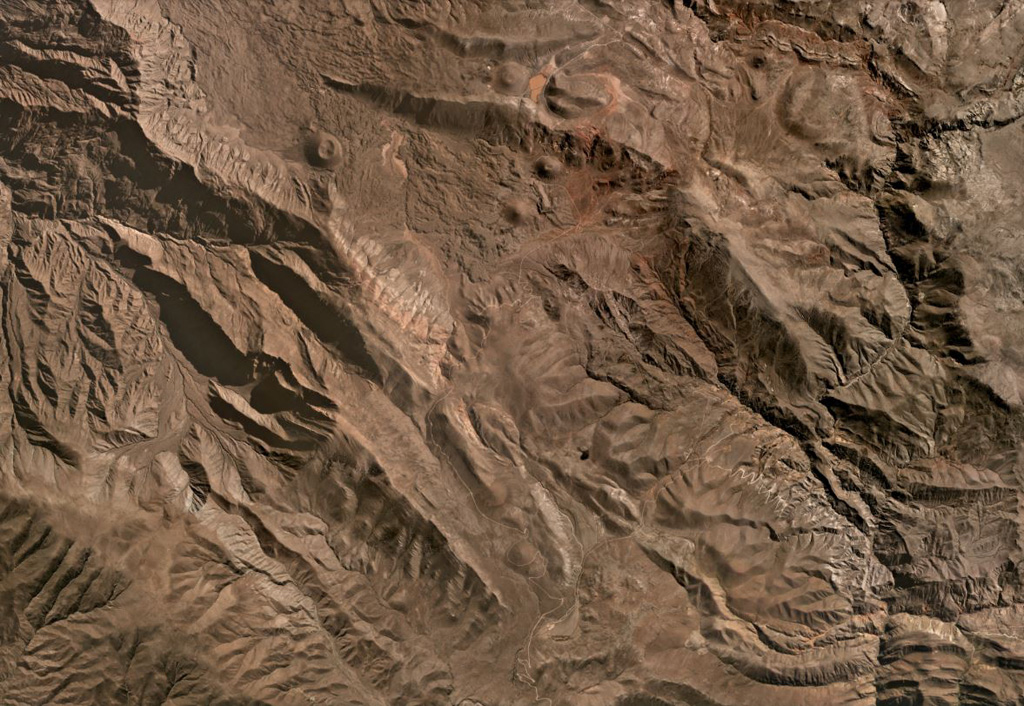
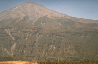
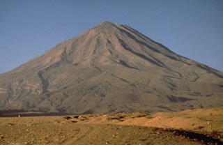
 Nevado Chachani volcano towers north of the international airport at Arequipa, Perú. The massive, 360 km2 volcanic complex includes a group of stratovolcanoes forming the horizon in this view, an older lava dome complex, and a younger SW-flank shield volcano. The dark hills in the left-center foreground are the distal margins of viscous lava flows from the Pampa de Placio, the SW-flank shield volcano. Volcanism has migrated to the west, and this marks the most recent activity of the Nevado Chachani complex.
 Photo by Norm Banks, 1988 (U.S. Geological Survey).
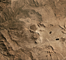
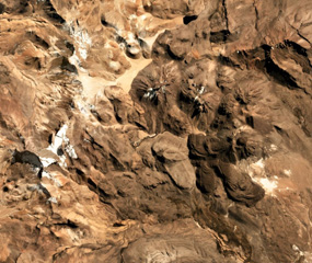 Four cones of the Nevados Casiri complex are seen in this July 2019 Planet Labs satellite image monthly mosaic (N is at the top; the image is approximately 11 km across). The three older cones are in a E-W trend, and the younger SE cone has a crater containing a dome along with two lava flows to the S and SE with visible levees and pressure ridges.
Satellite image courtesy of Planet Labs Inc., 2019 (https://www.planet.com/).
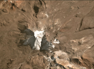
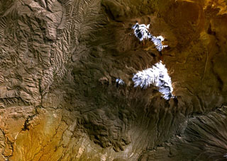 The glacier-capped Nevado de Chachani volcanic complex lies immediately north of the city of Arequipa. The central part of the 6057-m-high complex contains multiple vents along an arcuate line. Pleistocene lava domes form the glacier-covered northern end of the complex in this NASA image. A prominent lava-flow complex at the bottom-center part of the image with fresh-looking flow levees was erupted from the 8-km-wide lava shield of Pampa de Palacio of late-Pleistocene to possibly Holocene age.
NASA Landsat 7 image (worldwind.arc.nasa.gov)
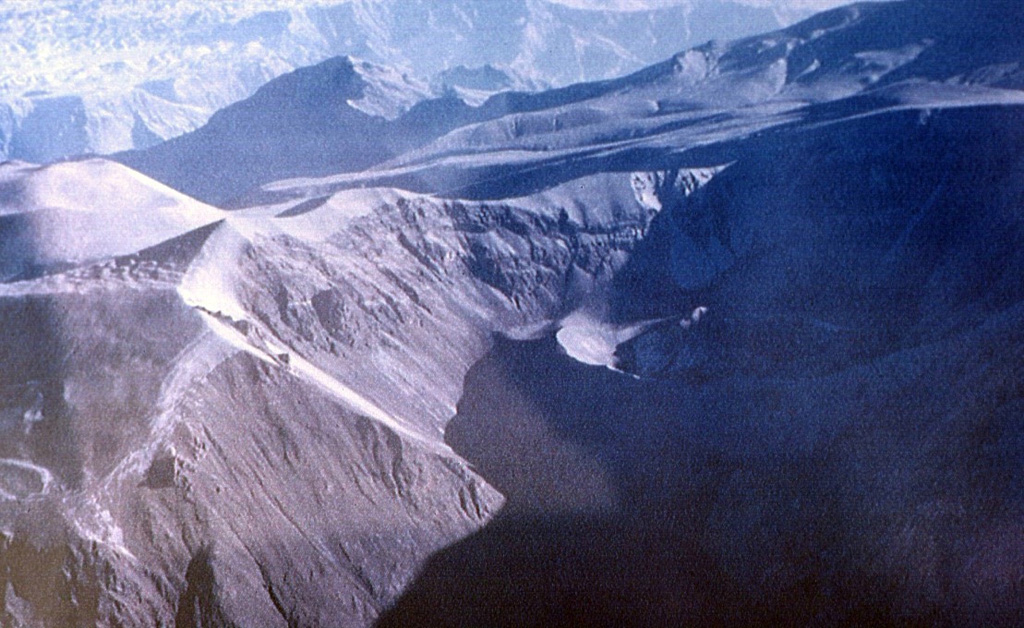
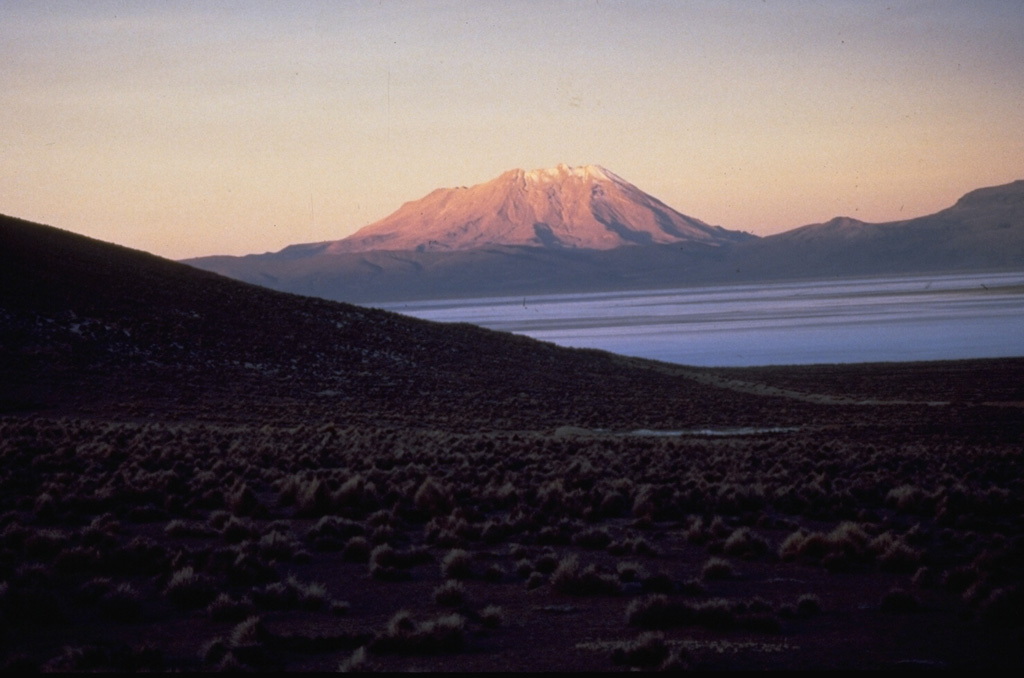
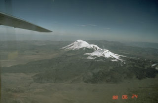
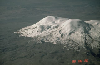
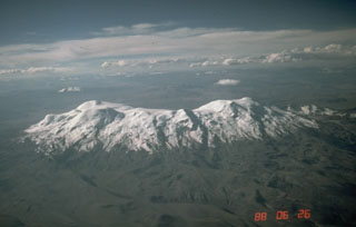 Nevado Coropuna, Perú's highest and largest volcano, is a massive ice-covered volcanic complex with at least a half dozen summit cones scattered over a 12 x 20 km area. The 6377-m-high summit (left), seen here from the south, is located at the NW end of the complex. Deep, steep-walled canyons surrounding the volcano give it an impressive topographic relief of more than 4000 m over a horizontal distance of 15 km. Several young Holocene lava flows descend the NE, SE, and western flanks.
 Photo by Norm Banks, 1988 (U.S. Geological Survey).
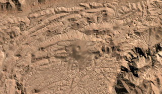 The isolated Cerro Nicholson scoria cone in Peru is shown in this July 2019 Planet Labs satellite image monthly mosaic (N is at the top; this image is approximately 6 km across). The monogenetic cone has a summit crater with a diameter of around 200 m.
Satellite image courtesy of Planet Labs Inc., 2019 (https://www.planet.com/).
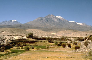 The Nevado de Chachani volcanic complex, seen here from the SW near the village of Yura, consists of a 360 km2 group of Pleistocene lava domes, a stratovolcano, and a shield volcano. The central, 6057-m-high Nevado Chachani complex contains multiple vents along an arcuate line, including a well-defined summit crater at the western end. Cerro La Horqueta (left horizon) may represent the latest activity from Nevado Chachani, after which activity migrated to the 8-km-wide Holocene lava shield of Pampa de Palacio on the south side.
Photo by Norm Banks, 1988 (U.S. Geological Survey).
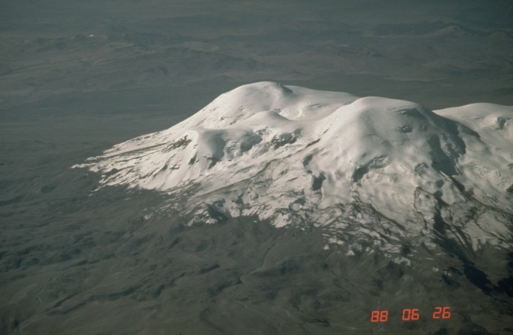
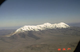
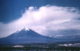 Towering 5980-m-high Tacora, the northernmost volcano of Chile, lies near the border with Perú and is a twin volcano with Chupiquina. Tacora is seen here from the SE. Although there have been uncertain reports of historical eruptions, and solfataric and fumarolic activity has been reported on the east side, Holocene eruptions from Tacora have not been documented.
Photo by Oscar González-Ferrán (University of Chile).
 Volcán Yucamane is composed of three main edifices, Yucamane Chico to the N, El Calientes in the middle, and Volcán Yucamane at the southern end, seen in this July 2019 Planet Labs satellite image monthly mosaic (N is at the top; the image is approximately 19.5 km across). Levees and pressure ridges are visible on lobate lava flows on the flanks.
Satellite image courtesy of Planet Labs Inc., 2019 (https://www.planet.com/).
 The elongated Coropuna volcanic massif is seen here from the NE. The dark lava flow descending the NE flank at the left center is one of several youthful lava flows that overlie roughly 11,000-year-old glacial moraines. The morphology of this flow and others on the SE and western flanks suggest that they are very young and postdate activity from the summit craters.
 Photo by Norm Banks, 1988 (U.S. Geological Survey).
 The cinder cones at the center and upper right, surrounded by a prominent field of lava flows, are located in the Andahua valley, known locally as the "Valley of the Volcanoes." The large 60 x 60 km scoria cone and lava field contains extremely youthful lava flows, some of which may be only a few hundred years old. The volcanic field was reported to have been active during the time of the Incas. Lava flows have repeatedly dammed the Río Andagua valley, and an existing small lake was impounded by the youngest lavas.
 Photo by Norm Banks, 1988 (U.S. Geological Survey).
 Volcán Ubinas, seen here from the west, is Perú's most active volcano. A small, 1.2-km-wide caldera that cuts the top of Ubinas gives it a truncated appearance. The upper slopes of the stratovolcano steepen to nearly 45 degrees. The steep-walled, 150-m-deep caldera contains an ash cone with a 500-m-wide funnel-shaped vent that is 200-m deep. Holocene lava flows are visible on the volcano's flanks, but historical activity, documented since the 16th century, has consisted of intermittent minor explosive eruptions.
 Photo by Norm Banks, 1988 (U.S. Geological Survey).
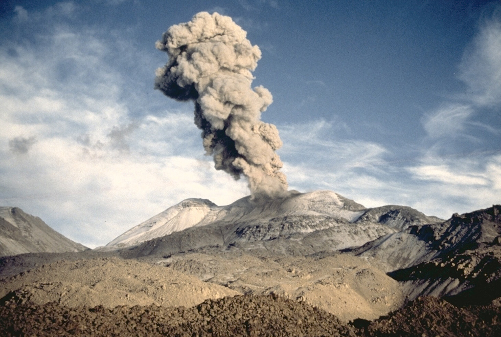
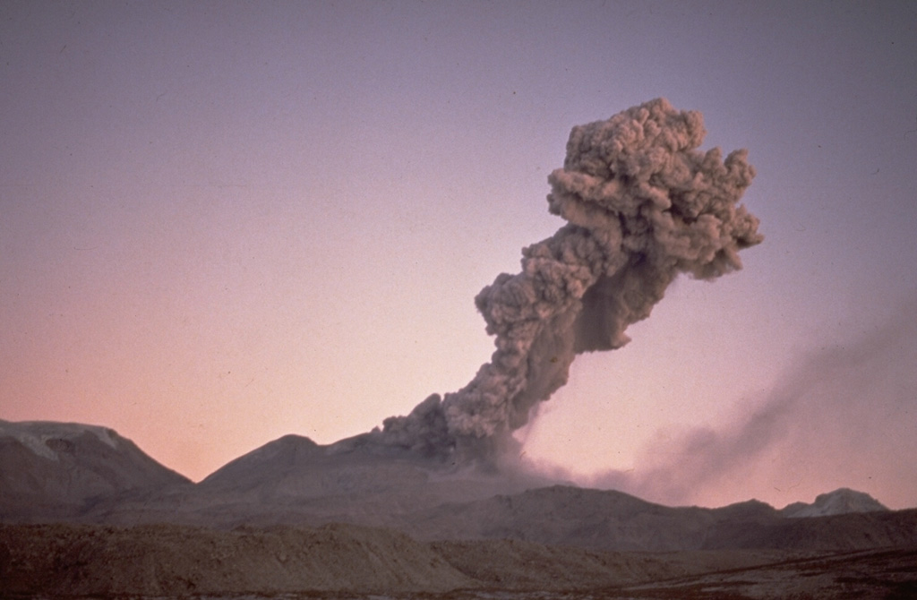
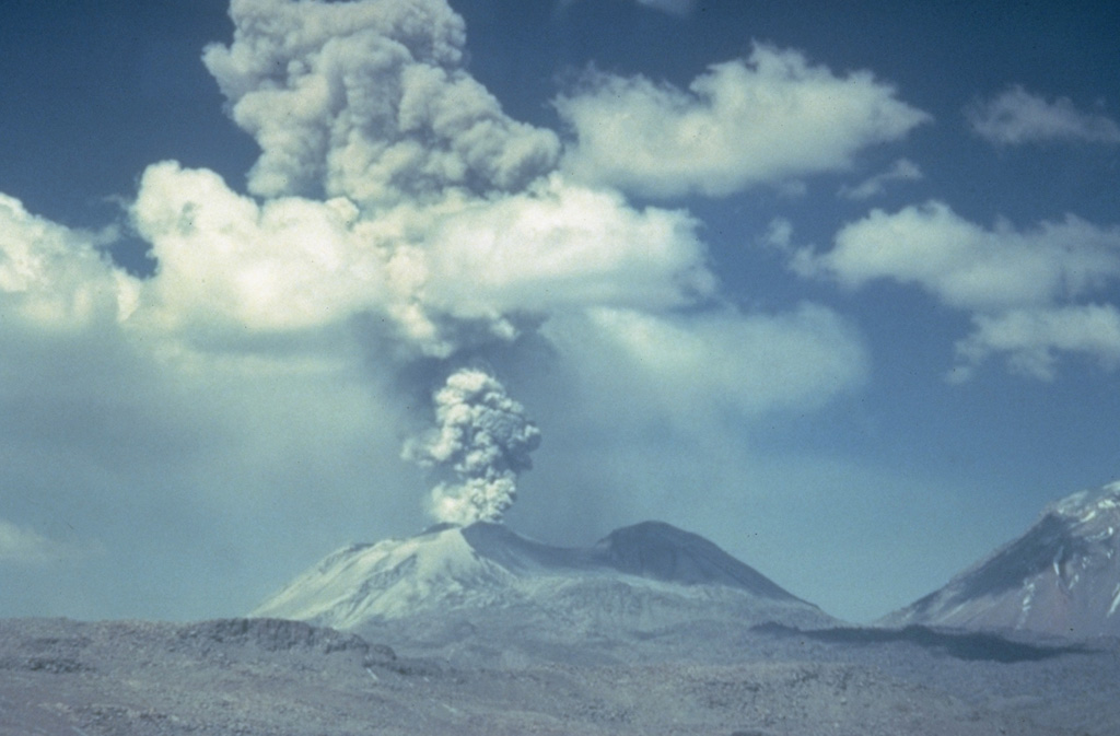
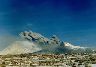
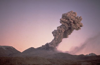 Winds deflect an eruption column from Sabancaya volcano to the NE on July 13, 1990. Residents living near the volcano reported an explosive eruption from Sabancaya that began on May 28, 1990. Initially, several explosions occurred per day, producing plumes to about 2 km height. Activity intensified on June 4, and by the 8th explosions occurred at intervals of 5-10 minutes and ashfall covered a radius of 20 km. More-or-less constant ash emission continued until 1998.
Photo by Guido Salas, 1990 (University of San Antonio, Arequipa).
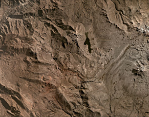 Several scoria cones of the Huambo volcanic field are visible in this July 2020 Planet Labs satellite image monthly mosaic (N is at the top; the image is approximately 40 km across). It has a northern and a southern field and contains up to 60 cones that span 300 to 1,200 m in diameter and up to 300 m in height. The upper area of this image N of the lake contains lava flows erupted from Cerro Keyocc the northern part of the field.
 Satellite image courtesy of Planet Labs Inc., 2020 (https://www.planet.com/).
 A Vulcanian ash plume, viewed from the SE, rises above Sabancaya volcano in northern Perú on 15 April 1991. Strong explosions were observed at intervals of 20-30 minutes during a visit to the volcano on 13-19 April. The explosions lasted about a minute and produced 3-4 km high ash plumes.
Photo by Pierre Vetsch, 1991.
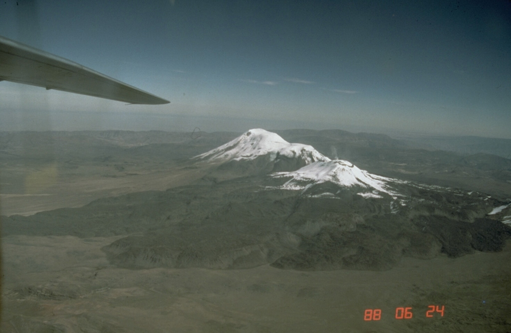
 The Sabancaya volcanic complex consists of Sabancaya volcano proper (foreground), the older 6288-m-high Ampato volcano (background), and 6025-m Hualca Hualca volcano. Sabancaya, viewed here from the NE, is constructed on the saddle between the two older volcanoes. It is the youngest of the three Holocene volcanic centers and the only one to have erupted in historical time. An extensive 15-km-wide apron of trachytic and dacitic lava flows surrounds the 5967-m-high volcano. Records of historical eruptions date back to 1750.
Photo by Norm Banks, 1988 (U.S. Geological Survey).
 A lava flow at Quimsachata scoria cone is visible in this October 2020 Planet Labs satellite image monthly mosaic (N is at the top). The flow erupted about 11,500 years ago and is approximately 4.7 km in the NW-SE direction. The smaller lava flow directly to the north was erupted from the Oroscocha lava dome about 6,400 years ago. These are the northernmost young volcanic centers in Perú.
Satellite image courtesy of Planet Labs Inc., 2020 (https://www.planet.com/).
 A dark-colored 15-km-wide apron of trachytic and dacitic lava flows surrounds 5967-m-high Sabancaya volcano. The prominent lava flow at the left extends more than 10 km down the SSE flank. Ampato volcano in the background forms the 6288-m high point of the Sabancaya volcanic complex. Amapato and Hualca Hualca volcano (out of view to the right) have also erupted during the Holocene, but only Sabancaya has erupted in historical time.
Photo by Norm Banks, 1988 (U.S. Geological Survey).
 The glacier-covered Nevado Firura volcanic complex is seen here from the NW. It consists of a 10-12 km long, NE-SW-trending cluster of small stratovolcanoes. The highest peak is 5500-m Nevado Firura itself (right center). Other volcanoes of the complex, including 5191-m-high Cerro Soncco Orcco, Cerro Jahsaya, and Antapuna are located to the SW, left of this view.
 Photo by Norm Banks, 1988 (U.S. Geological Survey).
 An explosive eruption from Sabancaya volcano is viewed from the east on June 9, 1990. Explosive activity, which had begun on May 28, 1990, was continuing in 1995. Sabancaya volcano was constructed on the saddle between Ampato (left) and Hualca Hualca volcanoes. Ashfall from Sabancaya in 1991, which accumulated on Hualca Hualca, caused increased melting of glaciers that produced mudflows down the Majes river drainage north of the volcano.
 Photo by Ch. Pattry, 1990 (courtesy of Alberto Parodi I.)
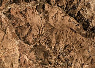
 This July 2020 Planet Labs satellite image shows some of the southern Huambo volcanic field (in this monthly mosaic N is at the top; image is approximately 26 km across). Near the top of the image, the western cone is Marbas Grande with a 470-m-wide summit crater. East of that are three cones: Marbas north of the ridge then Marbas Chico I and Marbas Chico II south of the ridge. Around the cones are their lava flows.
 Satellite image courtesy of Planet Labs Inc., 2020 (https://www.planet.com/).
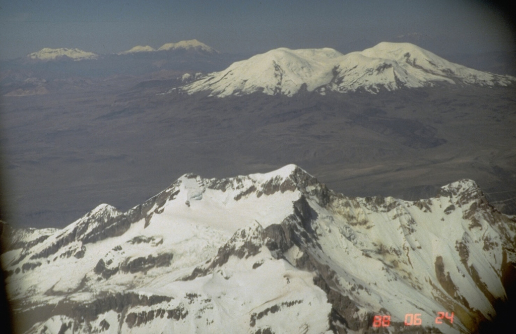
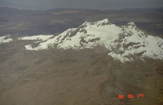
 The 6377-m-high summit of Coropuna volcano, Perú's highest, forms the peak at the center of the photo. It lies north of a 20-km-long E-W chain of peaks forming the ice-covered massif. The present glacial icecap covers an area of 130 km2 and descends to 5800 m on the south and 5300 m on the north. Dramatic lateral moraines from older glaciers extend up to 10 km and reach below 4500 m. Steep canyons on the volcano's flanks create among the world's highest topographic relief, up to 4000 m over a horizontal distance of 15 km.
Photo by Norm Banks, 1988 (U.S. Geological Survey).
 The Cerro Keyocc cone of the northern Huambo volcanic field is shown below the center of this July 2020 Planet Labs satellite image monthly mosaic (N is at the top; the image is approximately 13 km across). The cone produced a lava flow that traveled down the south of the cone then W, then N. The flow has many lobate breakout flows with pressure ridges along the surfaces.
Satellite image courtesy of Planet Labs Inc., 2020 (https://www.planet.com/).
 The Sabancaya volcanic complex, viewed here from the east, consists of 6288-m Ampato volcano (left), the eroded 6025-m-high Hualca Hualca volcano (right), and Sabancaya volcano proper (center), which was constructed on the saddle between the two older volcanoes. The two older centers have produced morphologically youthful lava flows, but 5967-m-high Sabancaya is the only center to have erupted in historical time.
Photo by Norm Banks, 1988 (U.S. Geological Survey).
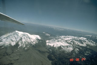
 Volcanoes of three ages can be seen in this aerial view across northern Perú. The eroded, 6093-m-high Solimana volcano (foreground) has not erupted since the Pleistocene, but has an active fumarole. It is located NW of the younger Coropuna volcano (upper right), which has produced major flank lava flows during the Holocene. The three-peaked Sabancaya volcanic complex (upper left) includes the historically active cone of Sabancaya proper, which is flanked on the left by Hualca Hualca volcano and on the right by Ampato volcano.
Photo by Norm Banks, 1988 (U.S. Geological Survey).
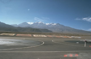
 El Misti, Perú's best known volcano, is a symmetrical stratovolcano that towers above the city of Arequipa. It is seen here from the west at the margin of Arequipa's airport. The modern symmetrical cone has a small, 1.5-km-wide summit caldera containing nested craters. It caps an older Pleistocene volcano that collapsed, producing debris avalanches to the west and SW. El Misti's most recent activity has been dominantly pyroclastic. Historical eruptions date back to the 15th century.
Photo by Norm Banks, 1988 (U.S. Geological Survey).
 Lava domes of Ticsani volcano are shown in the center of this August 2019 Planet Labs satellite monthly mosaic (N is at the top). The previous edifice collapsed to form an estimated 12 km3 debris avalanche deposit and has since emplaced these lava domes. This image is approximately 18.5 km across.
Satellite image courtesy of Planet Labs Inc., 2019 (https://www.planet.com/).
 Tacora, the northernmost volcano of Chile, rises to the NW above the steep-walled Allane valley. The 5980-m-high Tacora lies near the border with Perú and is a twin volcano with Chupiquina, hidden behind Tacora in this view. Although there have been uncertain reports of historical eruptions, and solfataric and fumarolic activity has been reported on the east side, Holocene eruptions have not been documented. The Arica to La Paz railway transects the plateau on the northern side of the Allane valley.
Photo by Lee Siebert, 2004 (Smithsonian Institution).
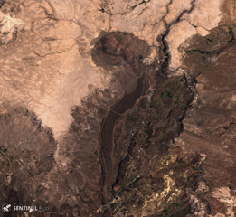 The lava flow down the center of this 3 December 2019 Sentinel-2 satellite image (N is at the top) was erupted from the Cerro Auquihuato scoria cone at its northern terminus. The flow is approximately 10 km long and reaches a thickness of 50 m.
Satellite image courtesy of Copernicus Sentinel Data, 2019.
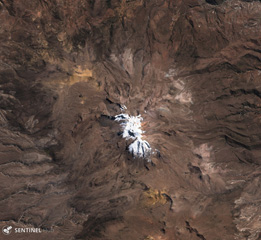 Glaciated Sara Sara volcano is in the center of this 22 July 2019 Sentinel-2 satellite image (N is at the top). A 15-km-long lava flow is visible on the eastern flank, with clear levees along the flow boundary. It is the westernmost young volcano in Peru and has produced intermittent explosive activity for less than 2 million years.
Satellite image courtesy of Copernicus Sentinel Data, 2019.
 Tutupaca consists of two eroded edifices that are seen in the center of this July 2020 Planet Labs satellite image monthly mosaic (N is at the top; the image is approximately 10 km across). The complex contains lava domes and a number of these have undergone collapse. The eastern edifice has a horseshoe-shaped collapse scarp that opens towards the NE.
Satellite image courtesy of Planet Labs Inc., 2020 (https://www.planet.com/).
This is a compilation of Peru volcano information sources, such as official monitoring or other government agencies.
| Civil Protection Agencies | |
|---|---|
| National Institute of Civil Defense (INDECI) of Peru | |
| Additional Information Sources | |
|---|---|
| Gobierno Regional de Moquegua | |