Earthquake swarm began in mid-2009
Morne aux Diables is the northermost of the nine volcanic centers on the island of Dominica (Lindsay and others, 2005) (figure 1). The complex (figures 2 and 3) is comprised of five intact andesitic crystal rich lava domes that form a central depression. Within the depression, a 'Cold Soufrière' is evident with hydrothermally altered rocks and many small bubbling pools. No historical eruptions are known, although the volcano has a youthful appearance, and activity at flank domes likely continued into the late Pleistocene and Holocene (Lindsay and others, 2005). Robert Watts, at the University of the West Indies (UWI) Seismic Research Centre, reported that the volcano remains quiet, though with noteworthy seismicity in 2009 and 2010.
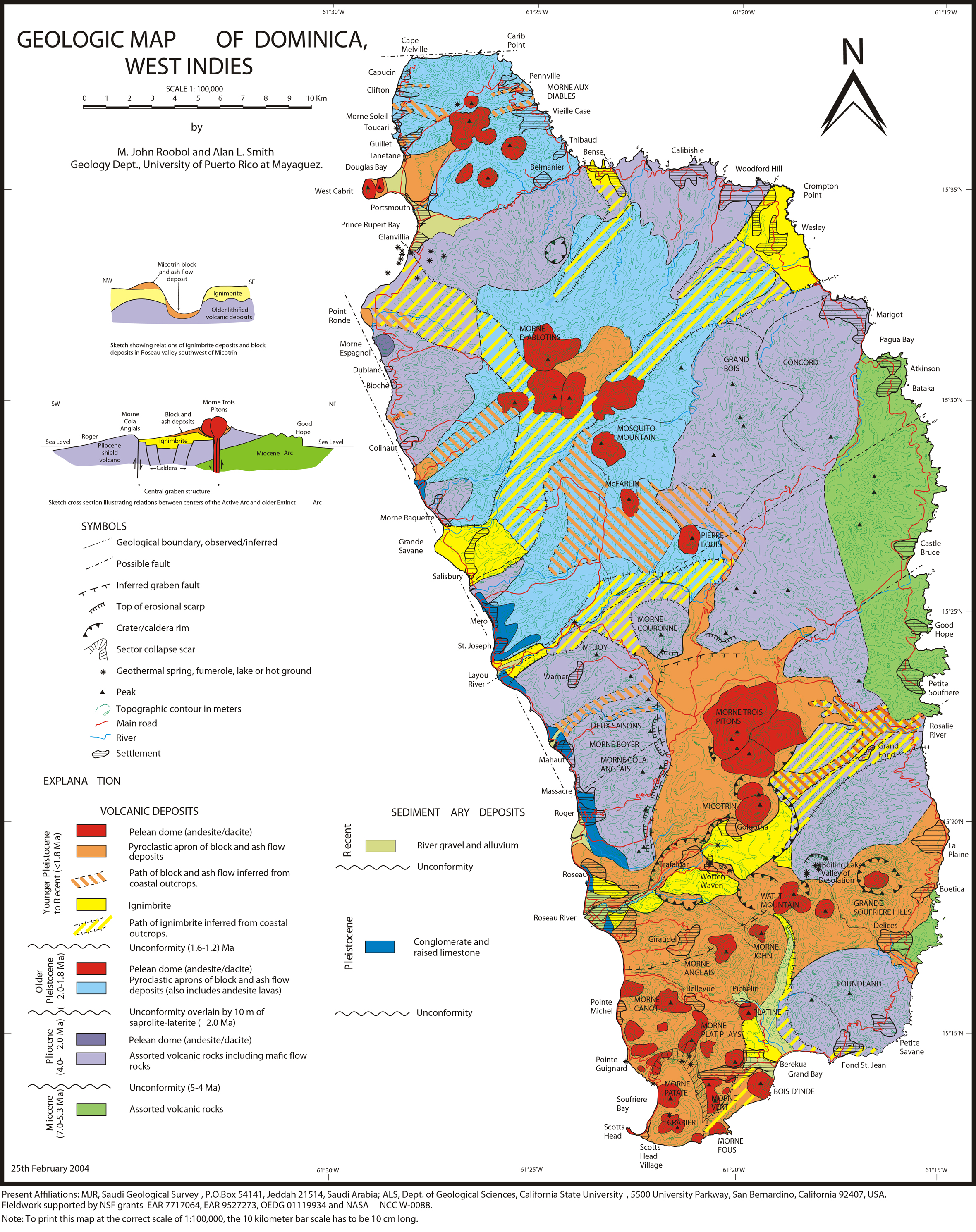 |
Figure 1. Geologic map of Dominica, West Indies, showing the Morne aux Diables complex at the N end of island. From N to S, generally, these nine centers are Morne aux Diables, Morne Diablotins, Morne Trois Pitons, Wotten Waven caldera, Valley of Desolation, Grande Soufrière Hills, Morne Watt, Morne Anglais, and Morne Plat Pays. Original map by Roobol and Smith (2004a) (see Roobol and Smith, 2004b); copied from Lindsey and others (2005). |
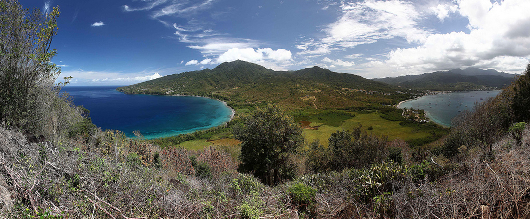 |
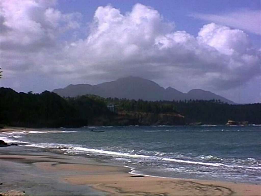
Figure 2. Panoramic view from E. Cabrits dome looking E to the Morne aux Diables complex. Morne Aux Diables is on the left and Morne Destinee to the right. Courtesy of Richard Arculus and Robert Watts. |
 |
Figure 3. Photograph of the Morne aux Diables complex, taken from near Portsmith Town. The topographic high Morne Aux Diables is on the left; Morne Heritiers, center; and Morne Destinee, right. Courtesy of Robert Watts. |
Watts, and Lindsay and others (2005), reported that in 2002 SeaBeam bathymetry highlighted a double peaked lava dome (known informally as Twin Peaks) on the sea floor a few kilometers off the northern coastline of Dominica. The summit of the higher dome (at 15.671?N, 61.476?W) was 153 m below sea level. This northern coastline terminating the N end of the Morne aux Diables complex forms a linear cliff that may represent a fault.
Seismic swarm during 2009-2010. The most common area of seismicity, as noted by Watts and others (2012a and 2012b), has been in the SE sector of Dominica. In the north there were spurts in activity in 1841, 1893, 2000, and a particularly intense week-long burst of more than 500 earthquakes in 2003. Following six years of low-level activity, a nearly continuous series of earthquakes was recorded beneath the central area of Morne aux Diables beginning in June 2009. The seismic swarm continued through at least 2010 with variations in activity that are consistent with volcano-tectonic (VT) activity.
The VT series reached a peak in December 2009, with many events felt by villagers on the flanks of the volcano, but earthquake activity afterwards gradually been diminishing. Beginning in December 2010, VT earthquakes exhibited a gradual shallowing with time (a few approaching 1 km depth), indicating that they are related to a vertical re adjustment of the stresses below the volcano, most likely caused by magma movement (Watts and others, 2012b).
References. Lindsay, J.M., Smith, A.L., Roobol, M.J., and Stasiuk, M.V., 2005, Dominica in Lindsay, J.M., Robertson, R.E.A., Shepherd, J.B. and Ali, S. (eds), Volcanic Hazard Atlas of the Lesser Antilles, Seismic Research Centre, The University of the West Indies, Trinidad & Tobago, West Indies, p. 1-48.
Roobol, M.J., and Smith, A.L., 2004a. Volcanology of Saba and St. Eustatius, northern Lesser Antilles, Amsterdam: Royal Netherlands Academy of Arts and Letters, 320 p.
Roobol, M.J., and Smith, A.L., 2004b, Geologic map of Dominica, West Indies (URL: http://www.caribbeanvolcanoes.com/dominica/content/dominicamap.pdf).
Watts, R.B., Robertson, R.E., Abraham, W., Cole, P., de Roche, T., Edwards, S., Higgins, M., Johnson, M., Joseph, E.P., Latchman, J., Lynch, L., Nisha, N., Ramsingh, C., and Stewart, R.C., 2012a , Elevated seismic activity beneath the slumbering Morne aux Diables volcano, Northern Dominica and the monitoring role of the Seismic Research Center, poster presentation at the 2012 American Geophyhsical Union Fall Meeting, San Francisco, CA.
Watts, R., Robertson, R., Abraham, W., Cole, P., Corriette, D., de Roche, T., Edwards, S., Higgins, M., Issacs, N., Johnson, M., Joseph, E., Latchman, J., Lynch, L., Nisha, N., Phillip, B., Ramsingh, C., and Stewart, R., 2012b, Elevated seismic activity beneath the slumbering Morne aux Diables volcano, northern Dominica, poster on UWISRC web (URL: http://www.uwiseismic.com/Downloads/Dominica_activity_Poster_Watts.pdf).
Information Contacts: Robert B. Watts, The University of the West Indies (UWI) Seismic Research Centre, St. Augustine, Trinidad & Tobago, West Indies (URL: http://www.uwiseismic.com/).
The Global Volcanism Program has no Weekly Reports available for Morne aux Diables.
Reports are organized chronologically and indexed below by Month/Year (Publication Volume:Number), and include a one-line summary. Click on the index link or scroll down to read the reports.
Earthquake swarm began in mid-2009
Morne aux Diables is the northermost of the nine volcanic centers on the island of Dominica (Lindsay and others, 2005) (figure 1). The complex (figures 2 and 3) is comprised of five intact andesitic crystal rich lava domes that form a central depression. Within the depression, a 'Cold Soufrière' is evident with hydrothermally altered rocks and many small bubbling pools. No historical eruptions are known, although the volcano has a youthful appearance, and activity at flank domes likely continued into the late Pleistocene and Holocene (Lindsay and others, 2005). Robert Watts, at the University of the West Indies (UWI) Seismic Research Centre, reported that the volcano remains quiet, though with noteworthy seismicity in 2009 and 2010.
|
Figure 1. Geologic map of Dominica, West Indies, showing the Morne aux Diables complex at the N end of island. From N to S, generally, these nine centers are Morne aux Diables, Morne Diablotins, Morne Trois Pitons, Wotten Waven caldera, Valley of Desolation, Grande Soufrière Hills, Morne Watt, Morne Anglais, and Morne Plat Pays. Original map by Roobol and Smith (2004a) (see Roobol and Smith, 2004b); copied from Lindsey and others (2005). |
|
Figure 2. Panoramic view from E. Cabrits dome looking E to the Morne aux Diables complex. Morne Aux Diables is on the left and Morne Destinee to the right. Courtesy of Richard Arculus and Robert Watts. |
|
Figure 3. Photograph of the Morne aux Diables complex, taken from near Portsmith Town. The topographic high Morne Aux Diables is on the left; Morne Heritiers, center; and Morne Destinee, right. Courtesy of Robert Watts. |
Watts, and Lindsay and others (2005), reported that in 2002 SeaBeam bathymetry highlighted a double peaked lava dome (known informally as Twin Peaks) on the sea floor a few kilometers off the northern coastline of Dominica. The summit of the higher dome (at 15.671?N, 61.476?W) was 153 m below sea level. This northern coastline terminating the N end of the Morne aux Diables complex forms a linear cliff that may represent a fault.
Seismic swarm during 2009-2010. The most common area of seismicity, as noted by Watts and others (2012a and 2012b), has been in the SE sector of Dominica. In the north there were spurts in activity in 1841, 1893, 2000, and a particularly intense week-long burst of more than 500 earthquakes in 2003. Following six years of low-level activity, a nearly continuous series of earthquakes was recorded beneath the central area of Morne aux Diables beginning in June 2009. The seismic swarm continued through at least 2010 with variations in activity that are consistent with volcano-tectonic (VT) activity.
The VT series reached a peak in December 2009, with many events felt by villagers on the flanks of the volcano, but earthquake activity afterwards gradually been diminishing. Beginning in December 2010, VT earthquakes exhibited a gradual shallowing with time (a few approaching 1 km depth), indicating that they are related to a vertical re adjustment of the stresses below the volcano, most likely caused by magma movement (Watts and others, 2012b).
References. Lindsay, J.M., Smith, A.L., Roobol, M.J., and Stasiuk, M.V., 2005, Dominica in Lindsay, J.M., Robertson, R.E.A., Shepherd, J.B. and Ali, S. (eds), Volcanic Hazard Atlas of the Lesser Antilles, Seismic Research Centre, The University of the West Indies, Trinidad & Tobago, West Indies, p. 1-48.
Roobol, M.J., and Smith, A.L., 2004a. Volcanology of Saba and St. Eustatius, northern Lesser Antilles, Amsterdam: Royal Netherlands Academy of Arts and Letters, 320 p.
Roobol, M.J., and Smith, A.L., 2004b, Geologic map of Dominica, West Indies (URL: http://www.caribbeanvolcanoes.com/dominica/content/dominicamap.pdf).
Watts, R.B., Robertson, R.E., Abraham, W., Cole, P., de Roche, T., Edwards, S., Higgins, M., Johnson, M., Joseph, E.P., Latchman, J., Lynch, L., Nisha, N., Ramsingh, C., and Stewart, R.C., 2012a , Elevated seismic activity beneath the slumbering Morne aux Diables volcano, Northern Dominica and the monitoring role of the Seismic Research Center, poster presentation at the 2012 American Geophyhsical Union Fall Meeting, San Francisco, CA.
Watts, R., Robertson, R., Abraham, W., Cole, P., Corriette, D., de Roche, T., Edwards, S., Higgins, M., Issacs, N., Johnson, M., Joseph, E., Latchman, J., Lynch, L., Nisha, N., Phillip, B., Ramsingh, C., and Stewart, R., 2012b, Elevated seismic activity beneath the slumbering Morne aux Diables volcano, northern Dominica, poster on UWISRC web (URL: http://www.uwiseismic.com/Downloads/Dominica_activity_Poster_Watts.pdf).
Information Contacts: Robert B. Watts, The University of the West Indies (UWI) Seismic Research Centre, St. Augustine, Trinidad & Tobago, West Indies (URL: http://www.uwiseismic.com/).
|
|
||||||||||||||||||||||||||
The Global Volcanism Program is not aware of any Holocene eruptions from Morne aux Diables. If this volcano has had large eruptions (VEI >= 4) prior to 12,000 years ago, information might be found on the Morne aux Diables page in the LaMEVE (Large Magnitude Explosive Volcanic Eruptions) database, a part of the Volcano Global Risk Identification and Analysis Project (VOGRIPA).
This compilation of synonyms and subsidiary features may not be comprehensive. Features are organized into four major categories: Cones, Craters, Domes, and Thermal Features. Synonyms of features appear indented below the primary name. In some cases additional feature type, elevation, or location details are provided.
Domes |
||||
| Feature Name | Feature Type | Elevation | Latitude | Longitude |
| Bellevue Mountain | Dome | 670 m | 15° 37' 0.00" N | 61° 27' 0.00" W |
| Brulés, Morne | Dome | 15° 35' 0.00" N | 61° 27' 0.00" W | |
| Destinée, Morne | Dome | 15° 35' 0.00" N | 61° 26' 0.00" W | |
| East Cabrit | Dome | 140 m | 15° 35' 0.00" N | 61° 29' 0.00" W |
| Twin Peaks | Dome | -153 m | 15° 40' 15.00" N | 61° 28' 35.00" W |
| West Cabrit | Dome | 170 m | 15° 35' 0.00" N | 61° 29' 0.00" W |
Thermal |
||||
| Feature Name | Feature Type | Elevation | Latitude | Longitude |
| Penville Cold Soufrière | Fumarole | |||
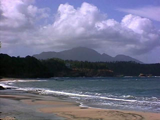 Morne aux Diables stratovolcano at the northern tip of the island of Dominica rises above beaches on the NE shore of the island near the village of Calibishie. Several nested craters and a 90-m-high, 335-m-wide lava dome are located within a larger 1.2-km-wide crater. The youngest, NW crater contains an active fumarolic area. No eruptions are known in historical time. Severe earthquake swarms in 1841 and 1893 were associated with either Morne aux Daibles or Morne Diablotins to the south.
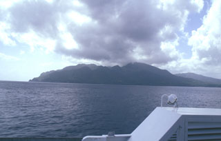 The NW side of Morne aux Diables volcano at the northern tip of Dominica is seen from the hydrofoil ferry between Guadeloupe and Dominica. Lava domes are prominent on the 681-m-high volcano, both at the summit and its flanks. Bathymetry reveals evidence for a twin-peaked lava dome about 5 km off the NW coast that reaches to within 153 m of the sea surface. Both domes, known informally as Twin Peaks, rise more than 1000 m above the sea floor.
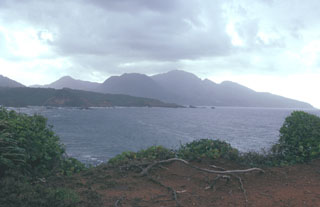 Morne aux Diables volcano rises above the Atlantic coast of NW Dominica. The summit of the volcano is formed by a complex of lava domes, and flank domes, which extend in a roughly E-W chain across the southern flank of the volcano, are visible on the left horizon.
 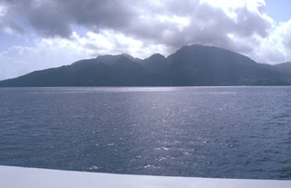 Morne aux Diables volcano at the northern tip of Dominica is a stratovolcano composed of andesitic lava domes, lava flows, and block-and-ash flow deposits well exposed in coastal sea cliffs. Volcanism at the dominantly Pleistocene Morne aux Diables is considered to have likely continued into the Holocene; unconsolidated block-and-ash flow deposits extend to the NW and NE coasts. Fumarolic areas are present on the volcano, and the Penville Cold Soufrière, an area of bubbling pools, lies within the youngest crater of the volcano.
 There are no samples for Morne aux Diables in the Smithsonian's NMNH Department of Mineral Sciences Rock and Ore collection.
| Copernicus Browser | The Copernicus Browser replaced the Sentinel Hub Playground browser in 2023, to provide access to Earth observation archives from the Copernicus Data Space Ecosystem, the main distribution platform for data from the EU Copernicus missions. |
| MIROVA | Middle InfraRed Observation of Volcanic Activity (MIROVA) is a near real time volcanic hot-spot detection system based on the analysis of MODIS (Moderate Resolution Imaging Spectroradiometer) data. In particular, MIROVA uses the Middle InfraRed Radiation (MIR), measured over target volcanoes, in order to detect, locate and measure the heat radiation sourced from volcanic activity. |
| MODVOLC Thermal Alerts | Using infrared satellite Moderate Resolution Imaging Spectroradiometer (MODIS) data, scientists at the Hawai'i Institute of Geophysics and Planetology, University of Hawai'i, developed an automated system called MODVOLC to map thermal hot-spots in near real time. For each MODIS image, the algorithm automatically scans each 1 km pixel within it to check for high-temperature hot-spots. When one is found the date, time, location, and intensity are recorded. MODIS looks at every square km of the Earth every 48 hours, once during the day and once during the night, and the presence of two MODIS sensors in space allows at least four hot-spot observations every two days. Each day updated global maps are compiled to display the locations of all hot spots detected in the previous 24 hours. There is a drop-down list with volcano names which allow users to 'zoom-in' and examine the distribution of hot-spots at a variety of spatial scales. |
|
WOVOdat
Single Volcano View Temporal Evolution of Unrest Side by Side Volcanoes |
WOVOdat is a database of volcanic unrest; instrumentally and visually recorded changes in seismicity, ground deformation, gas emission, and other parameters from their normal baselines. It is sponsored by the World Organization of Volcano Observatories (WOVO) and presently hosted at the Earth Observatory of Singapore.
GVMID Data on Volcano Monitoring Infrastructure The Global Volcano Monitoring Infrastructure Database GVMID, is aimed at documenting and improving capabilities of volcano monitoring from the ground and space. GVMID should provide a snapshot and baseline view of the techniques and instrumentation that are in place at various volcanoes, which can be use by volcano observatories as reference to setup new monitoring system or improving networks at a specific volcano. These data will allow identification of what monitoring gaps exist, which can be then targeted by remote sensing infrastructure and future instrument deployments. |
| Volcanic Hazard Maps | The IAVCEI Commission on Volcanic Hazards and Risk has a Volcanic Hazard Maps database designed to serve as a resource for hazard mappers (or other interested parties) to explore how common issues in hazard map development have been addressed at different volcanoes, in different countries, for different hazards, and for different intended audiences. In addition to the comprehensive, searchable Volcanic Hazard Maps Database, this website contains information about diversity of volcanic hazard maps, illustrated using examples from the database. This site is for educational purposes related to volcanic hazard maps. Hazard maps found on this website should not be used for emergency purposes. For the most recent, official hazard map for a particular volcano, please seek out the proper institutional authorities on the matter. |
| IRIS seismic stations/networks | Incorporated Research Institutions for Seismology (IRIS) Data Services map showing the location of seismic stations from all available networks (permanent or temporary) within a radius of 0.18° (about 20 km at mid-latitudes) from the given location of Morne aux Diables. Users can customize a variety of filters and options in the left panel. Note that if there are no stations are known the map will default to show the entire world with a "No data matched request" error notice. |
| UNAVCO GPS/GNSS stations | Geodetic Data Services map from UNAVCO showing the location of GPS/GNSS stations from all available networks (permanent or temporary) within a radius of 20 km from the given location of Morne aux Diables. Users can customize the data search based on station or network names, location, and time window. Requires Adobe Flash Player. |
| DECADE Data | The DECADE portal, still in the developmental stage, serves as an example of the proposed interoperability between The Smithsonian Institution's Global Volcanism Program, the Mapping Gas Emissions (MaGa) Database, and the EarthChem Geochemical Portal. The Deep Earth Carbon Degassing (DECADE) initiative seeks to use new and established technologies to determine accurate global fluxes of volcanic CO2 to the atmosphere, but installing CO2 monitoring networks on 20 of the world's 150 most actively degassing volcanoes. The group uses related laboratory-based studies (direct gas sampling and analysis, melt inclusions) to provide new data for direct degassing of deep earth carbon to the atmosphere. |
| Large Eruptions of Morne aux Diables | Information about large Quaternary eruptions (VEI >= 4) is cataloged in the Large Magnitude Explosive Volcanic Eruptions (LaMEVE) database of the Volcano Global Risk Identification and Analysis Project (VOGRIPA). |
| EarthChem | EarthChem develops and maintains databases, software, and services that support the preservation, discovery, access and analysis of geochemical data, and facilitate their integration with the broad array of other available earth science parameters. EarthChem is operated by a joint team of disciplinary scientists, data scientists, data managers and information technology developers who are part of the NSF-funded data facility Integrated Earth Data Applications (IEDA). IEDA is a collaborative effort of EarthChem and the Marine Geoscience Data System (MGDS). |

