Local volcanologists reported that there was increased seismicity at Tenerife in mid-May, according to a news article. The article stated that during several days before 18 May there were "five successive low-intensity earthquakes in the island's most volcanically active zone in the area between Mont Teide and Santiago del Teide." The director of the Estación Vulcanológica de Canarias stated that the earthquakes, which were less than M 2, could be an early sign that something unusual was happening at the volcano.
Source: Yorkshire Post Today News
2004 seismic crisis; January 2005 escalation in monitored parameters at Tiede
Juan Carlos Carracedo notified Bulletin editors that seismic activity in Tenerife during April and May 2004 was not followed by any volcanic activity. More than 200 earthquakes from magnitude 1 to 3 were recorded, but residents felt only three of them. Most of the epicenters were localized around the NW rift zone of Tenerife and in the strait between Gran Canaria and Tenerife. The crisis was probably related to dike emplacement at 3-4 km depth.
On 12 January 2005, an increase in unrest at Tenerife's Teide volcano over the previous 2 weeks was reported. Carbon dioxide emissions rose from 75 to 354 tons per day, and hydrogen sulfide emissions rose from 35 to 152 tons per day. Seismic activity remained elevated under the volcano. Fumaroles increased in pressure, and emitted sounds. No significant ground deformation was observed.
In a recent article in Eos, scientists from Spain and The Netherlands (Garcia et al., 2006), described a monitoring program for the Canary Islands. They noted that the Canary Islands started to show signs of seismo-volcanic activity at the end of 2003. In spring 2004, there was a significant increase in the number of seismic events (a mixture of regional, volcano-tectonic, and volcanic events such as tremor and long-period signals) located beneath Tenerife Island. The authors also noted an increase of fumarolic activity, an increase in carbon dioxide emissions in the NW part of the island, and changes in the gravimetric field on the N flank. After several seismic events had been felt by the population, the first alert level was declared by the civil protection division of the local government.
The volcano has a history of large eruptions destructive to populated areas. The authors reported that in 1992, the International Association of Volcanology and Chemistry of the Earth's Interior (IAVCEI) identified Teide, with its high-risk level, as one of the European Laboratory Volcanoes, thus receiving special consideration from the European Union concerning research proposals.
In the spring of 2005, the Spanish National Research Council (CSIC) initiated the TEGETEIDE project (Geophysical and Geodetic Techniques for the Study of the Teide-Pico Active Volcanic Area). It will monitor the seismicity of the volcano and include background noise analysis. The system's main goal is to detect precursors to a potentially dangerous eruptive episode at an early stage. The scheme is to use signals in both the time and the spectral domains.
References. Garcia, A., Vila, J., Ortiz, R., Macia, R., Sleeman, R., Marrero, J.M., Sanchez, N., Tarraga, M., Correig, A.M., 2006, Monitoring the reawakening of Canary Islands' Teide Volcano: EOS Transactions, American Geophysical Union, v. 87, no. 6, p. 61, 65.
Information Contacts: Juan Carlos Carracedo, Estación Volcanológica de Canarias, Consejo Superior de Investigaciones Científicas (CSIC, Spanish National Research Council), Serrano, 117 28006, Madrid, Spain; Josep Vila, Departament d'Astronomia i Meteorologia, Universitat de Barcelona and Laboratori d'Estudis Geofísics "Eduard Fontserè," Institut d'Estudis Catalans, Barcelona, Spain.
2004: May
Local volcanologists reported that there was increased seismicity at Tenerife in mid-May, according to a news article. The article stated that during several days before 18 May there were "five successive low-intensity earthquakes in the island's most volcanically active zone in the area between Mont Teide and Santiago del Teide." The director of the Estación Vulcanológica de Canarias stated that the earthquakes, which were less than M 2, could be an early sign that something unusual was happening at the volcano.
Source: Yorkshire Post Today News
Reports are organized chronologically and indexed below by Month/Year (Publication Volume:Number), and include a one-line summary. Click on the index link or scroll down to read the reports.
2004 seismic crisis; January 2005 escalation in monitored parameters at Tiede
Juan Carlos Carracedo notified Bulletin editors that seismic activity in Tenerife during April and May 2004 was not followed by any volcanic activity. More than 200 earthquakes from magnitude 1 to 3 were recorded, but residents felt only three of them. Most of the epicenters were localized around the NW rift zone of Tenerife and in the strait between Gran Canaria and Tenerife. The crisis was probably related to dike emplacement at 3-4 km depth.
On 12 January 2005, an increase in unrest at Tenerife's Teide volcano over the previous 2 weeks was reported. Carbon dioxide emissions rose from 75 to 354 tons per day, and hydrogen sulfide emissions rose from 35 to 152 tons per day. Seismic activity remained elevated under the volcano. Fumaroles increased in pressure, and emitted sounds. No significant ground deformation was observed.
In a recent article in Eos, scientists from Spain and The Netherlands (Garcia et al., 2006), described a monitoring program for the Canary Islands. They noted that the Canary Islands started to show signs of seismo-volcanic activity at the end of 2003. In spring 2004, there was a significant increase in the number of seismic events (a mixture of regional, volcano-tectonic, and volcanic events such as tremor and long-period signals) located beneath Tenerife Island. The authors also noted an increase of fumarolic activity, an increase in carbon dioxide emissions in the NW part of the island, and changes in the gravimetric field on the N flank. After several seismic events had been felt by the population, the first alert level was declared by the civil protection division of the local government.
The volcano has a history of large eruptions destructive to populated areas. The authors reported that in 1992, the International Association of Volcanology and Chemistry of the Earth's Interior (IAVCEI) identified Teide, with its high-risk level, as one of the European Laboratory Volcanoes, thus receiving special consideration from the European Union concerning research proposals.
In the spring of 2005, the Spanish National Research Council (CSIC) initiated the TEGETEIDE project (Geophysical and Geodetic Techniques for the Study of the Teide-Pico Active Volcanic Area). It will monitor the seismicity of the volcano and include background noise analysis. The system's main goal is to detect precursors to a potentially dangerous eruptive episode at an early stage. The scheme is to use signals in both the time and the spectral domains.
References. Garcia, A., Vila, J., Ortiz, R., Macia, R., Sleeman, R., Marrero, J.M., Sanchez, N., Tarraga, M., Correig, A.M., 2006, Monitoring the reawakening of Canary Islands' Teide Volcano: EOS Transactions, American Geophysical Union, v. 87, no. 6, p. 61, 65.
Information Contacts: Juan Carlos Carracedo, Estación Volcanológica de Canarias, Consejo Superior de Investigaciones Científicas (CSIC, Spanish National Research Council), Serrano, 117 28006, Madrid, Spain; Josep Vila, Departament d'Astronomia i Meteorologia, Universitat de Barcelona and Laboratori d'Estudis Geofísics "Eduard Fontserè," Institut d'Estudis Catalans, Barcelona, Spain.
|
|
||||||||||||||||||||||||||
There is data available for 42 confirmed Holocene eruptive periods.
1909 Nov 18 - 1909 Nov 27 Confirmed Eruption (Explosive / Effusive) VEI: 2
| Episode 1 | Eruption (Explosive / Effusive) | NW rift zone (Chinyero) | ||||||||||||||||||||||||||||||||||
|---|---|---|---|---|---|---|---|---|---|---|---|---|---|---|---|---|---|---|---|---|---|---|---|---|---|---|---|---|---|---|---|---|---|---|---|
| 1909 Nov 18 - 1909 Nov 27 | Evidence from Observations: Reported | ||||||||||||||||||||||||||||||||||
|
List of 5 Events for Episode 1 at NW rift zone (Chinyero)
|
|||||||||||||||||||||||||||||||||||
1798 Jun 9 - 1798 Sep 14 (?) Confirmed Eruption (Explosive / Effusive) VEI: 3
| Episode 1 | Eruption (Explosive / Effusive) | SW flank of Pico Viejo (Chahorra) | ||||||||||||||||||||||||||||||||||||||||||||
|---|---|---|---|---|---|---|---|---|---|---|---|---|---|---|---|---|---|---|---|---|---|---|---|---|---|---|---|---|---|---|---|---|---|---|---|---|---|---|---|---|---|---|---|---|---|
| 1798 Jun 9 - 1798 Sep 14 (?) | Evidence from Observations: Reported | ||||||||||||||||||||||||||||||||||||||||||||
|
List of 7 Events for Episode 1 at SW flank of Pico Viejo (Chahorra)
|
|||||||||||||||||||||||||||||||||||||||||||||
1706 May 5 - 1706 Jun 13 Confirmed Eruption (Explosive / Effusive) VEI: 2
| Episode 1 | Eruption (Explosive / Effusive) | NW rift zone (Garachico) | ||||||||||||||||||||||||||||||||||||||||||||||||||||||
|---|---|---|---|---|---|---|---|---|---|---|---|---|---|---|---|---|---|---|---|---|---|---|---|---|---|---|---|---|---|---|---|---|---|---|---|---|---|---|---|---|---|---|---|---|---|---|---|---|---|---|---|---|---|---|---|
| 1706 May 5 - 1706 Jun 13 | Evidence from Observations: Reported | ||||||||||||||||||||||||||||||||||||||||||||||||||||||
|
List of 9 Events for Episode 1 at NW rift zone (Garachico)
|
|||||||||||||||||||||||||||||||||||||||||||||||||||||||
1704 Dec 31 - 1705 Mar 27 Confirmed Eruption (Explosive / Effusive) VEI: 2
| Episode 1 | Eruption (Explosive / Effusive) | NW rift zone (Siete Fuentes, Fasnia, Güímar) | |||||||||||||||||||||||||||||||||||||||||||||||||
|---|---|---|---|---|---|---|---|---|---|---|---|---|---|---|---|---|---|---|---|---|---|---|---|---|---|---|---|---|---|---|---|---|---|---|---|---|---|---|---|---|---|---|---|---|---|---|---|---|---|---|
| 1704 Dec 31 - 1705 Mar 27 | Evidence from Observations: Reported | |||||||||||||||||||||||||||||||||||||||||||||||||
|
List of 8 Events for Episode 1 at NW rift zone (Siete Fuentes, Fasnia, Güímar)
|
||||||||||||||||||||||||||||||||||||||||||||||||||
1492 Aug 24 (on or before) Confirmed Eruption (Explosive / Effusive)
| Episode 1 | Eruption (Explosive / Effusive) | NW rift zone (Montaña Boca Cangrejo) | ||||||||||||||||||||||||
|---|---|---|---|---|---|---|---|---|---|---|---|---|---|---|---|---|---|---|---|---|---|---|---|---|---|
| 1492 Aug 24 (on or before) - Unknown | Evidence from Observations: Reported | ||||||||||||||||||||||||
|
List of 3 Events for Episode 1 at NW rift zone (Montaña Boca Cangrejo)
|
|||||||||||||||||||||||||
[ 1444 ] Uncertain Eruption
| Episode 1 | Eruption (Explosive / Effusive) | |||||||||||||||
|---|---|---|---|---|---|---|---|---|---|---|---|---|---|---|---|
| 1444 - Unknown | Evidence from Unknown | ||||||||||||||
|
List of 1 Events for Episode 1
|
|||||||||||||||
[ 1430 ] Discredited Eruption
According to aboriginal gauche tradition, three peaks (Las Arenas, Los Frailes, and Ganania) formed during an eruption in 1430 CE. Lava flows reached the sea at the present location of the city of Puerto de la Cruz. Romero (1991) questioned this eruption, and Carracedo et al. (2007) noted no recorded eruptions from the Orotavo Valley. Carracedo et al. (2010) obtained a radiocarbon date from beneath the tephra from Montana Tararo (also known as Montana de las Arenas or Montana de la Horca) in the Orotava Valley of 29,010 ± 90 years BP and an Ar-Ar date of 29,600 ± 4,200 years BP from the lava flow from this eruption. They attributed the 1430 CE date from Humboldt to a major forest fire confirmed by radiocarbon dates on charcoal.
[ 1396 ± 3 years ] Uncertain Eruption
| Episode 1 | Eruption (Explosive / Effusive) | ||||||||||||||||||||
|---|---|---|---|---|---|---|---|---|---|---|---|---|---|---|---|---|---|---|---|---|
| 1396 ± 3 years - Unknown | Evidence from Unknown | |||||||||||||||||||
|
List of 2 Events for Episode 1
|
||||||||||||||||||||
[ 1341 ] Uncertain Eruption
| Episode 1 | Eruption (Explosive / Effusive) | |||||||||||||||
|---|---|---|---|---|---|---|---|---|---|---|---|---|---|---|---|
| 1341 - Unknown | Evidence from Unknown | ||||||||||||||
|
List of 1 Events for Episode 1
|
|||||||||||||||
1060 ± 100 years Confirmed Eruption (Explosive / Effusive)
| Episode 1 | Eruption (Explosive / Effusive) | NW rift zone (Montaña Reventada) | |||||||||||||||||||||||||||||
|---|---|---|---|---|---|---|---|---|---|---|---|---|---|---|---|---|---|---|---|---|---|---|---|---|---|---|---|---|---|---|
| 1060 ± 100 years - Unknown | Evidence from Isotopic: 14C (calibrated) | |||||||||||||||||||||||||||||
|
List of 4 Events for Episode 1 at NW rift zone (Montaña Reventada)
|
||||||||||||||||||||||||||||||
0800 ± 150 years Confirmed Eruption (Explosive / Effusive) VEI: 0
| Episode 1 | Eruption (Explosive / Effusive) | Pico de Tiede | ||||||||||||||||||||||||
|---|---|---|---|---|---|---|---|---|---|---|---|---|---|---|---|---|---|---|---|---|---|---|---|---|---|
| 0800 ± 150 years - Unknown | Evidence from Isotopic: 14C (calibrated) | ||||||||||||||||||||||||
|
List of 3 Events for Episode 1 at Pico de Tiede
|
|||||||||||||||||||||||||
0700 (?) Confirmed Eruption (Explosive / Effusive)
| Episode 1 | Eruption (Explosive / Effusive) | NE rift zone (Volcán Negro) | ||||||||||||||||||||||||
|---|---|---|---|---|---|---|---|---|---|---|---|---|---|---|---|---|---|---|---|---|---|---|---|---|---|
| 0700 (?) - Unknown | Evidence from Correlation: Tephrochronology | ||||||||||||||||||||||||
|
List of 3 Events for Episode 1 at NE rift zone (Volcán Negro)
|
|||||||||||||||||||||||||
0240 ± 150 years Confirmed Eruption (Explosive / Effusive)
| Episode 1 | Eruption (Explosive / Effusive) | NW flank of Pico Viejo (Roques Blancos) | ||||||||||||||
|---|---|---|---|---|---|---|---|---|---|---|---|---|---|---|---|
| 0240 ± 150 years - Unknown | Evidence from Isotopic: 14C (calibrated) | ||||||||||||||
|
List of 1 Events for Episode 1 at NW flank of Pico Viejo (Roques Blancos)
|
|||||||||||||||
0190 (?) Confirmed Eruption (Explosive / Effusive)
| Episode 1 | Eruption (Explosive / Effusive) | NW rift zone (Cuevas Negras) | |||||||||||||||||||||||||||||
|---|---|---|---|---|---|---|---|---|---|---|---|---|---|---|---|---|---|---|---|---|---|---|---|---|---|---|---|---|---|---|
| 0190 (?) - Unknown | Evidence from Correlation: Tephrochronology | |||||||||||||||||||||||||||||
|
List of 4 Events for Episode 1 at NW rift zone (Cuevas Negras)
|
||||||||||||||||||||||||||||||
0090 ± 75 years Confirmed Eruption (Explosive / Effusive)
| Episode 1 | Eruption (Explosive / Effusive) | NW rift zone (Los Hornitos) | ||||||||||||||
|---|---|---|---|---|---|---|---|---|---|---|---|---|---|---|---|
| 0090 ± 75 years - Unknown | Evidence from Isotopic: 14C (calibrated) | ||||||||||||||
|
List of 1 Events for Episode 1 at NW rift zone (Los Hornitos)
|
|||||||||||||||
0040 (?) Confirmed Eruption (Explosive / Effusive)
| Episode 1 | Eruption (Explosive / Effusive) | Teide-Pico Viejo complex | ||||||||||||||
|---|---|---|---|---|---|---|---|---|---|---|---|---|---|---|---|
| 0040 (?) - Unknown | Evidence from Isotopic: 14C (uncalibrated) | ||||||||||||||
|
List of 1 Events for Episode 1 at Teide-Pico Viejo complex
|
|||||||||||||||
0030 ± 150 years Confirmed Eruption (Explosive / Effusive)
| Episode 1 | Eruption (Explosive / Effusive) | NW flank of Pico Viejo (Roques Blancos) | |||||||||||||||||||||||||||||
|---|---|---|---|---|---|---|---|---|---|---|---|---|---|---|---|---|---|---|---|---|---|---|---|---|---|---|---|---|---|---|
| 0030 ± 150 years - Unknown | Evidence from Isotopic: 14C (calibrated) | |||||||||||||||||||||||||||||
|
List of 4 Events for Episode 1 at NW flank of Pico Viejo (Roques Blancos)
|
||||||||||||||||||||||||||||||
0080 BCE ± 40 years Confirmed Eruption (Explosive / Effusive) VEI: 4
| Episode 1 | Eruption (Explosive / Effusive) | Montaña Blanca, Pico Viejo | |||||||||||||||||||||||||||||||||||||||
|---|---|---|---|---|---|---|---|---|---|---|---|---|---|---|---|---|---|---|---|---|---|---|---|---|---|---|---|---|---|---|---|---|---|---|---|---|---|---|---|---|
| 0080 BCE ± 40 years - Unknown | Evidence from Isotopic: 14C (calibrated) | |||||||||||||||||||||||||||||||||||||||
|
List of 6 Events for Episode 1 at Montaña Blanca, Pico Viejo
|
||||||||||||||||||||||||||||||||||||||||
0520 BCE (?) Confirmed Eruption (Explosive / Effusive)
| Episode 1 | Eruption (Explosive / Effusive) | Teide-Pico Viejo complex | ||||||||||||||
|---|---|---|---|---|---|---|---|---|---|---|---|---|---|---|---|
| 0520 BCE (?) - Unknown | Evidence from Isotopic: 14C (uncalibrated) | ||||||||||||||
|
List of 1 Events for Episode 1 at Teide-Pico Viejo complex
|
|||||||||||||||
0580 BCE ± 200 years Confirmed Eruption (Explosive / Effusive)
| Episode 1 | Eruption (Explosive / Effusive) | NW flank of Teide (El Boquerón) | ||||||||||||||||||||||||||||||||||
|---|---|---|---|---|---|---|---|---|---|---|---|---|---|---|---|---|---|---|---|---|---|---|---|---|---|---|---|---|---|---|---|---|---|---|---|
| 0580 BCE ± 200 years - Unknown | Evidence from Isotopic: 14C (calibrated) | ||||||||||||||||||||||||||||||||||
|
List of 5 Events for Episode 1 at NW flank of Teide (El Boquerón)
|
|||||||||||||||||||||||||||||||||||
0670 BCE ± 200 years Confirmed Eruption (Explosive / Effusive)
| Episode 1 | Eruption (Explosive / Effusive) | NW rift zone (Volcán el Ciego) | ||||||||||||||||||||||||
|---|---|---|---|---|---|---|---|---|---|---|---|---|---|---|---|---|---|---|---|---|---|---|---|---|---|
| 0670 BCE ± 200 years - Unknown | Evidence from Isotopic: 14C (calibrated) | ||||||||||||||||||||||||
|
List of 3 Events for Episode 1 at NW rift zone (Volcán el Ciego)
|
|||||||||||||||||||||||||
1050 BCE (?) Confirmed Eruption (Explosive / Effusive)
| Episode 1 | Eruption (Explosive / Effusive) | NW rift zone (Montaña de Cascajo) | |||||||||||||||||||||||||||||
|---|---|---|---|---|---|---|---|---|---|---|---|---|---|---|---|---|---|---|---|---|---|---|---|---|---|---|---|---|---|---|
| 1050 BCE (?) - Unknown | Evidence from Correlation: Tephrochronology | |||||||||||||||||||||||||||||
|
List of 4 Events for Episode 1 at NW rift zone (Montaña de Cascajo)
|
||||||||||||||||||||||||||||||
1150 BCE (?) Confirmed Eruption (Explosive / Effusive)
| Episode 1 | Eruption (Explosive / Effusive) | Teide SW flank (Los Gemelos) | |||||||||||||||||||
|---|---|---|---|---|---|---|---|---|---|---|---|---|---|---|---|---|---|---|---|---|
| 1150 BCE (?) - Unknown | Evidence from Correlation: Tephrochronology | |||||||||||||||||||
|
List of 2 Events for Episode 1 at Teide SW flank (Los Gemelos)
|
||||||||||||||||||||
1400 BCE (?) Confirmed Eruption (Explosive / Effusive)
| Episode 1 | Eruption (Explosive / Effusive) | NW rift zone (Montaña Samara) | ||||||||||||||||||||||||
|---|---|---|---|---|---|---|---|---|---|---|---|---|---|---|---|---|---|---|---|---|---|---|---|---|---|
| 1400 BCE (?) - Unknown | Evidence from Correlation: Tephrochronology | ||||||||||||||||||||||||
|
List of 3 Events for Episode 1 at NW rift zone (Montaña Samara)
|
|||||||||||||||||||||||||
1650 BCE (?) Confirmed Eruption (Explosive / Effusive)
| Episode 1 | Eruption (Explosive / Effusive) | Teide SW flank (La Mancha Ruana) | |||||||||||||||||||||||||||||
|---|---|---|---|---|---|---|---|---|---|---|---|---|---|---|---|---|---|---|---|---|---|---|---|---|---|---|---|---|---|---|
| 1650 BCE (?) - Unknown | Evidence from Correlation: Tephrochronology | |||||||||||||||||||||||||||||
|
List of 4 Events for Episode 1 at Teide SW flank (La Mancha Ruana)
|
||||||||||||||||||||||||||||||
1700 BCE (?) Confirmed Eruption (Explosive / Effusive)
| Episode 1 | Eruption (Explosive / Effusive) | NW rift zone (Montaña Botija) | |||||||||||||||||||||||||||||
|---|---|---|---|---|---|---|---|---|---|---|---|---|---|---|---|---|---|---|---|---|---|---|---|---|---|---|---|---|---|---|
| 1700 BCE (?) - Unknown | Evidence from Correlation: Tephrochronology | |||||||||||||||||||||||||||||
|
List of 4 Events for Episode 1 at NW rift zone (Montaña Botija)
|
||||||||||||||||||||||||||||||
1980 BCE ± 200 years Confirmed Eruption (Explosive / Effusive)
| Episode 1 | Eruption (Explosive / Effusive) | NW rift zone (Montaña de Chío) | ||||||||||||||
|---|---|---|---|---|---|---|---|---|---|---|---|---|---|---|---|
| 1980 BCE ± 200 years - Unknown | Evidence from Isotopic: 14C (calibrated) | ||||||||||||||
|
List of 1 Events for Episode 1 at NW rift zone (Montaña de Chío)
|
|||||||||||||||
2250 BCE (?) Confirmed Eruption (Explosive / Effusive)
| Episode 1 | Eruption (Explosive / Effusive) | Teide SE flank (Montaña Majúa) | |||||||||||||||||||||||||||||
|---|---|---|---|---|---|---|---|---|---|---|---|---|---|---|---|---|---|---|---|---|---|---|---|---|---|---|---|---|---|---|
| 2250 BCE (?) - Unknown | Evidence from Correlation: Tephrochronology | |||||||||||||||||||||||||||||
|
List of 4 Events for Episode 1 at Teide SE flank (Montaña Majúa)
|
||||||||||||||||||||||||||||||
2300 BCE (?) Confirmed Eruption (Explosive / Effusive)
| Episode 1 | Eruption (Explosive / Effusive) | NW rift zone (Montaña Cruz de Tea) | |||||||||||||||||||
|---|---|---|---|---|---|---|---|---|---|---|---|---|---|---|---|---|---|---|---|---|
| 2300 BCE (?) - Unknown | Evidence from Correlation: Tephrochronology | |||||||||||||||||||
|
List of 2 Events for Episode 1 at NW rift zone (Montaña Cruz de Tea)
|
||||||||||||||||||||
2650 BCE (?) Confirmed Eruption (Explosive / Effusive)
| Episode 1 | Eruption (Explosive / Effusive) | NW rift zone (Las Montañetas Negras) | |||||||||||||||||||
|---|---|---|---|---|---|---|---|---|---|---|---|---|---|---|---|---|---|---|---|---|
| 2650 BCE (?) - Unknown | Evidence from Correlation: Tephrochronology | |||||||||||||||||||
|
List of 2 Events for Episode 1 at NW rift zone (Las Montañetas Negras)
|
||||||||||||||||||||
2850 BCE (?) Confirmed Eruption (Explosive / Effusive)
| Episode 1 | Eruption (Explosive / Effusive) | Teide SE flank (Montaña de la Cruz) | |||||||||||||||||||
|---|---|---|---|---|---|---|---|---|---|---|---|---|---|---|---|---|---|---|---|---|
| 2850 BCE (?) - Unknown | Evidence from Correlation: Tephrochronology | |||||||||||||||||||
|
List of 2 Events for Episode 1 at Teide SE flank (Montaña de la Cruz)
|
||||||||||||||||||||
3050 BCE (?) Confirmed Eruption (Explosive / Effusive)
| Episode 1 | Eruption (Explosive / Effusive) | NW rift zone (Montaña Bilma) | |||||||||||||||||||||||||||||
|---|---|---|---|---|---|---|---|---|---|---|---|---|---|---|---|---|---|---|---|---|---|---|---|---|---|---|---|---|---|---|
| 3050 BCE (?) - Unknown | Evidence from Correlation: Tephrochronology | |||||||||||||||||||||||||||||
|
List of 4 Events for Episode 1 at NW rift zone (Montaña Bilma)
|
||||||||||||||||||||||||||||||
3450 BCE (?) Confirmed Eruption (Explosive / Effusive)
| Episode 1 | Eruption (Explosive / Effusive) | NW rift zone (Montaña Cruz) | ||||||||||||||||||||||||
|---|---|---|---|---|---|---|---|---|---|---|---|---|---|---|---|---|---|---|---|---|---|---|---|---|---|
| 3450 BCE (?) - Unknown | Evidence from Correlation: Tephrochronology | ||||||||||||||||||||||||
|
List of 3 Events for Episode 1 at NW rift zone (Montaña Cruz)
|
|||||||||||||||||||||||||
3540 BCE ± 150 years Confirmed Eruption (Explosive / Effusive)
| Episode 1 | Eruption (Explosive / Effusive) | Teide NE flank (lower Montaña Abejera) | |||||||||||||||||||
|---|---|---|---|---|---|---|---|---|---|---|---|---|---|---|---|---|---|---|---|---|
| 3540 BCE ± 150 years - Unknown | Evidence from Isotopic: 14C (calibrated) | |||||||||||||||||||
|
List of 2 Events for Episode 1 at Teide NE flank (lower Montaña Abejera)
|
||||||||||||||||||||
3750 BCE (?) Confirmed Eruption (Explosive / Effusive)
| Episode 1 | Eruption (Explosive / Effusive) | NW rift zone (Montaña del Estrucho) | ||||||||||||||||||||||||
|---|---|---|---|---|---|---|---|---|---|---|---|---|---|---|---|---|---|---|---|---|---|---|---|---|---|
| 3750 BCE (?) - Unknown | Evidence from Correlation: Tephrochronology | ||||||||||||||||||||||||
|
List of 3 Events for Episode 1 at NW rift zone (Montaña del Estrucho)
|
|||||||||||||||||||||||||
3960 BCE ± 300 years Confirmed Eruption (Explosive / Effusive)
| Episode 1 | Eruption (Explosive / Effusive) | Teide NE flank (upper Montaña Abejera) | ||||||||||||||||||||||||
|---|---|---|---|---|---|---|---|---|---|---|---|---|---|---|---|---|---|---|---|---|---|---|---|---|---|
| 3960 BCE ± 300 years - Unknown | Evidence from Isotopic: 14C (calibrated) | ||||||||||||||||||||||||
|
List of 3 Events for Episode 1 at Teide NE flank (upper Montaña Abejera)
|
|||||||||||||||||||||||||
4200 BCE ± 100 years Confirmed Eruption (Explosive / Effusive)
| Episode 1 | Eruption (Explosive / Effusive) | NW rift zone (Montaña Cueve de Ratón) | ||||||||||||||
|---|---|---|---|---|---|---|---|---|---|---|---|---|---|---|---|
| 4200 BCE ± 100 years - Unknown | Evidence from Isotopic: 14C (calibrated) | ||||||||||||||
|
List of 1 Events for Episode 1 at NW rift zone (Montaña Cueve de Ratón)
|
|||||||||||||||
4650 BCE (?) Confirmed Eruption (Explosive / Effusive)
| Episode 1 | Eruption (Explosive / Effusive) | Teide NE flank (Montañas de los Corrales) | ||||||||||||||||||||||||
|---|---|---|---|---|---|---|---|---|---|---|---|---|---|---|---|---|---|---|---|---|---|---|---|---|---|
| 4650 BCE (?) - Unknown | Evidence from Correlation: Tephrochronology | ||||||||||||||||||||||||
|
List of 3 Events for Episode 1 at Teide NE flank (Montañas de los Corrales)
|
|||||||||||||||||||||||||
5250 BCE (?) Confirmed Eruption (Explosive / Effusive)
| Episode 1 | Eruption (Explosive / Effusive) | Teide E flank (Montaña de los Corrales) | |||||||||||||||||||
|---|---|---|---|---|---|---|---|---|---|---|---|---|---|---|---|---|---|---|---|---|
| 5250 BCE (?) - Unknown | Evidence from Correlation: Tephrochronology | |||||||||||||||||||
|
List of 2 Events for Episode 1 at Teide E flank (Montaña de los Corrales)
|
||||||||||||||||||||
5550 BCE ± 1500 years Confirmed Eruption (Explosive / Effusive)
| Episode 1 | Eruption (Explosive / Effusive) | Teide N flank (Pico Cabras) | ||||||||||||||||||||||||
|---|---|---|---|---|---|---|---|---|---|---|---|---|---|---|---|---|---|---|---|---|---|---|---|---|---|
| 5550 BCE ± 1500 years - Unknown | Evidence from Correlation: Tephrochronology | ||||||||||||||||||||||||
|
List of 3 Events for Episode 1 at Teide N flank (Pico Cabras)
|
|||||||||||||||||||||||||
5750 BCE (?) Confirmed Eruption (Explosive / Effusive)
| Episode 1 | Eruption (Explosive / Effusive) | Teide NE flank (Montañas de los Conejos) | |||||||||||||||||||
|---|---|---|---|---|---|---|---|---|---|---|---|---|---|---|---|---|---|---|---|---|
| 5750 BCE (?) - Unknown | Evidence from Correlation: Tephrochronology | |||||||||||||||||||
|
List of 2 Events for Episode 1 at Teide NE flank (Montañas de los Conejos)
|
||||||||||||||||||||
6200 BCE ± 75 years Confirmed Eruption (Explosive / Effusive)
| Episode 1 | Eruption (Explosive / Effusive) | NW rift zone (Montaña Liferfe) | ||||||||||||||
|---|---|---|---|---|---|---|---|---|---|---|---|---|---|---|---|
| 6200 BCE ± 75 years - Unknown | Evidence from Isotopic: 14C (calibrated) | ||||||||||||||
|
List of 1 Events for Episode 1 at NW rift zone (Montaña Liferfe)
|
|||||||||||||||
6550 BCE (?) Confirmed Eruption (Explosive / Effusive)
| Episode 1 | Eruption (Explosive / Effusive) | Teide NNE flank (Montaña del Abrunco) | ||||||||||||||||||||||||
|---|---|---|---|---|---|---|---|---|---|---|---|---|---|---|---|---|---|---|---|---|---|---|---|---|---|
| 6550 BCE (?) - Unknown | Evidence from Correlation: Tephrochronology | ||||||||||||||||||||||||
|
List of 3 Events for Episode 1 at Teide NNE flank (Montaña del Abrunco)
|
|||||||||||||||||||||||||
6850 BCE (?) Confirmed Eruption (Explosive / Effusive)
| Episode 1 | Eruption (Explosive / Effusive) | NW rift zone (Montaña de Abeque) | |||||||||||||||||||||||||||||
|---|---|---|---|---|---|---|---|---|---|---|---|---|---|---|---|---|---|---|---|---|---|---|---|---|---|---|---|---|---|---|
| 6850 BCE (?) - Unknown | Evidence from Correlation: Tephrochronology | |||||||||||||||||||||||||||||
|
List of 4 Events for Episode 1 at NW rift zone (Montaña de Abeque)
|
||||||||||||||||||||||||||||||
7260 BCE ± 200 years Confirmed Eruption (Explosive / Effusive)
| Episode 1 | Eruption (Explosive / Effusive) | NE flank (Montaña Negra-Los Tomillos) | |||||||||||||||||||
|---|---|---|---|---|---|---|---|---|---|---|---|---|---|---|---|---|---|---|---|---|
| 7260 BCE ± 200 years - Unknown | Evidence from Isotopic: 14C (calibrated) | |||||||||||||||||||
|
List of 2 Events for Episode 1 at NE flank (Montaña Negra-Los Tomillos)
|
||||||||||||||||||||
7550 BCE (?) Confirmed Eruption (Explosive / Effusive)
| Episode 1 | Eruption (Explosive / Effusive) | NW rift zone (Montañas Negras) | |||||||||||||||||||||||||||||
|---|---|---|---|---|---|---|---|---|---|---|---|---|---|---|---|---|---|---|---|---|---|---|---|---|---|---|---|---|---|---|
| 7550 BCE (?) - Unknown | Evidence from Correlation: Tephrochronology | |||||||||||||||||||||||||||||
|
List of 4 Events for Episode 1 at NW rift zone (Montañas Negras)
|
||||||||||||||||||||||||||||||
This compilation of synonyms and subsidiary features may not be comprehensive. Features are organized into four major categories: Cones, Craters, Domes, and Thermal Features. Synonyms of features appear indented below the primary name. In some cases additional feature type, elevation, or location details are provided.
Cones |
||||
| Feature Name | Feature Type | Elevation | Latitude | Longitude |
| Abeque, Montaña de | Pyroclastic cone | |||
| Angostura, Montaña de la | Pyroclastic cone | |||
| Atalaya, La | Cone | 706 m | 28° 26' 35.00" N | 16° 27' 0.00" W |
| Bilma, Montaña | Pyroclastic cone | 1372 m | 28° 18' 0.00" N | 16° 47' 0.00" W |
| Boca Cangrejo | Pyroclastic cone | |||
| Botija, Montaña la | Pyroclastic cone | |||
| Cascajo, Montaña | Pyroclastic cone | |||
| Chahorra | Pyroclastic cone | 2810 m | 28° 15' 0.00" N | 16° 41' 0.00" W |
| Chinyero | Pyroclastic cone | 1490 m | 28° 17' 0.00" N | 16° 45' 0.00" W |
| Ciego, Montaña | Pyroclastic cone | |||
| Conejos, Montañas de los | Vent | |||
| Corrales, Montaña | Cone | |||
| Cruz de Tea, Montaña la | Cone | |||
| Cruz, Montaña la | Pyroclastic cone | |||
| Enmedio, Volcán de | Cone | -1630 m | 28° 5' 19.00" N | 16° 9' 56.00" W |
| Espárrago, El | Cone | |||
| Estrecho, Montaña del | Pyroclastic cone | |||
| Fasnia, Volcán de
Almarchiga Roquillo, Montaña del |
Pyroclastic cone | 2180 m | 28° 17' 0.00" N | 16° 31' 0.00" W |
| Fraile, Montaña | Cone | 370 m | 28° 23' 0.00" N | 16° 34' 0.00" W |
| Gananias, Montaña | Cone | 386 m | 28° 23' 0.00" N | 16° 34' 0.00" W |
| Garachico, Volcán de
Negra, Montaña |
Pyroclastic cone | 1400 m | 28° 19' 0.00" N | 16° 46' 0.00" W |
| Garda, Montaña | Cone | |||
| Grande de Güímar, Montaña | Cone | 276 m | 28° 19' 0.00" N | 16° 23' 0.00" W |
| Güímar, Volcán de
Arafo, Volcan de Arenas, Montaña de Las |
Pyroclastic cone | 1415 m | 28° 20' 0.00" N | 16° 28' 0.00" W |
| Lejas, Montaña | Cone | 2299 m | ||
| Liferfe, Montaña | Pyroclastic cone | |||
| Mareta, La | Cone | |||
| Media Montaña | Cone | 1227 m | 28° 22' 0.00" N | 16° 26' 0.00" W |
| Mostaza, Montaña | Pyroclastic cone | |||
| Pico Viejo | Stratovolcano | 3130 m | 28° 15' 50.00" N | 16° 39' 53.00" W |
| Reventada, Montaña | Pyroclastic cone | |||
| Siete Fuentes
Infantes, Los Negra, Montaña Volcán, Montaña del |
Pyroclastic cone | 2225 m | 28° 16' 0.00" N | 16° 32' 0.00" W |
| Tabonal, El | Cone | |||
| Taco, Montaña de | Cone | 321 m | 28° 22' 0.00" N | 16° 50' 0.00" W |
| Teide
Azucar, Piton de Pan de Azucar Teide, Pico del |
Stratovolcano | 3719 m | 28° 16' 21.00" N | 16° 38' 32.00" W |
| Vica, Montaña la | Cone | |||
Craters |
||||
| Feature Name | Feature Type | Elevation | Latitude | Longitude |
| Blanca, Montaña | Fissure vent | 2743 m | 28° 16' 0.00" N | 16° 37' 0.00" W |
| Bocas Marie | Crater | |||
| Caldereta, La
Corona, La |
Crater | 3715 m | 28° 16' 16.00" N | 16° 38' 28.00" W |
| Cañadas, Las | Pleistocene caldera | 2715 m | 28° 18' 0.00" N | 16° 37' 0.00" W |
| Chío, Montaña | Fissure vent | |||
| Cordillera Dorsal | Fissure vent | 28° 20' 0.00" N | 16° 35' 0.00" W | |
| Cuevas Negras, Montaña | Fissure vent | |||
| Cuevos del Ratón, Volcan | Fissure vent | |||
| Diego Hernandez | Pleistocene caldera | |||
| Guajara | Pleistocene caldera | |||
| Hornitos, Los | Fissure vent | |||
| Hoyo Cedro | Crater | |||
| Lajas, Montañas las | Fissure vent | |||
| Negras, Montañas de | Fissure vent | |||
| Negras, Montañetas las | Fissure vent | |||
| Samara, Montaña | Fissure vent | |||
| Santiago | Fissure vent | |||
| Ucanca | Pleistocene caldera | |||
Domes |
||||
| Feature Name | Feature Type | Elevation | Latitude | Longitude |
| Abejera, Montaña | Dome | 28° 16' 0.00" N | 16° 46' 0.00" W | |
| Abrunco | Dome | |||
| Boquerón, El | Dome | |||
| Cabras, Picos | Dome | |||
| Cruz, Montaña de la | Dome | |||
| Majúa, Montaña | Dome | |||
| Rajada, Montaña | Dome | 2509 m | 28° 16' 0.00" N | 16° 36' 0.00" W |
| Roques Blancos | Dome | |||
| Tabonal Negro | Dome | |||
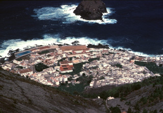 The town of Garachico on the northwestern coast of Tenerife Island occupies a lava delta created during an 18th-century eruption. The Garachico cinder cone, which was formed during the 1706 eruption, produced a 7-km-long lava flow that descended nearly 1400 m to the sea, destroying much of the village of Tanque as well as the town and port of Garachico. The Roque de Garachico island at the top of the photo predates the lava flow.
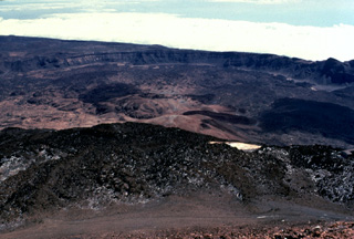 The arcuate rim of Las Cañadas caldera on Tenerife volcano in the Canary Islands rises in the distance above the flat-lying caldera floor. This view looks to the SE from the summit of Pico de Teide, a large stratovolcano constructed within the massive 10 x 17 km wide caldera. Dark-colored lava flows from Pico de Teide and other post-caldera cones mantle the caldera floor, which lies 300-m below the far caldera rim and 1700-m below the summit of Pico de Teide.
 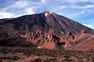 Pico de Teide towers above the Llanos de Ucanca plain on the floor of Las Cañadas caldera. The rocky spires in the foreground are eroded remains of intrusive phonolitic rocks of the Cañadas formation, predating formation of the caldera. Youthful dark-colored lava flows blanket the SW (left) side of Teide. The upper limit of the snowfield just below the summit of Teide marks the rim of the summit crater.
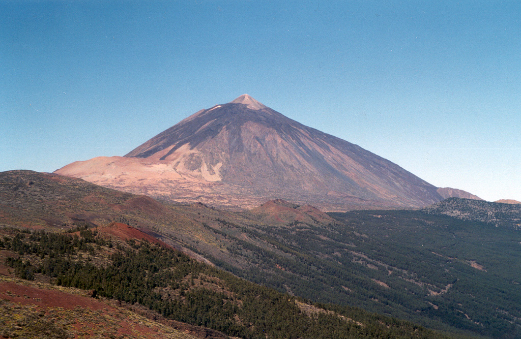
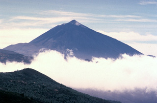 The 3715-m-high Teide stratovolcano, the highest peak in the Atlantic Ocean, dominates the island of Tenerife. Pico de Teide was constructed within the 10 x 17 km Las Cañadas caldera. The NE-trending Cordillera Dorsal volcanic massif joins the Las Cañadas volcano on the SW side of Tenerife with older volcanoes, creating the largest of the Canary Islands. Tenerife was observed in eruption by Christopher Columbus, and several other flank vents on the most active volcano of the Canary Islands have erupted during historical time.
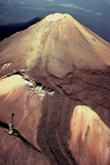 Trachytic lava flows with prominent lateral levees descend from the summit of Pico de Teide volcano and spill over the rim of an older crater. The pylon at the lower left and the building at left-center mark the upper part of an aerial cable car line that provides access to the 3715-m-high summit of Pico de Teide, the highest peak in the Atlantic Ocean.
 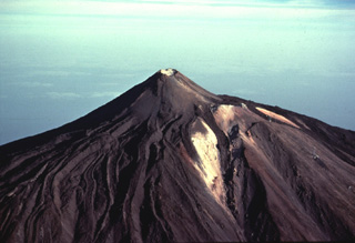 Steep-sided Pico de Teide rises to 3715 m on SW Tenerife Island. The summit cone is capped by a small 70-m-wide crater and was constructed within a larger crater, whose outer slopes form the light-colored areas at the right. A dramatic complex of overlapping obsidian-bearing lava flows with prominent levees descends from the summit and drapes the western flanks of the volcano. The age of the lava flows is not known, but they represent some of the most recent eruptive activity on Tenerife.
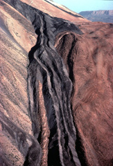 A dark-colored trachytic lava flow descends the flanks of Pico de Teide volcano on Tenerife Island in the Canary archipelago. The viscous obsidian-bearing lava flow displays steep-sided lateral levees. These define individual lobes that diverged around a high point on the surface of the flow. Another lava flow, one of many youthful flows erupted from Pico de Teide, forms the dark streak at the top center of the photo just below the skyline.
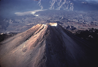 The summit of Pico de Teide volcano towers 1700 m above the floor of Las Cañadas caldera, whose southern caldera wall forms the craggy cliffs at the top of the photo. Fresh-looking unvegetated lava flows descend 7 km from the summit of Pico de Teide to the caldera wall, spreading across the light-colored sediments (upper left) on the broad caldera floor.
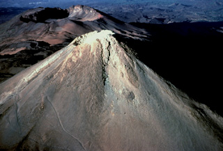 Pico de Teide, the highest peak in the Atlantic Ocean, towers 1700 m above the floor of Las Cañadas caldera. The small nearly circular, 70-m-wide Caldereta crater truncates the summit of Pico de Teide. The prominent 750-m-wide summit crater of Pico Viejo, another post-caldera stratovolcano, appears to the WSW beyond the summit of Pico de Teide.
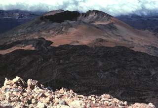 Fresh-looking lava flows, seen here from the summit of Pico de Teide, descend towards Pico Viejo (top center) and diverge to the north and south along a broad saddle between the two volcanoes. A 750-m-wide crater truncates the summit of Pico Viejo, which was formed contemporaneously with Pico de Teide. These two stratovolcanoes were constructed within the 10 x 17 km wide Las Cañadas caldera, whose floor is visible in the distance.
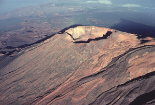 A prominent crater caps Pico Viejo, the second largest stratovolcano constructed within the massive Las Cañadas caldera. The sharp-peaked summit of the largest post-caldera volcano, Pico de Teide, casts a shadow (upper right) on the floor of the caldera. Dark-colored trachytic lava flows with prominent lateral levees descend at the lower right from the summit of Pico de Teide. A chain of youthful cinder cones, some of which erupted during historical time, occupies the caldera floor beyond Pico Viejo at the left.
 Teide volcano, the highest point on the island of Tenerife, towers above the scarp of the massive Orotava landslide, which occurred about 600,000 years ago. The light-colored area on the eastern foot of the volcano (left) is covered by tephra deposits from the Plinian Montana Blanca eruption about 2,000 years ago. Teide was constructed within the 10 x 16 km wide Las Cañadas caldera on the SW side of Tenerife. The large triangular island is composed of a complex of overlapping stratovolcanoes that have remained active into historical time.
The following 3 samples associated with this volcano can be found in the Smithsonian's NMNH Department of Mineral Sciences collections, and may be availble for research (contact the Rock and Ore Collections Manager). Catalog number links will open a window with more information.
| Catalog Number | Sample Description | Lava Source | Collection Date |
|---|---|---|---|
| NMNH 110021 | Basalt | -- | -- |
| NMNH 110022 | Phonolite | -- | -- |
| NMNH 110023 | Rhyolitic Obsidian | -- | -- |
| Copernicus Browser | The Copernicus Browser replaced the Sentinel Hub Playground browser in 2023, to provide access to Earth observation archives from the Copernicus Data Space Ecosystem, the main distribution platform for data from the EU Copernicus missions. |
| MIROVA | Middle InfraRed Observation of Volcanic Activity (MIROVA) is a near real time volcanic hot-spot detection system based on the analysis of MODIS (Moderate Resolution Imaging Spectroradiometer) data. In particular, MIROVA uses the Middle InfraRed Radiation (MIR), measured over target volcanoes, in order to detect, locate and measure the heat radiation sourced from volcanic activity. |
| MODVOLC Thermal Alerts | Using infrared satellite Moderate Resolution Imaging Spectroradiometer (MODIS) data, scientists at the Hawai'i Institute of Geophysics and Planetology, University of Hawai'i, developed an automated system called MODVOLC to map thermal hot-spots in near real time. For each MODIS image, the algorithm automatically scans each 1 km pixel within it to check for high-temperature hot-spots. When one is found the date, time, location, and intensity are recorded. MODIS looks at every square km of the Earth every 48 hours, once during the day and once during the night, and the presence of two MODIS sensors in space allows at least four hot-spot observations every two days. Each day updated global maps are compiled to display the locations of all hot spots detected in the previous 24 hours. There is a drop-down list with volcano names which allow users to 'zoom-in' and examine the distribution of hot-spots at a variety of spatial scales. |
|
WOVOdat
Single Volcano View Temporal Evolution of Unrest Side by Side Volcanoes |
WOVOdat is a database of volcanic unrest; instrumentally and visually recorded changes in seismicity, ground deformation, gas emission, and other parameters from their normal baselines. It is sponsored by the World Organization of Volcano Observatories (WOVO) and presently hosted at the Earth Observatory of Singapore.
GVMID Data on Volcano Monitoring Infrastructure The Global Volcano Monitoring Infrastructure Database GVMID, is aimed at documenting and improving capabilities of volcano monitoring from the ground and space. GVMID should provide a snapshot and baseline view of the techniques and instrumentation that are in place at various volcanoes, which can be use by volcano observatories as reference to setup new monitoring system or improving networks at a specific volcano. These data will allow identification of what monitoring gaps exist, which can be then targeted by remote sensing infrastructure and future instrument deployments. |
| Volcanic Hazard Maps | The IAVCEI Commission on Volcanic Hazards and Risk has a Volcanic Hazard Maps database designed to serve as a resource for hazard mappers (or other interested parties) to explore how common issues in hazard map development have been addressed at different volcanoes, in different countries, for different hazards, and for different intended audiences. In addition to the comprehensive, searchable Volcanic Hazard Maps Database, this website contains information about diversity of volcanic hazard maps, illustrated using examples from the database. This site is for educational purposes related to volcanic hazard maps. Hazard maps found on this website should not be used for emergency purposes. For the most recent, official hazard map for a particular volcano, please seek out the proper institutional authorities on the matter. |
| IRIS seismic stations/networks | Incorporated Research Institutions for Seismology (IRIS) Data Services map showing the location of seismic stations from all available networks (permanent or temporary) within a radius of 0.18° (about 20 km at mid-latitudes) from the given location of Tenerife. Users can customize a variety of filters and options in the left panel. Note that if there are no stations are known the map will default to show the entire world with a "No data matched request" error notice. |
| UNAVCO GPS/GNSS stations | Geodetic Data Services map from UNAVCO showing the location of GPS/GNSS stations from all available networks (permanent or temporary) within a radius of 20 km from the given location of Tenerife. Users can customize the data search based on station or network names, location, and time window. Requires Adobe Flash Player. |
| DECADE Data | The DECADE portal, still in the developmental stage, serves as an example of the proposed interoperability between The Smithsonian Institution's Global Volcanism Program, the Mapping Gas Emissions (MaGa) Database, and the EarthChem Geochemical Portal. The Deep Earth Carbon Degassing (DECADE) initiative seeks to use new and established technologies to determine accurate global fluxes of volcanic CO2 to the atmosphere, but installing CO2 monitoring networks on 20 of the world's 150 most actively degassing volcanoes. The group uses related laboratory-based studies (direct gas sampling and analysis, melt inclusions) to provide new data for direct degassing of deep earth carbon to the atmosphere. |
| Large Eruptions of Tenerife | Information about large Quaternary eruptions (VEI >= 4) is cataloged in the Large Magnitude Explosive Volcanic Eruptions (LaMEVE) database of the Volcano Global Risk Identification and Analysis Project (VOGRIPA). |
| EarthChem | EarthChem develops and maintains databases, software, and services that support the preservation, discovery, access and analysis of geochemical data, and facilitate their integration with the broad array of other available earth science parameters. EarthChem is operated by a joint team of disciplinary scientists, data scientists, data managers and information technology developers who are part of the NSF-funded data facility Integrated Earth Data Applications (IEDA). IEDA is a collaborative effort of EarthChem and the Marine Geoscience Data System (MGDS). |

