Fiji Volcanoes
A map display is currently under development.
Fiji has 2 Holocene volcanoes. Note that as a scientific organization we provide these listings for informational purposes only, with no international legal or policy implications. Volcanoes will be included on this list if they are within the boundaries of a country, on a shared boundary or area, in a remote territory, or within a maritime Exclusive Economic Zone. Bolded volcanoes have erupted within the past 20 years. Suggestions and data updates are always welcome ().
| Volcano Name | Last Eruption | Volcanic Region | Primary Landform |
|---|---|---|---|
| Nabukelevu | 1660 CE | Fiji Volcanic Arc | Minor (Silicic) |
| Taveuni | 1550 CE | Fiji Volcanic Arc | Shield |
Chronological listing of known Holocene eruptions (confirmed or uncertain) from volcanoes in Fiji. Bolded eruptions indicate continuing activity.
| Volcano Name | Start Date | Stop Date | Certainty | VEI | Evidence |
|---|---|---|---|---|---|
| Nabukelevu | 1660 ± 30 years | Unknown | Confirmed | Isotopic: 14C (calibrated) | |
| Taveuni | 1550 ± 100 years | Unknown | Confirmed | 0 | Isotopic: 14C (calibrated) |
| Taveuni | 1420 ± 20 years | Unknown | Confirmed | 0 | Isotopic: 14C (calibrated) |
| Taveuni | 1350 ± 75 years | Unknown | Confirmed | 2 | Correlation: Tephrochronology |
| Taveuni | 1160 ± 150 years | Unknown | Confirmed | 2 | Isotopic: 14C (calibrated) |
| Taveuni | 1020 (?) | Unknown | Confirmed | 2 | Correlation: Tephrochronology |
| Taveuni | 0880 (?) | Unknown | Confirmed | 2 | Correlation: Tephrochronology |
| Taveuni | 0770 (?) | Unknown | Confirmed | 2 | Correlation: Tephrochronology |
| Taveuni | 0640 ± 40 years | Unknown | Confirmed | 2 | Isotopic: 14C (calibrated) |
| Taveuni | 0520 ± 100 years | Unknown | Confirmed | 2 | Isotopic: 14C (calibrated) |
| Taveuni | 0480 ± 75 years | Unknown | Confirmed | 2 | Isotopic: 14C (calibrated) |
| Taveuni | 0400 ± 50 years | Unknown | Confirmed | 2 | Isotopic: 14C (calibrated) |
| Taveuni | 0350 (?) | Unknown | Confirmed | 2 | Correlation: Tephrochronology |
| Nabukelevu | 0340 (?) | Unknown | Confirmed | Isotopic: 14C (calibrated) | |
| Taveuni | 0320 ± 100 years | Unknown | Confirmed | 2 | Isotopic: 14C (calibrated) |
| Taveuni | 0270 (?) | Unknown | Confirmed | 1 | Correlation: Tephrochronology |
| Taveuni | 0220 ± 100 years | Unknown | Confirmed | 0 | Isotopic: 14C (calibrated) |
| Taveuni | 0090 BCE ± 200 years | Unknown | Confirmed | 2 | Isotopic: 14C (calibrated) |
| Taveuni | 0200 BCE (?) | Unknown | Confirmed | 2 | Correlation: Tephrochronology |
| Taveuni | 0330 BCE ± 75 years | Unknown | Confirmed | 2 | Isotopic: 14C (calibrated) |
| Taveuni | 0400 BCE ± 20 years | Unknown | Confirmed | 2 | Isotopic: 14C (calibrated) |
| Nabukelevu | 0580 BCE ± 300 years | Unknown | Confirmed | Isotopic: 14C (calibrated) | |
| Taveuni | 0600 BCE (?) | Unknown | Confirmed | 2 | Correlation: Tephrochronology |
| Taveuni | 0680 BCE (?) | Unknown | Confirmed | 2 | Correlation: Tephrochronology |
| Taveuni | 1020 BCE (?) | Unknown | Confirmed | 2 | Correlation: Tephrochronology |
| Taveuni | 1100 BCE (?) | Unknown | Confirmed | 2 | Correlation: Tephrochronology |
| Taveuni | 1200 BCE (?) | Unknown | Confirmed | 2 | Correlation: Tephrochronology |
| Taveuni | 1300 BCE (?) | Unknown | Confirmed | 2 | Correlation: Tephrochronology |
| Taveuni | 1450 BCE (?) | Unknown | Confirmed | 2 | Correlation: Tephrochronology |
| Taveuni | 1700 BCE (?) | Unknown | Confirmed | 2 | Correlation: Tephrochronology |
| Taveuni | 3200 BCE ± 150 years | Unknown | Confirmed | 2 | Isotopic: 14C (calibrated) |
| Taveuni | 3580 BCE ± 200 years | Unknown | Confirmed | 2 | Isotopic: 14C (calibrated) |
| Taveuni | 4800 BCE ± 100 years | Unknown | Confirmed | 2 | Isotopic: 14C (calibrated) |
| Taveuni | 5230 BCE ± 100 years | Unknown | Confirmed | 2 | Isotopic: 14C (calibrated) |
| Taveuni | 5920 BCE ± 75 years | Unknown | Confirmed | 2 | Isotopic: 14C (calibrated) |
| Taveuni | 6560 BCE ± 75 years | Unknown | Confirmed | 2 | Isotopic: 14C (calibrated) |
| Taveuni | 8040 BCE ± 50 years | Unknown | Confirmed | 2 | Isotopic: 14C (calibrated) |
Fiji has 6 Pleistocene volcanoes. Note that as a scientific organization we provide these listings for informational purposes only, with no international legal or policy implications. Volcanoes will be included on this list if they are within the boundaries of a country, on a shared boundary or area, in a remote territory, or within a maritime Exclusive Economic Zone. Suggestions and data updates are always welcome ().
There are 5 photos available for volcanoes in Fiji.
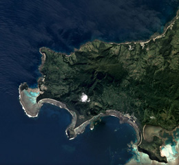 The Nabukelevu lava-dome complex formed at the SW end of Kadavu Island at the S end of the Fiji archipelago, and is shown in this May 2019 Planet Labs satellite image monthly mosaic (N is at the top; this image is approximately 10 km across). The complex has produced several debris avalanche deposits through flank collapse and block-and-ash flow deposits from dome collapse.
Satellite image courtesy of Planet Labs Inc., 2019 (https://www.planet.com/).
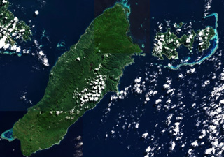
 The 16 x 9 km Koro Island is located between Fiji's two major island groups. A chain of scoria cones of late-Pleistocene or possibly Holocene age extends along the crest of the island from the NE tip (upper right) to the southern tip. The youngest lava flows are mostly confined to the plateau in the center of the island.
 NASA Space Shuttle image STS111-719-74, 2002 (http://eol.jsc.nasa.gov/).
 Taveuni Island in Fiji is situated along a larger ridge and is approximately 40 km long, shown in this composite image of Sentinel-2 (3 and 6 July) and Landsat 8 (1 July) 2019 images courtesy of Planet Labs (N is at the top). Around 150 vents are aligned along the length of the NW-SE oriented island. The Lake Tagimoucea Basin rift zone is about one-third of the way down and contains lavas offset by faulting.
Satellite image courtesy of Planet Labs Inc., 2019 (https://www.planet.com/).
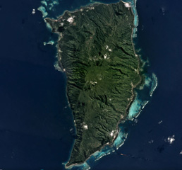 The 17-km-long Koro Island in Fiji is located between Viti Levu and Vanua Levu Islands, and is shown in this May 2018 Planet Labs satellite image mosaic (N is at the top). Late Pleistocene or possibly Holocene age scoria cones formed along the crest of the island, and younger lava flows are in the central plateau.
Satellite image courtesy of Planet Labs Inc., 2018 (https://www.planet.com/).
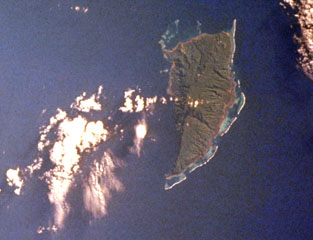
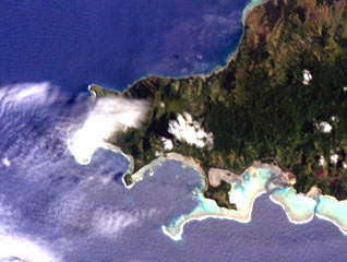 The summit of Nabukelevu lies between the two clouds near the center of this NASA International Space Station image and is located at the SW end of Kadavu Island at the southern end of the Fiji archipelago. Debris avalanches from collapse of the Mt. Washington lava dome complex reached both the northern coast to the right of Cape Washington (the small peninsula at the upper left) and horseshoe-shaped Daviqele Bay (bottom center) and the south. Block-and-ash flows from dome growth and collapse have occurred within the past few hundred years.
NASA International Space Station image ISS006-E-7466, 2002 (http://eol.jsc.nasa.gov/).
This is a compilation of Fiji volcano information sources, such as official monitoring or other government agencies.
| Volcanic Ash Advisory Center | |
|---|---|
| Wellington Volcanic Ash Advisory Center (VAAC) | |
| - Wellington VAAC Notices | |