Report on Nyiragongo (DR Congo) — March 2002

Bulletin of the Global Volcanism Network, vol. 27, no. 3 (March 2002)
Managing Editor: Richard Wunderman.
Nyiragongo (DR Congo) Report of field work; MODIS imagery from January 2002 eruption
Please cite this report as:
Global Volcanism Program, 2002. Report on Nyiragongo (DR Congo) (Wunderman, R., ed.). Bulletin of the Global Volcanism Network, 27:3. Smithsonian Institution. https://doi.org/10.5479/si.GVP.BGVN200203-223030
Nyiragongo
DR Congo
1.52°S, 29.25°E; summit elev. 3470 m
All times are local (unless otherwise noted)
During 17-18 January 2002 Nyiragongo, located ~18 km N of Lake Kivu in the Democratic Republic of Congo (DRC) close to the border of Rwanda, erupted an estimated 20 x 106 m3 volume of lava (BGVN 26:12). Lava flows originated from the central crater and from several locations along a huge system of fractures that rapidly developed along the entire S flank of the volcano down to the city of Goma (~400,000 people) on the N shore of Lake Kivu. Goma was then invaded by extensive lava flows, which destroyed at least 13% of the surface of the city before reaching the lake. The advancing lava flows caused the spontaneous evacuation of at least 300,000 people, mostly toward the neighboring town of Gisenyi in Rwanda, and left more than 40,000 people homeless. About 100 people died as a consequence (direct or indirect) of the eruption. This disaster required an urgent public health response to evaluate the hazards to life and health. The assessment was especially important because of the humanitarian crisis in the eastern DRC that led many of the people who had fled from the lava flows to return to the city within one or two days, despite the danger of further eruptive activity or the possible risks arising from the proximity of the cooling lava flows (Baxter, 2002).
The following report, with the exception of the Moderate Resolution Imaging Spectroradiometer (MODIS) imagery, was compiled from field visits carried out by the volcanologists representing the United Nations Office for the Coordination of Human Affairs (UN-OCHA): Dario Tedesco, Paolo Papale, Orlando Vaselli, and Jacques Durieux. The team flew over the volcano and Goma in a helicopter on 22 and 24 January, and made field observations during 23 January-4 February. One team member continued studies on Lake Kivu until 13 February. The report provides an initial reconstruction of the main events of the eruption based on reports from local witnesses, observations and reports by researchers at the Goma Volcano Observatory (GVO), a closer inspection of seismograms recorded by GVO seismic stations, and field work by the UN-OCHA team. The UN-OCHA team worked closely with a French-British team of scientists (Patrick Allard, Peter Baxter, Michel Halbwachs, and Jean-Christophe Komorowski), whose report (Allard and others, 2002) will be summarized in a future Bulletin.
Activity during December 2000-January 2002. Since December 2000 the two GVO seismic stations had recorded long-period (LP) earthquake swarms. Commonly, each LP event was shortly followed by volcanic tremor.
On 6 February 2001 Nyamuragira erupted (BGVN 26:01). Following the 2-week eruption, seismicity did not decrease. On the contrary, volcanic tremor and LP earthquakes reappeared at both stations (Bulengo, BSS, S of Nyiragongo and Katale, KSS, NE of Nyiragongo, ~40 km from Bulengo), without showing any particular pattern, from March 2001 through January 2002. During the 10 months that preceded the January 2002 eruption, it was impossible to distinguish which volcano was the source of the seismicity.
In addition to the increased seismic activity, on 5 October strong vibrations were felt and on 7 October a strong tectonic earthquake (M 3.5-4.0), unusual for this region, was felt by the population. This earthquake was followed a few hours later by high-amplitude volcanic tremor.
Field trips by GVO personnel to the summit of Nyiragongo during 29 October-1 November and 8-10 December 2001 revealed several important changes. Immediately after the October tectonic event a white plume was visible inside the 1977 eruptive fracture on top of and inside the Shaheru crater (2 km S of the summit crater) at 2,700 m elevation. A similar plume was emerging from new cracks in the inner wall of the central crater, while a dark plume was visible from the small 1995 spatter cone inside the volcano. The new fumaroles on the side of the small central crater had a temperature of 70°C; the ground temperature, which was normally at 5-9°C, was recorded as 28°C; cracks near Shaheru crater were at ~50°C.
An increase in seismicity similar to that observed during early October occurred beginning on 4 January 2002, when an M > 4 earthquake occurred. On 7 January seismic activity triggered some visible changes, including reactivation of fumarolic activity. Following the 4 January earthquake seismicity remained high until 16 January. The onset of the eruption was preceded by about 8 hours of calm consisting of very low seismicity (without tremor or LP earthquakes).
Eruption during 17-18 January 2002. Early on 17 January a huge system of fractures began to develop on the S flank and eventually extended from high elevations down to Goma and Lake Kivu. The main trend of fractures was N15°W, which is similar to the general trend of the rift valley in the Nyiragongo region. The system of fractures appears to have propagated down from the volcano, starting at 2,800-3,000 m elevation (300-400 m N of the old Shaheru crater), and covering a distance of ~10 km towards Goma in less than 8 hours. The uppermost portion of the fracture started erupting at 0835 on 17 January. A single fracture ~2 m wide was visible above and inside Shaheru. Reactivated during the January event, it corresponded to the eruptive fracture of January 1977. Below the Shaheru crater the fracture was replaced by a more complex system, with two parallel main fractures ~300 m apart, also propagating N15°W. At about 1000 the system of fractures had reached ~1,900 m elevation; they then took ~30 minutes to cross the last system of ancient cones N of Goma, at ~1,700 m. By about 1400 the fractures were in the proximity of the Munigi village on the outskirts of Goma.
As the fractures advanced, several started erupting. Beginning around 1000 and lasting for at least two hours, lava flows escaped at ~1,950-2,000 m elevation S of the ancient Kanyambuzi-Mudjoga tuff cones. Fractures on the gentle slopes N of Goma lacked venting lava along a portion a few kilometers in length, but, at several locations the tips of intruded dykes ascended within only a few ten's of centimeters to a few meters below the ground surface.
At 1610 on 17 January the southernmost system of vents opened S of Munigi village and on the outskirts of Goma at 1,570-1,580 m elevation. Lava flows from these vents affected the Goma airport and destroyed part of the city before reaching the lake. About 10-20 minutes later a new N15°W-oriented fracture began to erupt at 1,950-2,000 m elevation, located ~1.5 km W of the main fracture system. Lava flows from this fracture partially destroyed the western part of Goma without reaching the lake.
Around the same time a fracture a few hundred meters long opened on the NW flank of the cone, at ~2,700-3,000 m elevation as estimated by helicopter, producing a lava flow that did not affect inhabited areas. Unlike the southern fracture system, this fracture had an estimated N30°E to N60°E trend. The eruptive activity at several places along the fracture system on the S flank reportedly lasted through part of the night or even up to daylight on 18 January.
MODIS images on 18, 21, and 27 January showed a hot spot in the vicinity of the volcano (figure 13). The 18 January image showed a single, large hot spot (3-4 pixels wide and ~11 pixels long on the S flank of Nyiragongo. The elongate hot spot had a NNE-SSW orientation. Its proximal section was located about mid-way up the S flank of the volcano (in the vicinity of the Shaheru-Djoga cinder cones and 1977 S-flank fissure) and the distal section was directly over Goma. The hot spot decreased over the following days, and by 27 January was barely visible.
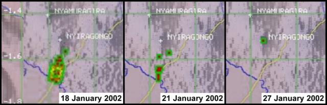 |
Figure 13. Moderate Resolution Imaging Spectroradiometer (MODIS) satellite images on 18, 21, and 27 January showing a hot spot near Nyiragongo during the eruption. The 18 January image shows a single, large hot spot (3-4 pixels wide and ~ 11 pixels long) on the S flank. The hot spot decreased over the following days, and by 27 January was barely visible. Courtesy HIGP/SOEST. |
Activity following the eruption. During the night of 21 January some earthquake swarms created panic in the population. During about 0600-1800 on 22 January no earthquakes were felt. However, at about 1800 a sequence began during which ~20 earthquakes were felt in less than 3 hours. The following days were characterized by periods of intense seismicity, alternating with intervals (~10-15 hours) of lower seismic activity.
Seismic events showed quite a range of magnitude, frequency content, and S-P times, suggesting several different origins. The earthquakes that occurred in the days following the eruption were ~M > 5. During the 5 days following the eruption ~100 tectonic earthquakes (M > 3.5) occurred with epicenters in the Goma-Nyiragongo region. Several houses collapsed or were seriously damaged due to seismic loading in Gisenyi, where nine people died as a direct result of roof collapse. Seismic signals showed a typical sequence of tectonic events, followed within minutes to hours by LP events and volcanic tremor lasting continuously for more than 10 hours. Such a sequence, which is identical to the typical sequence recorded during the year preceding the eruption, suggested rock fracturing followed by the intrusion and ascent of magma.
An estimate of the location of seismic events made by comparing the arrival time differences of P- and S-waves at the three seismic stations of Bulengo, Katale, and Goma (the last one provided by the French-British team) showed that on 27 and 28 January the shocks were concentrated in the area between the Nyiragongo crater and Goma, probably 4-6 km N of Lake Kivu. During the first days of February the epicenters of earthquakes were clustered in two areas. The first was along the system of fractures, stretching a few kilometers N and S of Goma (in part, beneath Lake Kivu). The second cluster lay S of the town of Sake, 15-20 km W of Goma, close to the W border of the rift.
Observations during a helicopter flight over the volcano on 21 January revealed that the crater floor (old surface of the 1994-95 lava lake) was cut by a N-S elongated depression (like a small graben) underlain by steaming cracks. The next day witnesses from villages 6 km SW and ~10 km N of the summit crater reported that at about 2100 an earthquake was felt and immediately followed by a red glow or "flames" above the crater. Later that evening fine ash fell along the road from Goma to Sake. On the morning of 23 January ash fell in Goma and at the airport. A helicopter survey revealed a layer of ash on the volcano's upper S and E flanks and devastated vegetation on the crater's N flank.
On 24 January the inside of the crater appeared as a huge cavity with an estimated depth of 800 m and a grayish-yellow colored floor. The old terraces that represented the remnants of the lava lake at different stages of its long history were nearly totally absent. The interpretation is that either the emptying of the lava lake, the fracturing of the system, or more likely both, destabilized the inner part of the crater. Seismic records showed higher-amplitude tremor, presumably related to the crater-floor collapses, starting on 22 January at 2051 and lasting for ~4 hours. During the same flight on 24 January an explosion or a new collapse at the crater produced a small cloud of steam and ash that reached a few hundred meters above the crater rim.
Gas blasts sporadically occurred, mainly after the eruption, ~100-200 m away from the main path of the lava flow in Goma causing displacement of pavement in small buildings. In a small garage in Goma a thick (~10 cm) concrete pavement was cracked and uplifted up to 50-70 cm by the gas blasts.
Observations and research at Lake Kivu. Interesting phenomena were noted on the shore of Lake Kivu in the area of Himbi. Women who used to wash clothes close to the lake observed that the water level had decreased a few centimeters 3-5 days before the eruption. During the night and early morning of 17-18 January waiters at a restaurant observed crabs and crayfish jumping out of the lake. During 20-21 January dead fish and bubbling spots were observed in the small bay close to the restaurant. Waiters stated that the temperature of the lake in those zones had increased and a brown-black stain appeared from the bottom of the lake in an area of several square meters. At the same time an odor of spoiled eggs (suggesting presence of H2S) was present. A similar phenomenon occurred early in the morning (at about 0230) on 30 January after an M 4.5 earthquake. The owners of the restaurant suddenly awoke due to difficulty breathing and the strong smell of rotten eggs. In both cases, the "normal" conditions were reestablished in a "short" (not well-defined) time. Soil-gas measurements indicated that CO2 concentrations reached values up to 20%.
A geochemical survey of the main fluid manifestations in and around the S part of Nyiragongo was carried out during the days after the 17 January eruption. Sampling included water from Lake Kivu, cold and thermal springs, dry vents, and soil gases. The main conclusions of this survey were: 1) contrary to rumors following the entry of lava flows into the lake, lake water only a few meters away from the lava front was not polluted; 2) the geochemical characteristics of water from the lake and from springs on land are close to those found previously by Tietze and others (1980) and Tuttle and others (1990); and 3) the analyzed gases appear to have a clear magmatic origin as revealed by their isotopic signature. An exception to the final conclusion is that gases from the Rambo sampling point, which sits next to a brewery in Gisenyi, appear to represent mixtures between biogenic (organic) and magmatic sources.
Immediately following the eruption, fishermen reported visible changes in the water level at Lake Kivu. This was confirmed by women who visited the lake shore daily for washing or collecting water. A series of measurements was started in close cooperation with the UN field officer Dominic Garcin, who has a vast knowledge of the lake. The first measurements were obtained on 28 January along the shoreline from Gisenyi to Sake. The results confirmed a significant subsidence of the ground and rise of the water level. The subsidence was highest (37 cm) in Goma, then progressively vanished towards the E (~10 cm in Gisenyi but 0 cm ~2 km farther E) and W (0 cm ~15 km W of Goma). After these first measurements, several others were systematically taken along the N shoreline of Lake Kivu as well as around the lake up to ten's of kilometers S of Goma, and at Idjwi Island, ~30 km S of Goma. The measurements showed that ground subsidence is an ongoing phenomenon in the entire rift area near Lake Kivu. One month after the eruption, maximum measured ground subsidence was 50-60 cm at the Goma harbor and at Idjwi Island (figure 14). Scientists note that the February-March westward shifting of the ground subsidence corresponds to a similar westward shifting of epicenters.
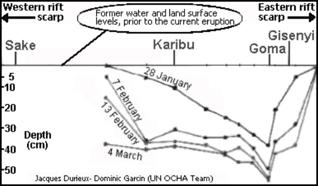 |
Figure 14. Plots showing cumulative, asymmetrical land subsidence in the Goma area across the far S flanks of Nyiragongo. The subsidence was measured with respect to pre-subsidence surface of Lake Kivu, and surveyed along an E-W transect. The four survey dates (all in early 2002) each established the greatest subsidence at Goma, and lesser subsidence towards the East African rift's margins. Courtesy UN-OCHA team. |
Conclusions. The characteristics of the erupted products and associated lava flows, together with the available information on the state of the volcano prior the eruption, suggest different dynamics of magma emission in the upper and lower portions of the fracture system. Two different interpretations have been offered. The "magmatic" hypothesis is that the energy for intense fracturing of the volcanic apparatus came from deep magma pushing from below inside the volcanic system. The "tectonic" hypothesis is that the energy for fracturing came from a non-volcanic source and was due to a rifting event related to regional tectonics. Further discussion of both hypotheses is offered in the report by the UN-OCHA team (Tedesco and others, 2002).
Goma is considered at a very high risk should reactivation of the volcano and rift system occur. The security of its inhabitants cannot be guaranteed even with the most sophisticated instrumental network. Thousands of lives can be saved by increased surveillance, continued scientific investigation, contingency plans, and information campaigns.
An outstanding effort by the UN and several donors allowed for the development of short and long-term aid to the Goma Volcano Observatory (GVO). This effort included support for foreign volcanologists, purchase of new equipment, establishing a new monitoring network, and help with logistics (transportation, communications, salaries, etc.). GVO is now publishing weekly reports on volcano activities.
References. Allard, P., Baxter, P., Halbwachs, M., and Komorowski, J-C, 2002, Final report of the French-British scientific team: submitted to the Ministry for Foreign Affairs, Paris, France, Foreign Office, London, United Kingdom and respective Embassies in Democratic Republic of Congo and Republic of Rwanda, 24 p.
Baxter, P.J., 2002, Eruption at Nyiragongo volcano, Democratic Republic of Congo, 17-18 January 2002: a report on a field visit to assess the initial hazards of the eruption, 15 p.
Tedesco, D., Papale, P., Vaselli, O., and Durieux, J., 2002, The January 17th, 2002 eruption of Nyiragongo, Democratic Republic of Congo: UN-OCHA report, 17 p.
Tietze, K., Geyh, M., Muller, H., Schroder, L. Stahl, W., and Wehner, H., 1980, Geol. Rund., v. 69, p. 452-472.
Tuttle, M.L., Lockwood, J.P., and Evans, W.C., 1990, Natural hazards associated with Lake Kivu in Rwanda and Zaire, central Africa: U.S. Geological Survey, Open File Report 90-691, 47 p.
General Reference. Tazieff, H., 1979, Nyiragongo, the forbidden volcano, translated by J. F. Bernard: Barron's, New York, 287 p. Originally published as Nyiragongo: Flammarion, Paris, 1975.
Geological Summary. The Nyiragongo stratovolcano contained a lava lake in its deep summit crater that was active for half a century before draining catastrophically through its outer flanks in 1977. The steep slopes contrast to the low profile of its neighboring shield volcano, Nyamuragira. Benches in the steep-walled, 1.2-km-wide summit crater mark levels of former lava lakes, which have been observed since the late-19th century. Two older stratovolcanoes, Baruta and Shaheru, are partially overlapped by Nyiragongo on the north and south. About 100 cones are located primarily along radial fissures south of Shaheru, east of the summit, and along a NE-SW zone extending as far as Lake Kivu. Many cones are buried by voluminous lava flows that extend long distances down the flanks, which is characterized by the eruption of foiditic rocks. The extremely fluid 1977 lava flows caused many fatalities, as did lava flows that inundated portions of the major city of Goma in January 2002.
Information Contacts: Dario Tedesco, Dipartimento Scienze Ambientali, Seconda Universita' di Napoli, Via Vivaldi 43, 81100 Caserta, Italy; Paolo Papale, Istituto Nazionale di Geofisica e Vulcanologia, via S. Maria, 53, I-56126 Pisa, Italy; Orlando Vaselli, Dipartimento Scienze della Terra, via G. La Pira, 4, 50121 Firenze, Italy; Jacques Durieux, Groupe d'Etude des Volcans Actifs, 6, Rue des Razes 69320 Feyzin, France; Dieudonné Wafula, Goma Volcano Observatory, Departement de Geophysique, Centre de Recherche en Sciences Naturelles, Lwiro, D.S. Bukavu, DRC; Andy Harris, Eric Pilger and Luke Flynn, Hawaii Institute of Geophysics and Planetology at the School of Ocean and Earth Science Technology (HIGP/SOEST), University of Hawaii, 2525 Correa Road, Honolulu, HI 96822 USA; Peter Baxter, Department of Community Medicine, Institute of Public Health, University of Cambridge, University Forvie Site, Robinson Way, Cambridge, CB2 2SR, United Kingdom.