Report on Witori (Papua New Guinea) — September 2013
Bulletin of the Global Volcanism Network, vol. 38, no. 9 (September 2013)
Managing Editor: Richard Wunderman.
Witori (Papua New Guinea) Explosive ash plumes reported in May-July 2012
Please cite this report as:
Global Volcanism Program, 2013. Report on Witori (Papua New Guinea) (Wunderman, R., ed.). Bulletin of the Global Volcanism Network, 38:9. Smithsonian Institution. https://doi.org/10.5479/si.GVP.BGVN201309-252080
Witori
Papua New Guinea
5.5745°S, 150.5161°E; summit elev. 724 m
All times are local (unless otherwise noted)
Based on analyses of satellite images as reported by the Global Disaster Alert and Coordination System (GDACS) and the Darwin Volcanic Ash Advisory Centre (VAAC), five volcano plume advisories were issued for Pago volcano in the Summer of 2012 (table 1).
Table 1.Five VAAC volcano ash advisories were issued for Pago volcano for the period May-July 2012. Darwin VAAC Aviation Alert Colors range in four steps from green to yellow to orange to red - lowest to highest alert. Courtesy of Darwin VAAC and GDACS.
| Date – Time, 2012, UTC | VAAC Aviation Alert Color | Other Observations |
| 3 May – 0530 | Red | high level eruption to 12.2 km |
| 3 May – 0600 | Red | high level eruption to 13.7 km extending 74 km to NE |
| 3 May – 0715 | Orange | ash/steam plume to 13.7 km extending 74 km to NE |
| 10 Jul – 1630 | Orange | ash plume to 4.3 km extending 280 km SW |
| 10 Jul – 2203 | Orange | ash plume to 4.3 km extending 185 km SW |
According to the Papua New Guinea (PNG) National Disaster Centre (2013), PNG has 16 active and at least 28 potentially active or 'dormant' volcanoes which are a potential danger to the lives of about a quarter of a million people living in a total area of 16, 000 km2. Of the 16 active volcanoes, 6 of them are classified as high-risk volcanoes - high-risk in the sense that they have had explosive eruptions in the past and have the potential of repeating these eruptions in future. Of these 6 high-risk volcanoes, 3 are in New Britain - Rabaul in East New Britain, and Ulawun and Pago in West New Britain (for locations, see figure 3, BGVN 32:04, on Sulu Range volcano).
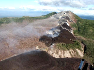
Figure 20 shows a satellite photo of approximately 8-km diameter Witori caldera from Google Earth. The walls of the caldera appear on the N and NW side of the caldera. A series of lava flows have formed the lobate character of the floor of the caldera. More detail on the lava flows appear in a previous report on Pago (figure 3, BGVN 27:08 - a vertical photo, with the old caldera rim delineated in white, distribution of new lava flows from August 2002 shown in red, compared with the previous lava flows from the 1911-18 eruption shown in light blue; a fault perpendicular to the 2002 lava flow is shown in dark blue).
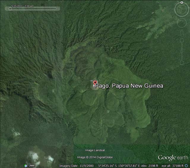 |
Figure 20. Satellite photo of Witori caldera within which Pago volcano exists. Courtesy of Google Earth. |
References. Volcano Research Center, 2002 (4 September), Pago volcano, New Britain, Papua, New Guinea: Brief report and Photographs Aug. 26-September 2, 2002; URL:http://hakone.eri.u-tokyo.ac.jp.
Papua New Guinea (PNG) National Disaster Centre (NDC), 2013 (28 July), Volcanic eruption, PGN NDC (URL:http://www.pngndc.gov.pg/).
Geological Summary. The active Pago cone has grown within the Witori caldera (5.5 x 7.5 km) on the northern coast of central New Britain contains the active Pago cone. The gently sloping outer caldera flanks consist primarily of dacitic pyroclastic-flow and airfall deposits produced during a series of five major explosive eruptions from about 5,600 to 1,200 years ago, many of which may have been associated with caldera formation. Pago cone may have formed less than 350 years ago; it has grown to a height above the caldera rim, and a series of ten dacitic lava flows from it covers much of the caldera floor. The youngest of these was erupted during 2002-2003 from vents extending from the summit nearly to the NW caldera wall. The Buru caldera cuts the SW flank.
Information Contacts: Ima Itikarai and Herman Patia, Rabaul Volcano Observatory (RVO), P.O. Box 386, Rabaul, Papua New Guinea; Darwin Volcanic Ash Advisory Centre (VAAC), Bureau of Meteorology, Northern Territory Regional Office, PO Box 40050, Casuarina, NT 0811, Australia (URL: http://www.bom.gov.au/info/vaac/); Global Disaster Alert and Coordination System (GDACS), United Nations and the European Commission (URL: http://www.gdacs.org/Volcanoes); Volcano Research Center, Earthquake Research Institute, University of Tokyo, 113-0032 1-1-1, Yayoi, Bunkyo-ku, Tokyo (URL: http://hakone.eri.u-tokyo.ac.jp); and Papua New Guinea (PNG) National Disaster Centre (URL: http://www.pngndc.gov.pg/).