Report on Nyiragongo (DR Congo) — December 2019

Bulletin of the Global Volcanism Network, vol. 44, no. 12 (December 2019)
Managing Editor: Edward Venzke.
Edited by Kadie L. Bennis. Research and preparation by Paul Berger.
Nyiragongo (DR Congo) Lava lake persists during June-November 2019
Please cite this report as:
Global Volcanism Program, 2019. Report on Nyiragongo (DR Congo) (Bennis, K.L., and Venzke, E., eds.). Bulletin of the Global Volcanism Network, 44:12. Smithsonian Institution. https://doi.org/10.5479/si.GVP.BGVN201912-223030
Nyiragongo
DR Congo
1.52°S, 29.25°E; summit elev. 3470 m
All times are local (unless otherwise noted)
Nyiragongo is a stratovolcano with a 1.2 km-wide summit crater containing an active lava lake that has been present since at least 1971. It is located the Virunga Volcanic Province (VVP) in the Democratic Republic of the Congo, part of the western branch of the East African Rift System. Typical volcanism includes strong and frequent thermal anomalies, primarily due to the lava lake, incandescence, gas-and-steam plumes, and seismicity. This report updates activity during June through November 2019 with the primary source information from monthly reports by the Observatoire Volcanologique de Goma (OVG) and satellite data.
In the July 2019 monthly report, OVG stated that the lava lake level had dropped during the month, with incandescence only visible at night (figure 68). In addition, the small eruptive cone within the crater, which has been active since 2014, decreased in activity during this timeframe. A MONUSCO (United Nations Stabilization Mission in the Democratic Republic of the Congo) helicopter overflight took photos of the lava lake and observed that the level had begun to rise on 27 July. Seismicity was relatively moderate throughout this reporting period; however, on 9-16 July and 21 August strong seismic swarms were recorded.
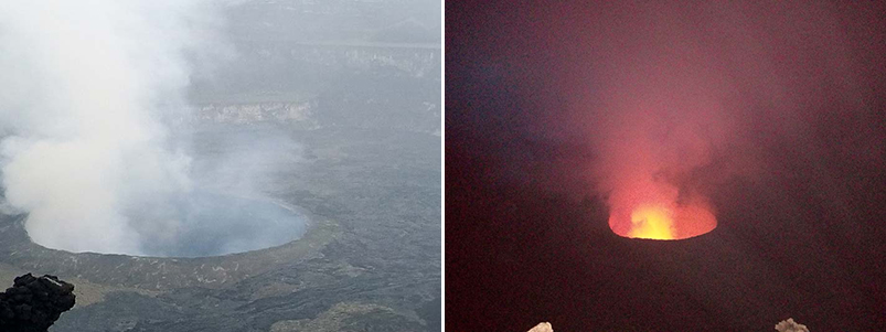 |
Figure 68. Webcam images of Nyiragongo on 20 July 2019 where incandescence is not visible during the day (left) but is observed at night (right). Incandescence is accompanied by gas-and-steam emissions. Courtesy of OVG. |
MIROVA (Middle InfraRed Observation of Volcanic Activity) analysis of MODIS satellite data continued to show frequent and strong thermal anomalies within 5 km of the crater summit through November 2019 (figure 69). Similarly, the MODVOLC algorithm reported almost daily thermal hotspots (more than 600) within the summit crater between June 2019 through November. These data are corroborated with Sentinel-2 thermal satellite imagery and a photo from OVG on 19 December 2019 showing the active lava lake (figures 70 and 71).
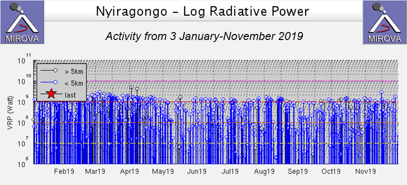 |
Figure 69. Thermal anomalies at Nyiragongo from 3 January through November 2019 as recorded by the MIROVA system (Log Radiative Power) were frequent and strong. Courtesy of MIROVA. |
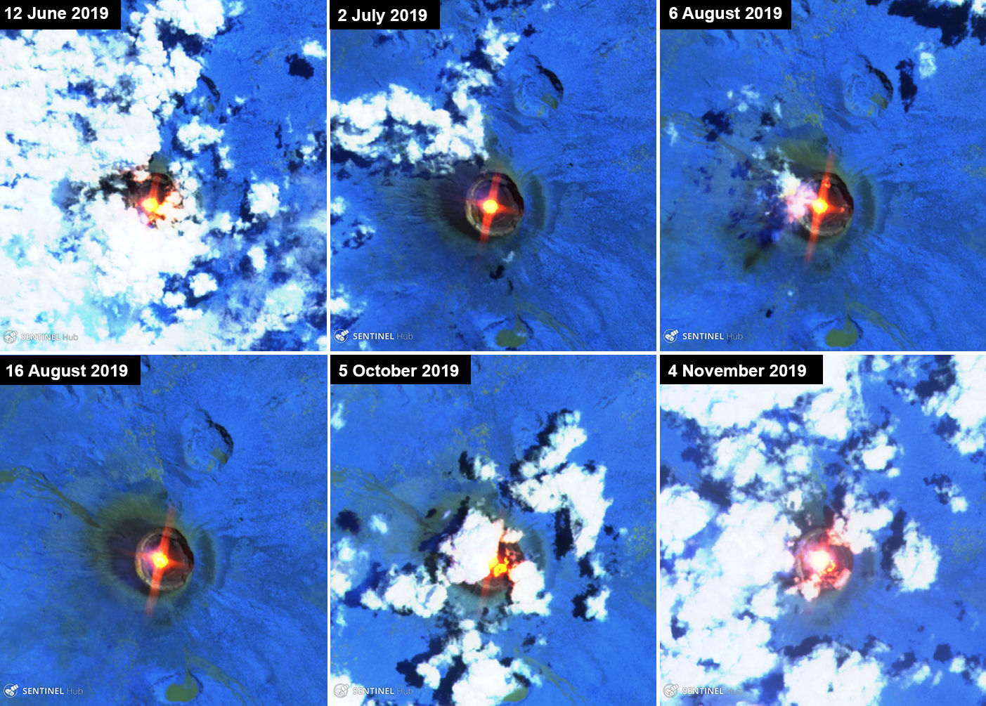 |
Figure 70. Sentinel-2 thermal satellite imagery (bands 12, 11, 8A) showed ongoing thermal activity (bright yellow-orange) at Nyiragongo during June through November 2019. Courtesy of Sentinel Hub Playground. |
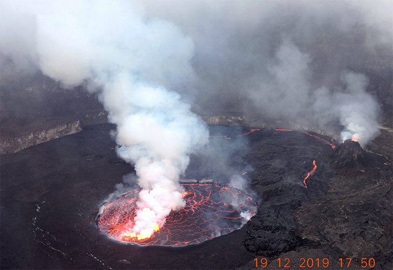 |
Figure 71. Photo of the active lava lake in the summit crater at Nyiragongo on 19 December 2019. Incandescence is accompanied by a gas-and-steam plume. Courtesy of OVG via Charles Balagizi. |
Geological Summary. The Nyiragongo stratovolcano contained a lava lake in its deep summit crater that was active for half a century before draining catastrophically through its outer flanks in 1977. The steep slopes contrast to the low profile of its neighboring shield volcano, Nyamuragira. Benches in the steep-walled, 1.2-km-wide summit crater mark levels of former lava lakes, which have been observed since the late-19th century. Two older stratovolcanoes, Baruta and Shaheru, are partially overlapped by Nyiragongo on the north and south. About 100 cones are located primarily along radial fissures south of Shaheru, east of the summit, and along a NE-SW zone extending as far as Lake Kivu. Many cones are buried by voluminous lava flows that extend long distances down the flanks, which is characterized by the eruption of foiditic rocks. The extremely fluid 1977 lava flows caused many fatalities, as did lava flows that inundated portions of the major city of Goma in January 2002.
Information Contacts: Observatoire Volcanologique de Goma (OVG), Departement de Geophysique, Centre de Recherche en Sciences Naturelles, Lwiro, D.S. Bukavu, DR Congo; MIROVA (Middle InfraRed Observation of Volcanic Activity), a collaborative project between the Universities of Turin and Florence (Italy) supported by the Centre for Volcanic Risk of the Italian Civil Protection Department (URL: http://www.mirovaweb.it/); Hawai'i Institute of Geophysics and Planetology (HIGP) - MODVOLC Thermal Alerts System, School of Ocean and Earth Science and Technology (SOEST), Univ. of Hawai'i, 2525 Correa Road, Honolulu, HI 96822, USA (URL: http://modis.higp.hawaii.edu/); Sentinel Hub Playground (URL: https://www.sentinel-hub.com/explore/sentinel-playground); Charles Balagizi (Twitter: @CharlesBalagizi, https://twitter.com/CharlesBalagizi).