Report on Calbuco (Chile) — 22 April-28 April 2015
Smithsonian Institution / US Geological Survey
Weekly Volcanic Activity Report, 22 April-28 April 2015
Managing Editor: Sally Sennert.
Please cite this report as:
Global Volcanism Program, 2015. Report on Calbuco (Chile) (Sennert, S, ed.). Weekly Volcanic Activity Report, 22 April-28 April 2015. Smithsonian Institution and US Geological Survey.
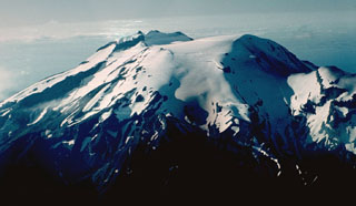
Calbuco
Chile
41.33°S, 72.618°W; summit elev. 1974 m
All times are local (unless otherwise noted)
OVDAS-SERNAGEOMIN reported that an eruption from Calbuco began at 1804 on 22 April, prompting the Alert Level to be raised to Red (the highest level on a four-color scale) and causing a 20-km exclusion zone to be declared. The eruption was preceded by an hour-long period of volcano-tectonic events followed by long-period events; no increases in seismicity had been noted since 2009 when real-time seismic monitoring started. After a large seismic event detected at 1735, a 90 minute eruption generated a sub-Plinian, gray ash plume that rose 15 km above the main crater and drifted mainly ENE, although fine ash drifted N and NW. Column collapses occurred locally and radially, affecting the headwaters of major rivers. Residents within the exclusion zone, in Chamiza, Lago Chapo, and Correntoso sectors, and in the town of Puerto Montt, were ordered to evacuate. Several roads and bridges were impassable due to ashfall.
A larger second event on 23 April began at 0100, lasted six hours, and also generated a sub-Plinian ash plume that rose higher than 15 km and drifted N, NE, and E. Incandescent tephra was ejected as far as 5 km; deposits were concentrated to the N and NE, with thicknesses varying from tens of centimeters in the Región de Los Lagos to a few millimeters in the Los Ríos and La Araucanía areas. Pyroclastic flows traveled a maximum distance of 7 km and lahars traveled 15 km. Pumice fell in Región de Los Lagos, and ash fell in Los Ríos and La Araucanía. Tephra also fell in Argentine territory, NE of the volcano. Scientists aboard an overflight observed ash emissions from at least six vents on the W, SW, and S sides of the old lava dome. About 5,000 people had been evacuated and ONEMI warned people not to go within 200 m of drainages due to lahar hazards. At around 2330 a third phase of surficial activity was noted; ash plumes rose 2 km and drifted NE and E. On 24 April the ash plume continued to rise 2 km and explosions were detected. News articles noted that international flights in and out of several major cities were delayed or canceled. According to a news article, ash from the eruption reached southern Brazil on 25 April prompting some airlines to cancel flights using airports in Santiago, Buenos Aires, and Montevideo. Some houses in areas near the volcano collapsed from the weight of the ash. The ash plume persisted on 25 April, but rose to a lower height of 400 m, and sporadic explosions were detected. Seismicity declined during 26-27 April; the ash plume rose 1.5 km, and drifted NE and SE. ONEMI noted on 27 April that 246 of 4,514 evacuees were in shelters; the number of displaced people had peaked at 6,514 during 24-26 April.
A satellite-based estimate of sulfur dioxide emissions was 0.3-0.4Tg by 28 April, detected as high as 21 km altitude. Although most ash had fallen out of the plume over Chile and Argentina, some may have remained in the stratospheric plume drifting around the globe; the leading edge of the gas plume had reached the Indian Ocean, S of Madagascar.
Geological Summary. Calbuco is one of the most active volcanoes of the southern Chilean Andes, along with its neighbor, Osorno. The late-Pleistocene to Holocene andesitic volcano is immediately SE of Lake Llanquihué in the Chilean lake district. Guanahuca, Guenauca, Huanauca, and Huanaque, all listed as synonyms of Calbuco (Catalog of Active Volcanoes of the World), are actually synonyms of nearby Osorno volcano (Moreno 1985, pers. comm.). The edifice is elongated in a SW-NE direction and is capped by a 400-500 m wide summit crater. The complex evolution included collapse of an intermediate edifice during the late Pleistocene that produced a 3-km3 debris avalanche that reached the lake. It has erupted frequently during the Holocene, and one of the largest historical eruptions in southern Chile took place from Calbuco in 1893-1894 that concluded with lava dome emplacement. Subsequent eruptions have enlarged the lava-dome complex in the summit crater.
Sources: Servicio Nacional de Geología y Minería (SERNAGEOMIN), Oficina Nacional de Emergencia-Ministerio del Interior (ONEMI), Simon Carn