
According to the civil protection agency, ONEMI, on 18 August OVDAS-SERNAGEOMIN reported that seismicity at Calbuco fluctuated at low levels and continued to decline, and only water vapor emissions rose from the vents. The Alert Level was lowered to Green (the lowest level on a four-color scale). ONEMI maintained an elevated Alert Level of Yellow (mid-level on a 3-color scale) for the Llanquihue and Puerto Octay provinces, and an Alert Level Green for Puerto Montt and Puerto Varas. On 21 August the 10-km exclusion zone around the volcano was lifted, but SERNAGEOMIN warned that the 1.5 km exclusion zone around the craters remained in effect and the public should continue to stay away from drainages.
Source: Oficina Nacional de Emergencia-Ministerio del Interior (ONEMI)
Eruption during 22-27 April 2015 with plumes above 15 km altitude; evacuations
Since an eruption in 1972, Calbuco's activity had been limited to a weak fumarole emission in May 1995 and a strong fumarole emission in August 1996 (BGVN 21:09). No further activity was reported until increased seismic activity and an eruption in April 2015. The volcano is monitored by the Observatorio Volcanológico de los Andes del Sur - El Servicio Nacional de Geología y Minería (OVDAS-SERNAGEOMIN).
According to OVDAS-SERNAGEOMIN, Calbuco erupted explosively at 1804 on 22 April 2015, sending an ash plume to more than 15 km above the crater, where it drifted primarily ENE (figure 1). The eruption had been immediately preceded by only 2-3 hours of increased seismicity (one hour of volcano-tectonic events followed by long-period events). During the 90-minute eruption, column collapses occurred locally and radially, affecting the headwaters of major rivers.
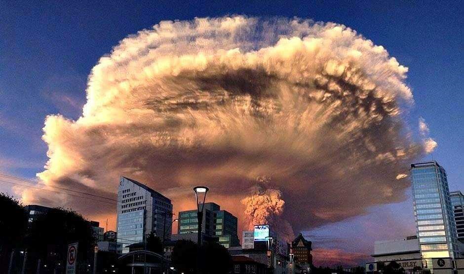 |
Figure 1. Photograph of the Calbuco explosion on 22 April 2015, taken from Puerto Montt, about 30 km SW of the volcano. Photo by Keraunos ob, posted on the Earth of Fire blog by Bernard Duyck. |
On 23 April at 0100 stronger activity began which lasted six hours and generated another ash plume that rose higher than 15 km and drifted NNE and E. Incandescent tephra was ejected as far as 5 km; deposits were concentrated to the N and NE, with thicknesses varying from tens of centimeters in the Región de Los Lagos to a few millimeters in the Los Ríos and La Araucanía regions. Pyroclastic flows traveled a maximum distance of 7 km and lahars traveled 15 km. Pumice fell in Región de Los Lagos, and ash fell in Los Ríos and La Araucanía. Tephra also fell in Argentine territory, NE of the volcano. Several roads and bridges were impassable due to ashfall. Scientists aboard an overflight observed ash emissions from at least six vents on the W, SW, and S sides of the old lava dome.
The eruption prompted OVDAS-SERNAGEOMIN to raise the Volcanic Alert Level from Green to Red (highest on a four-color scale). The Oficina Nacional de Emergencia del Ministerio del Interior (National Office of Emergency of the Interior Ministry, ONEMI) called for the evacuation of all people within 20 km of the volcano. About 5,000 residents were evacuated. ONEMI also warned people not to go within 200 m of drainages due to lahar hazards.
On 23 April at around 2330, a third period of activity resulted in ash plumes rising 2 km and drifting NE and E. On 24 April the ash plume continued to rise 2 km and explosions were detected. News articles noted that international travel was disrupted; flights in and out of several major cities were delayed or canceled. Thermal anomalies, based on MODIS satellite data, were also observed during 23-24 April.
According to one news report, ash from the eruption reached southern Brazil on 25 April, prompting some airlines to cancel flights in and out of Santiago, Buenos Aires, and Montevideo. Some houses in areas near the volcano had collapsed from the weight of the ash. Sporadic explosions caused continued ash plumes 25 April, but to a lower height of 400 m. Seismicity declined during 26-27 April; ash rose 1.5 km, and drifted NE and SE.
By 28 April, a satellite-based estimate of sulfur dioxide emissions was 0.3-0.4 Tg (Tg is one million metric tons), detected as high as 21 km altitude. Although most ash had fallen out of the plume over Chile and Argentina, some may have remained in the stratospheric plume drifting around the globe; the leading edge of the gas plume was detected over the Indian Ocean, S of Madagascar.
Seismic activity gradually declined, especially after 15 May 2015. OVDAS-SERNAGEOMIN reduced the Alert Level to Orange on 19 May and Yellow on 28 May. During the first part of August 2015, the Alert Level was decreased to Green, the lowest level. However, ONEMI maintained the Alert Level of Yellow for the province of Llanquihue and city of Puerto Octay (45 km NW of Calbuco), and an Alert Level Green for the cities of Puerto Montt (31 km SW of Calbuco) and Puerto Varas (31 km W of Calbuco).
According to ONEMI, on 18 August 2015 OVDAS-SERNAGEOMIN reported that seismicity fluctuated at low levels and continued to decline, with only water vapor rising from the vents. On 21 August the 10-km exclusion zone around the volcano was lifted, but SERNAGEOMIN warned that the 1.5 km exclusion zone around the craters remained in effect and the public should continue to stay away from drainages.
Information Contacts: Oficina Nacional de Emergencia del Ministerio del Interior (National Office of Emergency of the Interior Ministry, ONEMI) (URL: http://www.onemi.cl/); Observatorio Volcanológico de Los Andes del Sur (OVDAS) del Servicio Nacional de Geología y Minería (SERNAGEOMIN) (URL: http://www.sernageomin.cl/); Hawai'i Institute of Geophysics and Planetology (HIGP) MODVOLC Thermal Alerts System, School of Ocean and Earth Science and Technology (SOEST), Univ. of Hawai'i, 2525 Correa Road, Honolulu, HI 96822, USA (URL: http://modis.higp.hawaii.edu/); Wall Street Journal (URL: http://www.wsj.com/); Reuters (URL: http://www.reuters.com/); Simon Carn, Geological and Mining Engineering and Sciences, Michigan Technological University, 630 Dow Environmental Sciences, 1400 Townsend Drive, Houghton, MI 49931 USA (URL: https://so2.gsfc.nasa.gov/); Earth of Fire Blog (Bernard Duyck), 23 April 2015 (URL: http://www.earth-of-fire.com/archive/2015-04/).
According to the civil protection agency, ONEMI, on 18 August OVDAS-SERNAGEOMIN reported that seismicity at Calbuco fluctuated at low levels and continued to decline, and only water vapor emissions rose from the vents. The Alert Level was lowered to Green (the lowest level on a four-color scale). ONEMI maintained an elevated Alert Level of Yellow (mid-level on a 3-color scale) for the Llanquihue and Puerto Octay provinces, and an Alert Level Green for Puerto Montt and Puerto Varas. On 21 August the 10-km exclusion zone around the volcano was lifted, but SERNAGEOMIN warned that the 1.5 km exclusion zone around the craters remained in effect and the public should continue to stay away from drainages.
Source: Oficina Nacional de Emergencia-Ministerio del Interior (ONEMI)
On 27 May OVDAS-SERNAGEOMIN reported that seismicity at Calbuco fluctuated at low levels and continued to decline. According to ONEMI, the 10-km evacuation zone remained in effect, with controlled access to some communities allowed for part of the day; about 500 people remained displaced. On 28 May OVDAS-SERNAGEOMIN lowered the Alert Level to Yellow (the second lowest level on a four-color scale).
Source: Servicio Nacional de Geología y Minería (SERNAGEOMIN)
OVDAS-SERNAGEOMIN reported that during 20-26 May activity at Calbuco fluctuated at low levels and continued to decline. Inclement weather prevented observations of the summit area on most days; white plumes were observed rising 300-400 m and drifting SE during 24-26 May, and incandescence at the crater was observed at night during 25-26 May. According to ONEMI, the number of evacuees within the 20-km evacuation zone remained at 6,685 on 26 May. The Alert Level remained at Orange (the second highest level on a four-color scale), and the 10-km-radius exclusion zone continued to be in effect.
Sources: Servicio Nacional de Geología y Minería (SERNAGEOMIN); Oficina Nacional de Emergencia-Ministerio del Interior (ONEMI)
OVDAS-SERNAGEOMIN reported that during 13-19 May activity at Calbuco fluctuated at low levels and continued to decline. Inclement weather prevented daily observations of the summit area, although incandescence at the crater was observed during 17-18 May. According to ONEMI, the number of evacuees within the 20-km evacuation zone remained at 6,685 on 18 May. On 19 May the Alert Level was lowered to Orange (the second highest level on a four-color scale), and the exclusion zone was changed to a 10-km radius.
Sources: Servicio Nacional de Geología y Minería (SERNAGEOMIN); Oficina Nacional de Emergencia-Ministerio del Interior (ONEMI)
OVDAS-SERNAGEOMIN reported that on 6 May activity at Calbuco fluctuated; a sudden increase of tremor that began at 1304 and lasted two hours was accompanied by increased gas-and-ash emissions. During 7-11 May the gas-and-ash emissions were steady and low (less than 1 km), and drifted E, SE, and S; inclement weather prevented observations during 8-10 and 12 May. Moderate levels of tremor were detected through 9 May, and then decreased to low levels through 12 May. According to ONEMI, the number of evacuees within the 20-km evacuation zone remained at 6,685 on 12 May. In addition 3,221 animals, including sheep, goats, cows, and horses, had been evacuated. The Alert Level remained at Red (the highest level on a four-color scale).
Satellite images showed that the aerosol plume from the initial few days of the eruption had traveled around the world once; faint layers of the plume were 14-16 km above parts of South America during 8-9 May.
Sources: Servicio Nacional de Geología y Minería (SERNAGEOMIN); Oficina Nacional de Emergencia-Ministerio del Interior (ONEMI); Mike Fromm, US Naval Research Laboratory
OVDAS-SERNAGEOMIN reported that on 29 April a weak ash plume rose as high as 1.5 km above Calbuco and seismicity remained stable. An event that began at 1308 on 30 April produced an ash plume that rose 3-5 km and drifted SE. A small lahar in the Blanco River may have been caused by a pyroclastic flow. Tremor amplitude increased and became sustained after the event. On 2 May the number of earthquakes increased. Seismicity significantly increased on 3 May, characterized by a swarm of volcano-tectonic events, and then decreased afterwards. Seismicity was low and stable on 5 May. A plume rose less than 1 km during 1-3 May; cloud cover prevented visual observations of the volcano during 4-5 May. According to ONEMI, the number of evacuees totaled 6,685 on 5 May. The Alert Level remained at Red (the highest level on a four-color scale).
Sources: Servicio Nacional de Geología y Minería (SERNAGEOMIN); Oficina Nacional de Emergencia-Ministerio del Interior (ONEMI)
OVDAS-SERNAGEOMIN reported that an eruption from Calbuco began at 1804 on 22 April, prompting the Alert Level to be raised to Red (the highest level on a four-color scale) and causing a 20-km exclusion zone to be declared. The eruption was preceded by an hour-long period of volcano-tectonic events followed by long-period events; no increases in seismicity had been noted since 2009 when real-time seismic monitoring started. After a large seismic event detected at 1735, a 90 minute eruption generated a sub-Plinian, gray ash plume that rose 15 km above the main crater and drifted mainly ENE, although fine ash drifted N and NW. Column collapses occurred locally and radially, affecting the headwaters of major rivers. Residents within the exclusion zone, in Chamiza, Lago Chapo, and Correntoso sectors, and in the town of Puerto Montt, were ordered to evacuate. Several roads and bridges were impassable due to ashfall.
A larger second event on 23 April began at 0100, lasted six hours, and also generated a sub-Plinian ash plume that rose higher than 15 km and drifted N, NE, and E. Incandescent tephra was ejected as far as 5 km; deposits were concentrated to the N and NE, with thicknesses varying from tens of centimeters in the Región de Los Lagos to a few millimeters in the Los Ríos and La Araucanía areas. Pyroclastic flows traveled a maximum distance of 7 km and lahars traveled 15 km. Pumice fell in Región de Los Lagos, and ash fell in Los Ríos and La Araucanía. Tephra also fell in Argentine territory, NE of the volcano. Scientists aboard an overflight observed ash emissions from at least six vents on the W, SW, and S sides of the old lava dome. About 5,000 people had been evacuated and ONEMI warned people not to go within 200 m of drainages due to lahar hazards. At around 2330 a third phase of surficial activity was noted; ash plumes rose 2 km and drifted NE and E. On 24 April the ash plume continued to rise 2 km and explosions were detected. News articles noted that international flights in and out of several major cities were delayed or canceled. According to a news article, ash from the eruption reached southern Brazil on 25 April prompting some airlines to cancel flights using airports in Santiago, Buenos Aires, and Montevideo. Some houses in areas near the volcano collapsed from the weight of the ash. The ash plume persisted on 25 April, but rose to a lower height of 400 m, and sporadic explosions were detected. Seismicity declined during 26-27 April; the ash plume rose 1.5 km, and drifted NE and SE. ONEMI noted on 27 April that 246 of 4,514 evacuees were in shelters; the number of displaced people had peaked at 6,514 during 24-26 April.
A satellite-based estimate of sulfur dioxide emissions was 0.3-0.4Tg by 28 April, detected as high as 21 km altitude. Although most ash had fallen out of the plume over Chile and Argentina, some may have remained in the stratospheric plume drifting around the globe; the leading edge of the gas plume had reached the Indian Ocean, S of Madagascar.
Sources: Servicio Nacional de Geología y Minería (SERNAGEOMIN); Oficina Nacional de Emergencia-Ministerio del Interior (ONEMI); Simon Carn
Reports are organized chronologically and indexed below by Month/Year (Publication Volume:Number), and include a one-line summary. Click on the index link or scroll down to read the reports.
Strong fumarolic emission from main crater
On the morning of 12 August, the ~250,000 residents of Puerto Montt (35 km SW) and Puerto Varas (36 km SW) were alarmed by strong fumarolic emissions from the 1.5-km-diameter main crater of Calbuco. In May 1995 a weak fumarole was noticed and filmed from a helicopter. Prior to that, Calbuco had showed no signs of activity since a 1972 eruption that lasted for ~4 hours.
Calbuco is a very explosive late Pleistocene to Holocene andesitic volcano S of Lake Llanquihue that underwent edifice collapse in the late Pleistocene, producing a volcanic debris avalanche that reached the lake. One of the largest historical eruptions in southern Chile took place from Calbuco in 1893-1894. Violent eruptions ejected 30-cm bombs to distances of 8 km from the crater, accompanied by voluminous hot lahars. Several days of darkness occurred in San Carlos de Bariloche, Argentina (>100 km SE). Strong explosions occurred in April 1917, and a lava dome formed in the crater accompanied by hot lahars. Another short explosive eruption in January 1929 also included an apparent pyroclastic flow and a lava flow. The last major eruption of Calbuco, in 1961, sent ash columns 12-15 km high and produced plumes that dispersed mainly to the SE as far as Bariloche; two lava flows were also emitted.
Information Contacts: Hugo Moreno, Observatorio Volcanologico de los Andes del Sur (OVDAS), Universidad de la Frontera, Casilla 54-D, Temuco, Chile.
Eruption during 22-27 April 2015 with plumes above 15 km altitude; evacuations
Since an eruption in 1972, Calbuco's activity had been limited to a weak fumarole emission in May 1995 and a strong fumarole emission in August 1996 (BGVN 21:09). No further activity was reported until increased seismic activity and an eruption in April 2015. The volcano is monitored by the Observatorio Volcanológico de los Andes del Sur - El Servicio Nacional de Geología y Minería (OVDAS-SERNAGEOMIN).
According to OVDAS-SERNAGEOMIN, Calbuco erupted explosively at 1804 on 22 April 2015, sending an ash plume to more than 15 km above the crater, where it drifted primarily ENE (figure 1). The eruption had been immediately preceded by only 2-3 hours of increased seismicity (one hour of volcano-tectonic events followed by long-period events). During the 90-minute eruption, column collapses occurred locally and radially, affecting the headwaters of major rivers.
|
Figure 1. Photograph of the Calbuco explosion on 22 April 2015, taken from Puerto Montt, about 30 km SW of the volcano. Photo by Keraunos ob, posted on the Earth of Fire blog by Bernard Duyck. |
On 23 April at 0100 stronger activity began which lasted six hours and generated another ash plume that rose higher than 15 km and drifted NNE and E. Incandescent tephra was ejected as far as 5 km; deposits were concentrated to the N and NE, with thicknesses varying from tens of centimeters in the Región de Los Lagos to a few millimeters in the Los Ríos and La Araucanía regions. Pyroclastic flows traveled a maximum distance of 7 km and lahars traveled 15 km. Pumice fell in Región de Los Lagos, and ash fell in Los Ríos and La Araucanía. Tephra also fell in Argentine territory, NE of the volcano. Several roads and bridges were impassable due to ashfall. Scientists aboard an overflight observed ash emissions from at least six vents on the W, SW, and S sides of the old lava dome.
The eruption prompted OVDAS-SERNAGEOMIN to raise the Volcanic Alert Level from Green to Red (highest on a four-color scale). The Oficina Nacional de Emergencia del Ministerio del Interior (National Office of Emergency of the Interior Ministry, ONEMI) called for the evacuation of all people within 20 km of the volcano. About 5,000 residents were evacuated. ONEMI also warned people not to go within 200 m of drainages due to lahar hazards.
On 23 April at around 2330, a third period of activity resulted in ash plumes rising 2 km and drifting NE and E. On 24 April the ash plume continued to rise 2 km and explosions were detected. News articles noted that international travel was disrupted; flights in and out of several major cities were delayed or canceled. Thermal anomalies, based on MODIS satellite data, were also observed during 23-24 April.
According to one news report, ash from the eruption reached southern Brazil on 25 April, prompting some airlines to cancel flights in and out of Santiago, Buenos Aires, and Montevideo. Some houses in areas near the volcano had collapsed from the weight of the ash. Sporadic explosions caused continued ash plumes 25 April, but to a lower height of 400 m. Seismicity declined during 26-27 April; ash rose 1.5 km, and drifted NE and SE.
By 28 April, a satellite-based estimate of sulfur dioxide emissions was 0.3-0.4 Tg (Tg is one million metric tons), detected as high as 21 km altitude. Although most ash had fallen out of the plume over Chile and Argentina, some may have remained in the stratospheric plume drifting around the globe; the leading edge of the gas plume was detected over the Indian Ocean, S of Madagascar.
Seismic activity gradually declined, especially after 15 May 2015. OVDAS-SERNAGEOMIN reduced the Alert Level to Orange on 19 May and Yellow on 28 May. During the first part of August 2015, the Alert Level was decreased to Green, the lowest level. However, ONEMI maintained the Alert Level of Yellow for the province of Llanquihue and city of Puerto Octay (45 km NW of Calbuco), and an Alert Level Green for the cities of Puerto Montt (31 km SW of Calbuco) and Puerto Varas (31 km W of Calbuco).
According to ONEMI, on 18 August 2015 OVDAS-SERNAGEOMIN reported that seismicity fluctuated at low levels and continued to decline, with only water vapor rising from the vents. On 21 August the 10-km exclusion zone around the volcano was lifted, but SERNAGEOMIN warned that the 1.5 km exclusion zone around the craters remained in effect and the public should continue to stay away from drainages.
Information Contacts: Oficina Nacional de Emergencia del Ministerio del Interior (National Office of Emergency of the Interior Ministry, ONEMI) (URL: http://www.onemi.cl/); Observatorio Volcanológico de Los Andes del Sur (OVDAS) del Servicio Nacional de Geología y Minería (SERNAGEOMIN) (URL: http://www.sernageomin.cl/); Hawai'i Institute of Geophysics and Planetology (HIGP) MODVOLC Thermal Alerts System, School of Ocean and Earth Science and Technology (SOEST), Univ. of Hawai'i, 2525 Correa Road, Honolulu, HI 96822, USA (URL: http://modis.higp.hawaii.edu/); Wall Street Journal (URL: http://www.wsj.com/); Reuters (URL: http://www.reuters.com/); Simon Carn, Geological and Mining Engineering and Sciences, Michigan Technological University, 630 Dow Environmental Sciences, 1400 Townsend Drive, Houghton, MI 49931 USA (URL: https://so2.gsfc.nasa.gov/); Earth of Fire Blog (Bernard Duyck), 23 April 2015 (URL: http://www.earth-of-fire.com/archive/2015-04/).
|
|
||||||||||||||||||||||||||
There is data available for 36 confirmed eruptive periods.
2015 Apr 22 - 2015 May 26 Confirmed Eruption (Explosive / Effusive) VEI: 4
| Episode 1 | Eruption (Explosive / Effusive) | Summit crater | ||||||||||||||||||||||||||||||||||||||||||||||||||||||||||||||||||||||||||||||||||||||||||||||||||||||||||||||||||||||||||||||||||||||||||||||||||||||||||||||||||||||||||||||||||||||||||||
|---|---|---|---|---|---|---|---|---|---|---|---|---|---|---|---|---|---|---|---|---|---|---|---|---|---|---|---|---|---|---|---|---|---|---|---|---|---|---|---|---|---|---|---|---|---|---|---|---|---|---|---|---|---|---|---|---|---|---|---|---|---|---|---|---|---|---|---|---|---|---|---|---|---|---|---|---|---|---|---|---|---|---|---|---|---|---|---|---|---|---|---|---|---|---|---|---|---|---|---|---|---|---|---|---|---|---|---|---|---|---|---|---|---|---|---|---|---|---|---|---|---|---|---|---|---|---|---|---|---|---|---|---|---|---|---|---|---|---|---|---|---|---|---|---|---|---|---|---|---|---|---|---|---|---|---|---|---|---|---|---|---|---|---|---|---|---|---|---|---|---|---|---|---|---|---|---|---|---|---|---|---|---|---|---|---|---|---|---|---|
| 2015 Apr 22 - 2015 May 26 | Evidence from Observations: Reported | ||||||||||||||||||||||||||||||||||||||||||||||||||||||||||||||||||||||||||||||||||||||||||||||||||||||||||||||||||||||||||||||||||||||||||||||||||||||||||||||||||||||||||||||||||||||||||||
|
List of 36 Events for Episode 1 at Summit crater
|
|||||||||||||||||||||||||||||||||||||||||||||||||||||||||||||||||||||||||||||||||||||||||||||||||||||||||||||||||||||||||||||||||||||||||||||||||||||||||||||||||||||||||||||||||||||||||||||
1972 Aug 26 - 1972 Aug 26 Confirmed Eruption (Explosive / Effusive) VEI: 2
| Episode 1 | Eruption (Explosive / Effusive) | |||||||||||||||||||||||||||||||||||||||
|---|---|---|---|---|---|---|---|---|---|---|---|---|---|---|---|---|---|---|---|---|---|---|---|---|---|---|---|---|---|---|---|---|---|---|---|---|---|---|---|
| 1972 Aug 26 - 1972 Aug 26 | Evidence from Observations: Reported | ||||||||||||||||||||||||||||||||||||||
|
List of 6 Events for Episode 1
|
|||||||||||||||||||||||||||||||||||||||
1961 Feb 1 - 1961 Mar 26 (on or after) Confirmed Eruption (Explosive / Effusive) VEI: 3
| Episode 1 | Eruption (Explosive / Effusive) | ||||||||||||||||||||||||||||||||||||||||||||
|---|---|---|---|---|---|---|---|---|---|---|---|---|---|---|---|---|---|---|---|---|---|---|---|---|---|---|---|---|---|---|---|---|---|---|---|---|---|---|---|---|---|---|---|---|
| 1961 Feb 1 - 1961 Mar 26 (on or after) | Evidence from Observations: Reported | |||||||||||||||||||||||||||||||||||||||||||
|
List of 7 Events for Episode 1
|
||||||||||||||||||||||||||||||||||||||||||||
1945 Confirmed Eruption (Explosive / Effusive)
| Episode 1 | Eruption (Explosive / Effusive) | ||||
|---|---|---|---|---|
| 1945 - Unknown | Evidence from Observations: Reported | |||
1932 Confirmed Eruption (Explosive / Effusive)
| Episode 1 | Eruption (Explosive / Effusive) | ||||
|---|---|---|---|---|
| 1932 - Unknown | Evidence from Observations: Reported | |||
1929 Jan 6 - 1929 Jan 6 Confirmed Eruption (Explosive / Effusive) VEI: 3 (?)
| Episode 1 | Eruption (Explosive / Effusive) | ||||||||||||||||||||||||||||||||||||||||||||||||||||||
|---|---|---|---|---|---|---|---|---|---|---|---|---|---|---|---|---|---|---|---|---|---|---|---|---|---|---|---|---|---|---|---|---|---|---|---|---|---|---|---|---|---|---|---|---|---|---|---|---|---|---|---|---|---|---|
| 1929 Jan 6 - 1929 Jan 6 | Evidence from Observations: Reported | |||||||||||||||||||||||||||||||||||||||||||||||||||||
|
List of 9 Events for Episode 1
|
||||||||||||||||||||||||||||||||||||||||||||||||||||||
1917 Apr - 1917 May Confirmed Eruption (Explosive / Effusive) VEI: 3 (?)
| Episode 1 | Eruption (Explosive / Effusive) | ||||||||||||||||||||||||||||||||||||||||||||
|---|---|---|---|---|---|---|---|---|---|---|---|---|---|---|---|---|---|---|---|---|---|---|---|---|---|---|---|---|---|---|---|---|---|---|---|---|---|---|---|---|---|---|---|---|
| 1917 Apr - 1917 May | Evidence from Observations: Reported | |||||||||||||||||||||||||||||||||||||||||||
|
List of 7 Events for Episode 1
|
||||||||||||||||||||||||||||||||||||||||||||
1911 - 1912 Confirmed Eruption (Explosive / Effusive) VEI: 2
| Episode 1 | Eruption (Explosive / Effusive) | ||||||||||||||||||||||||
|---|---|---|---|---|---|---|---|---|---|---|---|---|---|---|---|---|---|---|---|---|---|---|---|---|
| 1911 - 1912 | Evidence from Observations: Reported | |||||||||||||||||||||||
|
List of 3 Events for Episode 1
|
||||||||||||||||||||||||
1909 Mar Confirmed Eruption (Explosive / Effusive) VEI: 2
| Episode 1 | Eruption (Explosive / Effusive) | ||||||||||||||||||||||||
|---|---|---|---|---|---|---|---|---|---|---|---|---|---|---|---|---|---|---|---|---|---|---|---|---|
| 1909 Mar - Unknown | Evidence from Observations: Reported | |||||||||||||||||||||||
|
List of 3 Events for Episode 1
|
||||||||||||||||||||||||
1907 Apr 22 Confirmed Eruption (Explosive / Effusive) VEI: 2 (?)
| Episode 1 | Eruption (Explosive / Effusive) | ||||||||||||||||||||||||
|---|---|---|---|---|---|---|---|---|---|---|---|---|---|---|---|---|---|---|---|---|---|---|---|---|
| 1907 Apr 22 - Unknown | Evidence from Observations: Reported | |||||||||||||||||||||||
|
List of 3 Events for Episode 1
|
||||||||||||||||||||||||
1906 Confirmed Eruption (Explosive / Effusive) VEI: 2
| Episode 1 | Eruption (Explosive / Effusive) | ||||||||||||||||||||||||
|---|---|---|---|---|---|---|---|---|---|---|---|---|---|---|---|---|---|---|---|---|---|---|---|---|
| 1906 - Unknown | Evidence from Observations: Reported | |||||||||||||||||||||||
|
List of 3 Events for Episode 1
|
||||||||||||||||||||||||
1894 Nov 16 - 1895 (?) Confirmed Eruption (Explosive / Effusive) VEI: 2 (?)
| Episode 1 | Eruption (Explosive / Effusive) | |||||||||||||||||||||||||||||
|---|---|---|---|---|---|---|---|---|---|---|---|---|---|---|---|---|---|---|---|---|---|---|---|---|---|---|---|---|---|
| 1894 Nov 16 - 1895 (?) | Evidence from Observations: Reported | ||||||||||||||||||||||||||||
|
List of 4 Events for Episode 1
|
|||||||||||||||||||||||||||||
1893 Jan 7 - 1894 Jan 16 (on or after) Confirmed Eruption (Explosive / Effusive) VEI: 4
| Episode 1 | Eruption (Explosive / Effusive) | ||||||||||||||||||||||||||||||||||||||||||||||||||||||
|---|---|---|---|---|---|---|---|---|---|---|---|---|---|---|---|---|---|---|---|---|---|---|---|---|---|---|---|---|---|---|---|---|---|---|---|---|---|---|---|---|---|---|---|---|---|---|---|---|---|---|---|---|---|---|
| 1893 Jan 7 - 1894 Jan 16 (on or after) | Evidence from Observations: Reported | |||||||||||||||||||||||||||||||||||||||||||||||||||||
|
List of 9 Events for Episode 1
|
||||||||||||||||||||||||||||||||||||||||||||||||||||||
[ 1837 - 1838 ] Discredited Eruption
1792 (?) Confirmed Eruption (Explosive / Effusive)
| Episode 1 | Eruption (Explosive / Effusive) | ||||||||||||||||||||||||||||||||||
|---|---|---|---|---|---|---|---|---|---|---|---|---|---|---|---|---|---|---|---|---|---|---|---|---|---|---|---|---|---|---|---|---|---|---|
| 1792 (?) - Unknown | Evidence from Observations: Reported | |||||||||||||||||||||||||||||||||
|
List of 5 Events for Episode 1
|
||||||||||||||||||||||||||||||||||
1600 ± 75 years Confirmed Eruption (Explosive / Effusive)
| Episode 1 | Eruption (Explosive / Effusive) | ||||||||||||||||||||||||
|---|---|---|---|---|---|---|---|---|---|---|---|---|---|---|---|---|---|---|---|---|---|---|---|---|
| 1600 ± 75 years - Unknown | Evidence from Isotopic: 14C (uncalibrated) | |||||||||||||||||||||||
|
List of 3 Events for Episode 1
|
||||||||||||||||||||||||
1380 ± 50 years Confirmed Eruption (Explosive / Effusive)
| Episode 1 | Eruption (Explosive / Effusive) | |||||||||||||||||||||||||||||
|---|---|---|---|---|---|---|---|---|---|---|---|---|---|---|---|---|---|---|---|---|---|---|---|---|---|---|---|---|---|
| 1380 ± 50 years - Unknown | Evidence from Isotopic: 14C (uncalibrated) | ||||||||||||||||||||||||||||
|
List of 4 Events for Episode 1
|
|||||||||||||||||||||||||||||
0710 ± 60 years Confirmed Eruption (Explosive / Effusive) VEI: 4
| Episode 1 | Eruption (Explosive / Effusive) | Ca13 tephra | ||||||||||||||||||||||||||||
|---|---|---|---|---|---|---|---|---|---|---|---|---|---|---|---|---|---|---|---|---|---|---|---|---|---|---|---|---|---|
| 0710 ± 60 years - Unknown | Evidence from Isotopic: 14C (calibrated) | ||||||||||||||||||||||||||||
|
List of 4 Events for Episode 1 at Ca13 tephra
|
|||||||||||||||||||||||||||||
0520 ± 200 years Confirmed Eruption (Explosive / Effusive)
| Episode 1 | Eruption (Explosive / Effusive) | ||||||||||||||||||||||||
|---|---|---|---|---|---|---|---|---|---|---|---|---|---|---|---|---|---|---|---|---|---|---|---|---|
| 0520 ± 200 years - Unknown | Evidence from Isotopic: 14C (uncalibrated) | |||||||||||||||||||||||
|
List of 3 Events for Episode 1
|
||||||||||||||||||||||||
0220 ± 75 years Confirmed Eruption (Explosive / Effusive)
| Episode 1 | Eruption (Explosive / Effusive) | |||||||||||||||||||||||||||||
|---|---|---|---|---|---|---|---|---|---|---|---|---|---|---|---|---|---|---|---|---|---|---|---|---|---|---|---|---|---|
| 0220 ± 75 years - Unknown | Evidence from Isotopic: 14C (uncalibrated) | ||||||||||||||||||||||||||||
|
List of 4 Events for Episode 1
|
|||||||||||||||||||||||||||||
0160 ± 135 years Confirmed Eruption (Explosive / Effusive) VEI: 4
| Episode 1 | Eruption (Explosive / Effusive) | Ca12 tephra | ||||||||||||||||||||||||||||
|---|---|---|---|---|---|---|---|---|---|---|---|---|---|---|---|---|---|---|---|---|---|---|---|---|---|---|---|---|---|
| 0160 ± 135 years - Unknown | Evidence from Correlation: Tephrochronology | ||||||||||||||||||||||||||||
|
List of 4 Events for Episode 1 at Ca12 tephra
|
|||||||||||||||||||||||||||||
0040 ± 75 years Confirmed Eruption (Explosive / Effusive)
| Episode 1 | Eruption (Explosive / Effusive) | |||||||||||||||||||||||||||||
|---|---|---|---|---|---|---|---|---|---|---|---|---|---|---|---|---|---|---|---|---|---|---|---|---|---|---|---|---|---|
| 0040 ± 75 years - Unknown | Evidence from Isotopic: 14C (uncalibrated) | ||||||||||||||||||||||||||||
|
List of 4 Events for Episode 1
|
|||||||||||||||||||||||||||||
0100 BCE ± 100 years Confirmed Eruption (Explosive / Effusive)
| Episode 1 | Eruption (Explosive / Effusive) | ||||||||||||||||||||||||||||||||||
|---|---|---|---|---|---|---|---|---|---|---|---|---|---|---|---|---|---|---|---|---|---|---|---|---|---|---|---|---|---|---|---|---|---|---|
| 0100 BCE ± 100 years - Unknown | Evidence from Isotopic: 14C (uncalibrated) | |||||||||||||||||||||||||||||||||
|
List of 5 Events for Episode 1
|
||||||||||||||||||||||||||||||||||
0330 BCE ± 200 years Confirmed Eruption (Explosive / Effusive)
| Episode 1 | Eruption (Explosive / Effusive) | |||||||||||||||||||||||||||||
|---|---|---|---|---|---|---|---|---|---|---|---|---|---|---|---|---|---|---|---|---|---|---|---|---|---|---|---|---|---|
| 0330 BCE ± 200 years - Unknown | Evidence from Isotopic: 14C (uncalibrated) | ||||||||||||||||||||||||||||
|
List of 4 Events for Episode 1
|
|||||||||||||||||||||||||||||
1920 BCE ± 50 years Confirmed Eruption (Explosive / Effusive)
| Episode 1 | Eruption (Explosive / Effusive) | |||||||||||||||||||||||||||||
|---|---|---|---|---|---|---|---|---|---|---|---|---|---|---|---|---|---|---|---|---|---|---|---|---|---|---|---|---|---|
| 1920 BCE ± 50 years - Unknown | Evidence from Isotopic: 14C (uncalibrated) | ||||||||||||||||||||||||||||
|
List of 4 Events for Episode 1
|
|||||||||||||||||||||||||||||
4300 BCE ± 150 years Confirmed Eruption (Explosive / Effusive)
| Episode 1 | Eruption (Explosive / Effusive) | |||||||||||||||||||||||||||||
|---|---|---|---|---|---|---|---|---|---|---|---|---|---|---|---|---|---|---|---|---|---|---|---|---|---|---|---|---|---|
| 4300 BCE ± 150 years - Unknown | Evidence from Isotopic: 14C (uncalibrated) | ||||||||||||||||||||||||||||
|
List of 4 Events for Episode 1
|
|||||||||||||||||||||||||||||
5030 BCE ± 180 years Confirmed Eruption (Explosive / Effusive) VEI: 4
| Episode 1 | Eruption (Explosive / Effusive) | Ca11 tephra layer | ||||||||||||||||||||||||||||
|---|---|---|---|---|---|---|---|---|---|---|---|---|---|---|---|---|---|---|---|---|---|---|---|---|---|---|---|---|---|
| 5030 BCE ± 180 years - Unknown | Evidence from Isotopic: 14C (calibrated) | ||||||||||||||||||||||||||||
|
List of 4 Events for Episode 1 at Ca11 tephra layer
|
|||||||||||||||||||||||||||||
5820 BCE ± 880 years Confirmed Eruption (Explosive / Effusive) VEI: 4
| Episode 1 | Eruption (Explosive / Effusive) | Ca10 tephra layer | |||||||||||||||||||||||||||||||||
|---|---|---|---|---|---|---|---|---|---|---|---|---|---|---|---|---|---|---|---|---|---|---|---|---|---|---|---|---|---|---|---|---|---|---|
| 5820 BCE ± 880 years - Unknown | Evidence from Correlation: Tephrochronology | |||||||||||||||||||||||||||||||||
|
List of 5 Events for Episode 1 at Ca10 tephra layer
|
||||||||||||||||||||||||||||||||||
6300 BCE ± 1035 years Confirmed Eruption (Explosive / Effusive)
| Episode 1 | Eruption (Explosive / Effusive) | Ca9 tephra layer | |||||||||||||||||||||||
|---|---|---|---|---|---|---|---|---|---|---|---|---|---|---|---|---|---|---|---|---|---|---|---|---|
| 6300 BCE ± 1035 years - Unknown | Evidence from Correlation: Tephrochronology | |||||||||||||||||||||||
|
List of 3 Events for Episode 1 at Ca9 tephra layer
|
||||||||||||||||||||||||
6760 BCE ± 825 years Confirmed Eruption (Explosive / Effusive) VEI: 5
| Episode 1 | Eruption (Explosive / Effusive) | Ca8 tephra layer | |||||||||||||||||||||||||||||||||
|---|---|---|---|---|---|---|---|---|---|---|---|---|---|---|---|---|---|---|---|---|---|---|---|---|---|---|---|---|---|---|---|---|---|---|
| 6760 BCE ± 825 years - Unknown | Evidence from Correlation: Tephrochronology | |||||||||||||||||||||||||||||||||
|
List of 5 Events for Episode 1 at Ca8 tephra layer
|
||||||||||||||||||||||||||||||||||
7550 BCE ± 45 years Confirmed Eruption (Explosive / Effusive) VEI: 4
| Episode 1 | Eruption (Explosive / Effusive) | Ca7 tephra layer | ||||||||||||||||||||||||||||
|---|---|---|---|---|---|---|---|---|---|---|---|---|---|---|---|---|---|---|---|---|---|---|---|---|---|---|---|---|---|
| 7550 BCE ± 45 years - Unknown | Evidence from Isotopic: 14C (calibrated) | ||||||||||||||||||||||||||||
|
List of 4 Events for Episode 1 at Ca7 tephra layer
|
|||||||||||||||||||||||||||||
7930 BCE ± 275 years Confirmed Eruption (Explosive / Effusive)
| Episode 1 | Eruption (Explosive / Effusive) | Ca6 tephra layer | |||||||||||||||||||||||
|---|---|---|---|---|---|---|---|---|---|---|---|---|---|---|---|---|---|---|---|---|---|---|---|---|
| 7930 BCE ± 275 years - Unknown | Evidence from Correlation: Tephrochronology | |||||||||||||||||||||||
|
List of 3 Events for Episode 1 at Ca6 tephra layer
|
||||||||||||||||||||||||
7990 BCE ± 290 years Confirmed Eruption (Explosive / Effusive)
| Episode 1 | Eruption (Explosive / Effusive) | Ca5 tephra layer | |||||||||||||||||||||||
|---|---|---|---|---|---|---|---|---|---|---|---|---|---|---|---|---|---|---|---|---|---|---|---|---|
| 7990 BCE ± 290 years - Unknown | Evidence from Correlation: Tephrochronology | |||||||||||||||||||||||
|
List of 3 Events for Episode 1 at Ca5 tephra layer
|
||||||||||||||||||||||||
8100 BCE ± 1300 years Confirmed Eruption (Explosive / Effusive)
| Episode 1 | Eruption (Explosive / Effusive) | Ca4 tephra layer | |||||||||||||||||||||||
|---|---|---|---|---|---|---|---|---|---|---|---|---|---|---|---|---|---|---|---|---|---|---|---|---|
| 8100 BCE ± 1300 years - Unknown | Evidence from Correlation: Tephrochronology | |||||||||||||||||||||||
|
List of 3 Events for Episode 1 at Ca4 tephra layer
|
||||||||||||||||||||||||
8210 BCE ± 290 years Confirmed Eruption (Explosive / Effusive)
| Episode 1 | Eruption (Explosive / Effusive) | Ca3 tephra layer | |||||||||||||||||||||||
|---|---|---|---|---|---|---|---|---|---|---|---|---|---|---|---|---|---|---|---|---|---|---|---|---|
| 8210 BCE ± 290 years - Unknown | Evidence from Correlation: Tephrochronology | |||||||||||||||||||||||
|
List of 3 Events for Episode 1 at Ca3 tephra layer
|
||||||||||||||||||||||||
8320 BCE ± 250 years Confirmed Eruption (Explosive / Effusive)
| Episode 1 | Eruption (Explosive / Effusive) | Ca2 tephra layer | |||||||||||||||||||||||
|---|---|---|---|---|---|---|---|---|---|---|---|---|---|---|---|---|---|---|---|---|---|---|---|---|
| 8320 BCE ± 250 years - Unknown | Evidence from Correlation: Tephrochronology | |||||||||||||||||||||||
|
List of 3 Events for Episode 1 at Ca2 tephra layer
|
||||||||||||||||||||||||
8460 BCE ± 155 years Confirmed Eruption (Explosive / Effusive) VEI: 5
| Episode 1 | Eruption (Explosive / Effusive) | Ca1 tephra layer | ||||||||||||||||||||||||||||
|---|---|---|---|---|---|---|---|---|---|---|---|---|---|---|---|---|---|---|---|---|---|---|---|---|---|---|---|---|---|
| 8460 BCE ± 155 years - Unknown | Evidence from Isotopic: 14C (calibrated) | ||||||||||||||||||||||||||||
|
List of 4 Events for Episode 1 at Ca1 tephra layer
|
|||||||||||||||||||||||||||||
This compilation of synonyms and subsidiary features may not be comprehensive. Features are organized into four major categories: Cones, Craters, Domes, and Thermal Features. Synonyms of features appear indented below the primary name. In some cases additional feature type, elevation, or location details are provided.
Synonyms |
||||
| Quellaipe | Nauga | Quellaype | ||||
Cones |
||||
| Feature Name | Feature Type | Elevation | Latitude | Longitude |
| Huenú-Huenú | Stratovolcano | |||
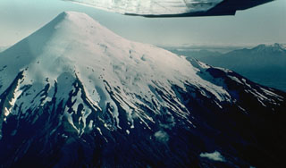 The symmetrical, glacier-clad Osorno stratovolcano forms a renowned landmark between Todos Los Santos and Llanguihue lakes. It is seen here from the north, with Calbuco volcano visible at the extreme right. The 2652-m-high Osorno is one of the most active volcanoes of the southern Chilean Andes. Flank scoria cones and fissure vents, primarily on the west and SW sides, have produced lava flows that reached Lago Llanguihue. Historical eruptions have originated from both summit and flank vents.
 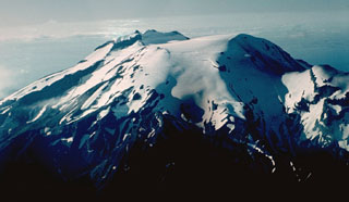 Calbuco is one of the most active volcanoes of the southern Chilean Andes. The isolated volcano rises to 2003 m south of Lake Llanquihue, which is visible at the upper right. The summit ridge (center) of the volcano is the remnant of an older volcano that collapsed during the late Pleistocene and produced a 3 cu km debris avalanche that reached the lake. Subsequent eruptions generated andesitic lava flows, breccias, and tuffs that filled the scarp and were subsequently topped by an historical lava-dome complex (right center).
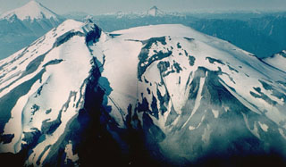 Along with its neighbor Osorno (upper left), Calbuco is one of the most active volcanoes of the southern Chilean Andes. The summit of Calbuco, seen at the left in this view from the SW, is the remnant of an older volcano that collapsed during the late Pleistocene, producing a debris avalanche that swept NNW into Lake Llanquihue. The smooth, snow-covered summit at the right is a young, historical lava-dome complex that postdates one of the largest historical eruptions in southern Chile during 1893-1894.
 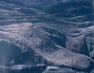 A blocky andesitic lava flow traveling at an average velocity of 4 meters per hour descended the Río Tepu valley on the NE flank of Calbuco during the 1961 eruption. Explosions and lava effusion began on February 1, and lahars caused extensive damage on the north flank, where they reached Lake Llanquihue. Lava flows traveled to the NE, NW, and SW, and a large explosion took place on March 10.
The following 1 samples associated with this volcano can be found in the Smithsonian's NMNH Department of Mineral Sciences collections, and may be availble for research (contact the Rock and Ore Collections Manager). Catalog number links will open a window with more information.
| Catalog Number | Sample Description | Lava Source | Collection Date |
|---|---|---|---|
| NMNH 118181 | Volcanic Ash | -- | 23 Apr 2015 |
| Copernicus Browser | The Copernicus Browser replaced the Sentinel Hub Playground browser in 2023, to provide access to Earth observation archives from the Copernicus Data Space Ecosystem, the main distribution platform for data from the EU Copernicus missions. |
| MIROVA | Middle InfraRed Observation of Volcanic Activity (MIROVA) is a near real time volcanic hot-spot detection system based on the analysis of MODIS (Moderate Resolution Imaging Spectroradiometer) data. In particular, MIROVA uses the Middle InfraRed Radiation (MIR), measured over target volcanoes, in order to detect, locate and measure the heat radiation sourced from volcanic activity. |
| MODVOLC Thermal Alerts | Using infrared satellite Moderate Resolution Imaging Spectroradiometer (MODIS) data, scientists at the Hawai'i Institute of Geophysics and Planetology, University of Hawai'i, developed an automated system called MODVOLC to map thermal hot-spots in near real time. For each MODIS image, the algorithm automatically scans each 1 km pixel within it to check for high-temperature hot-spots. When one is found the date, time, location, and intensity are recorded. MODIS looks at every square km of the Earth every 48 hours, once during the day and once during the night, and the presence of two MODIS sensors in space allows at least four hot-spot observations every two days. Each day updated global maps are compiled to display the locations of all hot spots detected in the previous 24 hours. There is a drop-down list with volcano names which allow users to 'zoom-in' and examine the distribution of hot-spots at a variety of spatial scales. |
|
WOVOdat
Single Volcano View Temporal Evolution of Unrest Side by Side Volcanoes |
WOVOdat is a database of volcanic unrest; instrumentally and visually recorded changes in seismicity, ground deformation, gas emission, and other parameters from their normal baselines. It is sponsored by the World Organization of Volcano Observatories (WOVO) and presently hosted at the Earth Observatory of Singapore.
GVMID Data on Volcano Monitoring Infrastructure The Global Volcano Monitoring Infrastructure Database GVMID, is aimed at documenting and improving capabilities of volcano monitoring from the ground and space. GVMID should provide a snapshot and baseline view of the techniques and instrumentation that are in place at various volcanoes, which can be use by volcano observatories as reference to setup new monitoring system or improving networks at a specific volcano. These data will allow identification of what monitoring gaps exist, which can be then targeted by remote sensing infrastructure and future instrument deployments. |
| Volcanic Hazard Maps | The IAVCEI Commission on Volcanic Hazards and Risk has a Volcanic Hazard Maps database designed to serve as a resource for hazard mappers (or other interested parties) to explore how common issues in hazard map development have been addressed at different volcanoes, in different countries, for different hazards, and for different intended audiences. In addition to the comprehensive, searchable Volcanic Hazard Maps Database, this website contains information about diversity of volcanic hazard maps, illustrated using examples from the database. This site is for educational purposes related to volcanic hazard maps. Hazard maps found on this website should not be used for emergency purposes. For the most recent, official hazard map for a particular volcano, please seek out the proper institutional authorities on the matter. |
| IRIS seismic stations/networks | Incorporated Research Institutions for Seismology (IRIS) Data Services map showing the location of seismic stations from all available networks (permanent or temporary) within a radius of 0.18° (about 20 km at mid-latitudes) from the given location of Calbuco. Users can customize a variety of filters and options in the left panel. Note that if there are no stations are known the map will default to show the entire world with a "No data matched request" error notice. |
| UNAVCO GPS/GNSS stations | Geodetic Data Services map from UNAVCO showing the location of GPS/GNSS stations from all available networks (permanent or temporary) within a radius of 20 km from the given location of Calbuco. Users can customize the data search based on station or network names, location, and time window. Requires Adobe Flash Player. |
| DECADE Data | The DECADE portal, still in the developmental stage, serves as an example of the proposed interoperability between The Smithsonian Institution's Global Volcanism Program, the Mapping Gas Emissions (MaGa) Database, and the EarthChem Geochemical Portal. The Deep Earth Carbon Degassing (DECADE) initiative seeks to use new and established technologies to determine accurate global fluxes of volcanic CO2 to the atmosphere, but installing CO2 monitoring networks on 20 of the world's 150 most actively degassing volcanoes. The group uses related laboratory-based studies (direct gas sampling and analysis, melt inclusions) to provide new data for direct degassing of deep earth carbon to the atmosphere. |
| Large Eruptions of Calbuco | Information about large Quaternary eruptions (VEI >= 4) is cataloged in the Large Magnitude Explosive Volcanic Eruptions (LaMEVE) database of the Volcano Global Risk Identification and Analysis Project (VOGRIPA). |
| EarthChem | EarthChem develops and maintains databases, software, and services that support the preservation, discovery, access and analysis of geochemical data, and facilitate their integration with the broad array of other available earth science parameters. EarthChem is operated by a joint team of disciplinary scientists, data scientists, data managers and information technology developers who are part of the NSF-funded data facility Integrated Earth Data Applications (IEDA). IEDA is a collaborative effort of EarthChem and the Marine Geoscience Data System (MGDS). |

