Report on Agung (Indonesia) — 22 November-28 November 2017
Smithsonian Institution / US Geological Survey
Weekly Volcanic Activity Report, 22 November-28 November 2017
Managing Editor: Sally Sennert.
Please cite this report as:
Global Volcanism Program, 2017. Report on Agung (Indonesia) (Sennert, S, ed.). Weekly Volcanic Activity Report, 22 November-28 November 2017. Smithsonian Institution and US Geological Survey.
Agung
Indonesia
8.343°S, 115.508°E; summit elev. 2997 m
All times are local (unless otherwise noted)
PVMBG reported that at 1730 on 25 November, after the number of volcanic earthquakes significantly increased, ash plumes rose 1.5 km above Agung’s crater rim and drifted 12 km WSW. Ashfall was reported in areas SW including Besakih (7 km SW), hamlets in the upper part of Pempatan (7.5 km W), and Temukus, prompting remaining residents to evacuate to the S. Eight inbound and 13 outbound international flights were cancelled, affecting 2,087 passengers. Crater incandescence was observed at 2100, signifying the presence of lava in the crater. BNPB noted that the number of evacuees was 25,016 (spread out in 224 shelters)
On 26 November dark gray ash plumes rose 2 km at 0505, 3 km at 0545, and 4 km at 0620, and drifted E and SE. Ash emissions continued throughout the day; a few explosions were heard within a 12-km radius. PVMBG issued a Volcano Observatory Notice for Aviation (VONA) elevating the Aviation Color Code from Orange to Red. Satellite data recorded sulfur dioxide gas concentrations ranging from 1,000 to 2,000 tons/day. Ashfall was reported in several areas downwind including North Duda (9 km S), Duda Timur (12 km S), Pempetan, Besakih, Sideman (15 km SSW), Tirta Abang, Sebudi (6 km SW), Amerta Bhuana (10 km SSW) in Klungkung, and some villages in Gianyar (20 km WSW). Ashfall was the thickest (5 mm) in Sibetan (11.5 km S). News sources noted that Lombok International Airport closed during 26-27 November.
PVMBG raised the Alert Level to 4 (the highest level on a scale of 1-4) on 27 November, and the exclusion zones were expanded to a general 8-km radius and to 10 km in the NNE, SE, S, and SW directions. Dense ash plumes continued to rise 2-4 km above the crater rim. Based on satellite data, the Darwin VAAC reported that ash plumes rose as high as 9.1 km (30,000 ft) a.s.l., or just over 6 km above the crater rim. Pictures and video showed a white steam plume adjacent to a gray ash plume rising form the crater, signifying two distinct active vents. According to news articles the Ngurah Rai International Airport in Bali closed due to the airborne ash. On 28 November BNPB noted that the number of evacuees had increased to 38,678, and were distributed in 225 evacuation centers. The Ngurah Rai International Airport reopened on 29 November, after the Aviation Color Code was lowered to Orange.
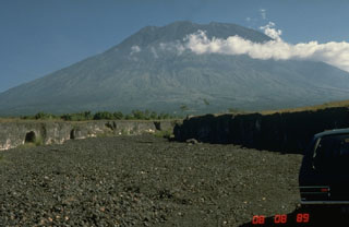
Geological Summary. Symmetrical Agung stratovolcano, Bali's highest and most sacred mountain, towers over the eastern end of the island. The volcano, whose name means "Paramount," rises above the SE rim of the Batur caldera, and the northern and southern flanks extend to the coast. The summit area extends 1.5 km E-W, with the high point on the W and a steep-walled 800-m-wide crater on the E. The Pawon cone is located low on the SE flank. Only a few eruptions dating back to the early 19th century have been recorded in historical time. The 1963-64 eruption, one of the largest in the 20th century, produced voluminous ashfall along with devastating pyroclastic flows and lahars that caused extensive damage and many fatalities.
Sources: Pusat Vulkanologi dan Mitigasi Bencana Geologi (PVMBG, also known as CVGHM), Badan Nacional Penanggulangan Bencana (BNPB), Darwin Volcanic Ash Advisory Centre (VAAC), CNN, The Sun

