Mount St. Helens 40th Anniversary — Hazard Communication
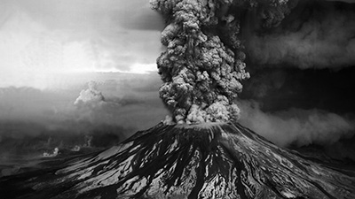
Forty years ago, on May 18th, 1980, Mount St. Helens produced the largest observed eruption in the coterminus United States. This eruption had profound impacts on human life and the science of volcanology, as well as on hazard preparedness, communication, and forecasting.
Teams for Hazard Communication
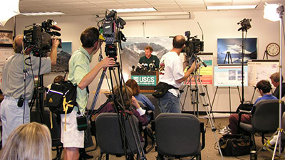
How do volcanologists communicate their findings and warn the public about these potential hazards? Making sure people stay safe during an eruption is possible with effective and practiced communication. Observatories work with local authorities to make sure local populations move out of harm’s way; they also work with the aviation community to make sure an airplane does not have a potentially deadly airborne encounter with an ash plume. Observatories and local authorities communicate a unified message to the public, media, and stakeholders.
|
Interview with Tina Neal, Scientist in Charge, USGS Hawaiian Volcano Observatory The role of scientists is to understand the volcano and what might happen as activity progresses. The response to help communities involves different agencies and different methods of communication. The US Geological Survey Hawaii Volcano Observatory Scientist in Charge Tina Neal talks about what this response looks like in the age of the internet and social media, with the 2018 Kilauea eruption as a modern example. |
Lessons Learned and Applied
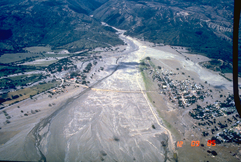
Volcano eruptions and the circumstances surrounding them are often unique. This makes forecasting eruptions difficult and the chain of communication can break down. Many lessons were learned and continue to be learned about forecasting and communication from eruptions like the 1980 eruption at Mt St Helens. Unfortunately, sometimes important lessons are born out of major disasters. In 1985 a small eruption at Nevado del Ruiz in Colombia led to a major lahar (the deadliest in recorded history) that swept through the town of Armero and cost 25,000 people their lives.
|
|
Aerial view of Armero destroyed by lahars from Nevado del Ruiz volcano, Colombia, on 13 November 1985. Public Domain image; https://www.usgs.gov/media/images/armero-destroyed-lahars-nevado-del-ruiz-volcano-colombia |
|
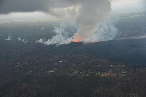
Fortunately, there are far more success stories about effective communication during an eruption that have saved property and precious lives. In 2018 activity at Kilauea intensified and a fissure opened in a neighborhood. Although property could not be saved from the extensive lava flows, no lives were lost due to the excellent communication and partnerships between the observatory, many local authorities, and the impacted residents. |
|
|
|
Morning overflight of Kīlauea Volcano's lower East Rift Zone by the Civil Air Patrol provides context for the location of the fissure 8 fountain and lava channel within the lower Puna District. View is to the north. Image courtesy of Civil Air Patrol. https://www.usgs.gov/media/images/k-laueas-lerz |
|
|
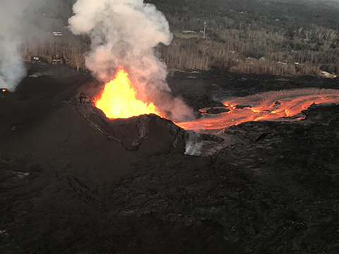
As of 0630 HST on 9 June 2018, fissure 8 continued to feed a vigorous channelized lava flow to the east of the vent. Overnight, fountain heights were generally 40–50 m (130-160 ft) high, with occasional bursts up to 60 m (just under 200 ft) high. Fallout from the fountains has built an asymmetric cinder-and-spatter cone around the vent, with the southwest side of the cone slightly higher (about 115 feet) than the northeast side (about 65 feet). This asymmetry reflects the prevailing trade winds, with more lava piling up on the downwind side of the fountains. (Public domain) https://www.usgs.gov/news/k-lauea-volcano-erupts |
Volcanic Ash
|
Interview with Claire Horwell, Professor of Geohealth in the Department of Earth Sciences, Durham University, UK and Director of the International Volcanic Health Hazard Network (IVHHN) Since the 1980 Mount St. Helens eruption volcanologists have learned a lot about volcanic ash and how it impacts many aspects of life, including human health. Volcanic ash can be a widespread product of volcanic eruptions and there is a lot of misunderstanding. Dr. Claire Horwell discusses what the health hazards are and the misconceptions about how volcanic ash impacts the health of people. For more information on volcanic ash and gas health impacts and what to do (with links to videos, pamphlets, and posters in different languages), go here: https://www.ivhhn.org/information |
Aviation Threats
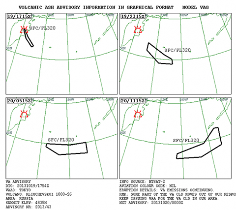
Explosive volcanic eruptions commonly produce ash plumes. Volcanic ash is not the same as fireplace ash or soot, but is instead fine particles of glass, minerals, and rock. Volcanic plumes can rise to altitudes exceeding 50,000 feet and disperse ash for hundreds or thousands of miles, and commercial aircraft fly at altitudes of ~30,000 feet, therefore volcanic eruptions present the unfortunate possibility for aircraft to encounter ash. Flying through volcanic ash can result in abrasion of forward-facing surfaces. Importantly, the melting temperature of volcanic ash is lower than the combustion temperature within turbine engines; as a result, ash ingested by an engine will melt and then re-solidify in cooler parts of the engine, potentially stalling the engine. To mitigate these hazards, volcano observatories and Volcanic Ash Advisory Centers (VAACs) monitor volcanoes around the world for ash emissions and issue alerts to redirect aircraft away from potential ash plumes.
|
|
Example of a Volcanic Ash Advisory graphic by the Tokyo VAAC for erupted from the Russian volcano Kliuchevskoi in 2013. Polygons show the expected (forecast) location of the ash cloud as it moves across the North Pacific airspace toward Alaska. https://volcanoes.usgs.gov/ |
Hazard Maps
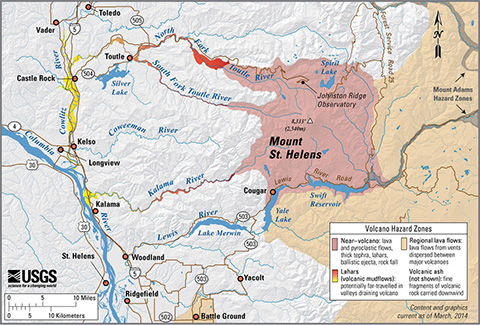
Volcanoes can produce a variety of hazards including ashfall, pyroclastic flows, lava flows, and lahars that can impact populations at local levels all the way up to global populations. These hazards and the risk they bring to lives and property can be represented to the public in a variety of ways including the hazard map. This is a special kind of map that shows what populations could be impacted by which kinds of hazards.
|
|
Mount St. Helens, Washington simplified hazards map showing potential impact area for ground-based hazards during a volcanic event. Mauve indicates areas at risk from lava flows and avalanches of hot rock and gases call pyroclastic flows. Bright red areas that fads to orange and yellow indicate potential routes for lahars (volcanic mudflows)? Not shown are areas subject to hazards from volcanic ash. Volcanic ashfall is often a nuisance but can be a more serious hazard during large explosive eruptions. https://www.usgs.gov/media/images/mount-st-helens-washington-simplified-hazards-map |