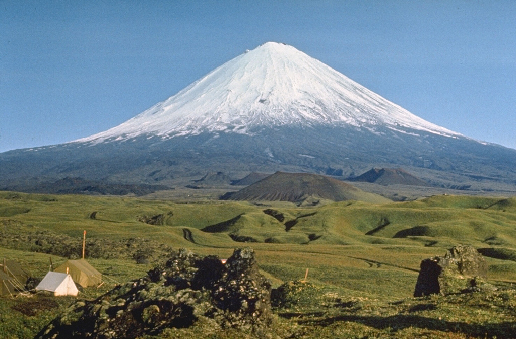
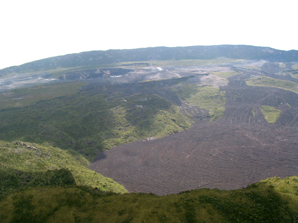
Fuego (Guatemala) | 4 June-10 June 2025 | New Activity / Unrest
 Cite this Report Cite this Report
|
 Fuego Fuego
Central America Volcanic Arc
|
The Instituto Nacional de Sismología, Vulcanologia, Meteorologia e Hidrología (INSIVUMEH) reported that elevated activity at Fuego on 4 June was characterized by lava fountaining, dense ash plumes, and pyroclastic density currents (PDCs). In a statement issued at 2030 on 4 June INSIVUMEH noted that there was a shift in eruption style to more effusive activity with abundant gas emissions and the ejection of incandescent material that covered the entire crater area and upper W flank. Lava fountaining became continuous, constant avalanches of material descended the flanks, and lava descended the Seca-Santa Teresa drainage (W) as far as 600 m. The activity continued through the night.
Just before 0500 on 5 June weak-to-moderate PDCs descended the Seca, Ceniza (SSW), and Las Lajas (SE) drainages. During 0500-1105 several more moderate-to-strong PDCs mainly descended the Las Lajas drainage, but also the Seca and Ceniza drainages, to as far as 7 km. Ash plumes rose from the summit and rose several hundred meters along the PDC tracks and drifted SW, W, and NW. Ashfall was reported in the municipalities of Acatenango (8 km E) and San Pedro Yepocapa (8 km NW) according to the Coordinadora Nacional para la Reducción de Desastres (CONRED). The Ministry of Environment and Natural Resources (SE-CONRED) issued an Orange Alert for the municipality of San Juan Alotenango and the municipality of Gimnasio. Ash plumes drifted as far as 60 km W and SW. By 1230 PDCs were also descending the La Trinidad (SSW) drainage. SE-CONRED announced that an Orange Alert was extended to the departments of Sacatepéquez, Chimaltenango, and Escuintla and classes were suspended at 43 schools in those departments. At around 1525 lahars that were possibly hot descended the El Jute (ESE) and Las Lajas drainages carrying tree branches, trunks, and blocks possibly as large as 3 m in diameter. By 1600 lahars were traveling down the Ceniza, Zarco, and Mazate rivers and again carried tree branches, trunks, volcanic material, and blocks possibly as large as 3 m in diameter. During the next hour additional lahars descended the Seca and Mineral (W) drainages, tributaries of the Pantaleón River. CONRED coordinated with Instituto Privado de Investigacio´n sobre Cambio Clima´tico (ICC) to evacuate about 600 residents in Panimaché I and II (8 km SW), El Rodeo (10 km SSE), Trinidad (21 km SE), and Morelia (9 km SW), though a news article noted that 700 had evacuated. A section of the National Route 14 (RN-14) was closed.
In a special report issued at 1925 On 5 June INSIVUMEH reported that PDCs continued to travel up to 7 km down multiple drainages. Ash-and-gas plumes from the PDCs rose several hundred meters high and drifted NW, W, and SW. By 0015 on 6 June a lava flow in the Ceniza drainage was 1.2 km long. Incandescent material on the SW flank was visible in webcam images. Ash from the descent of PDCs was not visible due to weather clouds around the volcano. Incandescent material was periodically ejected above the summit and landed on the flanks about 30 m from the crater rim. CONRED reported that activity significantly decreased during the early morning, after about 30 hours of the generation of lava flows, PDCs, and ash plumes. Incandescent material was no longer being ejected above the summit and ash was no longer suspended in the atmosphere based on webcam images.
During 6-7 June the seismic network recorded 4-6 explosions per hour. Ash-and-gas plumes rose as high as 1.1 km above the summit and drifted 10-30 km SW. Some explosions generated rumbling and shock waves. Incandescent material was ejected 200 m above the summit. Explosions during 8-9 June generated ash plumes that rose around 700 m above the summit and drifted 25 km W and SE. The explosions produced rumbling and shock waves, and generated block avalanches around the summit area and down various drainages. Weather clouds obscured views during 9-10 June, though infrasound instruments detected 2-8 explosions per hour. Faint sounds of blocks descending the flanks were reported and webcams captured incandescent blocks descending the Seca, Ceniza, and Las Lajas drainages. Ashfall was reported in several communities to the SW, including San Pedro Yepocapa, Panimaché I and II, Morelia, Santa Sofía (12 km SW), Los Yucales (12 km SW), and El Porvenir (8 km ENE).
Sources: Instituto Nacional de Sismologia, Vulcanologia, Meteorologia, e Hidrologia (INSIVUMEH), Coordinadora Nacional para la Reducción de Desastres (CONRED), TV Azteca Guate
|
Klyuchevskoy (Russia) | 4 June-10 June 2025 | New Activity / Unrest
Cite this Report
|
 Klyuchevskoy Klyuchevskoy
Eastern Kamchatka Volcanic Arc
|
The Kamchatkan Volcanic Eruption Response Team (KVERT) reported that a bright thermal anomaly at Klyuchevskoy was identified in satellite images during 29-30 May and 2-4 June. The Far Eastern Branch of the Russian Academy of Sciences (FEB RAS) reported that acoustic signals from explosive activity were periodically detected during the week. Ash plumes rose as high as 1.7 km above the summit and drifted SE and E during 30-31 May and 2-4 June. The Aviation Color Code remained at Orange (the second highest level on a four-color scale). Dates are based on UTC times; specific events are in local time where noted.
Sources: Kamchatkan Volcanic Eruption Response Team (KVERT), Institute of Volcanology and Seismology (IVS) of the Far Eastern Branch of the Russian Academy of Sciences (FEB RAS)
|
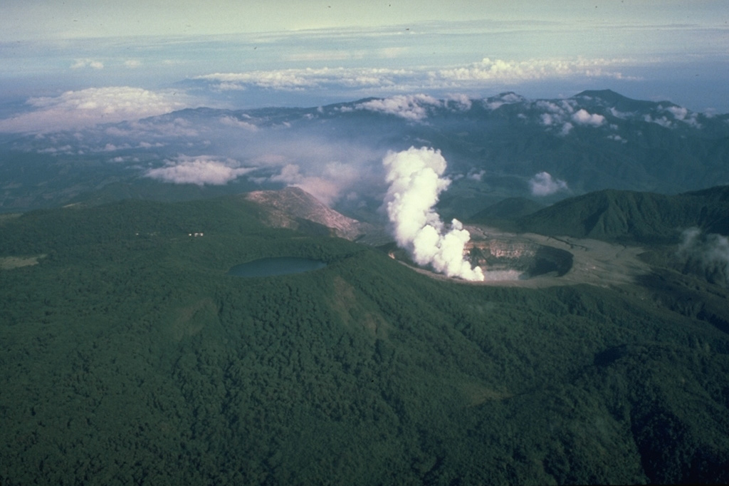
Aira (Japan) | 4 June-10 June 2025 | Continuing ActivityCite this Report |
 Aira Aira
Ryukyu Volcanic Arc
|
The Japan Meteorological Agency (JMA) reported ongoing eruptive activity at Minamidake Crater (Aira Caldera’s Sakurajima volcano) during 2-9 June. Nighttime crater incandescence was visible during 2-6 June. An explosion at 2341 on 2 June produced an ash plume that rose into weather clouds and ejected large blocks 300-1,000 m from the crater rim. Sulfur dioxide emissions averaged 1,800 tons per day on 4 June. Very small eruptive events were recorded during 6-9 June. The Alert Level remained at 3 (on a 5-level scale), and the public was warned to be cautious within 2 km of both the Minimadake and Showa craters.
Source: Japan Meteorological Agency (JMA)
|
Dieng Volcanic Complex (Indonesia) | 4 June-10 June 2025 | Continuing ActivityCite this Report |
 Dieng Volcanic Complex Dieng Volcanic Complex
Sunda Volcanic Arc
|
In a special report for the Dieng Volcanic Complex issued on 4 June the Pusat Vulkanologi dan Mitigasi Bencana Geologi (PVMBG) noted that carbon dioxide gas concentrations at Timbang Crater began to increase on 29 May. Seismicity did not increase. The Alert Level remained at 2 (on a scale of 1-4) and the public was warned to stay 500 m away from Sileri Crater, to not approach Timbang Crater, and to be vigilant when digging in the area due to risks of carbon dioxide gas exposure.
Source: Pusat Vulkanologi dan Mitigasi Bencana Geologi (PVMBG, also known as CVGHM)
|
Dukono (Indonesia) | 4 June-10 June 2025 | Continuing ActivityCite this Report |
 Dukono Dukono
Halmahera Volcanic Arc
|
The Pusat Vulkanologi dan Mitigasi Bencana Geologi (PVMBG) reported that eruptive activity at Dukono continued during 4-10 June. Daily white-and-gray gas-and-ash plumes rose 100-1,500 m above the summit and drifted E. Faint rumbling was heard at the observation post, 11 km N, during 6-7 June. Residents 10-11 km away hard occasional banging and rumbling sounds on 10 June. The Alert Level remained at Level 2 (on a scale of 1-4) and the public was warned to stay 4 km away from the Malupang Warirang Crater.
Source: Pusat Vulkanologi dan Mitigasi Bencana Geologi (PVMBG, also known as CVGHM)
|
Great Sitkin (United States) | 4 June-10 June 2025 | Continuing ActivityCite this Report |
 Great Sitkin Great Sitkin
Aleutian Ridge Volcanic Arc
|
The Alaska Volcano Observatory (AVO) reported that slow lava effusion continued to feed a thick flow in Great Sitkin’s summit crater during 4-10 June. The lava flow grew near the vent and advanced to the SE. Small daily earthquakes were detected by the seismic network, including signals probably caused by small rockfalls from the growing summit lava dome. Minor steaming and weakly elevated surface temperatures consistent with lava effusion were occasionally identified in satellite images. The Volcano Alert Level remained at Watch (the third level on a four-level scale) and the Aviation Color Code remained at Orange (the third color on a four-color scale).
Source: US Geological Survey Alaska Volcano Observatory (AVO)
|
Home Reef (Tonga) | 4 June-10 June 2025 | Continuing ActivityCite this Report |
 Home Reef Home Reef
Tofua Volcanic Arc
|
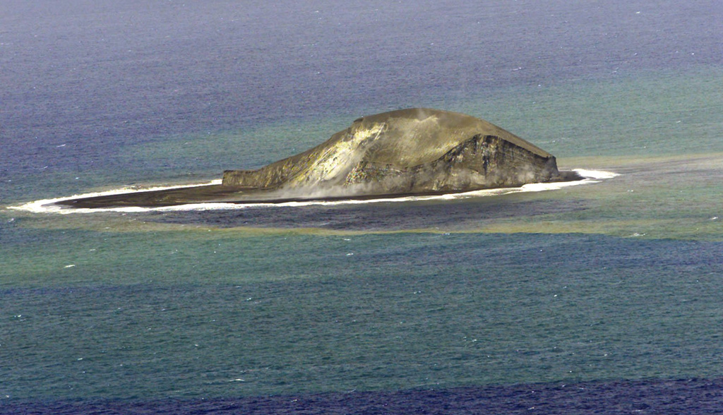
The Tonga Geological Services reported that the eruption at Home Reef continued during 24 May-7 June. Satellite images from 27 May showed explosive activity with an ash-and-gas plume rising from an enlarged crater and drifting around 20 km SE. Thermal data after that event showed a drop in heat output, and effusion and explosive activity stopped. Shadows created by the plume made crater size estimates difficult, but a clear satellite view on 1 June showed that it was about 110 x 245 m. There were also three landslide areas, on the E, NW, and SW coasts, originating from the flanks of the cone that may have occurred during the 27 May activity. The Aviation Color Code remained at Yellow (the second lowest level on a four-level scale, the Maritime Alert Level remained at Orange (the third level on a four-level scale) with advice to stay at least 2 nautical miles (3.7 km) from the island, and the Alert Level for residents of Vava’u and Ha’apai remained at Green (the first level on a four-level scale).
Source: Tonga Geological Services, Government of Tonga
|
Ibu (Indonesia) | 4 June-10 June 2025 | Continuing ActivityCite this Report |
 Ibu Ibu
Halmahera Volcanic Arc
|
The Pusat Vulkanologi dan Mitigasi Bencana Geologi (PVMBG) reported that the eruption at Ibu continued during 4-10 June. Daily gray or white-to-gray ash plumes rose 300-700 m above the summit and drifted NE, E, and SE. Nighttime crater incandescence was visible in some webcam images. Weather clouds sometimes obscured views. The Alert Level remained at 3 (the second highest level on a four-level scale) and the public was advised to stay 4 km away from the active crater and 5 km away from the N crater wall opening.
Source: Pusat Vulkanologi dan Mitigasi Bencana Geologi (PVMBG, also known as CVGHM)
|
Kanlaon (Philippines) | 4 June-10 June 2025 | Continuing ActivityCite this Report |
 Kanlaon Kanlaon
Negros-Sulu Volcanic Arc
|
The Philippine Institute of Volcanology and Seismology (PHIVOLCS) reported continuing unrest at Kanlaon during 3-9 June. The seismic network recorded 3-26 daily volcanic earthquakes. Daily sulfur dioxide emissions ranged from 1,355 to 5,324 tonnes per day. Gas-and-steam emissions of variable densities generally rose as high as 900 m above the crater rim and drifted in various directions. According to the Tokyo VAAC PHIVOLCS reported that at 0203 on 5 June an ash plume rose 3.7 km (12,000 ft) a.s.l., or about 1.3 km above the summit. Ash was not identified in satellite images. The Civil Defense PH issued a notice to be aware of potential ashfall in surrounding areas. On 6 June heavy rains generated cement-like lahars on the S and SW flanks, along the Buhangin River (which flows through La Castellana and Moises Padilla), along the Sitio San Luis River, and beneath the Hacienda 92 Bridge in Barangay Sag-ang, and along the Ibid Creek in Barangay Biak-na-bato, La Castellana. The Alert Level remained at 3 (on a scale of 0-5); the public was warned to stay 6 km away from the summit and pilots were warned not to fly close to the volcano.
Sources: Philippine Institute of Volcanology and Seismology (PHIVOLCS), Office of Civil Defense, Republic of the Philippines
|
Karymsky (Russia) | 4 June-10 June 2025 | Continuing ActivityCite this Report |
 Karymsky Karymsky
Eastern Kamchatka Volcanic Arc
|
The Kamchatkan Volcanic Eruption Response Team (KVERT) reported that moderate activity continued at Karymsky during 29 May-5 June. A daily thermal anomaly over the volcano was identified in satellite images. The Aviation Color Code remained at Orange (the third level on a four-color scale). Dates are based on UTC; specific events are in local time where noted.
Source: Kamchatkan Volcanic Eruption Response Team (KVERT)
|
Kilauea (United States) | 4 June-10 June 2025 | Continuing ActivityCite this Report |
 Kilauea Kilauea
Hawaiian-Emperor Hotspot Volcano Group
|
The Hawaiian Volcano Observatory (HVO) reported that the eruption within Kilauea’s Kaluapele summit caldera, characterized by episodic fountaining and intermittent spatter at two vents along the SW margin of Halema’uma’u Crater, continued at variable levels during 4-10 June. Night incandescence, intermittent lava spattering, gas pistoning, and hydrogen flames at the N vent were visible during 3-4 June. Minimal incandescence at the S vent was observed. Low dome fountaining began at the N vent at around 2055 on 4 June and was accompanied by lava overflows onto the crater floor. Small sustained lava fountains, less than about 30 m high, began erupting at the N vent around 2115. The activity intensified with fountains rising to 100 m by 2210 and over 300 m by 2240. An eruption plume rose 5 km above the ground level by 2250 and was continuing to rise. Sulfur dioxide emissions were estimated at 50,000-75,000 tonnes per day. Large lava flows erupted from both vents and covered about half of Halema’uma’u Crater floor. The N vent stopped erupting at about 0408 on 5 June and the S vent stopped shortly after at 0428. HVO warned that strands of Pele’s hair, present throughout the summit area of Hawai’i Volcanoes National Park and surrounding communities, could be remobilized by wind. Data analysis confirmed that lava fountains rose as high as 365 m, a new record high for the current eruption that began in December 2024. Tephra deposits from the period of high fountaining were several meters thick on the SW rim of Kaluapele, in a closed area of the park, and as much as 60 cm of tephra was deposited at a location 2.4 km SW of the eruptive vents.
Incandescence at the S vent was visible overnight during 7-8 June. Vigorous sulfur dioxide gas emissions, nighttime incandescence, and occasional spatter at the N vent indicated that magma was close to the surface during 8-9 June. Spattering at the N vent became continuous during the early hours on 10 June, followed around 0554 by lava overflows onto the crater floor. The vent continued to generate lava flows during gas pistoning events at least through 1000. The Volcano Alert Level remained at Watch (the third level on a four-level scale) and the Aviation Color Code remained at Orange (the third color on a four-color scale).
Source: US Geological Survey Hawaiian Volcano Observatory (HVO)
|
Lewotolok (Indonesia) | 4 June-10 June 2025 | Continuing ActivityCite this Report |
 Lewotolok Lewotolok
Sunda Volcanic Arc
|
The Pusat Vulkanologi dan Mitigasi Bencana Geologi (PVMBG) reported that an eruption at Lewotolok was ongoing during 4-10 June. Gray or white-to-gray ash plumes rose 500-700 m above the summit of the cone and drifted NW, W, and SW during 4-5 and 8-9 June. Clear nighttime webcam images showed incandescent material at the summit cone, being ejected above the summit cone, and on the upper flanks. Lava effusion increased on 4 June and flows were descending three flanks. By 5 June the S flow was 700 m from the crater rim, the SE flow was 1 km from the crater rim, and the W flow was 300 m from the crater rim. A drone overflight was conducted on 7 June; the SE flow had advanced 200 m for a total length of 1.2 km, indicating a slower advancement rate. The Alert Level remained at 2 (on a scale of 1-4) and the public was warned to stay 2 km away from the vent and 2.5 km away on the S, SE, and W flanks.
Source: Pusat Vulkanologi dan Mitigasi Bencana Geologi (PVMBG, also known as CVGHM)
|
Merapi (Indonesia) | 4 June-10 June 2025 | Continuing ActivityCite this Report |
 Merapi Merapi
Sunda Volcanic Arc
|
The Balai Penyelidikan dan Pengembangan Teknologi Kebencanaan Geologi (BPPTKG) reported that the eruption at Merapi (on Java) continued during 30 May-5 June. Seismicity remained at high levels, similar to the previous week. The SW lava dome produced 20 lava avalanches that traveled as far as 1.9 km SW down the Bebeng drainage, 14 that traveled as far as 2 km SW down the Krasak drainage, and 39 that traveled as far as 2 km W down the Sat/Putih drainage. Small morphological changes to the SW lava dome resulted from continuing effusion and minor collapses. The hottest temperature at the SW dome was 247.4 degrees Celsius, the same as the previous measurement, and the volume of the dome increased by 52,500 cubic meters to an estimated 4,049,300 cubic meters, based on webcam images and a 30 May drone survey. The size of the central dome had not changed, and the highest temperature remained relatively stable at 217.9 degrees Celsius. The Alert Level remained at 3 (on a scale of 1-4), and the public was warned to stay 3-7 km away from the summit, based on location.
Source: Balai Penyelidikan dan Pengembangan Teknologi Kebencanaan Geologi (BPPTKG)
|
Nyamulagira (DR Congo) | 4 June-10 June 2025 | Continuing ActivityCite this Report |
 Nyamulagira Nyamulagira
Albertine Rift Volcanic Province
|
A satellite image acquired on 10 June showed continuing eruptive activity at Nyamulagira. Bright thermal anomalies indicated continuing activity at the summit crater and active lava flows on the W and NW flanks, though weather clouds obscured views. A thermal anomaly at the possible end of a lava flow on the NW flank was about 3.3 km from the crater rim.
Source: Copernicus
|
Poas (Costa Rica) | 4 June-10 June 2025 | Continuing ActivityCite this Report |
 Poas Poas
Central America Volcanic Arc
|
The Observatorio Vulcanológico y Sismológico de Costa Rica-Universidad Nacional (OVSICORI-UNA) reported continuing gas-and-steam emissions with occasional ash at Poás during 3-10 June. Significant amounts of gas-and-steam emissions were continuously and vigorously emitted at both Boca A and Boca C vents during the week, though there was a decreasing trend in the contribution of magmatic gases. Sulfur dioxide emissions decreased, though remained at high levels; the emissions were bluish in webcam images on 3 June and averaged 395 tonnes per day in satellite data on 4 June. Incandescence continued to be visible and detected in infrared webcam views at Boca A vent. The steam-and-gas plumes on 2 June contained minor amounts of ash. The steam-and-gas emissions at Boca A began to contain a moderate amount of ash at 0340 on 10 June and the ash content persisted for a few hours. The plumes rose as high as 1 km above the vent and drifted W. The volcano’s Alert Level remained at 3 (the second highest level on a four-level scale) and the Aviation Color Code remained at Orange (the second highest color on a four-color scale).
Source: Observatorio Vulcanologico y Sismologico de Costa Rica-Universidad Nacional (OVSICORI-UNA)
|
Raung (Indonesia) | 4 June-10 June 2025 | Continuing ActivityCite this Report |
 Raung Raung
Sunda Volcanic Arc
|
The Pusat Vulkanologi dan Mitigasi Bencana Geologi (PVMBG) reported that ash was present in emissions at Raung during 5-7 June. Emissions became continuous around 0600 on 5 June. The ash-bearing white to medium-gray plumes rose 600 m above the summit and drifted NE. Seismic energy did not increase and deformation data showed subsidence, suggesting that the source of the emissions was relatively shallow. Gray gas-and-ash plumes were continuous on 7 June, and possibly continuous at least through 2329 on 8 June, rising to 400 m above the crater rim. Ashfall was reported in the Linggusar and Sumberwringin area, Bondowoso Regency, about 17 km NNW. The Alert Level remained at 2 (on a scale of 1-4) and the public was warned to stay 3 km away from the summit crater.
Source: Pusat Vulkanologi dan Mitigasi Bencana Geologi (PVMBG, also known as CVGHM)
|
Reventador (Ecuador) | 4 June-10 June 2025 | Continuing ActivityCite this Report |
 Reventador Reventador
Northern Andean Volcanic Arc
|
The Instituto Geofísico-Escuela Politécnica Nacional (IG-EPN) reported that eruptive activity continued at Reventador during 3-10 June. Seismicity included 61-79 daily explosions, long-period earthquakes, harmonic tremor, and tremor associated with emissions. Multiple daily ash-and-gas plumes rose 200-1,200 m above the crater rim and drifted mainly NW, W, and SW. Webcams recorded multiple nightly instances of incandescent material descending the flanks as far as 1.1 km below the crater rim, specifically down the SE and ESE flanks during 4-5 June and the S flanks during 9-10 June. Starting at 1631 on 6 June a moderate-sized lahar descended the N flank based on seismic data. Weather clouds occasionally obscured views. Secretaría de Gestión de Riesgos (SGR) maintained the Alert Level at Orange (the second highest level on a four-color scale).
Sources: Instituto Geofísico-Escuela Politécnica Nacional (IG-EPN), Secretaría de Gestión de Riesgos (SGR)
|
Sangay (Ecuador) | 4 June-10 June 2025 | Continuing ActivityCite this Report |
 Sangay Sangay
Northern Andean Volcanic Arc
|
The Instituto Geofísico-Escuela Politécnica Nacional (IG-EPN) reported high levels of eruptive activity at Sangay during 3-10 June. The seismic network recorded 39-135 daily explosions. Daily ash-and-gas plumes were observed in webcam and/or satellite images rising as high as 2.2 km above the summit and drifting mainly NW, W, and SW. Weather clouds often obscured webcam observations. Several incandescent avalanches of material descended the SE flank as far as 1 km during 9-10 June. Secretaría de Gestión de Riesgos (SGR) maintained the Alert Level at Yellow (the second highest level on a four-color scale).
Sources: Instituto Geofísico-Escuela Politécnica Nacional (IG-EPN), Secretaría de Gestión de Riesgos (SGR), Washington Volcanic Ash Advisory Center (VAAC)
|
Semeru (Indonesia) | 4 June-10 June 2025 | Continuing ActivityCite this Report |
 Semeru Semeru
Sunda Volcanic Arc
|
The Pusat Vulkanologi dan Mitigasi Bencana Geologi (PVMBG) reported that activity continued at Semeru during 4-10 June, often with multiple daily eruptive events recorded by the seismic network. White-and-gray ash plumes rose 300-1,000 m above the summit and drifted N and NW; no plumes were visible during 8-9 June. The Alert Level remained at 2 (the second lowest level on a scale of 1-4). The public was warned to stay at least 3 km away from the summit in all directions, 8 km from the summit to the SE, 500 m from the banks of the Kobokan drainage as far as 13 km from the summit, and to avoid other drainages including the Bang, Kembar, and Sat, due to lahar, avalanche, and pyroclastic flow hazards.
Source: Pusat Vulkanologi dan Mitigasi Bencana Geologi (PVMBG, also known as CVGHM)
|
Sheveluch (Russia) | 4 June-10 June 2025 | Continuing ActivityCite this Report |
 Sheveluch Sheveluch
Eastern Kamchatka Volcanic Arc
|
The Kamchatkan Volcanic Eruption Response Team (KVERT) reported that lava extrusion may have continued at Sheveluch’s “300 years of RAS” dome on the SW flank of Old Sheveluch and at the Young Sheveluch dome during 29 May-5 June. Daily thermal anomalies over the domes were identified in satellite images. The Far Eastern Branch of the Russian Academy of Sciences (FEB RAS) reported that minor steam, gas, and ash plumes rose as high as 4 km (13,100 ft) a.s.l. drifted SE, E, NW, and W on most days. The Aviation Color Code remained at Orange (the second highest level on a four-color scale). Dates are based on UTC; specific events are in local time where noted.
Sources: Kamchatkan Volcanic Eruption Response Team (KVERT), Institute of Volcanology and Seismology (IVS) of the Far Eastern Branch of the Russian Academy of Sciences (FEB RAS)
|
Suwanosejima (Japan) | 4 June-10 June 2025 | Continuing ActivityCite this Report |
 Suwanosejima Suwanosejima
Ryukyu Volcanic Arc
|
The Japan Meteorological Agency (JMA) reported that eruptive activity at Suwanosejima's Ontake Crater continued during 2-9 June. Incandescence was observed nightly in webcam images. No explosions were detected, though ash-and-gas emissions were continuous during 4-7 June. The plumes rose as high as 1.3 km above the crater rim and blocks were ejected 300 m from the vent. Ashfall was reported by the Suwanosejima Branch of the Toshima Village Office (3.5 km SSW) on 5 June. The Alert Level remained at 2 (the second level on a five-level scale) and the public was warned to be cautious within 1.5 km of the crater.
Source: Japan Meteorological Agency (JMA)
|
Tangkuban Parahu (Indonesia) | 4 June-10 June 2025 | Continuing ActivityCite this Report |
 Tangkuban Parahu Tangkuban Parahu
Sunda Volcanic Arc
|
The Pusat Vulkanologi dan Mitigasi Bencana Geologi (PVMBG) reported increased unrest at Tangkuban Parahu during late May-early June. Steam-and-gas plumes rose as high as 110 m above the vents in Ratu Crater. The seismic network recorded an increase in signals indicating gas venting to 21-37 events per day during 30 May-1 June and a total of 100 low-frequency events that suggested the movement of fluids to shallow depths. During 1-8 June steam-and-gas plumes rose as high as 150 m above the vents at Ratu Crater and 5-10 m above the vents at Ecoma Crater. Continuous tremor began at around 2200 on 5 June and was coincident with bubbling or boiling mud Ratu, where black mud deposits surrounded the pool. Thermal areas at both Ratu and Ecoma craters imaged by drone showed no enlargement of the thermal areas between 5 and 7 June. The seismic network recorded 16 and 3 low-frequency events on 7 and 8 June, respectively; seismicity remained elevated through 8 June. Deformation data indicted continuing inflation. As of 8 June the proportions of gas species had not shown notable changes, and gas concentrations were within normal limits. The Alert Level remained at 1 (on a scale of 1-4) and tourists were advised not to descend into the craters.
Source: Pusat Vulkanologi dan Mitigasi Bencana Geologi (PVMBG, also known as CVGHM)
|
Whakaari/White Island (New Zealand) | 4 June-10 June 2025 | Continuing ActivityCite this Report |
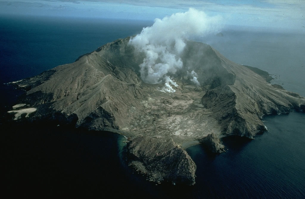 Whakaari/White Island Whakaari/White Island
Taupo Volcanic Arc
|
On 9 June GeoNet reported that a minor volcanic eruption had been going on at Whakaari/White Island since 19 April, though no ash had been detected in the emissions during the previous four weeks. Observations from webcams located at Whakatane and Te Kaha and analysis of satellite data over the past four weeks, and a monitoring flight on 9 June, all gave confirmation that the eruption had stopped. The Volcanic Alert Level was lowered to 2 (on a scale of 0-5) and the Aviation Color Code was lowered to Yellow (the second lowest level on a four-color scale) on 9 June. GeoNet stated that the Alert Levels were reflective of the current level of activity, but there was uncertainty due to the lack of consistent, usable, real-time monitoring data; GeoNet relies on remote cameras, satellite images, and periodic overflights to monitor Whakaari.
Source: GeoNet
|
