Report on Semeru (Indonesia) — January 1994

Bulletin of the Global Volcanism Network, vol. 19, no. 1 (January 1994)
Managing Editor: Richard Wunderman.
Semeru (Indonesia) Lava avalanches and pyroclastic flows kill six people
Please cite this report as:
Global Volcanism Program, 1994. Report on Semeru (Indonesia) (Wunderman, R., ed.). Bulletin of the Global Volcanism Network, 19:1. Smithsonian Institution. https://doi.org/10.5479/si.GVP.BGVN199401-263300
Semeru
Indonesia
8.108°S, 112.922°E; summit elev. 3657 m
All times are local (unless otherwise noted)
On 3 February, VSI observers and local residents near Semeru heard a sharp thunder-clap at 0350 and later saw falling ash. Lava avalanches and pyroclastic flows from the summit crater descended SE along the Kembar and Kobokan rivers, reaching 7.5 km and 11.5 km from the summit, respectively. Volcanic materials also entered Sumbersari village (8 km SE of the summit), located between the rivers. Four people were killed; another three were injured, and two of those later died. Following the lava avalanches and pyroclastic flows, 275 people were evacuated from Sumbersari, where many houses and 1.5 km2 of plantation land were destroyed. A seismic station maintained by VSI was also destroyed.
Visual and seismic activity had increased in late 1993, with frequent collapses from the summit lava flow SE into the area between the Kembar and Kobokan rivers. Volcanic earthquakes had been recorded since October, and peaked on 25 December 1993. Continuous tremor with a maximum amplitude of 26 mm was recorded from 26 January until 3 February 1994 (figure 4).
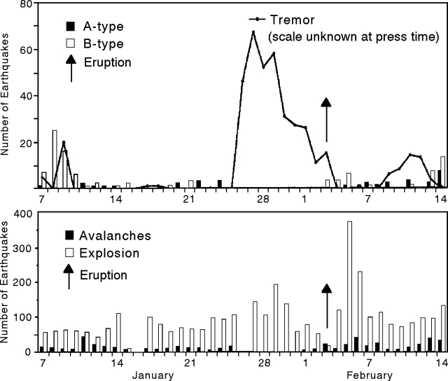 |
Figure 4. Diagram showing seismicity at Semeru, 7 January-14 February 1994, with A- and B-type events along with tremor (top), and avalanche and explosion events (bottom). Courtesy of VSI. |
Eruptive and seismic activity continued after 3 February, but the intensity and energy had decreased. The daily number of explosion earthquakes increased to 360 on 5 February, then declined again, but remained >70/day through mid-month (figure 4). Volcanic tremor was recorded again on 9-14 February with a maximum amplitude of 13 mm. Ash eruptions generated clouds reaching heights of up to 700 m above the summit. Pyroclastic flows and lava avalanches traveled as far as 3 km down the Kembar and Kobokan rivers. Lava extruded from the crater over the S rim formed a 750-m-long lobe moving down the S flank toward the Kembar river.
Geological Summary. Semeru, the highest volcano on Java, and one of its most active, lies at the southern end of a volcanic massif extending north to the Tengger caldera. The steep-sided volcano, also referred to as Mahameru (Great Mountain), rises above coastal plains to the south. Gunung Semeru was constructed south of the overlapping Ajek-ajek and Jambangan calderas. A line of lake-filled maars was constructed along a N-S trend cutting through the summit, and cinder cones and lava domes occupy the eastern and NE flanks. Summit topography is complicated by the shifting of craters from NW to SE. Frequent 19th and 20th century eruptions were dominated by small-to-moderate explosions from the summit crater, with occasional lava flows and larger explosive eruptions accompanied by pyroclastic flows that have reached the lower flanks of the volcano.
Information Contacts: W. Tjetjep, VSI; A. Brodsholl, GMU.