Report on Nyiragongo (DR Congo) — June 1994

Bulletin of the Global Volcanism Network, vol. 19, no. 6 (June 1994)
Managing Editor: Richard Wunderman.
Nyiragongo (DR Congo) Lava lake active again after 11 years
Please cite this report as:
Global Volcanism Program, 1994. Report on Nyiragongo (DR Congo) (Wunderman, R., ed.). Bulletin of the Global Volcanism Network, 19:6. Smithsonian Institution. https://doi.org/10.5479/si.GVP.BGVN199406-223030
Nyiragongo
DR Congo
1.52°S, 29.25°E; summit elev. 3470 m
All times are local (unless otherwise noted)
[The following was extracted from a combined Nyiragongo/Nyamuragira report.] After approximately 11 years of quiet, eruptive activity from the summit crater of Nyiragongo began again on 23 June, feeding a new lava lake. This stratovolcano in eastern Zaire is ~18 km N of Goma, the city where the major encampment of Rwandan civil-war refugees is located (figure 5).
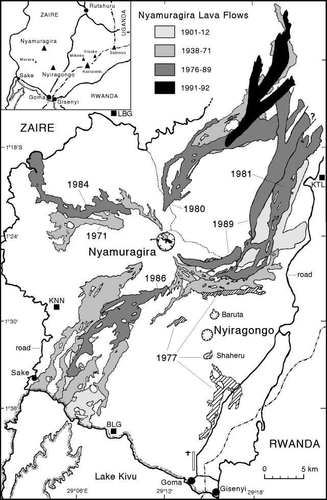 |
Figure 5. Map showing lava flows from Nyiragongo (1977; hatched) and Nyamuragira (1900-1992; shaded). Political boundaries (dash-dot lines) and roads (heavy solid lines) are approximate and not intended to be definitive. Solid squares indicate locations of seismic stations. Dots show cities. Modified from maps provided by N. Zana. |
Several journalists reported red glow above Nyiragongo at night. A Dutch doctor who visited the summit . . . stated that a new crater had formed in the old lava lake and was emitting "black dust" and needle-like crystals that were 5-7 cm long. Another press report on 12 July quoted aid workers who described "spitting fire from parasitic cones and fissures" on Nyiragongo's slopes, but there have been no other reports of lava flows outside of the summit crater at Nyiragongo. Press reports through 24 July continued to mention volcanic "smoke" or "dust" falling in the refugee camps.
[TOMS data showing high SO2 values over the volcanoes was later interpreted to be from a nearly simultaneous eruption at Nyamuragira (see 19:07)]
Reference. Zana, N., Kasahara, M., Kasereka, M., Azangi, M., and Wafula, M., 1993, Surface deformations and seismic activities related to the 1991-1992 Nyamuragira eruption: IAVCEI, Canberra Meeting Abstracts, p. 127.
Geological Summary. The Nyiragongo stratovolcano contained a lava lake in its deep summit crater that was active for half a century before draining catastrophically through its outer flanks in 1977. The steep slopes contrast to the low profile of its neighboring shield volcano, Nyamuragira. Benches in the steep-walled, 1.2-km-wide summit crater mark levels of former lava lakes, which have been observed since the late-19th century. Two older stratovolcanoes, Baruta and Shaheru, are partially overlapped by Nyiragongo on the north and south. About 100 cones are located primarily along radial fissures south of Shaheru, east of the summit, and along a NE-SW zone extending as far as Lake Kivu. Many cones are buried by voluminous lava flows that extend long distances down the flanks, which is characterized by the eruption of foiditic rocks. The extremely fluid 1977 lava flows caused many fatalities, as did lava flows that inundated portions of the major city of Goma in January 2002.
Information Contacts: H. Hamaguchi and M. Kasereka, Tohoku Univ; M. Akumbi, CRSN, Goma; N. Zana, Centre de Recherche en Géophysique, Kinshasa; J. Durieux, GEVA, Lyon, France; I. Sprod, GSFC; Reuters; AP; Agence France Press.