Report on Shikotsu (Japan) — July 1996
Bulletin of the Global Volcanism Network, vol. 21, no. 7 (July 1996)
Managing Editor: Richard Wunderman.
Shikotsu (Japan) Seismic activity increases
Please cite this report as:
Global Volcanism Program, 1996. Report on Shikotsu (Japan) (Wunderman, R., ed.). Bulletin of the Global Volcanism Network, 21:7. Smithsonian Institution. https://doi.org/10.5479/si.GVP.BGVN199607-285040
Shikotsu
Japan
42.688°N, 141.38°E; summit elev. 1320 m
All times are local (unless otherwise noted)
The number of volcanic earthquakes beneath Tarumai stratovolcano (on the rim on Shikotsu caldera) increased in June and July. There were 13 events on both 8 and 10 June. A total of 64 earthquakes was recorded in July.
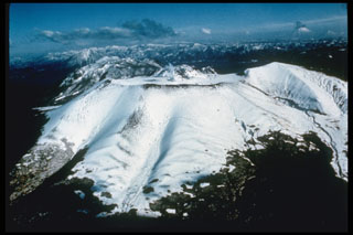
Geological Summary. The 13 x 15 km Shikotsu caldera, largely filled by the waters of Lake Shikotsu, was formed during one of Hokkaido's largest Quaternary eruptions about 31-34,000 years ago. The small andesitic Tarumaesan stratovolcano was then constructed on its SE rim and has been frequently active in historical time. Pyroclastic-flow deposits from Tarumaesan extend nearly to the Pacific coast. Two other Holocene post-caldera volcanoes, Fuppushidake (adjacent to Tarumaesan) and Eniwadake (on the opposite side of the caldera), occur on a line trending NW from Tarumaesan, and were constructed just inside the caldera rim. Minor eruptions took place from the summit of Eniwadake as late as the 17th century. The summit of Tarumaesan contains a small 1.5-km-wide caldera formed during two of Hokkaido's largest historical eruptions, in 1667 and 1739. Tarumaesan is now capped by a flat-topped summit lava dome that formed in 1909.
Information Contacts: Volcanological Division, Japan Meteorological Agency, 1-3-4 Ote-machi, Chiyoda-ku, Tokyo 100, Japan