Report on Reventador (Ecuador) — November 2004

Bulletin of the Global Volcanism Network, vol. 29, no. 11 (November 2004)
Managing Editor: Richard Wunderman.
Reventador (Ecuador) Late 2004 visits find renewed venting and thick intracaldera lava flows 2 km long
Please cite this report as:
Global Volcanism Program, 2004. Report on Reventador (Ecuador) (Wunderman, R., ed.). Bulletin of the Global Volcanism Network, 29:11. Smithsonian Institution. https://doi.org/10.5479/si.GVP.BGVN200411-352010
Reventador
Ecuador
0.077°S, 77.656°W; summit elev. 3562 m
All times are local (unless otherwise noted)
A 16 December 2004 report from the Instituto Geofísico (IG) of the Escuela Politécnica Nacional calls attention to renewed lava effusion from the crater that lies within Reventador's large summit cone (figure 13). A block-lava flow escaped the cone's crater. It ran out at a breach in the S wall, and by 16 December it had advanced ~ 2 km farther. The flow advanced SE along a narrow, E-curving path, remaining atop lavas from 2002. Thus far in 2004, lava flows remained well within the larger caldera.
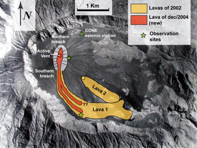 |
Figure 13. An aerial photo of Reventador's 4-km-diameter caldera as a base for mapping the lava flows of 2002 and those of 2004 through mid-December. The 2002 flows are labeled Lava 1 and Lava 2. The 2004 lava flow followed and partly covered Lava 1. At a distance of ~ 1 km from the vent, the 2004 lava flow bifurcated into two closely spaced parallel lobes. The caldera has an E-tilting floor, is open on its E side, and contains a prominent cone on its W side. The cone forms the volcano's summit, and contains an elongate crater that hosts the 2004 vent ("active vent"). The crater has a rim that is indicated by a solid curving line; the crater's inward-sloping walls are indicated by light shading and lines resembling the trends of gullies. The cone's floor at its southern breach lies at ~ 3,200 m elevation. The aerial photo was taken by Instituto Geográfico Militar in 1983. Figure courtesy of IG. |
Reports in 2003 chiefly discussed events outside the caldera. A road, one gas pipeline, and two oil pipelines traverse Reventador's flanks 7 km ESE of the active vent. All of these installations were affected in 2003 (but not appreciably since then). The pipelines were destroyed due to heavy lahars coming down the Reventador river on 6 May 2003 (BGVN 28:06). Our last report (BGVN 28:11) discussed events during July through most of November 2003.
Lava venting in the crater likely began in early November 2004, a time when seismic station CONE registered dramatic increases in volcano-tectonic events (figure 14). In response to the elevated seismicity, the IG-EPN began more intensive monitoring, including overflights with thermal imaging, repeat visits to the remote volcano, and on 9 November 2004, installation of the additional short-period seismic station LAV3, ~ 2 km from the crater's vent.
 |
Figure 14. Seismicity (number of earthquakes) versus time registered at Reventador (station CONE) during mid-February 2003 through mid-December 2004. Anomalously elevated seismicity consisting mainly of volcano-tectonic began in August 2004. Activity increased on 4 November 2004 and included hybrid events. Previously unseen emergent, extended-duration, broad-band earthquakes began on 22 November 2004. Courtesy of IG. |
A helicopter overflight by IG-EPN staff on 10 November 2004 confirmed the presence of a small lava dome, which appeared then to be confined to the crater floor. This feature was not present on photos taken during an IG overflight on 19 October 2004. During the 10 November overflight, a continuous 2.5 km-high gas column escaped from the crater, accompanied by sulfurous odors detected by personnel in the helicopter.
The date when lava began escaping the crater was not precisely known, but it was thought to have been around 22 November, coincident with the emergence of distinct seismic signals not previously observed at Reventador (figure 11). The signals occurred in swarms and consisted of low-frequency (1-10 Hz) waves of relatively low-amplitude. Their seismic records were emergent (i.e. growing in amplitude with time) and of long duration (up to 60 seconds). They are thought to have been possibly associated with rock falls from lava flowing down the cone's southern flank. As many as 200 of these events were recorded each day at station CONE.
A return visit to the crater rim on 28 November (this time on foot) documented abundant fresh lava in the crater (figure 15), a dramatic increase in the volume of lava there. At least 0.5 x 10⁶ m3 of new lava then covered the entire crater floor and appeared to be already flowing out of the southern breach and into the surrounding caldera. Because of cloudy weather, the exact extent of the flow remained indeterminate. The surface of this lava flow also extended to the N and reached a level ~ 20 m below the northern breach. Continuous lava extrusion or flowing or both were heard within the crater, making sounds akin to glass breaking, and vigorous roaring gas emissions originated from the crater's western margin. These gas emissions and other smaller fumaroles contributed to a plume that was continuously present, extending at least 1 km above the vent.
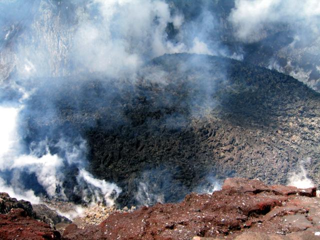 |
Figure 15. Reventador's 2004 lava flow/dome as seen on 28 November 2004. The photo was taken looking W and downward from the cone's eastern crater rim (see vantage point indicated by the star on figure 11). Courtesy of IG. |
IG observers estimated that the total mid-December lava flow volume was ~ 3 x 10⁶ m3. The inferred 22 November date of flow onset would imply a steady-state extrusion rate of ~ 0.1 x 10⁶ m3 per day and a flow front advancing at ~ 80 m per day. These observations appear to conform with satellite thermal infrared observations, which noted no significant anomalies until the end of November, due presumably in large part to the lava being confined within the steep-walled crater. Inclement weather occurred and also may have impeded some of the satellite thermal observations.
The most recent visit to the crater rim, on 11 December 2004, traced the source of degassing and lava outflow to the most elevated portion of a small dome-like feature at the central western margin of the crater. Figure 16 shows how instrumentally aided nighttime incandescence observations disclosed both the vent area and surficial flow-textures extending S towards the southern breach of the cone. Figure 14 also documents a comparatively narrow arm of lava trending towards the cone's northern breach. Nighttime incandescence from the lava flow was also visible from local communities such as El Chaco, ~ 20 km distant.
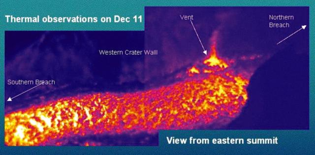 |
Figure 16. Thermal image of the lava flow in the interior of Reventador crater taken with a Forward Looking Infrared (FLIR) imager at 2000 on 11 December 2004. Courtesy of IG. |
Figure 17 illustrates the scene on 12 December 2004 during a visit to the front of the most advanced lobe of lava (for location, see star at end of flow lobe, figure 9). IG-EPN staff estimated the flow front at ~ 20 m high and saw incandescent blocks falling off of it.
|
Figure 17. A N-looking view of Reventador's gray-colored lava-flow front taken on 12 December 2004 at ~ 2,600 m elevation. Person at right indicates scale of the advancing flow front. The lava flow emanated from the breach in the S side of the cone's crater, a spot seen in the photo's upper left. Courtesy of IG. |
Geological Summary. Volcán El Reventador is the most frequently active of a chain of Ecuadorian volcanoes in the Cordillera Real, well east of the principal volcanic axis. The forested, dominantly andesitic stratovolcano has 4-km-wide avalanche scarp open to the E formed by edifice collapse. A young, unvegetated, cone rises from the amphitheater floor to a height comparable to the rim. It has been the source of numerous lava flows as well as explosive eruptions visible from Quito, about 90 km ESE. Frequent lahars in this region of heavy rainfall have left extensive deposits on the scarp slope. The largest recorded eruption took place in 2002, producing a 17-km-high eruption column, pyroclastic flows that traveled up to 8 km, and lava flows from summit and flank vents.
Information Contacts: Patricio Ramón, Daniel Andrade, David Rivero, Alexandra Alvarado, Sandro Vaca, and Pete Hall, Geophysical Institute (IG), Escuela Politécnica Nacional, Apartado 17-01-2759, Quito, Ecuador (URL: http://www.igepn.edu.ec/); Jeffrey B. Johnson, Dept. of Earth Sciences, James Hall University of New Hampshire, Durham, NH 03824; MODIS Thermal Alert System, Hawaii Institute of Geophysics and Planetology (HIGP), School of Ocean and Earth Science and Technology, University of Hawaii at Manoa (URL: http://modis.higp.hawaii.edu/).