Report on Sierra Negra (Ecuador) — September 2005
Bulletin of the Global Volcanism Network, vol. 30, no. 9 (September 2005)
Managing Editor: Richard Wunderman.
Sierra Negra (Ecuador) Caldera erupts starting 22 October 2005 at fissure on caldera's inner N wall
Please cite this report as:
Global Volcanism Program, 2005. Report on Sierra Negra (Ecuador) (Wunderman, R., ed.). Bulletin of the Global Volcanism Network, 30:9. Smithsonian Institution. https://doi.org/10.5479/si.GVP.BGVN200509-353050
Sierra Negra
Ecuador
0.83°S, 91.17°W; summit elev. 1124 m
All times are local (unless otherwise noted)
At about 1730 on 22 October 2005 Sierra Negra began erupting. This shield volcano with a large oval-shaped caldera is located at the S end of Isabela Island. Circumferential fractures define the northern edge of the caldera. Volcán Chico, noted for its 1963 and 1979 eruptions, is comprised of a series of scoria cones and other vents aligned along several prominent fractures on the outer slope of the N caldera rim. The present activity is not related to the Volcán Chico fracture system, but is venting from fractures along the N inner caldera wall. The most prominent fracture can be traced westward ~3 km where it lies along the rim. This initial report was provided by a scientific team from the Instituto Geofísico.
The eruption was preceded by a seismic event at 1438 on 22 October, felt in the coastal village of Villamil (20 km SE of the caldera border) and by Park Wardens on Cerro Azul. Others reported single earthquakes on 19 October and two weeks earlier. At 1730 the eruption began with an explosion heard by many people in the Villamil area. Hikers in the area of the subsequent lava emission in the mid-afternoon of both 21 and 22 October witnessed no unusual activity. By 1745 the eruption column had reached an estimated altitude of 5 km, and the setting sun illuminated the light gray eruption column. At 1815 the team observed the column after sunset from Point (Punto) Ayora, Santa Cruz Island (80 km E) and estimated its height at 10 km. The still-rising column was 4-6 km wide, not spreading laterally, and a small lenticular cloud was beginning to form a cap over the column. As night fell, the western sky above the caldera was a burgundy red, suggesting that lava had covered an extensive area of the caldera floor. Satellite imagery of the eruption at 1745 showed an eruption cloud at an estimated altitude of at least 15 km moving SW. A very large hotspot in the multispectral imagery was also observed and continued on 27 October.
Observations at 1945 from the Santa Cruz highlands (75 km away) employing a camcorder with night vision capabilities confirmed extensive lava fountaining estimated to be 200-300 m high along a segment of the caldera rim, as well as the incandescence from a lava flow several kilometers long descending the NW outer flank. Although the complete eruption column was not visible, it may have reached an altitude close to 20 km and had spread out. Tourist boats between Isabela and Fernandina Island reported seeing two lava flows descending the N flank.
During an overflight between 0715 and 0900 on 23 October the team did not witness active lava flows or evidence of lava having entered the sea. A thin khaki-colored ash cloud layer was observed, between about 1,200 and 1,500 m altitude, that had spread out laterally and extended E as far as St. Cruz Island and N to Santiago Island. Later in the day the plume was directed NNW in agreement with satellite information. From the plane the team confirmed that the main eruption was venting from four craters along a 500-m-long fracture at the base of the NNE inner caldera wall. The highest lava fountaining (up to 200 m high) was being generated at the two middle vents, while the end vents were feeding many lava flows S onto the caldera floor. The fracture apparently extended W along the inner wall, but then climbed to the caldera rim where its trace was not obvious. However, small vents with fountaining and incandescent lava were observed on the rim along this general fracture system, implying that the active fracture extended ~ 2 km W of the main vents.
During the mid-day hours of 23 October the team ascended the S flank, followed the E rim of the caldera, and reached a point ~ 800 m from the active vents, from which the following description was made. From the four principal vents the lava flowed S with exceptional force, volume, and speed downslope in three main channels (figures 3 and 4). Based on the apparent speed of the lava, and the more than 10-m height of the waves in the stream of passing lava, the team estimated that the main lava flow was traveling nearly 20 m/second as it left its vent. The W channels, some 30-50 m wide, maintained their red incandescent color and high speeds, albeit less than that near the vent.
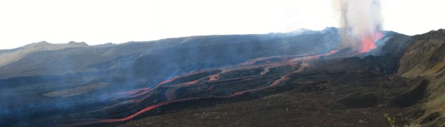 |
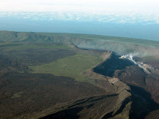
Figure 3. View looking W from the NE rim of Sierra Negra's caldera (right) on 23 October 2005. The caldera floor is to the left. The four active vents are superimposed in this photo, aligned along the E-W fracture that lies at the base of the inner caldera wall. Numerous lava flows descended southwards to the left where they joined to form one single flow of a'a lava ~ 1 km wide and 7 km long that had already reached the southern inner wall of the caldera on 23 October. Courtesy of M. Hall. |
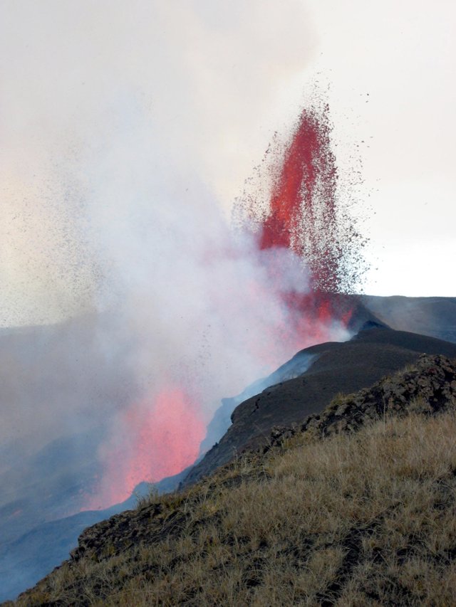 |
Figure 4. A 150-m-high lava fountain rises on 23 October 2005 from one of four active vents that define the active fracture system at the base of the northern inner wall of Sierra Negra's caldera. From these four principal vents lava flows moved southwards at velocities estimated at close to 20 m/second on 23 October. Courtesy of M. Hall. |
By 1500 the E channel was slowing and cooling to a gray surface color; this thin solid veneer was subsequently fragmented when the flow went over the edge of the bench and cascaded to the caldera floor. On the caldera floor the incandescent lavas of all three channels disappeared under the black solidified a'a lava that already covered about 12% of the caldera. In the 22 hours since the eruption had begun, the lavas had formed one large flow 1-1.5 km wide that traveled SE along the base of the E interior caldera wall, then W along the S wall reaching a point almost halfway across the caldera. As such it had traveled a total distance of 7 km and had started small brush fires on the floor and interior walls of the caldera. With an estimated thickness of no more than 3 m, the volume of the lava ejected by 1530 on 23 October was calculated at about 25 million cubic meters.
Along the trail leading to the vent area an increasing amount of scoria fragments was observed on the rim's edge. Fragments ~ 1 cm in size were first observed ~ 4 km SE of the active vents, and they increased in size (up to 15 cm) and abundance towards the vents. Very little fine ash was in the air or on the ground along the E caldera rim. The scoria was black, exceedingly vesiculated, with vesicles from millimeter to many centimeters in diameter; it seemed comparable in density to popcorn. No crystals were observed in the glassy scoria material. At their closest approach to the vent, scoria fragments formed a deposit 3-5 cm thick.
An explosion heard at 1900 on 25 October was accompanied by a dark eruptive column and minor ashfall along the E rim of the caldera and probably elsewhere. By early 26 October the Park Wardens were reporting that one of the four principal vents had shut down. Observations made late on 26 October indicated that the a'a flow on the caldera floor had slowed and was still several kilometers from the sulfur mine area. Civil Defense officials also reported that apparently less lava was leaving the vents and that lava extrusion might have shifted to the outer N flank, possibly to the Volcán Chico fracture system.
The only inhabited areas include the small town of Villamil, located 20 km SE of the caldera's border on the S coast, plus several other small populated areas about halfway between the caldera and Villamil. There was no immediate threat to those residents, given the fact that in order to spill out of the caldera and descend the S flanks the entire 100-m depth of the caldera would have to fill with lava. The southern caldera border has not been active in the recent geologic past.
Geological Summary. The broad shield volcano of Sierra Negra at the southern end of Isabela Island contains a shallow 7 x 10.5 km caldera that is the largest in the Galápagos Islands. Flank vents abound, including cinder cones and spatter cones concentrated along an ENE-trending rift system and tuff cones along the coast and forming offshore islands. Although it is the largest of the five major Isabela volcanoes, it has the flattest slopes, averaging less than 5° and diminishing to 2° near the coast. A sinuous 14-km-long, N-S-trending ridge occupies the west part of the caldera floor, which lies only about 100 m below its rim. The Volcán de Azufre fumarolic area lies within a graben between this ridge and the west caldera wall. Lava flows from a major eruption in 1979 extend all the way to the north coast from circumferential fissure vents on the upper northern flank.
Information Contacts: Minard Hall and Patricio Ramón, Instituto Geofísico, Escuela Politécnica Nacional, Apartado 17-01-2759, Quito, Ecuador (URL: http://www.igepn.edu.ec/); Washington Tapia and Oscar Caravajal, Parque Nacional Galápagos, Pto. Ayora, Santa Cruz Island, Ecuador.