Report on Manam (Papua New Guinea) — April 2008
Bulletin of the Global Volcanism Network, vol. 33, no. 4 (April 2008)
Managing Editor: Richard Wunderman.
Manam (Papua New Guinea) Low-level eruptions continue in late 2007 and early 2008
Please cite this report as:
Global Volcanism Program, 2008. Report on Manam (Papua New Guinea) (Wunderman, R., ed.). Bulletin of the Global Volcanism Network, 33:4. Smithsonian Institution. https://doi.org/10.5479/si.GVP.BGVN200804-251020
Manam
Papua New Guinea
4.08°S, 145.037°E; summit elev. 1807 m
All times are local (unless otherwise noted)
Low-level seismicity and mild eruptions occurred from mid-May 2007 through mid-September 2007 (BGVN 32:08). This report addresses activity between the end of September 2007 through mid-May 2008, with gaps in reporting as noted. For the most part, Manam remained at a low eruptive level, but four fatalities from the early 2007 activity were noted in news reports.
According to the Rabaul Volcano Observatory (RVO), ash plumes were occasionally emitted both during the first half of October 2007, during 5-8 November 2007, and on 27 December 2007. The Darwin Volcanic Ash Advisory Centre (VAAC) noted that one plume rose to 3.7 km during 3-9 October and another rose to 3 km on 27 December. White vapor plumes were also emitted occasionally during October and November, and incandescence was reported on 29 September, 1 October, 10-11 October, 30 October, and 4-5 November. Roaring noises were heard on 30 October.
Manam remained quiet during January and February 2008. Both the Main Crater and South Crater continued to release thin to thick white vapor. At Main Crater, a weak red glow was visible at night on 10 January, and a fluctuating red glow was visible from the Main Crater during 8-11 February and 22-25 February. Seismic activity was at the low-to-moderate level through 14 January, when lightning struck the monitoring equipment. The number of daily low-frequency volcanic earthquakes up through the lightning strike ranged between 500 and 970. The equipment was fixed on 28 February. On 29 February, 770 low frequency earthquakes were recorded. On 9-10 February, pale gray ash clouds were emitted from the Main Crater.
RVO reports covering the interval March and April 2008 were unavailable at the time of this writing. RVO reported Manam as quiet during May 2008, emitting only variable amounts of white vapor. Glow was reported from Main Crater on the nights of 16-20 May.
Editors searched MODVOLC thermal alerts on 10 June 2008 and found that they occurred on six days during the interval April-July 2007. After previously mentioned alerts on 16 and 23 May 2007 (UTC)(BGVN 32:08), the only subsequent alerts occurred on 8 June and 26 July 2007 (UTC).
The Darwin VAAC reported plumes to altitudes of several kilometers from Manam on 2 April, 14-15 April (ash-and-steam), 23-29 April, and 11-12 May 2008. The plumes during 11-12 May rose to an altitude of 3 km and extended ~ 36 km laterally.
Fatalities and injury. To supplement our previous report (BGVN 32:08), we note that an article by Reuters on 20 March 2007 reported that during the past week a mudslide on Manam killed four people in "an avalanche of ash and mud," and that a fifth person was seriously injured. RVO noted that they received word of the event on the 15th, suggesting the event was probably on 14 or 15 March. It occurred in a valley on the island's N side.
The news account quoted Health Minister Sir Peter Barter as saying, "The valleys are very dangerous and I am appealing to everyone not to venture into any of the valleys as there are huge quantities of ash and mud deposited on higher slopes. After heavy rain that has been experienced, the mud and loose material becomes a major risk for anyone venturing into the potential path of an avalanche."
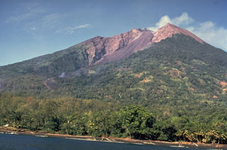
Geological Summary. The 10-km-wide island of Manam, lying 13 km off the northern coast of mainland Papua New Guinea, is one of the country's most active volcanoes. Four large radial valleys extend from the unvegetated summit of the conical basaltic-andesitic stratovolcano to its lower flanks. These valleys channel lava flows and pyroclastic avalanches that have sometimes reached the coast. Five small satellitic centers are located near the island's shoreline on the northern, southern, and western sides. Two summit craters are present; both are active, although most observed eruptions have originated from the southern crater, concentrating eruptive products during much of the past century into the SE valley. Frequent eruptions, typically of mild-to-moderate scale, have been recorded since 1616. Occasional larger eruptions have produced pyroclastic flows and lava flows that reached flat-lying coastal areas and entered the sea, sometimes impacting populated areas.
Information Contacts: Herman Patia and Steve Saunders, Rabaul Volcano Observatory (RVO), P.O. Box 386, Rabaul, Papua New Guinea; Darwin Volcanic Ash Advisory Centre (VAAC), Bureau of Meteorology, Northern Territory Regional Office, PO Box 40050, Casuarina, Northern Territory 0811, Australia (URL: http://www.bom.gov.au/info/vaac/).

