Report on Nyiragongo (DR Congo) — December 2012

Bulletin of the Global Volcanism Network, vol. 37, no. 12 (December 2012)
Managing Editor: Richard Wunderman.
Edited by Jen Fela.
Nyiragongo (DR Congo) Bubbling lava lake visited by three groups during January 2011
Please cite this report as:
Global Volcanism Program, 2012. Report on Nyiragongo (DR Congo) (Fela, J., and Wunderman, R., eds.). Bulletin of the Global Volcanism Network, 37:12. Smithsonian Institution. https://doi.org/10.5479/si.GVP.BGVN201212-223030
Nyiragongo
DR Congo
1.52°S, 29.25°E; summit elev. 3470 m
All times are local (unless otherwise noted)
This report discusses observations of Nyiragongo made in January 2011. As noted in BGVN 35:09, a 14-24 June 2010 expedition into the crater showed that Nyiragongo's lava lake was continuously active and had risen since the last extensive eruption that inundated central Goma in January 2002.
Similar activity was confirmed during visits by three groups to the crater during 9-12 January, 16-26 January, and 20-23 January 2011, with observations of a continuously active lava lake, lava fountains reaching several meters high, and gas emissions (figures 48 and 49; dozens more images appear on the websites noted in the Information Contacts subsection). One group described the lava lake as "boiling so lively and quick-tempered, like cream of wheat in a pot at the highest heat setting."
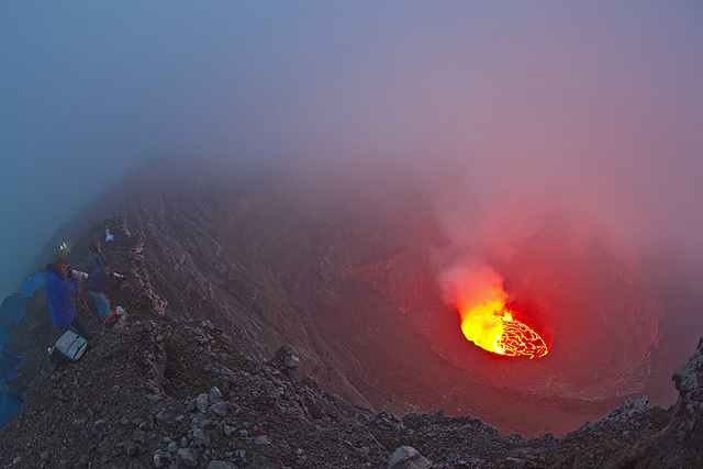 |
Figure 48. Photographers watched Nyiragongo's lava lake from an undisclosed point on the rim; this photo was taken in low-light conditions sometime during 9-12 January 2011. Disrupted portions of the lava lake surface (described by observers as "degassing fountains") often formed clusters that shifted position as the lava lake underwent convection. Fumes emitted through the disruptions rose vertically and were illuminated by the intense glow of the lava. Courtesy of Tom Pfeiffer (Volcano Discovery). |
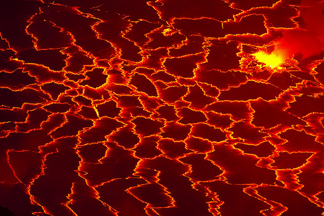 |
Figure 49. A photo taken at night sometime during 9-12 January 2011 showing an isolated disruption in the crust of Nyiragongo's lava lake (a surface composed of numerous interlocking polygonal plates) and spatter. The plates were drawn towards the disruption, rather than pushed away. The lake's cooling crust was thin and easily torn apart, exposing hot lava, which in turn quickly cooled to form new plates. Photo courtesy of Tom Pfeiffer (Volcano Discovery). |
On 20 January 2011, the topography of the interior of the crater remained the same as in mid-June 2010 (figure 50). The surface of the lava lake was then between 3,010 m and 3,020 m elevation. Convection of the lava lake surface and disruptions in the cooled surface that produced fountains and gas emissions were observed at differing intensities. The symbols in figure 50 correspond to those of figure 45 in our previous report, thus preserving terminology (BGVN 35:09). The observers recognized three upper terraces from the previous figure (α, β, and γ) but not all are visible in figure 50.
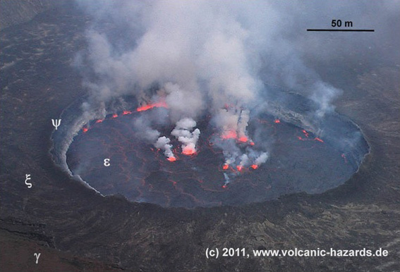 |
Figure 50. Image of the lava lake inside the crater of Nyiragongo on 20 January 2011. The central crater contains the lava lake (ε), which oscillated. A ring wall (ψ) confined the lake and led to the lower terrace (ξ). The rim of the ring wall is several meters higher than the lower terrace. The photo is taken at some elevation above the post 1977-2002 eruption terrace (γ). The team noted variations in both the lake's convection and degassing fountains. Courtesy of Christoph Weber. |
Geological Summary. The Nyiragongo stratovolcano contained a lava lake in its deep summit crater that was active for half a century before draining catastrophically through its outer flanks in 1977. The steep slopes contrast to the low profile of its neighboring shield volcano, Nyamuragira. Benches in the steep-walled, 1.2-km-wide summit crater mark levels of former lava lakes, which have been observed since the late-19th century. Two older stratovolcanoes, Baruta and Shaheru, are partially overlapped by Nyiragongo on the north and south. About 100 cones are located primarily along radial fissures south of Shaheru, east of the summit, and along a NE-SW zone extending as far as Lake Kivu. Many cones are buried by voluminous lava flows that extend long distances down the flanks, which is characterized by the eruption of foiditic rocks. The extremely fluid 1977 lava flows caused many fatalities, as did lava flows that inundated portions of the major city of Goma in January 2002.
Information Contacts: Tom Pfeiffer, Volcano Discovery (URL: http://www.volcanodiscovery.com/); Marc Szeglat, Vulkane.net (URL: http://vulkane.net/); Christoph Weber, VHDL, Muehlweg 11, 74199 Untergruppenbach, Germany (URL: http://www.volcanic-hazards.de/).