Report on Reventador (Ecuador) — June 2017

Bulletin of the Global Volcanism Network, vol. 42, no. 6 (June 2017)
Managing Editor: Edward Venzke.
Edited by A. Elizabeth Crafford.
Reventador (Ecuador) Lava flows, pyroclastic flows, and ash plumes monthly during June 2014-December 2015
Please cite this report as:
Global Volcanism Program, 2017. Report on Reventador (Ecuador) (Crafford, A.E., and Venzke, E., eds.). Bulletin of the Global Volcanism Network, 42:6. Smithsonian Institution. https://doi.org/10.5479/si.GVP.BGVN201706-352010
Reventador
Ecuador
0.077°S, 77.656°W; summit elev. 3562 m
All times are local (unless otherwise noted)
The andesitic Volcán El Reventador lies well east of the main volcanic axis of the Cordillera Real in Ecuador and has historical observations of eruptions of numerous lava flows and explosive events going back to the 16th century. The largest historical eruption took place in November 2002 and generated a 17-km-high eruption cloud, pyroclastic flows that traveled 8 km, and several lava flows. This report briefly summarizes activity between 2002 and June 2014, and covers details of activity from July 2014 through December 2015. The volcano is monitored by the Instituto Geofisico-Escuela Politecnicia Nacional (IG) of Ecuador, and the Washington Volcanic Ash Advisory Center (VAAC).
Summary of 2002-2014 activity. Intermittent activity including pyroclastic flows, ash plumes, lava flows and explosive events took place between 2003 and 2008. Since July 2008 there have been persistent gas-and-ash plumes, dome growth, and both pyroclastic and lava flows. Lahars are also very common in this high-rainfall area, and cause damage to infrastructure on a regular basis. A lava dome was first observed growing in September 2009 within the crater that formed during the 2002 eruption. By July 2011, it had reached the height of the highest part of the crater rim; by January 2013 it filled the crater and formed a new summit, 100 m above the E rim. This led to lava blocks travelling down the flanks, in addition to the lava flows and pyroclastic flows traveling down the flanks of the cone inside the crater during 2012-2014. A summary of thermal anomalies compiled from MIROVA data (figure 46) demonstrates the ongoing but intermittent nature of heat flow between 2002 and 2014.
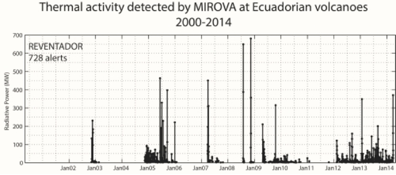 |
Figure 46. Thermal activity detected by the MIROVA system at Reventador, January 2002-January 2014. Courtesy of IG (Informe Especial del Volcan Reventador No. 3, 7 July 2014). |
Summary of June 2014-December 2015 activity. Activity was very consistent throughout the period of June 2014 through December 2015. The thermal webcam captured images of lava flows, pyroclastic flows and ejected incandescent blocks nearly every month. MODVOLC thermal alerts were reported every month except March 2015. Satellite imagery of hot spots were common as well. The Washington VAAC reported observations of ash plumes every month, although they generally rose only to altitudes below 5.6 km (2 km above the summit). IG reported seismicity as varying between moderate and high during the period.
Activity during June-December 2014. Activity during June 2014 was characterized by numerous explosions and small pyroclastic flows that descended the flanks of the cone. The Washington VAAC issued two series of reports on 11-12 and 19-20 June. A pilot reported an ash plume on 11 June rising 2.8 km above summit at 6.4 km altitude and drifting W, and the next day ash was observed 1.8 km above the summit. Weather generally obscured satellite views. On 19 June, multiple small emissions of volcanic ash were seen in the observatory webcam along with incandescent material on the flanks. MODVOLC thermal alerts were issued on 5, 21, and 30 June.
IG reported a new lava flow on 2 July 2014 descending 400 m on the SSW flank. A pyroclastic flow was also reported on 2 July (figure 45, BGVN 39:07) extending 1,500 m down the S flank. IG noted ash emissions on 2, 4, 9-12, 18, 22-24, and 27 July rising 800 m to 2 km above the summit. MODVOLC reported multi-pixel thermal alerts on 2, 16, and 27 July, and single pixel alerts on 10 and 25 July. In addition to the ash plumes reported by IG, the Washington VAAC reported on-going ash emissions and detected hotspots at the crater on 31 July.
The Washington VAAC issued a report of hot spots visible in satellite imagery on 1 August 2014 and a pilot report of an ash plume at 6.1 km altitude (2.5 km above the summit) on 25 August. The only MODVOLC thermal alerts were issued on 31 August. IG reported lower level plumes (300-800 m above the summit) with minor ash on 6 other days during the month.
Activity increased during September 2014. The Washington VAAC issued reports during 2-4, 18, and 23 September. On 2 September, ash plumes were observed extending about 45 km W of the summit at 5.5 km altitude. Another faint plume of volcanic ash was observed within 20 km of the summit the next day. An ongoing hotspot with possible small ash emissions was noted on 4 September. IG reported an explosion on the morning of 5 September that generated a plume and ejected blocks from the crater that fell ~500 m below the summit on the W flank. A thermal camera detected an explosion on the following day that also included ballistics. MODVOLC thermal alerts were issued on eight days during September. Steam plumes with minor ash rose to around 1 km above the summit and dispersed generally W several times during the month.
A single MODVOLC thermal alert was reported on 6 October 2014. The Washington VAAC reported short 2-3 minute bursts of minor volcanic ash on 19 October which was seen drifting WNW and dispersing within 16 km of the summit below 5.8 km altitude. An additional single pixel thermal alert was issued on 25 October, and a three-pixel alert appeared on 29 October.
IG reported steam-and-ash plumes rising up to 1 km above the summit a few times during the month, which were visible on the rare clear-weather days (figure 47). Only two days in November, 5 and 21, had MODVOLC thermal alerts. The Washington VAAC, however, issued reports during 11-12, 18-19, and 27 November of possible low-level ash-bearing plumes. The IG webcam LAVA on the SE flank captured images of pyroclastic flows on 20 and 25 November (figure 48).
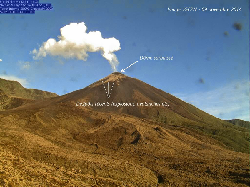 |
Figure 47. The active cone at Reventador on 9 November 2014 with a low-level steam plume. Image taken from the IG Webcam LAVA on the SE flank. Courtesy of IG via La Culture Volcan. |
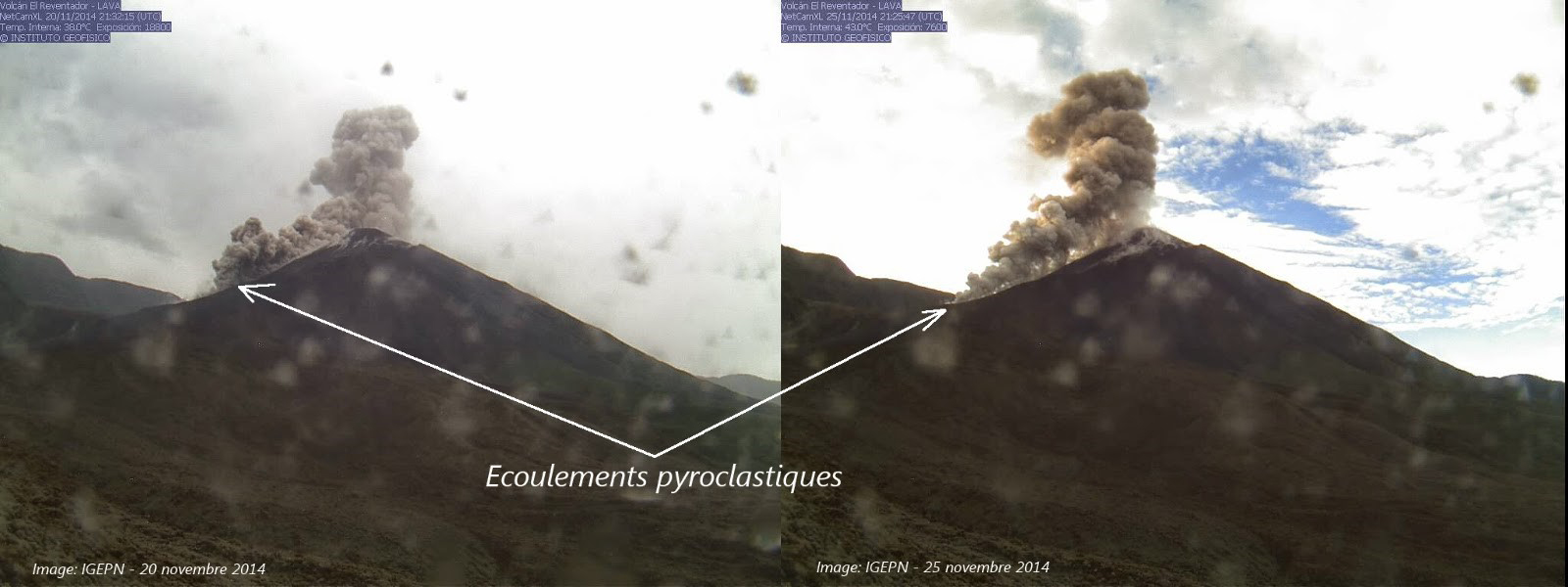 |
Figure 48. Pyroclastic flows at Reventador, 20 (left) and 25 (right) November 2014 taken from the IG LAVA webcam on the SE flank. Courtesy of IG via Culture Volcan. |
On 5 December 2014 a webcam recorded a steam-and-gas emission associated with an incandescent lava flow on the E flank. MODVOLC thermal alert pixels appeared on four days in December 2014 (3, 7, 14, and 23), and VAAC reports of ash plumes were issued on 5, 13-14, 21-22, and 30 December. The largest plume, on 14 December, rose to 6.1 km (2.5 km above the summit) and drifted NE. IG reported moderate seismicity and low-level steam plumes with minor ash content on several occasions.
Activity during 2015. Moderate seismic activity continued during January 2015 with low-level steam-and-ash plumes from explosions rising a few hundred meters above the summit, according to IG. A larger explosion reported by IG on 16 January generated an ash plume that rose 2 km and drifted SE. The Washington VAAC reported activity from 14-18 January, and again on 26 January. Their reports were of small puffs of ash within a kilometer of the summit drifting for a few hours before dissipating. MODVOLC thermal alerts were issued on 15 and 29 January.
Steam plumes containing minor amounts of ash were recorded a few times during February 2015 during periods of moderate seismicity. The Washington VAAC issued several reports, during 7-9, 13-17, 19-21, 24, and 26-28 February, noting occasional plumes with ash rising to less than one km above the summit, and hot-spots seen in satellite imagery on 13-14, 17, 19, and 27 February. An aircraft reported volcanic ash on 19 February at 6.1 km altitude. A new lava flow first observed on the SW flank on 11 February had advanced 1 km by 19 February. This is consistent with the four-pixel MODVOLC thermal alert issued on 18 February. Single pixel alerts were issued on 7, 19, and 23 February as well.
No MODVOLC thermal alerts were issued during March 2015, but the Washington VAAC continued to note low-level small bursts of ash emissions several times a week within 15 km of the summit, as reported by IG. The webcam captured a hotspot at the summit on 11 March. A thermal camera image of a lava flow taken on 13 March showed the visible part of it to be over 500 m long (figure 49), and IG noted in their 13 March report that is was actually about 1.5 km long that day.
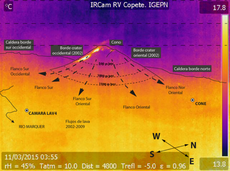 |
Figure 49. Annotated thermal camera image at Reventador of an 11 March 2015 lava flow. Camera is located SE of the volcano. Courtesy of IG (Informe especial del Volcan Reventador No. 1, 13 March 2015). |
Activity during April 2015 included moderate seismicity and incandescence at the crater reported by IG. A lava flow on the SW flank was visible with the infrared camera during the first week; this agrees with the 5-pixel MODVOLC thermal alert recorded on 5 April and the bright hotspot observed in both satellite imagery and the webcam during 3-5 April. Hot spots were observed via satellite and webcam several additional times during the month. Additional thermal alerts also appeared on 10 and 21 April. Steam-and-ash plumes rising to 1 km above the summit were intermittent throughout the month, mostly observed from the webcam.
Multi-pixel MODVOLC thermal alerts appeared during 2-3, 20, and 30 May, indicating continued sources of heat from lava flows. In a special report issued on 19 May, IG noted a new lava flow during the previous week that descended the S flank, forming a fan with three lobes on the SE and SW flanks. The length was greater than 1,000 m from the summit on 19 May, although the flows remained on the flanks of the summit cone within the caldera (figure 50). IG noted an increase in emission tremor on 17 May which may have been related to the extrusion of the lava, but weather conditions prevented visual confirmation. During 17-30 May, intermittent low-level gas-and-ash plumes within 15 km of the summit were reported on most days.
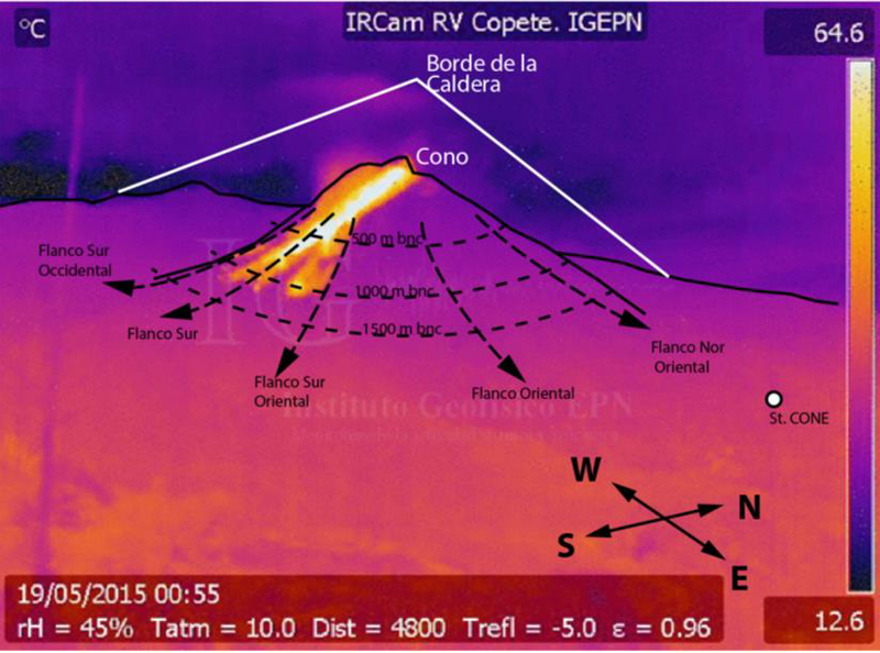 |
Figure 50. Annotated thermal image of the summit cone of Reventador on 19 May 2015 showing a 3-lobed lava flow descending the S flank of the cone for more than 1 km. Courtesy of IG (Informe especial del Volcan Reventador No. 2, 19 May 2015). |
MODVOLC thermal alerts diminished during June 2015, occurring only on 8 and 15 June. Nonetheless, thermal images showed lava flows down the SW and S flanks of the cone several times, and hot spots were observed in satellite images and on the webcam when the weather permitted. Steam-and-ash plumes were generally reported to rise to 1 km or less above the summit and drift usually NW or SW within 15 km of the volcano. A pilot reported volcanic ash on 30 June at 6.7 km, but no ash was seen in satellite imagery under cloudy conditions. IG issued a special report on 24 June noting increased seismicity in the form of increased tremor signal and explosions on 23 June. The thermal camera located in the area of El Copete, 5 km S of the crater, showed an increase in surface activity characterized by several lava flows on the SW, S, and SE flanks exceeding one km in length (figure 51).
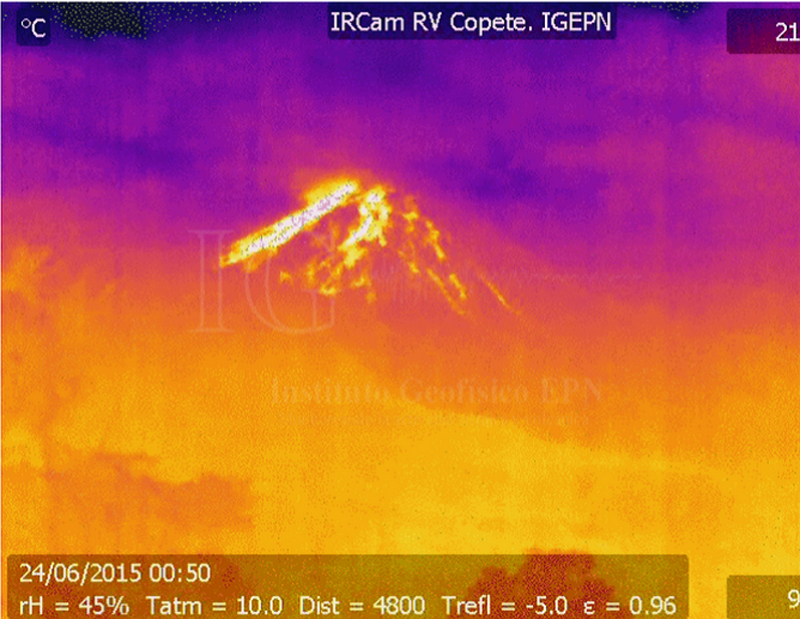 |
Figure 51. Thermal image of Reventador taken on 23 June at 1950 by the webcam near El Copete. Courtesy of IG (Informe especial del Volcan Reventador No. 3, 24 June 2015). |
Seismic activity was reported as high during July 2015 by IG, and included explosions, tremor, long-period earthquakes, harmonic tremor, and emission signals. During the first week, incandescent material was visible more than 1 km down the SE flank in thermal images. On 17 July, light gray deposits possibly from a pyroclastic flow were observed; on 21 July explosions again ejected incandescent material onto the flanks. Steam and ash emissions were intermittent and generally remained below 5.1 km altitude. MODVOLC thermal alerts appeared on 1, 3, 15, and 17 July.
High levels of seismic activity continued during August 2015. The Washington VAAC reported possible ash plumes on 14 days during the month, and MODVOLC thermal alerts were issued on six dates, including four-pixel alerts on 4 and 27 August suggestive of lava flows and/or incandescent material on the flanks of the cone. A discrete volcanic ash emission on 6 August was reported by the Washington VAAC at 7 km altitude (3.4 km above the summit) with a plume extending about 25 km NW of the summit. Other plumes that were reported by pilots (on 25 August at 8.8 km altitude moving NW, and on 26 August at 6.7 km moving W) were not observed in cloudy satellite imagery.
Ash-and-gas emissions were reported by the Washington VAAC during 14 days in September 2015, generally drifting N and W at altitudes less than 2 km above the crater (5.6 km altitude); high levels of seismicity also continued, according to IG. The Guayaquil MWO reported volcanic ash at 6.1 km on 19 September. Puffs of ash seen in the webcam were reported at 7.3 km altitude on 25 September and thought to have quickly dissipated. MODVOLC thermal alerts appeared on seven days during the month; five of them were two- or three-pixel alerts. An SO2 plume drifting WNW from Reventador was captured by NASA's OMI instrument on 22 September (figure 52).
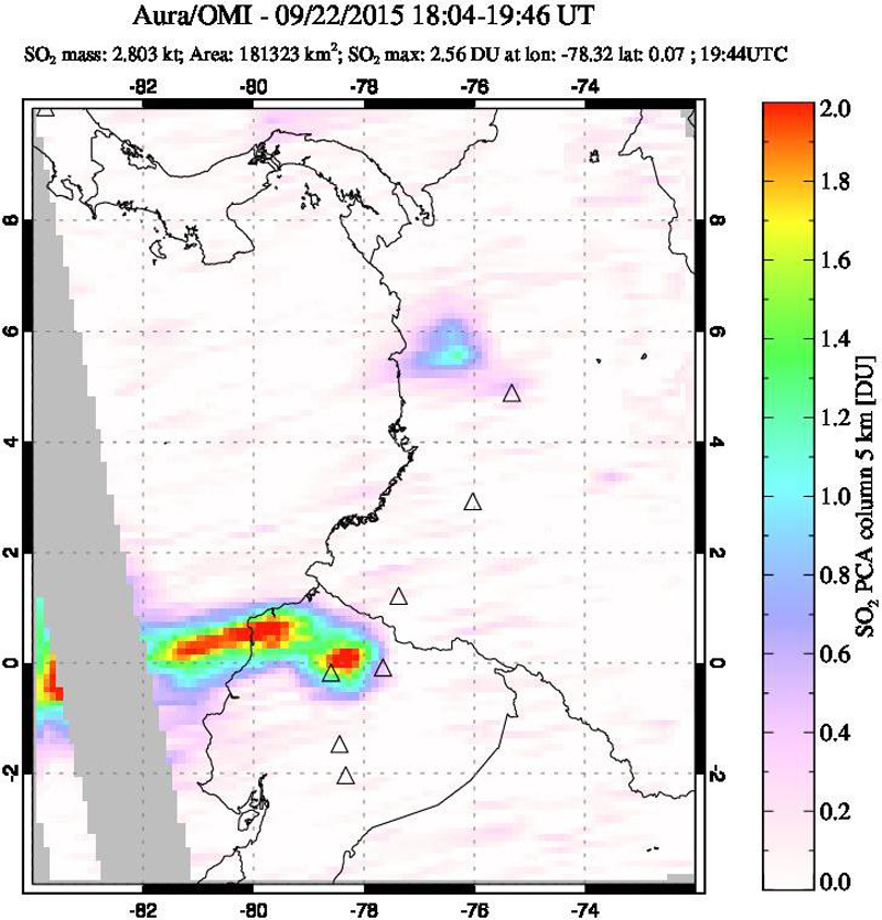 |
Figure 52. An SO2 plume drifting W from Reventador on 22 September 2015. Reventador is represented by the triangle south of the NW-SE trending Ecuador/Colombia border in the bottom center of the image near longitude 78 W just south of the equator. A small plume in the top half of the image is likely SO2 from Nevado del Ruiz. Courtesy of NASA/GSFC. |
A series of VAAC reports of low-level minor ash emissions were issued during 1-5 October 2015. After two weeks of no activity, multi-pixel MODVOLC thermal alerts and VAAC reports increased during 20-30 October. The peak MODVOLC activity included 4-6 daily pixels during 26-28 October, and the VAAC reports noted a bright hotspot on the satellite images beginning on 20 October and present for most of the rest of the month. Continuous emissions were observed in the webcam during 22-26 October, generally below 4.6 km, moving NW, and extending up to 40 km from the summit. Continuous emissions appeared again on 30 October at 5.1 km moving W.
During the last two weeks of November 2015, steam, gas, and ash emissions rose to less than 2 km above the summit and incandescent blocks rolled 500 m down the flanks of the cone. MODVOLC thermal alerts were reported for five days between 15 and 29 November. Similar activity was reported during December, although the Washington VAAC only issued reports on four different days, and MODVOLC thermal alerts were recorded only on 6 and 24 December. VAAC reports noted hotspots in satellite imagery on 7 December. The VAAC reports on 11 and 16 December indicated ash plumes at 5.5 km moving W and SW.
Geological Summary. Volcán El Reventador is the most frequently active of a chain of Ecuadorian volcanoes in the Cordillera Real, well east of the principal volcanic axis. The forested, dominantly andesitic stratovolcano has 4-km-wide avalanche scarp open to the E formed by edifice collapse. A young, unvegetated, cone rises from the amphitheater floor to a height comparable to the rim. It has been the source of numerous lava flows as well as explosive eruptions visible from Quito, about 90 km ESE. Frequent lahars in this region of heavy rainfall have left extensive deposits on the scarp slope. The largest recorded eruption took place in 2002, producing a 17-km-high eruption column, pyroclastic flows that traveled up to 8 km, and lava flows from summit and flank vents.
Information Contacts: Instituto Geofísico (IG), Escuela Politécnica Nacional, Casilla 17-01-2759, Quito, Ecuador (URL: http://www.igepn.edu.ec/); Washington Volcanic Ash Advisory Center (VAAC), Satellite Analysis Branch (SAB), NOAA/NESDIS OSPO, NOAA Science Center Room 401, 5200 Auth Rd, Camp Springs, MD 20746, USA (URL: http://www.ospo.noaa.gov/Products/atmosphere/vaac/, archive at: http://www.ssd.noaa.gov/VAAC/archive.html); MIROVA (Middle InfraRed Observation of Volcanic Activity), a collaborative project between the Universities of Turin and Florence (Italy) supported by the Centre for Volcanic Risk of the Italian Civil Protection Department (URL: http://www.mirovaweb.it/); Hawai'i Institute of Geophysics and Planetology (HIGP), MODVOLC Thermal Alerts System, School of Ocean and Earth Science and Technology (SOEST), Univ. of Hawai'i, 2525 Correa Road, Honolulu, HI 96822, USA (URL: http://modis.higp.hawaii.edu/); NASA Goddard Space Flight Center (NASA/GSFC), Global Sulfur Dioxide Monitoring Page, Atmospheric Chemistry and Dynamics Laboratory, 8800 Greenbelt Road, Goddard, Maryland, USA (URL: https://so2.gsfc.nasa.gov/); Culture Volcan, Journal d'un volcanophile (URL: https://laculturevolcan.blogspot.fr/).