Report on Sinabung (Indonesia) — December 2017

Bulletin of the Global Volcanism Network, vol. 42, no. 12 (December 2017)
Managing Editor: Edward Venzke.
Edited by A. Elizabeth Crafford.
Sinabung (Indonesia) Constant activity through September 2017, with ash plumes, block avalanches, and pyroclastic flows
Please cite this report as:
Global Volcanism Program, 2017. Report on Sinabung (Indonesia) (Crafford, A.E., and Venzke, E., eds.). Bulletin of the Global Volcanism Network, 42:12. Smithsonian Institution. https://doi.org/10.5479/si.GVP.BGVN201712-261080
Sinabung
Indonesia
3.17°N, 98.392°E; summit elev. 2460 m
All times are local (unless otherwise noted)
Indonesia's Sinabung volcano, located on North Sumatra, had its first confirmed Holocene eruption between 27 August and 18 September 2010; ash plumes rose up to 2 km above the summit, and falling ash and tephra caused fatalities and thousands of evacuations (BGVN 35:07). It remained quiet after the initial eruption until 15 September 2013, when a new eruption began that has continued for over three years. Details of events during October 2016-September 2017 are covered in this report. Information is provided by, Pusat Vulkanologi dan Mitigasi Bencana Geologi (PVMBG), referred to by some agencies as CVGHM, the Indonesian Center of Volcanology and Geological Hazard Mitigation (CVGHM), the Darwin Volcanic Ash Advisory Centre (VAAC), and the Badan Nacional Penanggulangan Bencana (National Disaster Management Authority, BNPB).
Summary of activity during November 2013-September 2016. Thousands of evacuations took place during November and December 2013 when ash plumes reached heights between 6 and 11 km altitude multiple times. Ashfall from hundreds of pyroclastic flows in January 2014 covered communities in the region. Lava flows emerged from the summit in mid-January 2014 and traveled down the S flank. Pyroclastic flows on 1 February 2014 killed 17 people in the village of Sukameriah, located 3 km S of the summit (BGVN 39:01). The lava flow had advanced 2.5 km from the summit by 6 April 2014. Lava flows, ash plumes, and pyroclastic flows persisted throughout 2014 and 2015. Ash plumes generally rose up to about 5 km altitude, and pyroclastic flows traveled up to 4.5 km from the summit throughout this period (BGVN 39:10). Repeated lava dome growth and destruction was also reported by PVMBG during this time (BGVN 40:10).
Increases in lava dome volume and instability during June 2015 again led to evacuations of thousands living within 7 km of the volcano. Ash deposits were common in the communities up to 10-15 km away. Similar activity continued into 2016, with tens of pyroclastic flows affecting nearby communities during many months. In April 2016, over 9,000 people remained in evacuation centers. Ash plumes were reported 3-8 times each month by the Darwin VAAC between April and October 2016, with plume altitudes ranging generally from 3-5.5 km. Several fatalities were reported during May 2016 (BGVN 42:02). A lahar passed through Kutambaru village, 20 km NW of Sinabung, on 9 May and killed one and injured four people. A pyroclastic flow on 21 May 2016 killed 7 people in the village of Gamber, 4 km SE from the summit. Ashfall was reported during July 2016 more than 50 km NE, and incandescent lava was visible up to a kilometer from the summit. Continuous pyroclastic flows were reported on 25 August 2016, with an ash plume observed at 6.1 km altitude the following day.
Summary of activity during October 2016-September 2017. Ash plumes, block avalanches, and pyroclastic flows were all nearly constant at Sinabung throughout this period (table 7). The number of explosions recorded every month ranged from 37 (March 2017) to 105 (June 2017). The number of Volcanic Observatory Notices to Airmen (VONAs) each month ranged from 34 (September 2017) to 93 (June 2017). The Darwin VAAC reported ash plumes on 17 or more days every month of 2017 through September. Thermal anomaly signals also persisted throughout, likely caused primarily by dome growth and incandescent block avalanches.
Table 7. Ash plumes and explosions reported for Sinabung, October 2016-September 2017. Data from Darwin VAAC and PVMBG reports.
| Month | Days with Ash Plume Reports | Ash Plume Altitudes (km) | Ash Plume Drift | Explosions reported (PVMBG) | Number of VONA's issued (MAGMA) | Comments |
| Oct 2016 | 5, 12, 26, 28-29, 31 | 3.4-4.6 km | SE, E, SSE, NE | -- | -- | -- |
| Nov 2016 | 1, 2, 6, 11, 13, 14, 20, 29, 30 | 3.4-5.8 km | E, W, E, NE, SE | -- | -- | Multiple brief explosions; pyroclastic flows observed 1, 2 Nov |
| Dec 2016 | 15, 17, 19-21, 26, 27, 29-31 | 3.0-6.1 km | SSE, E, S, SE, NW, S, SW | -- | -- | Hotspot visible in satellite images on 30 Dec |
| Jan 2017 | 1, 8-15, 17-20, 22, 24, 26-31 | 3.4-5.5 km | WSW, W, E, ESE, SW | 101 | 58 | Ash 50 km E and 75 km NE on 8 Jan; hot spot in satellite imagery 10 Jan |
| Feb 2017 | 1-14, 16-22, 24-26, 28 | 3.0-5.5, 6.7, 7.4 km | SSE, S, NE, E, SE, SW, WSW, W | 88 | 70 | 4 Feb explosion caused ash plume to 7.4 km altitude |
| Mar 2017 | 1, 2, 5, 7-18, 21, 22, 24, 25, 27, 29 | 3.0-5.5 km | WNW, NW, SSE, NNW, W, S, SW, NE, N, E, ESE | 37 | 34 | Highest plumes, on 17 and 18 March, rose to 5.5 km altitude and drifted W and WSW |
| Apr 2017 | 5, 7, 9-20, 22, 24-30 | 3.0-5.5, 8.4 km | ESE, E, SE, WNW, SSE, SSW, W, SW, WSW, NNE, S | 104 | 58 | Large explosion on 9 April, ash plume reported by a ground observer to 8.4 km altitude, drifting SE |
| May 2017 | 2-12, 14-17, 19-20, 23-31 | 3.4-8.8 km | WSW, WNW, NW, SW, S, E, SE, NE, ESE, W, ENE | 87 | 58 | Series of large explosions during 17-20 May, several plumes rose to altitudes between 6.1 and 8.8 km |
| Jun 2017 | 1-27, 29, 30 | 2.7-5.5, 6.4 km | NE, N, WNW, ENE, ESE, SE, SW, W, S, E, NW, NE, SSW, SSE | 105 | 93 | -- |
| Jul 2017 | 2-3, 6, 8-11, 14, 15, 17-31 | 2.7-6.1 km | ESE, NW, ENE, E, SE, W, WSW, SSW, ENE, NE | 91 | 64 | -- |
| Aug 2017 | 1, 2, 6-10, 12, 16, 23-29, 31 | 2.7-5.5, 6.4 km | ENE, SE, E, S, W, ESE, WNW, NNW, WSW | 61 | 76 | Large explosion on 2 Aug with ashfall in many places; Hotspots reported 6, 7 Aug |
| Sep 2017 | 1, 3, 7, 8, 12-16, 18, 22, 23, 25-29 | 3.0-5.5, 6.1-6.4 km | ENE, WSW, E, W, NW, SE, ESE, SW | 55 | 34 | -- |
Activity during October 2016-September 2017. The visiting head of PVMGB observed an ash plume from an explosion on 28 September 2016. Ash emissions continued at Sinabung, with multiple aviation advisories issued by the Darwin VAAC through the end of 2016. Explosions generated ash plumes that rose to altitudes of 3.0-6.1 km, and drifted in multiple directions during the last quarter of 2016 (table 7). Pyroclastic flows were observed several times during November (figure 28), and a hotspot was visible in satellite imagery on 30 December.
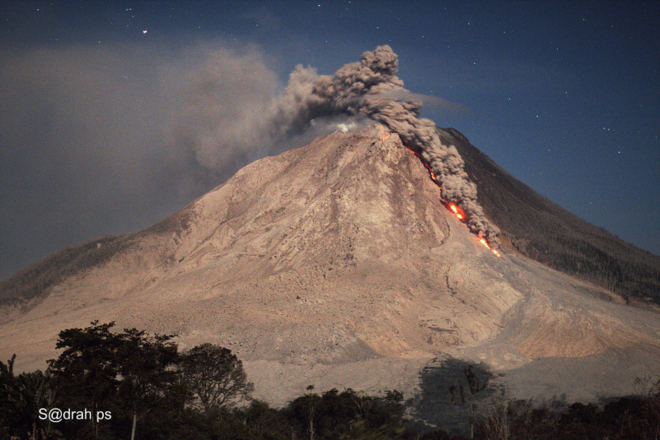 |
Figure 28. A large pyroclastic flow descended the E flank of Sinabung on 29 November 2016 in this view taken a few kilometers SE of the volcano. . Courtesy of Sadrah Peranginangin. |
Activity during January 2017 was dominated by incandescent block avalanches (figure 29). PVMBG reported 101 ash-bearing explosions with plumes rising up to 1 km above the summit, and pyroclastic flows that traveled up to 3 km ESE and 500 m S. A You Tube video captured a pyroclastic flow and ash plume on 17 January 2017. Ash plumes were reported by the Darwin VAAC on 21 days during the month with plume heights ranging from 3.4-5.5 km altitude.
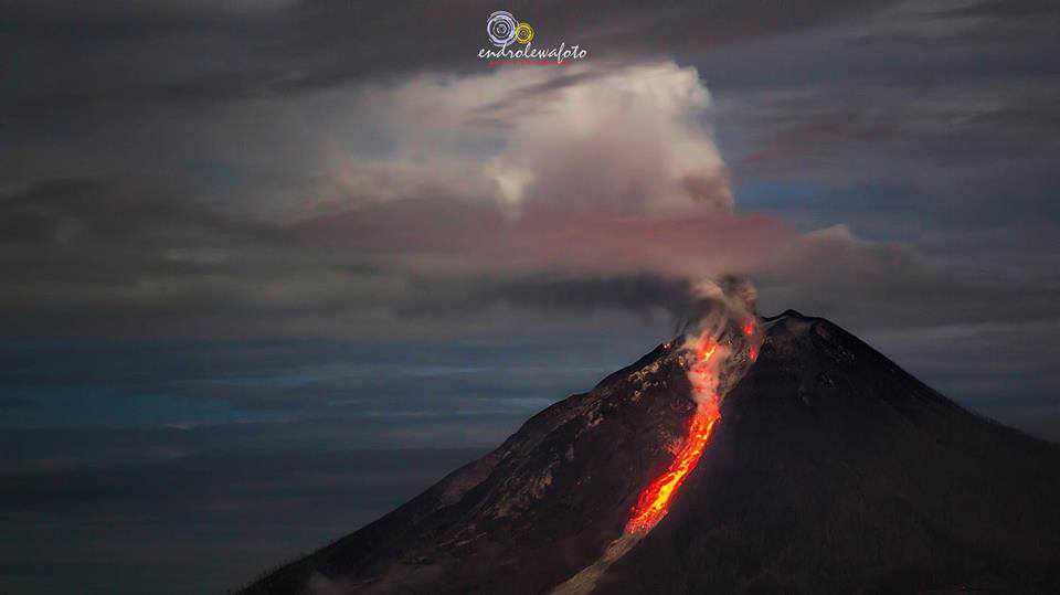 |
Figure 29. Block avalanches descended the E flank of Sinabung many times during January 2017, including at 0134 local time on 17 January, as seen looking to the WSW. Courtesy of Endro Lewa. |
Near-daily ash plumes from 88 explosive events during February 2017 rose to heights of 500-5,000 m above the summit (3.0-7.5 km altitude), and pyroclastic flows traveled 3.5 km E and 1 km S. The Darwin VAAC reported ash emissions on all but three days of the month. A large explosion on 4 February sent an ash plume to 7.4 km altitude that then drifted SE (figure 30), and on 9 February a large ash plume drifted WSW at 6.7 km altitude.
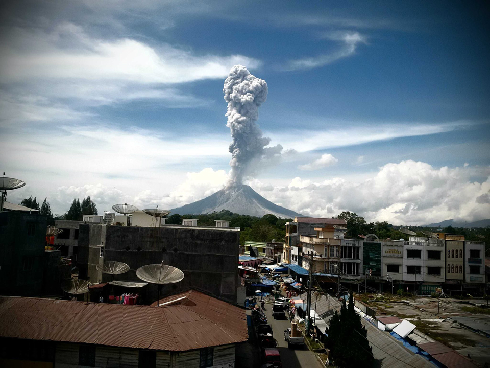 |
Figure 30. Photo of an ash plume at Sinabung on 4 February 2017 that rose more than 5 km above the summit and slowly drifted SE. Photo taken from Kabanjahe, about 13 km SE. Courtesy of Sadrah Peranginangin. |
Block avalanches continued to travel 500-2,000 m down the ESE flank during March 2017. Ash plume heights ranged from 500 to 3,000 m above the summit (3.0-5.5 km altitude) during the 37 explosion events reported by PVMBG (figure 31). Pyroclastic flows traveled 2.5 km down the S flank. The highest plumes of the month were recorded on 17 and 18 March; they rose to 5.5 km altitude and drifted W and WSW. The Darwin VAAC reported ash plumes during 21 days of the month.
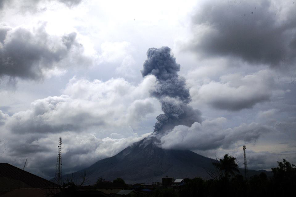 |
Figure 31. Photo of an ash plume at Sinabung on 29 March 2017 at 1548 local time, in this view looking W. Courtesy of Igan S. Sutawijaya. |
During April 2017, block avalanches were observed traveling between 800 and 3,500 m down the SSE flank (figure 32), and 104 explosions were recorded by PVMBG. Ash plumes from these explosions rose to heights of 800 to 3,500 m above the summit. Pyroclastic flows descended 2.8 km down the S flank. A large explosion on 9 April reported in a VONA by a ground observer sent an ash plume to 8.4 km altitude, drifting SE. Pyroclastic flows were also observed on the SE flank. The Darwin VAAC reported ash plumes on 22 days of the month.
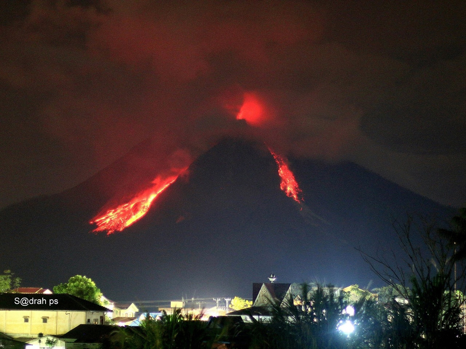 |
Figure 32. Pyroclastic flows descended the S flank (left) and block avalanches descended the E flank of Sinabung near midnight on 4 April 2017, while a small explosion took place at the summit. Image taken from a small village a few kilometers from the base of the SE flank. Courtesy of Sadrah Peranginangin. |
Ash plumes rose between 500 and 6,000 m above the summit during May 2017. Eighty-seven explosive events were recorded (figure 33), and block avalanches were observed traveling 500-1,500 m down the S and SE flanks. The Darwin VAAC reported ash plumes on 26 days during the month. A series of large explosions during 17-20 May resulted in several plumes that rose to altitudes between 6.1 and 8.8 km, in addition to numerous others at lower altitudes between 3.7 and 5.8 km. As of late May, over 9,000 people were still displaced from the volcano, living in either shelters or evacuation camps, according to BNPB.
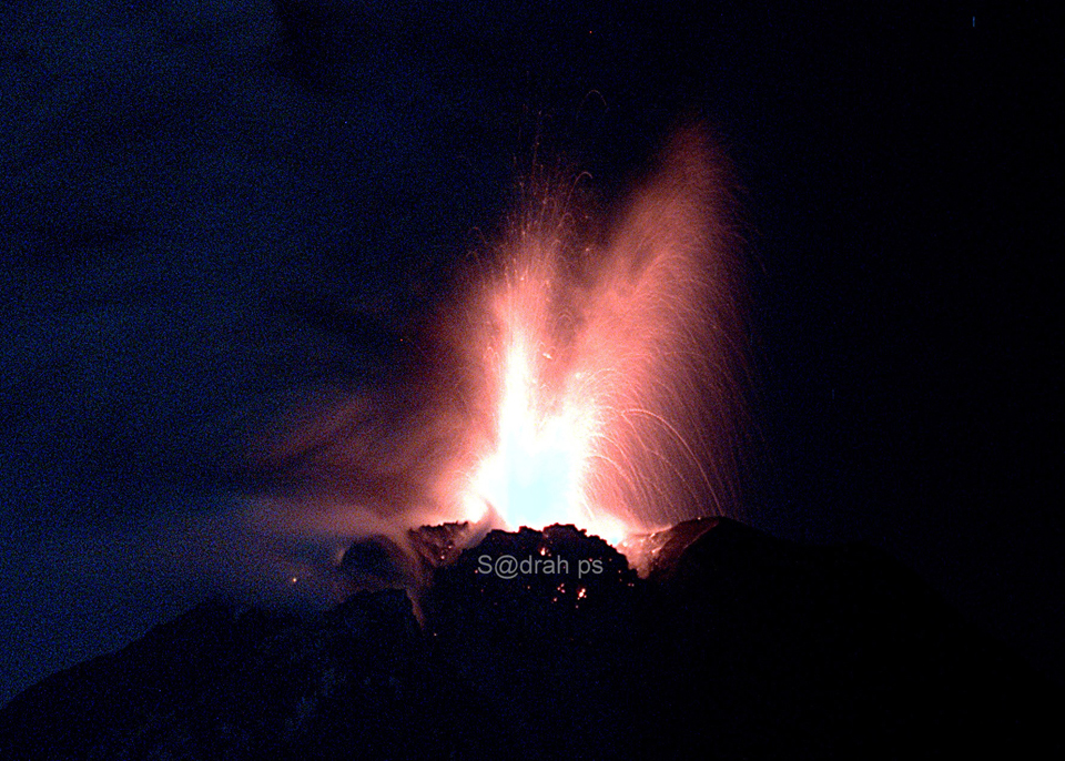 |
Figure 33. Strombolian activity at the summit of Sinabung on 1 May 2017. Courtesy of Sadrah Peranginangin. |
Incandescent block avalanches and pyroclastic flows were persistent during June 2017. They moved down the SE and S flanks up to 2,500 m. PVMBG reported 105 explosive events with plume heights ranging from 500-4,000 m above the summit (figure 34). The largest explosions of the month, on 17 June, generated ash plumes that rose to 6.4 km altitude and drifted 15 km SW. The Darwin VAAC reported ash emissions every day except for 28 June.
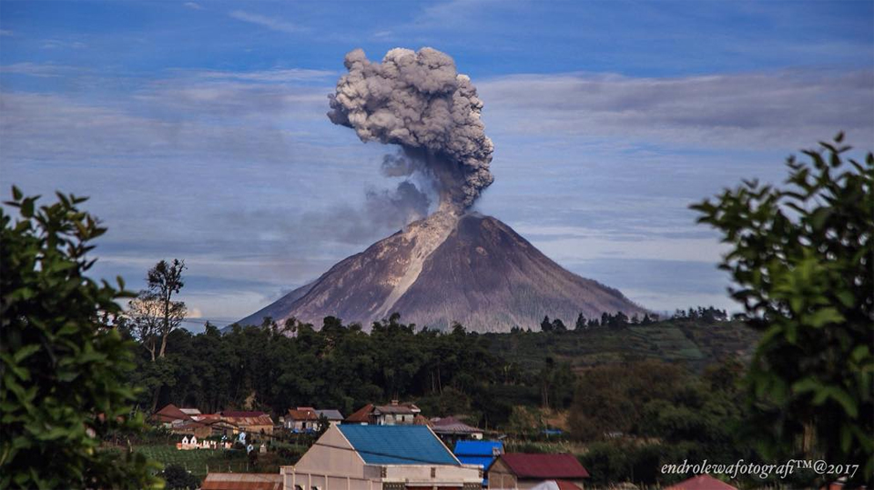 |
Figure 34. Ash plume rose from Sinabung on 26 June 2017. The view is from a small village about 7 kilometers ENE of the summit. Courtesy of Endro Lewa. |
PVMBG reported 91 explosive events during July 2017 that produced ash plumes that rose 500-3,500 m above the summit. They also noted four pyroclastic flows that traveled 1-3 km down the S and SE flanks. Block avalanches continued on the S and E flanks, traveling as far as 3 km. The Darwin VAAC issued reports on 24 days during July. The largest explosions occurred on 20 and 23 July when ash plumes rose to 5.8 and 6.1 km altitude and drifted WSW, ENE, and SE (figure 35).
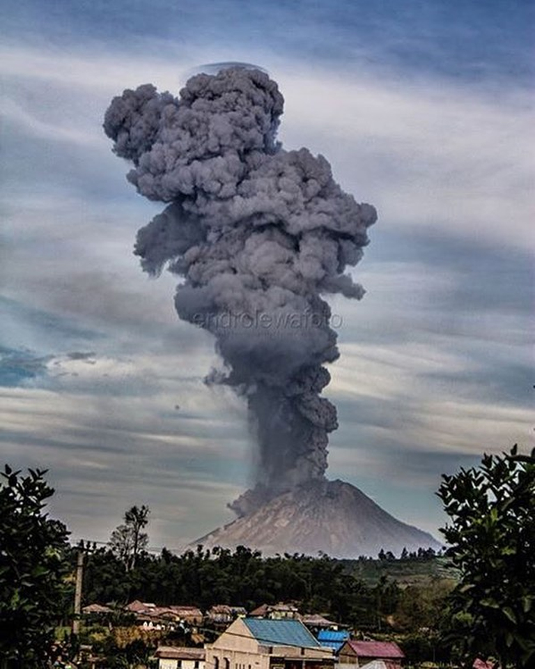 |
Figure 35. A large ash plume from Sinabung rose more than 5 km above the summit on 20 July 2017. The view is from a small village about 7 kilometers ENE of the summit. Courtesy of Endro Lewa. |
Although fewer explosive events (61) were reported during August, block avalanches continued to travel 500-2,300 m down the SE flank. Ash plumes rose 500-2,000 m above the summit; 22 pyroclastic flows traveled up to 4.5 km down the SE flank. The Darwin VAAC issued reports of ash emissions on 17 days of the month.
A large explosion on 2 August sent ash emissions to 5.5-6.4 km altitude (figure 36). The S-drifting plume brought ashfall to the communities of the Ndokum Siroga District (SE), Simpang (7 km SE), Gajah (8 kmE), Kabanjahe (13 km SE), and Naman Teran (5 km NE) (figures 37 and 38). PVMBG reported that the explosions of 2 August destroyed the lava dome at the summit, which had grown since April 2017 to about 2.3 million m3 in size before the explosion (figure 39). The volume of the lava dome was an estimated 23,700 m3 on 6 August, after the explosions.
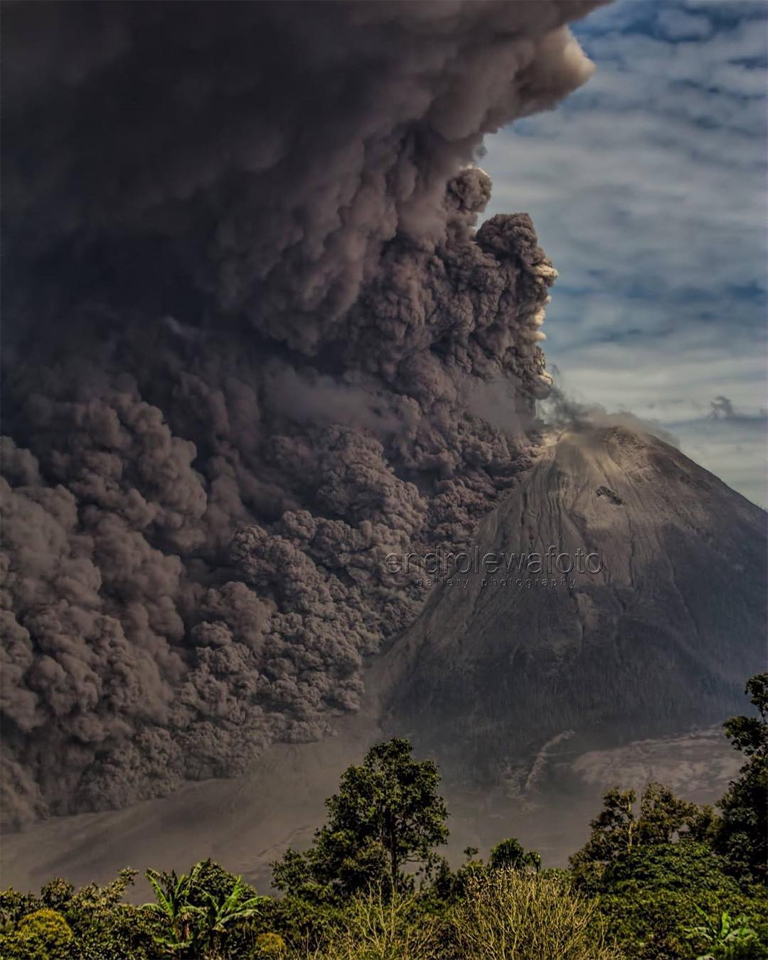 |
Figure 36. Photo showing the large eruption from Sinabung on 2 August 2017, with a dark ash plume and pyroclastic flows. Image taken 5 kilometers E of the summit, looking W. Courtesy of Endro Lewa. |
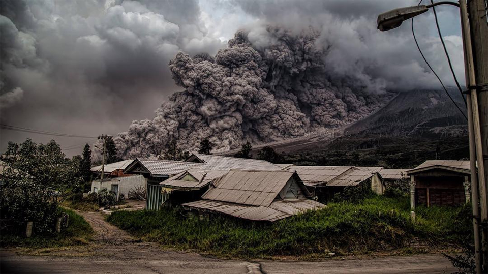 |
Figure 37. Many communities were affected by ashfall and pyroclastic flows from the large explosion at Sinabung on 2 August 2017. This village is located near the base of the E flank. Courtesy of Endro Lewa. |
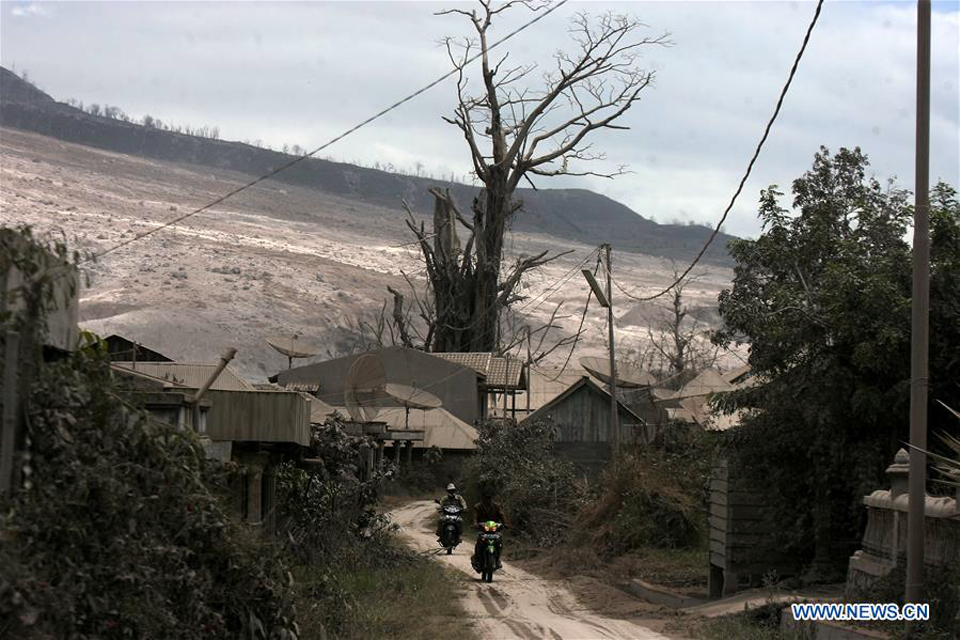 |
Figure 38. A village on the SE flank of Sinabung, was covered with ash on 3 August 2017 after a large eruption the previous day that sent a column of ash to 4.2 km altitude and a pyroclastic flow down the adjacent slope, destroying vegetation in its path. Courtesy of Xinhuanet (Xinhua/YT Haryono). |
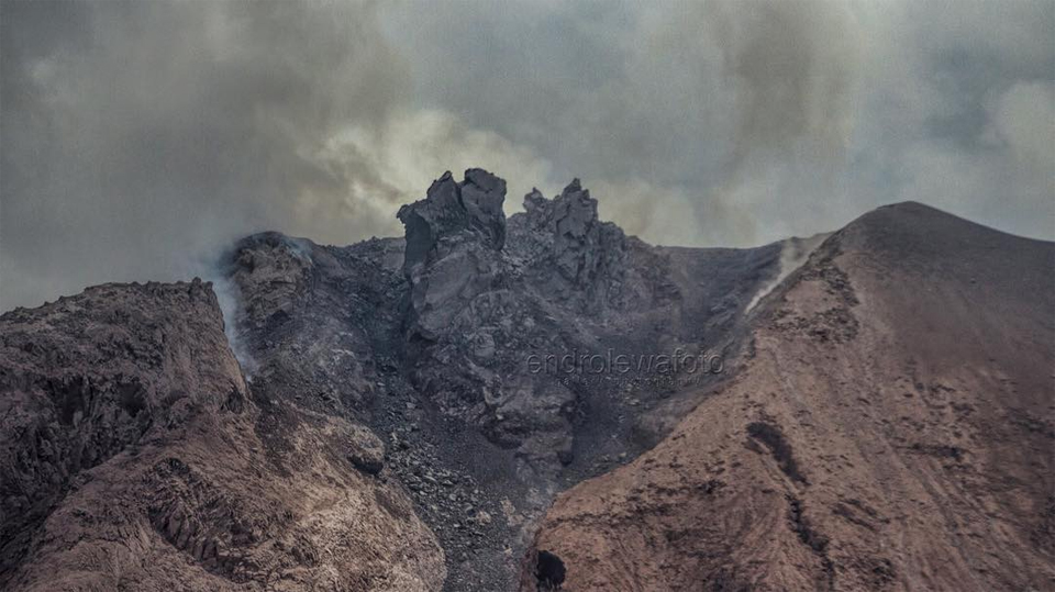 |
Figure 39. The dome at Sinabung on 3 August 2017 one day after its destruction in a large explosion. The volume according to PVMBG was 2.3 million cubic meters in early July and measured only 23,700 cubic meters after the explosion. Courtesy of Endro Lewa. |
The explosions also produced pyroclastic flows that traveled SE and E 2.5-4.5 km and reached the Laborus river, increasing the size of a natural dam on the river that had been evolving from previous deposits. Ashfall was also reported to the E and NE at Berastagi (12 km E). Hot spots were recorded in satellite imagery on 6 and 7 August. Additional ash plumes to similar altitudes (5.5-6.4 km) were reported several other times during August (figure 40 and 41).
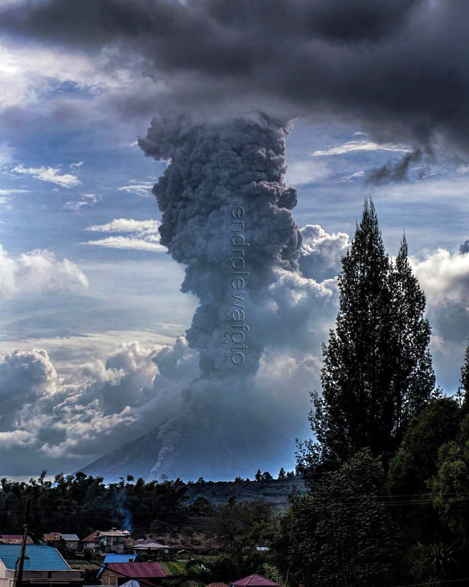 |
Figure 40. An explosion at Sinabung on 8 August 2017. The ash plume rises 2,000 m and a pyroclastic flow descends the E flank in this view from a small village about 7 km ENE of the summit. Courtesy of Endro Lewa. |
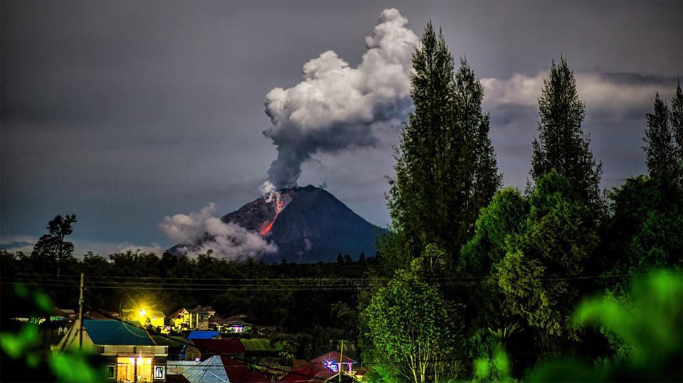 |
Figure 41. Ash and steam plumes and block avalanches at Sinabung on 25 August 2017 in this view from a small village about 7 km ENE of the summit. Courtesy of Endro Lewa. |
The impact of numerous pyroclastic flows on the SE and E flanks during 2016-2017 caused a natural dam to form on the Laborus River near Desa Sukanalu and Kutanonggal Village (figure 42). The estimate of the area covered by water behind the dam was over 100,000 m2 prior to the early August explosions, about one-tenth the size of Lake Laukawar, located further upstream.
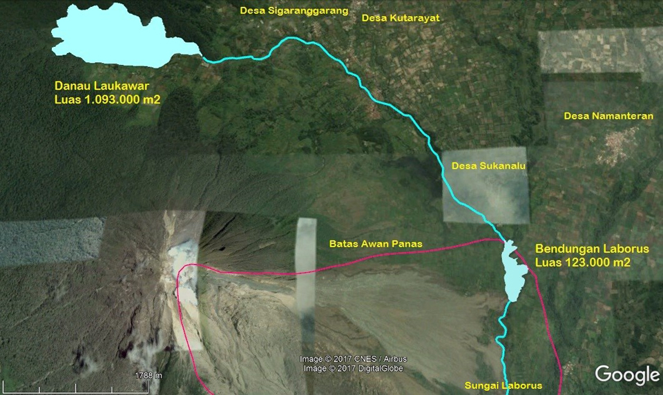 |
Figure 42. A natural dam on the Laborus River (right, 'Bendungan Laborus') was created by numerous pyroclastic flows; the lake area was 123,000 square meters prior to the 2-3 August explosions. Courtesy of PVMBG (Kegiatan Gunungapi Sinabung Pasca Letusan 2-3 Agustus 2017, 22 August 2017). |
Activity diminished only slightly during September 2017. PVMGB reported 55 explosive events with ash plumes that rose 500-4,000 m above the summit (figure 43). Block avalanches fell 500-1,500 m down the SE flank, and five pyroclastic flows were observed in the same area which traveled 1.5 – 2.0 km. Reports of ash emissions were issued by the Washington VAAC on 17 days of the month. The highest ash plume during the month rose to 6.4 km altitude on 25 September.
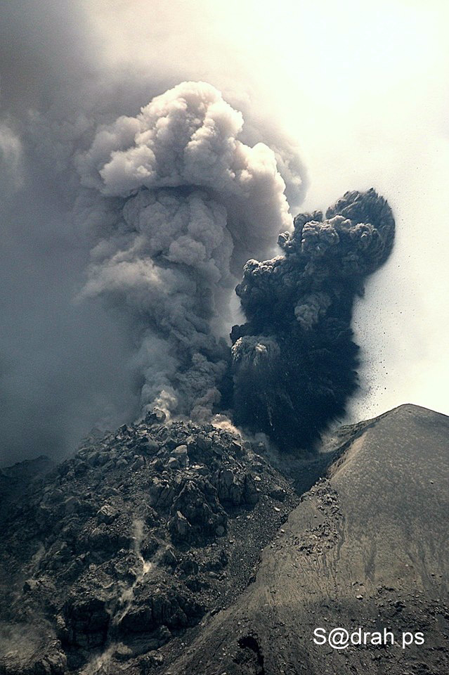 |
Figure 43. A lava dome and ash plume at the summit of Sinabung on 17 September 2017. Courtesy of Sadrah Peranginangin. |
Thermal anomalies. Thermal anomalies persisted throughout October 2016-September 2017. MODVOLC thermal alerts were reported 1-10 times every month except for June 2017. The MIROVA system recorded persistent low to moderate radiative power (figure 44) consistent with the dome growth, explosions, and block avalanches reported by PVMBG.
 |
Figure 44. Thermal anomaly data shown on a MIROVA graph of log Radiative Power at Sinabung for the year ending 18 December 2017. Persistent intermittent pulses of thermal energy are consistent with dome growth and block avalanches reported by PVMBG. Courtesy of MIROVA. |
References: Associated Press, 2017, Raw: Indonesia's Sinabung Volcano Spews Hot Ash (URL: https://www.youtube.com/watch?v=R3KhjpHVeaw), posted to YouTube 17 January 2017.
Geological Summary. Gunung Sinabung is a Pleistocene-to-Holocene stratovolcano with many lava flows on its flanks. The migration of summit vents along a N-S line gives the summit crater complex an elongated form. The youngest crater of this conical andesitic-to-dacitic edifice is at the southern end of the four overlapping summit craters. The youngest deposit is a SE-flank pyroclastic flow 14C dated by Hendrasto et al. (2012) at 740-880 CE. An unconfirmed eruption was noted in 1881, and solfataric activity was seen at the summit and upper flanks in 1912. No confirmed historical eruptions were recorded prior to explosive eruptions during August-September 2010 that produced ash plumes to 5 km above the summit.
Information Contacts: Pusat Vulkanologi dan Mitigasi Bencana Geologi (PVMBG, also known as Indonesian Center for Volcanology and Geological Hazard Mitigation, CVGHM), Jalan Diponegoro 57, Bandung 40122, Indonesia (URLs: http://www.vsi.esdm.go.id/, https://magma.vsi.esdm.go.id/); MAGMA Indonesia, Kementerian Energi dan Sumber Daya Mineral, (URL: https://magma.vsi.esdm.go.id/); Darwin Volcanic Ash Advisory Centre (VAAC), Bureau of Meteorology, Northern Territory Regional Office, PO Box 40050, Casuarina, NT 0811, Australia (URL: http://www.bom.gov.au/info/vaac/); MIROVA (Middle InfraRed Observation of Volcanic Activity), a collaborative project between the Universities of Turin and Florence (Italy) supported by the Centre for Volcanic Risk of the Italian Civil Protection Department (URL: http://www.mirovaweb.it/); Hawai'i Institute of Geophysics and Planetology (HIGP) - MODVOLC Thermal Alerts System, School of Ocean and Earth Science and Technology (SOEST), Univ. of Hawai'i, 2525 Correa Road, Honolulu, HI 96822, USA (URL: http://modis.higp.hawaii.edu/); Xinhua News (URL: http://news.xinhuanet.com/english/2017-08/03/c_136497362.htm); Igan S. Sutawijaya (URL: https://www.facebook.com/igansutawijaya/); Endro Lewa (URL: https://www.instagram.com/endro_lewa/); Sadrah Peranginangin (URL: https://www.facebook.com/sadrah.peranginangin).